Note: Descriptions are shown in the official language in which they were submitted.
IDENTIFYING SPATIAL RECORDS
CROSS-REFERENCE TO RELATED APPLICATIONS
[0001] This application claims the benefit of U.S. Provisional Patent
Application No.
62/359,412 filed July 7, 2016 and entitled "Identifying Spatial Records,"
which is
incorporated herein by reference in its entirety.
FIELD
[0002] The present specification relates to search engines.
BACKGROUND
[0003] In recent years, online search services have changed the way that
people
obtain information on assets and services of their interest. Users are now
able to
navigate up-to-date listings for assets and services using a variety of
different
communication devices (e.g., smart phones, personal computers, personal
digital
assistants (PDAs), etc.), and are doing so with increasing regularity.
SUMMARY
[0004] Although users of online real estate search services may have vast
amounts
of real estate information at their fingertips, they are often faced with the
burdensome
task of sifting through listings that include incomplete information. The
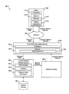
subject matter
described herein provides a description of a search tool for filtering search
results that
may, for instance, be leveraged by websites or mobile applications associated
with
online real estate services to enhance user experience by allowing users to
conduct
searches in a more intuitive manner. In particular, such websites or mobile
applications
may be able to leverage the techniques described herein to provide their users
with a
map-based polygonal search function that is accurate and relatively
computationally
inexpensive on the backend.
[0005] In some aspects, the subject matter described in this specification
may be
embodied in methods that may include the actions of receiving, at a computer
system,
1
CA 2972875 2017-07-07
=
data identifying a polygon with a plurality of edges that are connected and
enclose one
or more spatial regions, the polygon being positioned on a coordinate system,
identifying, by the computer system, a plurality of lines to represent the
polygon based
on the plurality of edges, accessing, by the computer system, information that
identifies
a spatial record positioned at a location on the coordinate system using a
spatial index
that includes spatial data and non-spatial data, generating, by the computer
system, a
ray that emanates from the spatial record and that is projected in a
particular direction,
determining, by the computer system, whether the location of spatial record is
included,
at least partially, within the one or more spatial regions based, at least in
part, on a
number of times that the ray intersects the plurality of lines, and
outputting, by the
computer system, information that identifies whether the spatial record
located, at least
partially, inside of the polygon based on the determination.
[0006] Other implementations of this and other aspects include
corresponding
systems, apparatus, and computer programs, configured to perform the actions
of the
methods, encoded on computer storage devices. A system of one or more
computers
can be so configured by virtue of software, firmware, hardware, or a
combination of
them installed on the system that in operation cause the system to perform the
actions.
One or more computer programs can be so configured by virtue of having
instructions
that, when executed by data processing apparatus, cause the apparatus to
perform the
actions.
[0007] These other versions may each optionally include one or more of the
following features. In some implementations, the spatial record is determined
to be
located, at least partially, inside of the polygon based on the ray
intersecting the plurality
of lines an odd number of times.
[0008] In some examples, the spatial record is determined to be located, at
least
partially, outside of the polygon based on the ray intersecting the plurality
of lines an
even number of times. In some implementations, lines that are parallel to the
ray are
excluded from a count of the number of times that the ray intersects the
plurality of
2
CA 2972875 2017-07-07
lines. In some examples, the particular direction is a substantially
horizontal direction or
a substantially vertical direction across the coordinate system.
[0009] In some implementations, identifying the plurality of lines may
include
segmenting, by the computer system, the polygon into a plurality of subparts,
generating, by the computer system, a plurality of line sets for the plurality
of subparts,
each of the plurality of line sets including one or more lines that define a
portion of the
one or more spatial regions that is contained within a corresponding one of
the plurality
of subparts, and adding, by the computer system, lines from the plurality of
line sets to
the plurality of lines. In addition, a subpart that does not include an edge
intersecting a
perimeter of the subpart is, in some examples, excluded from the generating
and the
adding. In some examples, a line parallel to the ray is excluded from and not
added to
the plurality of lines. The plurality of subparts may, in some of such
implementations,
include a plurality of cells within a bounding box for the polygon. In some
examples, the
coordinate system is a Cartesian coordinate system.
[0010] In some implementations, the subject matter described in this
specification
may be embodied in search engine system comprising a search corpus database
that
includes at least one index of a plurality of records, each record including
spatial data
identifying a location within a geographic reference frame and non-spatial
data; and a
location-based search engine in data communication with the search corpus to
execute
searches thereon, the location-based search engine to perform operations
comprising:
receiving a definition of a geographic area in the geographic reference frame,
the
definition including a plurality of boundaries of the geographic area and, for
each record
of the plurality of records, casting a ray within the geographic reference
frame, wherein
the ray emanates from the location within the geographic reference frame
identified by
the spatial data, counting a number of intersections of the ray with the
boundaries,
determining, based on the number count of the intersections, whether the
location
identified by the spatial data is within the geographic area, and outputting
an indication
of whether the location is within the geographic area, wherein each ray has a
same
direction within the geographic reference frame.
3
CA 2972875 2017-07-07
=
[0011] Other implementations of this and other aspects include
corresponding
apparatus and computer programs configured to perform the actions of the
operations
performed by the search engine system. In addition, other implementations also
include
methods that perform the actions of the operations performed by the search
engine
system.
[0012] These other versions may each optionally include one or more of the
following features. In some implementations, the index solely indexes the
spatial data
and an identifier of the record.
[0013] In some implementations, the index indexes both the spatial data and
at least
some of the non-spatial data.
[0014] In some implementations, for each record of the plurality of
records, the
location-based search engine determines that the location is within the
geographic area
in response to the number of intersections being an odd number.
[0015] In some implementations, for each record of the plurality of
records, the
location-based search engine determines that the location is outside the
geographic
area in response to the number of intersections being an even number.
[0016] In some implementations, the search engine system further comprises
a web
crawler to extract the spatial data and the non-spatial data from a plurality
of web
pages, and an indexer to receive the extracted the spatial data and the non-
spatial data
from the web crawler and index at least the spatial data within the index.
[0017] In some implementations, the geographic reference frame is a two-
dimensional reference frame, the geographic area is a polygonal area, and the
boundaries are edges of the polygonal area.
4
CA 2972875 2017-07-07
[0018] In some implementations, the rays are lines within the two-
dimensional
reference frame, and the direction of the rays is a direction having a slope
of zero or a
slope of one.
[0019] In some implementations, the operations performed by the location-
based
search engine further comprise performing a subsequent search of the records
that
include spatial data identifying locations within the geographic area, wherein
the
subsequent search compares the non-spatial data to one or more search
parameters.
[0020] The subject matter described in this specification can be
implemented in
particular embodiments so as to realize one or more of the following
advantages. For
example, the subject matter described by this specification provides a
location-based
search system that facilitates search and retrieval of spatial records based
on a polygon
search using a spatial index that indexes spatial data and non-spatial data.
This spatial
index that indexes spatial data and non-spatial data improves the execution of
a
computer system executing a spatial search based upon a received polygon. This
spatial index that indexes spatial data and non-spatial data allows for
spatial records to
be filtered out based on non-spatial search criterions (e.g., price, number of
bedrooms,
number of bathrooms, one or more product specifications, or the like) before
execution
of one or more subsequent processing stages that are computationally expensive
such
as ray casting operations. This filtering of spatial resources/records prior
to performing
subsequent processing stages that are computationally expensive reduces the
amount
of Central Processing Unit (CPU) resources, memory resources, bandwidth, and
power,
used by a computing system performing a spatial records search based on a
received
polygon using the spatial index disclosed by this specification. Moreover,
since the
number of spatial records that are identified for subsequent processing stages
that are
computationally expensive can be filtered, and the number of records processed
by
these subsequent stage reduced, execution time of a polygon search is also
reduced.
This results in a computer system that can perform a spatial records search
based on a
received polygon in a manner that is faster than conventional spatial search
methods.
CA 2972875 2017-07-07
[0021]
The details of one or more implementations are set forth in the accompanying
drawings and the description below. Other potential features and advantages
will
become apparent from the description, the drawings, and the claims.
BRIEF DESCRIPTION OF THE DRAWINGS
[0022] FIGS. 1 and 2 illustrate example search engine systems for determining
whether a spatial record is located within a polygon.
[0023] FIG. 3 is a flowchart of an exemplary process for determining whether a
spatial
record is located within a polygon.
[0024] FIG. 4 is a diagram of exemplary computing devices.
[0025] Like reference symbols in the various drawings indicate like elements.
DETAILED DESCRIPTION
[0026] FIG. 1 depicts an example search engine system 100 for determining
whether
a spatial record is located within a polygon. The system 100 may include a
client device
110, a network 120, a front-end application server 130, a location-based
search engine
140, a search corpus database 150, a ranking engine 160, and a value
estimation
engine 170.
[0027] Client device 110 may be representative of one, or multiple, client
devices.
The client device 110 may include a mobile computing platform or a non-mobile
computing platform. Mobile computing platforms may include, for example, a
smartphone, tablet, laptop computer, or other thin client devices. Non-mobile
computing platforms may include, for example, desktop computers, set top box
entertainment systems, video game consoles, or the like. Client device 110 may
be
configured to communicate with front-end application server 130 via network
120 using
one or more communication protocols.
6
CA 2972875 2017-07-07
=
[0028] The client device 110 of system 100 may include at least a processor
111 and
a memory 112. The memory 112 may provide for the storage of computer program
code associated with one or more applications installed on client 110. The
applications
may include, for example, a browser 113 or mobile application 114. Processor
111 may
be configured to execute the stored computer program code in a manner that
allows
client 110 to realize the functionality provided by the applications.
Processor 111 may
also be configured to execute instructions to realize the functionality
associated with any
of the actions attributed to client 110 below.
[0029] The client 110 may be able to access one or more web based applications
133
hosted by front-end application server 130 via network 120 using browser 113.
Such
web based applications may include, for example, an application that
facilitates
identification of resources or records that include information for one or
more
properties/units or other entities that may be available for sale, for lease,
or that provide
a particular service. An entity may include any item that may be available for
sale or
lease such as, for example, a book, a clothing item, a motor vehicle, a
consumer
electronic item, a house, an apartment, or the like. Alternatively, an entity
may include a
party that provides a service such as, for example, a restaurant, a barber
shop, a day
care facility, a school, a doctor's office, a law office, a government agency,
or the like.
Web application 133 may utilize one or more back-end components in order to
identify
one or more resources or records that include information for one or more
entities
based on search input parameters. In certain instances, web application 133
may
utilize the methods set forth herein to identify a set of one or more
resources that are
responsive to a query and include listing information for one or more
properties, or
information for one or more other entities.
[0030] Identification of resources or records may be achieved by using client
device
110 to search one or more databases such as, for example, search corpus
database
150 and then using one or more back-end components to identify and return
ordered
search results to client device 110. In some examples, the returned search
results
7
CA 2972875 2017-07-07
=
include graphical and/or textual representations of corresponding resources or
records
and the information included in the corresponding resources or records. A user
may
initiate a search with client device 110 by interacting with a map provided by
a graphical
user interface of web application 133 via a browser 113. For example, a user
may input
a search query by drawing one or more polygons or other shapes around a
location of
interest on such a map. Such polygons may, for instance, be effectively drawn
by way
of interaction between one or more components of client device 110 and the
user's
finger(s), a stylus, and/or another pointing device. In some implementations,
such a
map may be annotated with graphical indicia that reflect the edges of one or
more
polygons or portions thereof that the user of client device 110 has drawn or
is currently
drawing. For example, such graphical indicia may correspond to an outline of
one or
more polygons or portions thereof that the user of client device 110 has drawn
or is
currently drawing.
[0031] Client device 110 may then generate a query to identify resources or
records
that include listing information for one or more properties that may reside
within
geographic locations associated with the one or more polygons or other shapes
drawn
by the user on the map provided by such a graphical user interface. In some
instances,
the client device 110 may generate a query based on one or more user-drawn
polygons
and/or user input having been provided into one or more search fields provided
by web
application 133 via a browser 113. Upon generating a search query, client
device 110
may transmit the search query to front-end application server 130 over network
120.
[0032] The search query that is sent to front-end application server 130 over
network
120 may, in some instances, represent or include data that identifies one or
more
polygons having been drawn by a user of client device 110. The backend system
may
identify a set of search results in response to the search query, such as a
set of
resources/records that include listing information for one or more properties
that are
geographically-located within the boundaries of one or more polygons
identified in the
received search query, rank each search result in the set of search results,
and then
return the set of search results that are responsive to the received query to
the front-end
8
CA 2972875 2017-07-07
=
application server 130. The front-end application server 130 may then forward
the
search results back to client device 110.
[0033] The search results may be displayed on a graphical user interface
associated
with client device 110 in a variety of different ways that may assist a user
in
understanding and interpreting the search results. For instance,
representations of the
search results may be displayed as a list, where each representation in the
list is
ordered according to a rank determined by one or more backend components of
system
100 such as, for example, ranking engine 160. Alternatively, or additionally,
the search
results may be represented as graphical icons that are plotted on a map of a
geographical area and each correspond to a particular resource identified as a
search
result that is responsive to a received search query. The location of each
graphical icon
on the map may be indicative of the location of one or more properties for
which the
corresponding resource includes listing information. Such a map may, for
instance,
correspond to a map onto which one or more polygons identified by the received
search
query were previously drawn by a user of client device 110. In some examples,
graphical icons may be presented on the map along with graphical indicia that
reflects
one or more polygons identified by the received search query were previously
drawn by
a user of client device 110, such that each graphical icon is shown as being
located
within the boundaries of at least one of such one or more polygons. In certain
instances, search results may be displayed as both a ranked list in a first
portion of the
graphical user interface and as a plot of graphical icons on a map in a second
portion of
the graphical user interface. Other ways of displaying search results also
fall within the
scope of this specification.
[0034] Separate from browser 113, a client device 110 may also be able to use
a
mobile application 114 in order for a user of client device 110 to avail
himself of the
same, or similar, functionality that was described above as being provided by
a web
application 133 via browser 113. Mobile application 114 may include an
executable
software program that was previously downloaded from a mobile application
provider.
Mobile application 114 may be configured to relay commands input by a user
such as,
9
CA 2972875 2017-07-07
for example, search queries that represent or include polygon data to the
front-end
application server 130. After receiving a search query from mobile application
114, the
front-end application server 130 may request that one or more backend
components
execute the search query, rank the search results, and then return the ranked
search
results to mobile application 114, which may display the search results as a
ranked list
of resources or records that each include listing information for one or more
properties,
as plotted graphical icons on a map, or a combination thereof.
[0035] Network 120 may be configured to facilitate connectivity between a
client
device 110 and the front-end application server 130. Client 110 and front-end
application server 130 may be connected to network 120 via one or more wired,
or
wireless, communication links. Network 120 may include any combination of one
or
more types of public and/or private networks including but not limited to a
local area
network (LAN), wide area network (WAN), the Internet, a cellular data network,
or any
combination thereof.
[0036] Front-end application server 130 may include at least a processor 131
and a
memory 132. The memory 132 may provide for the storage of computer program
code
associated with one or more applications hosted by front-end application
server 130.
The applications may include, for example, a web application 133 that may
facilitate
identification of resources or records that include listing information for
one or more
particular properties that may be available for sale, for lease, or that
provide a particular
service. Processor 131 may be configured to execute the stored computer
program
code in a manner that allows front-end application server 130 to realize the
functionality
provided by the applications. Processor 131 may also be configured to execute
instructions to realize the functionality associated with any of the actions
attributed to
front-end application server 130 below.
[0037] Front-end application server 130 may serve as an interface between the
client
110 and the back-end components of system 100 that may include, for example, a
location-based search engine 140, search corpus database 150, ranking engine
160,
CA 2972875 2017-07-07
and value estimation engine 170. Front-end application server 130 may be
comprised
of one or more server computers. Front-end application server 130 may be
configured
to receive commands from a client device 110, and translate those commands, if
necessary, into a format that is compatible with one or more back-end network
components. Front-end application server 130 may also employ network security
applications such as, for example, a firewall, user authentication,
subscription
verification, or the like in an effort to supervise access to one or more back-
end network
components, if necessary.
[0038] Front-end application server 130 may also facilitate session management
for
each browsing session initiated by each respective client device 110 that is
currently
using a browser 113, or mobile application 114, to avail itself of the
services provided by
the web application 133. For instance, front-end application server 130 may
employ
functionality to associate an identifier with each query received by the front-
end
application server 130 from a particular client 110. The front-end application
server 130
may later utilize the identifier in order to associate ordered search results
received from
a ranking engine 160 with a query received from a particular client 110. The
identifier
may then be used to return the set of ordered search results to the client
device 110
that initiated the query. The identifier may include a user identifier, device
identifier,
transaction identifier, or the like.
[0039] System 100 may also include a location-based search engine 140.
Location-
based search engine 140 may be configured to receive and execute search
queries that
are associated with a location component. The location component of the search
query
may, for instance, correspond to one or more geographic locations enclosed by
one or
more polygons or other shapes having been drawn by a user via client device
110.
[0040] Location-based search engine 140 may include a web crawler 141, an
indexer
142, and a polygon data processor 143. The location-based search engine 140
may be
hosted by one or multiple server computers. The server computer(s) hosting the
location-based search engine 140 may be the same server computer(s) that
provide the
11
CA 2972875 2017-07-07
front-end application server 130. Alternatively, however, the server
computer(s) hosting
the location-based search engine 140 may be a different set of one or more
server
computer(s) that are configured to communicate with the front-end application
server
130 via one or more public or private networks.
[0041] Web crawler 141 may be configured to traverse computers connected to a
computer network such as, for example, the Internet, to scan and identify data
associated with particular properties. For instance, web crawler 141 may scan
computers associated with a computer network in order to identify resources or
records
such as web pages and other files accessible via the computer network that may
include data associated with one or multiple properties that are currently
being offered
for sale or lease. Alternatively, or in addition, web crawler 141 may scan
computers
associated with a computer network in order to identify resources or records
that may
include data associated with one or more services. The identified resources or
records
or a subset of the raw data associated therewith may be stored in search
corpus
database 150. In some implementations, web crawler 141 may be autonomous
software that is configured to periodically scan computer networks in order to
identify
new, or previously undiscovered, web pages, network accessible files, or other
resources or records associated with one or more properties that are currently
being
offered for sale, for lease, or resources or records associated with one or
more services.
Alternatively, or in addition, the functionality of web crawler 141 may be
performed by
one or more operators of location-based search engine 140. For instance, a
group of
one or more analysts may obtain raw data associated with a property, and store
the raw
data in search corpus database 150. Alternatively, or in addition, it is
contemplated that
a party that offers a property for sale, for lease, or that provides a service
may also
upload raw data associated with the property to search corpus database 150.
[0042] The aggregated set of raw data stored in search corpus database 150 may
comprise a wealth of data describing a wide spectrum of different properties.
For
instance, search corpus database 150 may include data for each known property
that
indicates, for example, the name of the property, the property's location, a
description of
12
CA 2972875 2017-07-07
the property, a value associated with the property, or the like. In some
examples, data
that indicates the property's location may include one or more sets of
geographic
coordinates or other geographic data from which one or more sets of geographic
coordinates may be derived. For instance, the property's location may be
represented
by one or more sets of latitudinal, longitudinal, and/or elevation
coordinates. The value
for the property may include, for example, the price of a property that is
being offered for
sale or for lease. Alternatively, however, the value for a property may
include, for
example, a property rating. Other types of raw data associated with a property
may be
obtained via the data crawling process and stored in search corpus database
150.
13
CA 2972875 2017-07-07
[0043] In some examples, search corpus database 150 may be a relational
database
in which data is logically organized into a series of database tables. In such
examples,
one or more components of location-based search engine 140, such as web
crawler
141 and indexer 142, may operate in conjunction with search corpus database
150 as a
relational database management system ("RDBMS"). In these examples, each
database table in search corpus database 150 may arrange data in a series of
columns
(where each column represents an attribute of the data stored in the database)
and
rows (where each row represents attribute values). In some implementations,
search
corpus database 150 may be an object-oriented database in which data is
logically or
physically organized into a series of objects. In such implementations, one or
more
components of location-based search engine 140, such as web crawler 141 and
indexer
142, may operate in conjunction with search corpus database 150 to manage such
objects. Each object may be associated with a series of attribute values. In
some
examples, search corpus database 150 may be a type of database management
system that is not necessarily a relational or object-oriented database. For
example, a
series of files or documents may be used, where each file or document is
encoded in
JavaScript Object Notation ("JSON") or Extensible Mark-up Language ("XML") and
includes attributes and attribute values. Data included in search corpus
database 150
may be identified by a unique identifier such that data related to a
particular process
may be retrieved from search corpus database 150.
[0044] Indexer 142 may be configured to analyze the raw data obtained during
the
crawling process in order to make the raw data searchable. For instance,
indexer 142
parse the raw data and extract one or more types of relevant data. For
example, the
indexer 142 may analyze the raw data to extract a property's name, a
property's
location, and a value associated with the property. Indexer 142 may then
associate the
extracted data with one or more keywords. The associated keywords may be
compared
to aspects of received search queries in order to determine whether the
extracted data
associated with the keywords is responsive to the search query.
14
CA 2972875 2017-07-07
[0045] In some implementations, indexer 142 may further associate each
property's
location, as represented by one or more sets of geographic coordinates, with
one or
more keywords and/or additional sets of geographic coordinates. For instance,
indexer
142 may associate a given property's location with keywords that represent one
or more
geographic regions within which the given property is located and/or four or
more sets
of geographic coordinates that define vertices or points along boundaries of
one or
more geographic regions within which the given property is located. In some
instances,
each of the one or more geographic regions with which indexer 142 associates a
given
property may serve to represent the given property's location on a different
geographic
scale. For example, indexer 142 may associate a given property with keywords
including the name of the neighborhood within which the given property is
located, the
name of the borough within which that neighborhood is located, the name of the
city
within that borough is located, the name of the state within which that city
is located,
and so on. Similarly, indexer 142 may, for instance, associate a given
property with
various different sets of geographic coordinates including four or more sets
of
geographic coordinates that define a first geographic quadrangle within which
the given
property is located, four or more sets of geographic coordinates that define a
second,
larger geographic quadrangle within which the first geographic quadrangle is
located,
four or more sets of geographic coordinates that define a third, even larger
geographic
quadrangle within which the second geographic quadrangle is located, and so
on. In
this way, indexer 142 may enable properties to be identified through location-
based
searches conducted on a variety of different geographic scales.
[0046] Polygon data processor 143 may be configured to receive a search query
from
front-end application server 130 that originated at client device 110,
identify one or more
polygons that are associated with the search query, and perform one or more
operations to identify indexed resources/records that include listing
information for one
or more properties that are located within the one or more polygons. The one
or more
operations that are performed by polygon data process 143 are described in
further
detail in the discussions of FIGS. 2 and 3 below. At least a portion of the
resources/records that are identified by polygon data processor 143 as being
located
CA 2972875 2017-07-07
within one or more polygons that are associated with the search query may, in
some
examples, serve as search results that are ultimately provided to client
device 110
responsive to search query submission. In some examples, polygon data
processor
143 may also be configured to identify non-polygonal search filters or other
parameters
that are associated with the search query, such as user-submitted keywords
that are
included as part of the search query, and apply such parameters against the
index
generated by indexer 142 before and/or after performing one or more operations
to
identify indexed resources/records that include listing information for one or
more
properties that are located within one or more polygons that are associated
with the
search query.
[0047] The search results may identify, for example, a group of one or
multiple links
that are associated with resources or records that are responsive to the query
received
from client 110. The search result links may reference a resource that
includes
information associated with one or more properties. For instance, the search
result
links may reference web pages that include listing information for one or more
properties. The information included in each resource may be drawn from search
corpus database 150. The set of search results may be substantially unordered,
or
otherwise arranged in an order that is not based on entity value. The search
results
identified by the polygon data processor 143 in response to the received
search query
may then be passed to the ranking engine 160. The location-based search engine
140
may communicate with the ranking engine using one or more public or private
networks.
[0048] System 100 may also include a ranking engine 160. Ranking engine 160
may
be hosted by one or multiple server computers. The server computer(s) hosting
the
ranking engine 160 may be the same server computer(s) that provide the front
application server 130. Alternatively, however, the server computer(s) hosting
the
location-based ranking engine 160 may be a different set of one or more server
computer(s) that are configured to communicate with the front-end application
server
130 via one or more public or private networks.
16
CA 2972875 2017-07-07
[0049] Ranking engine 160 may be configured to perform a series of post
processing
operations on the set of identified search results. The post processing
operations may
determine a ranking score that may be associated with each resource in the set
of
search resources or records based at least on the analysis of a metric
associated with
each entity responsive to a query. For instance, a ranking score may be
determined for
a particular resource based on the amount of time that has elapsed since the
particular
resource has been updated, the availability of one or more properties for
which the
particular resource includes listing information, the interface through which
the particular
resource's listing information is supplied and/or modified, the value by which
one or
more properties associated with the listing information of the particular
resource exceed
the maximum desired value, various verifications associated with the
particular resource
and properties, or a combination thereof. Ranking engine 160 may utilize make
such
determinations based on information provided by location-based search engine
140,
information included in search corpus 150, historical information that is
managed or
accessed by ranking engine 160, and the like. Ranking engine 160 may then
return the
set of ordered results to the front-end application server 130 via one or more
public or
private networks. Front-end application server may then provide the ordered
search
results to client device 110 via network 120.
[0050] Ranking engine 160 may be configured to isolate and analyze search
results
based on a predetermined geographic region. A geographic region may include,
for
example, a neighborhood, a city, a state, a zip code, GPS coordinates,
longitude and
latitude coordinates, a shape drawn by a user on a graphical user interface
map, or the
like. Once a set of search results are isolated by geographic region, the
ranking engine
may analyze characteristics each resource and the one or more properties for
which
each resource includes listing information. For instance, the ranking engine
160 may
determine how much time has elapsed since the particular resource was last
updated,
whether one or more properties for which the particular resource includes
listing
information are currently available or will become available within an
upcoming
timeframe, whether the information included in the particular resource is
supplied
manually through a user interface or automatically through an application
programming
17
CA 2972875 2017-07-07
interface, whether one or more properties for which the particular resource
includes
listing information have prices that exceed a specified price range, whether
any
attributes of the particular resource or one or more properties associated
with the
particular resource, and the like. Ranking engine 160 may utilize make such
determinations based on information provided by location-based search engine
140,
information included in search corpus 150, historical information that is
managed or
accessed by ranking engine 160, and the like. Ranking engine 160 may assign a
score
to each resource identified as responsive a given search query.
[0051] Ranking engine 160 may be configured to make one or more determinations
about a particular resource and assign a ranking score based on such
determinations,
as appropriate. The ranking engine 160 may rank a set of resources or records
based
on the ranking score assigned to each resource in the set of resources or
records. In
some examples, the ranking engine 160 may, before making one or more of such
determinations, determine a ranking score for a particular resource based on
default
criteria such as an initial search ranking score and, after making one or more
subsequent ranking determinations, adjusting the initial search ranking score
for the
particular resource based on one or more of such subsequent ranking
determinations.
Initial ranking scores, subsequent ranking scores, or both, may be based on a
number
of factors including geographic location, popularity, placement in search
result rankings,
recency of the search result (e.g., based an amount of time the resource or
record has
been searchable, an amount of time since the resource or record has been
updated, or
the like), or the like. In some implementations, it may be beneficial to
assign ranking
scores in a manner that favors resources or records that include information
that has
been recently updated over resources or records that include information that
has less
recently been updated. In this way, users may be presented with listing
information that
is known to be relatively fresh and up-to-date, which may be especially
important in
competitive rental markets.
[0052] In some aspects of the present disclosure, ranking engine 160 may be
utilized
only when requested by a user of client device 110. If a user decides to not
use ranking
18
CA 2972875 2017-07-07
engine 160, the search results may be provided to the client device in the
order
determined by location search engine 140. Such order may be, for example,
based on
most expensive price, lowest price, based on an analysis of keyword frequency
in a web
page associated with the search result corresponding to the entity, based on
payments
received to increase a ranking score associated with each entity, or the like,
or any
combination thereof. Accordingly, client 110 may be able to toggle ranking
engine 160
on and off. In some instances, client 110 may be able to adjust ranking engine
160
such that ranking scores are assigned based on specific characteristics of
resources or
records.
[0053] FIG. 2 depicts an example search engine system 200 for determining
whether a
spatial record is located within a polygon. Search engine system 200 may, for
example,
include one or more components that are representative of one or more
components of
search engine system 100, as described above in reference to FIG. 1. In
particular,
search engine system 200 may include components that correspond to location-
based
search engine 140, which includes web crawler 141, indexer 142, and polygon
data
processor 143, as well as search corpus database 150.
[0054] In the example of FIG. 2, it can be seen that location-based search
engine 140
may receive polygon data 202. In some implementations, polygon data 202 may
identify one or more user-defined polygons provided through a client device
that directly
or indirectly communicates with search engine system 200, such as client
device 110 as
described above in reference to FIG. 1. It follows that, in some of such
implementations, location-based search engine 140 may receive the polygon data
202
from a front-end application server, such as front-end application server 130
as
described above in reference to FIG. 1. In some implementations, the location-
based
search engine 140 may also receive a non-spatial search criterion (or search
criteria).
For example, the computer system may also receive non-spatial search criterion
(or
search criteria) related to a real-estate listing such as a number of
bedrooms, number of
bathrooms, price range, or the like. The received non-spatial search criterion
(or search
criteria) may be received from a user profile, a predefined user search
criterion (or
19
CA 2972875 2017-07-07
search criteria), one or more query parameters entered into one or more search
fields
by the user in addition to inputting of the polygon, or the like. The non-
spatial search
criterion (or search criteria) may be input before, after, or during (e.g., a
voice command
input while drawing a polygon) inputting of the polygon.
[0055] As shown at 203, polygon data 202 may identify a polygon 210 that is
positioned on a coordinate system 212. Polygon 210 may, for instance,
represent a
polygon having been provided by a user through a graphical user interface and
onto a
map of the graphical user interface so as to define a custom geographic region
within
which one or more properties to be identified by search engine system 200 are
to be
geographically located. The coordinate system 212 may, for example, define
coordinates, such as Cartesian coordinates, for a finite quantity of points in
two
dimensional space. In some examples, each point in such a finite quantity of
points
may correspond to a different pixel of the map of the graphical user interface
onto which
one or more polygons or shapes, such as polygon 210, have been drawn. In this
way,
the coordinate system 212 may be seen as corresponding to a geographical
coordinate
system. It follows that, in such examples, the amount of geographical area
that is
represented by each pixel of the map, and thus each set of coordinates defined
by
coordinate system 212, directly depends upon the amount of geographical area
that is
represented by the map as presented through the graphical user interface. For
instance, each pixel of a map that, as presented through a graphical user
interface,
represents an entire country, may represent a different city located within
that country,
while each pixel of another map that, as presented through a graphical user
interface,
only represents one city, may represent a different neighborhood or block of
that one
city.
[0056] Polygon data 202 may, for instance, identify each of one or more
coordinates
defined by coordinate system 212 at which each of one or more edges of polygon
210
are positioned. That is, polygon data 202 may effectively represent polygon
210 using
coordinates defined by coordinate system 212. In some examples, polygon data
202
may represent polygon 210 using a set of bounded line segments that are, for
instance,
CA 2972875 2017-07-07
each described as linear functions. In some implementations, polygon data 202
may
also identify the geographic coordinates to which polygon 210 corresponds. For
instance, polygon data 202 may directly or indirectly identify the geographic
coordinates
of the particular geographic locations on the map along which polygon 210 was
drawn.
The identified geographic coordinates can be used to identify respective
entries of a
spatial index of respective real-estate properties stored in the search corpus
150. The
real-estate properties may include apartments, single-family homes, townhomes,
commercial buildings, industrial buildings, or the like that may be available
for rent, for
lease, for sale, or the like.
[0057] Upon receiving polygon data 202, location-based search engine 140 may
determine the geographic coordinates to which polygon 210 corresponds and
perform
one or more operations to identify resources/records that include listing
information for
one or more properties that are located within the confines of the geographic
coordinates to which polygon 210 corresponds. Polygon data processor 143 may,
for
instance, identify a plurality of lines, as described using coordinates
defined by
coordinate system 212 and/or the corresponding geographic coordinates, to
represent
polygon 210. For example, such a plurality of lines identified for polygon 210
may
correspond to line segments 210a-210j, as shown at 204. Furthermore, polygon
data
processor 143 may determine that polygon 210 falls within a particular set of
predefined
geographic regions, such as quadrangles or cells that are formed between
intersecting
lines of latitude and longitude that occur at discrete intervals of
geographical distance.
Polygon data processor 143 may, for instance, initially determine the
quadrangles that
polygon 210 falls within using lines of latitude and longitude that occur at
relatively large
intervals of geographical distance, and thus represent the geographic regions
within
which polygon 210 is located with a relatively low level of resolution. In
some examples,
polygon data processor 143 may initially determine a bounding box for polygon
210,
and then identify each quadrangle within which the bounding box for polygon
210 is at
least partially located. In other examples, polygon data processor 143 may
determine
such quadrangles by identifying the lines of latitude and longitude that
intersect the
plurality of lines representing polygon 210.
21
CA 2972875 2017-07-07
[0058] The search corpus database 150 may include one or more indices that can
be
used to identify quadrangles within the bounding box for the polygon 210, real-
estate
property listing information corresponding to properties geographically
located within the
quadrangles, or both. In some implementations, computational resources (e.g.,
CPU
power, memory usage, power usage, or a combination thereof) required to
execute a
polygon search can be reduced by using the same index for spatial information
(e.g.,
geographic data identifying a quadrangle (or cell), quadrangle (or cell)
identifiers, or the
like) and non-spatial information (e.g., real-estate property listing
information such as
number of bedrooms, number of bathrooms, a property price, or the like). Use
of the
same index for both spatial and non-spatial information reduces the amount of
computational resources required to execute a polygon search by reducing the
number
of relevant real-estate property listings within the bounding box that require
one or more
additional stages of subsequent processing described below. The number of
relevant
real estate property listings are reduced because this initial set of real-
estate property
listings can be filtered using one or more search parameters (e.g., property
value,
number of bedrooms, or the like) that may be submitted in addition to the
polygon. For
example, a resource/record corresponding to a real-estate property that
otherwise
potentially falls within the bounding box of the polygon may be excluded from
further
processing during the subsequent ray-casting stages if it is determined, based
on a
search of the spatial index including both spatial data and non-spatial data,
that the real-
estate property is not associated with a price that falls within a price range
received as a
non-spatial search criterion from the user. Moreover, since real-estate
property listing
data is already included in the index, additional computationally expensive
lookups to
real-estate listing database do not need to be performed once processing of
the polygon
search is complete. For at least these reasons, executing a polygon search
using an
index that includes both spatial and non-spatial data is significantly more
computationally efficient than executing a polygon search using separate
respective
indices for spatial data and non-spatial data.
22
CA 2972875 2017-07-07
[0059] Upon determining the particular set of quadrangles within which polygon
210 is
located, the location-based search engine 140 may use the one or more indices
maintained in the search corpus database 150 to identify resources/records
that include
listing information for one or more properties that are located within the
particular set of
quadrangles. In some examples, each quadrangle may be associated with an
identifier.
In such examples, each resource/record may be stored and managed by search
corpus
database 150 and location-based search engine 140, respectively, in
association with
the identifier that corresponds to the quadrangle within which the one or more
properties
for which each resource/record includes listing information is located.
[0060] Since, as mentioned above, the quadrangles determined by polygon data
processor 143 may be a relatively low resolution, it follows that one or more
of such
quadrangles may cover geographic area that is external to or outside of
polygon 210.
For this reason, it is possible that the location-based search engine 140 may
identify
resources/records that include listing information for one or more properties
that are
located within the particular set of quadrangles, but are not actually located
within the
confines of polygon 210.
[0061] Polygon data processor 143 may therefore perform one or more subsequent
operations to determine whether such identified resources/records include
listing
information for one or more properties that are actually located within
polygon 210. In
the example of FIG. 2, location-based search engine 140 may, for instance,
identify
records A-G as including listing information for properties that are located
within the
same quadrangles as polygon 210. Records A through G may, for instance, each
include listing information for properties at positions [xA,yA] through
[xG,yG] within
coordinate system 212, respectively, as shown at 204. In order to determine
whether
one or more of records A through G is truly located within polygon 210,
polygon data
processor 143 may perform one or more ray casting operations within coordinate
system 212. In some implementations, the identified resources/records may be
pre-
filtered based on the one or more non-spatial search criterion (or search
criteria)
received from a user such number of bedrooms, number of bathrooms, price, or
the like.
23
CA 2972875 2017-07-07
In such instances, the ray casting operations described below may be avoided
for
resources/records that do not satisfy the received non-spatial search
criterion (or search
criteria). Such non-spatial a search criterion (or search criteria) can be
used to search
the non-spatial index that includes both spatial and non-spatial data and
identify for
further ray casting operations only those resources/records that fall within
the polygon
(or a quadrangle associated with the polygon) and satisfy the non-spatial
search
criterion (or search criteria).
[0062] As shown at 204, polygon data processor 143 may generate rays rA
through rG
that emanate from points [xA,yA] through [xo,YG], respectively, are projected
in a
particular direction. In the example of FIG. 2, the particular direction in
which rays rA
through rG that emanate from points [xA,yA] through [xG,YG], respectively, is
a positive
direction along the x-axis of coordinate system 212. Upon generating ray for
each of
records A through G, polygon data processor 143 may determine which, if any,
of the
plurality of identified lines 210a-210j that represent polygon 210 each of
rays rA through
rG intersect. Polygon data processor 143 may then be able to determine whether
or not
each one of records A through G includes listing information for a property
that is
located with polygon 210 based on such an intersection analysis. In some
examples,
polygon data processor 143 may determine whether each of rays rA through rG
intersect
one or more lines that are different from the plurality of identified lines
210a-210j. For
instance, polygon data processor 143 may, in such examples, identify a set of
points
within coordinate system 212 at which outer edges of polygon 210 intersect
with the
borders that define each quadrangle having been identified for polygon 210.
Polygon
data processor 143 may then, for example, define lines that extend from each
point in
the set of identified points to the next. In a way, this may be seen as
generating a
plurality of lines that represent a sort of downsampled version of polygon
210. In these
examples, fewer lines may be used to represent polygon 210, which may serve to
reduce the computational, power, and/or communicative load that is placed on
components of system 100 when performing one or more of the operations
described
herein.
24
CA 2972875 2017-07-07
[0063] The aforementioned rays may be generated so that they emanate in any
direction using lines of any slope. However, in some implementations, the
aforementioned rays may be generated in particular ways to increase the
computational
efficiency of the execution of the polygon search. For example, in some
implementations, the aforementioned rays may be generated so that the rays
only
extend in the horizontal or vertical direction, but not both. The
computational efficiency
of the polygon search may be increased using horizontal rays because the
polygon data
process does not need to perform additional complex calculations based on the
slope of
the ray since the slope is zero. Similar gains in computational efficiency can
also be
achieved using vertical rays due to the reduction in complexity of additional
complex
calculations related to the slope since the slope is undefined. In addition,
rays with a
slope of 1 can also be used to increase the computational efficiency of the
polygon
search for the same reasons. Each of the aforementioned rays will result
system that
yields an increase computational efficiency of execution of a polygon search
by using
less processing resources, less memory resources, and less power resources
than a
system using rays having a slope falling between the values of zero and 1.
[0064] In some implementations, polygon data processor 143 may determine
whether
or not each one of records A through G includes listing information for a
property that is
located with polygon 210 based on the quantity of the plurality of identified
lines 210a-
210j that intersect each corresponding ray. For example, polygon data
processor 143
may identify rays that intersect an odd number/quantity of lines 210a-210j as
being
located within polygon 210, and identify rays that intersect an even
number/quantity of
lines 210a-210j or do not intersect any of lines 210a-210j as being located
outside of
polygon 210. For instance, it can be seen that rA, which emanates from point
[xA,yA]
within coordinate system 212 to which record A corresponds and pass through a
total of
two of the plurality of lines that represent polygon 210 (i.e., lines 210a and
210b),
indicates that point [xA,yA] is located outside of polygon 210 by virtue of
intersecting with
an even number of the plurality of lines that represent polygon 210. On the
other hand,
it can be seen that rB, which emanates from point [xB,yB] within coordinate
system 212
to which record A corresponds and pass through a total of one of the plurality
of lines
CA 2972875 2017-07-07
that represent polygon 210 (i.e., line 210c), indicates that point [xB,y13] is
located within
polygon 210 by virtue of intersecting with an odd number of the plurality of
lines that
represent polygon 210. As described above, in some examples, such processes
may
be performed using lines that extend between each point within coordinate
system 212
at which the outline of polygon 210 intersects with the outline of one of the
one or more
quadrangles having been identified for polygon 210 in place of lines 210a-
210j.
[0065] Polygon data processor 143 may apply logic similar to that which has
been
described in the examples of rA and rB above to determine whether each of
records C
through G are located within polygon 210. It follows that, in this example,
polygon data
processor 143 may (i) determine that records B, D, and E are associated with
properties
that are located within polygon 210 based on determining that rays rB, rip,
and rE each
intersect edges of polygon 210 an odd number of times, (ii) determine that
records A, C,
and F are associated with properties that are located outside of polygon 210
based on
determining that rays rA, rc, and rF each intersect edges of polygon 210 an
even number
of times, and (iii) determine that record G is associated with a property that
is located
outside of polygon 210 based on determining that ray rG does not intersect any
edges of
polygon 210. For this reason, location-based search engine 140 may, for
example,
output search results 220 that reference records B, D, and E, but do not
reference
records A, C, F, or G. Such search results 220 may, for instance, be provided
to one or
more components not shown in FIG. 2, such as that which represents a ranking
engine,
such as ranking engine 160 as described above in reference to FIG. 1.
[0066] In some examples, location-based search engine 140 may apply one or
more
additional filters to such records before outputting search results 220. For
example,
location-based search engine 140 may determine that records B, D, and E are
each
located within polygon 210, but omit references to record D from search
results 220
because the property associated with record D is determined to be outside of a
user-
defined price range. Such filters may be applied before or after performance
of the ray-
casting stages. For example, in some implementations, in order to achieve
gains in
computational efficiency, some or all of such filters may be applied prior to
performing
26
CA 2972875 2017-07-07
=
the ray casting operations described above by searching a spatial index that
includes
spatial data and non-spatial data. In such implementations, location-based
search
engine 140 may, in a situation similar to the example described above in which
the
property associated with record D is outside of a user-defined price range,
simply
eliminate record D from contention before performing ray casting operations
and
therefore not generate ray rp. Alternatively, in other implementations, such
filtering may
be peformed after the performance of the ray-casting stages. Upon providing
search
results 220, system 200 may perform one or more operations to store some or
all of
polygon data 202 and/or data having been derived or generated at system 200
through
performing one or more of the operations described herein based on polygon
data 202.
In some examples, system 200 may store such data in association with an
account that
is registered to the user that drew polygon 210 and/or a client device through
which
polygon 210 was drawn.
[0067] Although polygon 210 has been described herein as representing a user-
drawn
polygon having been submitted as a search query, it is to be understood that
the
polygons and polygon data that may be processed by location-based search
engine 140
may take a variety of other, different forms. For instance, polygon 210 may be
a
polygon that is generated by one or more components of system 100 and/or 200
independent from user-drawn input. In addition, it is to be noted that the
techniques
described herein may also be leveraged to determine whether points are located
within
multiple, different polygons, and even polygons with holes.
[0068] In some examples, system 100 and/or 200 may generate one or more
polygons
based on the location of a client device, such as client device 110 as
described above in
reference to FIG. 1, or some other location that the user of client device 110
has input
as a search parameter. Such search parameters may, for instance, include
keywords
and/or selectable options that serve to indicate a location such as a
neighborhood, a
city, a state, a zip code, or the like. In such examples, system 100 and/or
200 may
maintain or otherwise have access to one or more predefined polygons that
represent
geographic boundaries of a neighborhood, a city, a state, a zip code, or the
like. In this
27
CA 2972875 2017-07-07
way, system 100 and/or 200 may select, from among multiple different
predefined
polygons, a particular polygon that is determined to correspond to the
location that the
user of client device 110 has input as a search parameter. Such predefined
polygons
may, for example, be stored in search corpus database 150 or other electronic
data
storage to which system 100 and/or 200 has access.
[0069] Alternatively, or in addition, system 100 and/or 200 may generate one
or more
polygons based on one or more attributes associated with a client device 110.
For
instance, one of the aforementioned network components may determine the
current
location of a client device 110. Alternatively, the current location of a
client device 110
may be provided to one or more network components of system 100 by a third
party.
Alternatively, or in addition, system 100 and/or 200 may generate one or more
polygons
based on locations that the client device 110 has recently traveled. System
100 and/or
200 may also generate polygons based on other information, such as a desired
commute time as specified by the user.
[0070] In some implementations, some resources/records may be associated with
multiple, different locations. For example, such resources/records may include
information that represents a geographic area, and may thus be associated with
multiple, different locations defining a polygon that encloses such a
geographic area. In
this way, system 100 and/or 200 may be able to determine whether polygon 210
overlaps with one or more other polygons of interest. Such polygons may, for
example,
include predefined polygons that represent geographic boundaries of a
neighborhood, a
city, a state, a zip code, or the like, such as those mentioned above, as well
as one or
more other polygons having been previously drawn by the user of client device
110 or
other users of system 100 and/or 200. In order to determine whether portions
of such
other polygons are located within polygon 210, polygon data processor 143 may,
in
these implementations, generate rays that emanate from points that correspond
to
vertices of such other polygons. This technique may, for instance, be
leveraged to
provide analytics and/or visualizations that yield a variety of insights that
may be of
value to prospective tenants, property owners, property managers, real estate
agents,
28
CA 2972875 2017-07-07
investors, developers, and the like. For instance, this technique may be
leveraged to
produce heat map visualizations that serve to indicate the search popularity
of various
locations within a geographic region, based on the quantity of polygons that
(i) are
drawn by different users of system 100 and/or 200, and (ii) enclose each given
location
within the geographic region. In this way, such heat maps may indicate the
most
sought-after locations within a geographic location, as well as those that
draw little-to-no
interest from prospective tenants. The analytics that drive or are associated
with such
visualizations may, for instance, be useful when performing a valuation of one
or more
properties or pieces of land. In another example, the technique may be
leveraged with
one or more machine learning techniques to, for instance, identify and
subsequently
classify new and/or up-and-coming neighborhoods that are not currently
recognized as
a standalone neighborhoods, predict how popular newly-constructed residences
and/or
newly-developed areas might be based on one or more characteristics of such
residences and/or areas and one or more characteristics of already-established
residences and/or areas, identify geographic regions and characteristics of
geographic
regions that are of general interest or disinterest to particular user
demographics,
recognize societal trends, and the like.
[0071] Though location-based search engine is described above with reference
to
searching and retrieving data associated with listings for real-estate
properties, the
present disclosure need not be so limited. For example, any type of object for
sale or
lease that has a corresponding geographic location can be searched and
retrieved
using the present disclosure. Types of objects that may be searched and
retrieved
using the techniques here include real-estate properties, consumer electronics
devices
(e.g., smartphones, tablets, laptops, desktops, etc), books, automobiles, or
the like.
The objects may be new or used.
[0072] FIG. 3 illustrates exemplary process 300 for determining whether a
spatial
record is located within a polygon. The following describes the process 300 as
being
performed by components of system 100 described above with reference to FIG. 1
and/or system 200 described above with reference to FIG. 2. However, the
process
29
CA 2972875 2017-07-07
=
300 may be performed by other systems or system configurations. Briefly, the
process
300 may include receiving data identifying a polygon positions on a coordinate
system
(310), identifying a plurality of lines to represent the polygon (320),
accessing
information that identifies a spatial record position at a location on the
coordinate
system using a spatial index that includes spatial data and non-spatial data
(330),
generating a ray that emanates from the spatial record and that is projected
in a
particular direction (340), determining whether the spatial record is located
within the
polygon based on a number of times that the ray intersects the plurality of
lines (350),
and outputting information that identifies whether the spatial record is
located within the
polygon (360).
[0073] In more detail, process 300 may include receiving, at a computer
system, data
identifying a polygon with a plurality of edges that are connected and enclose
one or
more spatial regions, the polygon being positioned on a coordinate system
(310). This
may, for instance, correspond to one or more components of system 100 and/or
200,
such as front-end application server 130 and/or location-based search engine
140 as
described above in reference to FIGS. 1 and 2, receiving polygon data, such as
polygon
data 202 that identifies polygon 210 positioned on coordinate system 212. In
some
examples, the coordinate system on which the polygon is positioned may be that
of a
Cartesian coordinate system. In some implementations, the non-spatial search
criteria
may also be received at stage 310. For example, the computer system may also
receive non-spatial search criterion (or search criteria) related to a real-
estate listing
such as a number of bedrooms, number of bathrooms, price range, or the like.
The
received non-spatial search criterion (or search criteria) may be received
from a user
profile, a predefined user search criterion (or search criteria), one or more
query
parameters entered into one or more search fields by the user in addition to
inputting of
the polygon, or the like. The non-spatial search criterion (or search
criteria) may be
input before, after, or during (e.g., a voice command input while drawing a
polygon)
inputting of the polygon.
CA 2972875 2017-07-07
[0074] The process 300 may include identifying, by the computer system, a
plurality of
lines to represent the polygon based on the plurality of edges (320). This
may, for
instance, correspond to one or more components of system 100 and/or 200, such
as
polygon data processor 143 of location-based search engine 140 as described
above in
reference to FIGS. 1 and 2, identifying a plurality of lines 210a-210j to
represent
polygon 210. In some examples, this may instead correspond to one or more
components of system 100 and/or 200, such as polygon data processor 143 of
location-
based search engine 140 as described above in reference to FIGS. 1 and 2,
identifying
a plurality of lines that extend between each point within coordinate system
212 at
which the outline of polygon 210 intersects with the outline of one of the one
or more
quadrangles having been identified for polygon 210.
[0075] In some implementations, identifying the plurality of lines may include
segmenting, by the computer system, the polygon into a plurality of subparts,
generating, by the computer system, a plurality of line sets for the plurality
of subparts,
each of the plurality of line sets including one or more lines that define a
portion of the
one or more spatial regions that is contained within a corresponding one of
the plurality
of subparts, and adding, by the computer system, lines from the plurality of
line sets to
the plurality of lines. This may, for instance, correspond to one or more
components of
system 100 and/or 200, such as polygon data processor 143 of location-based
search
engine 140 as described above in reference to FIGS. 1 and 2, identifying
multiple,
different quadrangles within at least a subset of which one or more portions
of polygon
210 are located. In the example of FIG. 2, polygon 210 may, in such
implementations,
be segmented or divided into subparts by a predefined set of lines, such as
lines of
latitude and longitude that occur at discrete intervals within coordinate
system 212 that
are associated with specific geographic distances. It follows that each
subpart of the
polygon, as well as the portion of the one or more spatial regions that is
contained
within each subpart, may be located within a different one of such
quadrangles. The
plurality of line sets that surround each subpart may, for instance, allow for
the ray
casting techniques described herein to be applied at a quadrangular level. In
this way,
one or more components of system 100 and/or 200 may, for instance, determine
31
CA 2972875 2017-07-07
whether each spatial record is included in the subpart of polygon 210 that is
contained
within the quadrangle that the spatial record has been identified as being
located within.
The plurality of subparts may, in some examples, include a plurality of cells
within a
bounding box for the polygon. Such cells may, for instance correspond to
quadrangles
that at least partially overlap with a bounding box for the polygon. In such
implementations, a subpart that does not include an edge intersecting a
perimeter of the
subpart may, in some instances, be excluded from the generating and the
adding. This
may, for instance, allow one or more components of system 100 and/or 200, as
described above in reference to FIGS. 1 and 2, to simply disregard any
identified
quadrangles within which (i) one or more portions of a bounding box or
envelope around
polygon 210 are located, and (ii) no portion of polygon 210 is located. In
addition, a line
parallel to the ray may, in some of such implementations, be excluded from and
not
added to the plurality of lines.
32
CA 2972875 2017-07-07
[0076] The process 300 may include accessing, by the computer system,
information
that identifies a spatial record positioned at a location on the coordinate
system (330).
In some examples, accessing, by the computer system, information that
identifies a
spatial record positioned at a location on the coordinate system may include
the
computer system using a spatial index that includes spatial data and non-
spatial data.
The accessing of stage 330 may correspond to one or more components of system
100
and/or 200, such as location-based search engine 140 as described above in
reference
to FIGS. 1 and 2, accessing information stored in search corpus database 150
and/or
an index maintained in association with search corpus database 150 that
identifies one
or more resources/records that are associated with a position on the
coordinate system
212, such as a particular one of records A through G associated with
respective
positions [xA,yA] through [xG,yG] on the coordinate system 212, respectively.
The
respective positions on the coordinate system 212 with which the
resources/records are
associated may, in some examples, correspond to a geographical location of a
property
for which the resources/records includes listing information.
[0077] Using a spatial index that includes both spatial data and non-spatial
data
improves the efficiency of the disclosed spatial search relative to
conventional spatial
searches. This is because the accessing of stage 330 can identify a set of
resources/records A through G using both spatial and non-spatial search
criteria
received by the computer system at stage 310. This can result less
resources/records
that need to be further evaluated at stages 340 and 350. For example, data
identifying
a polygon and a specific real-estate listing criterion can be received at
stage 310. In
such instances, the computer system can, in some implementations, identify the
plurality of lines that represent the polygon at stage 320 and then access one
or more
records that potentially fall within the polygon and are associated with the
real-estate
listing criteria received at stage 310 such as a price range. Accordingly, the
real-estate
resources/records A through G may only include resources/records A through G
that
potentially fall within the polygon and have three bedrooms. Therefore, stages
340 and
350 will not be performed for resources/records that potentially fall within
the bounding
box of the received polygon and have 1 bedroom, 2 bedrooms, 4 bedrooms, or the
like.
33
CA 2972875 2017-07-07
For example, the computer system may determine to exclude a real-estate
resource/record D from the operations performed at stages 340 and 350, based
on a
search of the spatial index including both spatial data and non-spatial data,
because the
resource/record D is determined to be outside of the price range specified by
the
received real-estate criterion even though the property D may be associated
with a
geographical location that falls within the bounding box of the polygon
[0078] The process 300 may include generating, by the computer system, a ray
that
emanates from the spatial record and that is projected in a particular
direction (340).
The particular direction in which the ray that emanates from the spatial
record, as
generated by the computer system, is projected may, for instance, correspond
to a
substantially horizontal direction or a substantially vertical direction
across the
coordinate system. For example, this may correspond to one or more components
of
system 100 and/or 200, such as polygon data processor 143 of location-based
search
engine 140 as described above in reference to FIGS. 1 and 2, generating ray rA
that
emanates from location [xA, yA] associated with record A and that is projected
in a
positive direction along the x-axis of the coordinate system 212, generating
ray rB that
emanates from location [xB, yB] associated with record B and that is projected
in a
positive direction along the x-axis of the coordinate system 212, or
generating rays from
another locations described above in reference to FIG. 2.
[0079] The process 300 may include determining, by the computer system,
whether
the location of spatial record is included, at least partially, within the one
or more spatial
regions based, at least in part, on a number of times that the ray intersects
the plurality
of lines (350). This may, for instance, correspond to one or more components
of
system 100 and/or 200, such as polygon data processor 143 of location-based
search
engine 140 as described above in reference to FIGS. 1 and 2, determining
whether
location [xA, yA] associated with record A is located within the confines of
polygon 210
based on the number of times that ray rA intersects the plurality of lines
210a-210j,
determining whether location [xB, yB] associated with record B is located
within the
confines of polygon 210 based on the number of times that ray rB intersects
the plurality
34
CA 2972875 2017-07-07
of lines 210a-210j, or determining whether locations associated with any other
the other
locations described above in reference to FIG. 2 are located within the
confines of
polygon 210 based on the number of times that rays generated from such other
locations intersect the plurality of lines 210a-210j that represent polygon
210. In some
examples, this may instead correspond to one or more components of system 100
and/or 200, such as polygon data processor 143 of location-based search engine
140
as described above in reference to FIGS. 1 and 2, determining whether one or
more of
such locations associated with record A are located within the confines or
polygon 210
based on the number of times that each respective ray intersects an identified
plurality
of lines that extend between each point within coordinate system 212 at which
the
outline of polygon 210 intersects with the outline of one of the one or more
quadrangles
having been identified for polygon 210.
[0080] In some implementations, the spatial record may be determined to be
located,
at least partially, inside of the polygon based on the ray intersecting the
plurality of lines
an odd number of times. For instance, in the example of FIG. 2, the location
[xB, yB]
associated with record B may be determined to be located within the confines
of
polygon 210 as a result of ray rB intersecting the plurality of lines 210a-
210j an odd
number of times. Similarly, the spatial record may, in some implementations,
be
determined to be located, at least partially, outside of the polygon based on
the ray
intersecting the plurality of lines an even number of times. For instance, in
the example
of FIG. 2, the location [xA, yA] associated with record A may be determined to
be located
outside of polygon 210 based on ray rA intersecting the plurality of lines
210a-210j an
even number of times. In some examples, lines that are parallel to the ray are
excluded
from a count of the number of times that the ray intersects the plurality of
lines. In the
example of FIG. 2, polygon data processor 143 may simply disregard any
intersections
that may exist between rA through rG and lines 210e, 210g, and 210i of the
plurality of
lines 210a-210j that represent polygon 210, as lines 210e, 210g, and 210i are
parallel of
each of rays rA through ro.
CA 2972875 2017-07-07
[0081] The process 300 may include outputting, by the computer system,
information
that identifies whether the spatial record is located, at least partially,
inside of the
polygon based on the determination (360). For example, this may correspond to
one or
more components of system 100 and/or 200, such as polygon data processor 143
of
location-based search engine 140 as described above in reference to FIGS. 1
and 2,
outputting information that identifies whether a particular one of records A
through G is
located at least partially inside the confines of polygon 210 and that may be
utilized by
location-based search engine 140 to at least in part determine search results
220. In
some examples, such one or more components of system 100 and/or 200 may simply
output indication of whether a particular one of records A through G is
located at least
partially inside the confines of polygon 210 to other system components, such
as search
corpus database 150, independent of any search having been requested by a user
of
system 100 and/or 200.
[0082] FIG. 4 is a schematic diagram of an example of a generic computer
system
400. The system 400 can be used for the operations described in association
with
FIGS. 1-3 according to some implementations. The system 400 may include system
100, may provide graphical user interface 200, and may perform process 300.
[0083] The system 400 includes a processor 410, a memory 420, a storage device
430, and an input/output device 440. Each of the components 410, 420, 430, and
440
are interconnected using a system bus 450. The processor 410 is capable of
processing instructions for execution within the system 400. In one
implementation, the
processor 410 is a single-threaded processor. In another implementation, the
processor 410 is a multi-threaded processor. The processor 410 is capable of
processing instructions stored in the memory 420 or on the storage device 430
to
display graphical information for a user interface on the input/output device
440.
[0084] The memory 420 stores information within the system 400. In one
implementation, the memory 420 is a computer-readable medium. In one
36
CA 2972875 2017-07-07
=
implementation, the memory 420 is a volatile memory unit. In another
implementation,
the memory 420 is a non-volatile memory unit.
[0085] The memory 420 stores information within the system 400. In one
implementation, the memory 420 is a computer-readable medium. In one
implementation, the memory 420 is a volatile memory unit. In another
implementation,
the memory 420 is a non-volatile memory unit.
[0086] The storage device 430 is capable of providing mass storage for the
system
400. In one implementation, the storage device 430 is a computer-readable
medium.
In various different implementations, the storage device 430 may be a floppy
disk
device, a hard disk device, an optical disk device, or a tape device.
[0087] The input/output device 440 provides input/output operations for the
system
400. In one implementation, the input/output device 440 includes a keyboard
and/or
pointing device. In another implementation, the input/output device 440
includes a
display unit for displaying graphical user interfaces.
[0088] The features described can be implemented in digital electronic
circuitry, or in
computer hardware, firmware, software, or in combinations of them. The
apparatus can
be implemented in a computer program product tangibly embodied in an
information
carrier, e.g., in a machine-readable storage device, for execution by a
programmable
processor; and method steps can be performed by a programmable processor
executing a program of instructions to perform functions of the described
implementations by operating on input data and generating output. The
described
features can be implemented advantageously in one or more computer programs
that
are executable on a programmable system including at least one programmable
processor coupled to receive data and instructions from, and to transmit data
and
instructions to, a data storage system, at least one input device, and at
least one output
device. A computer program is a set of instructions that can be used, directly
or
indirectly, in a computer to perform a certain activity or bring about a
certain result. A
37
CA 2972875 2017-07-07
computer program can be written in any form of programming language, including
compiled or interpreted languages, and it can be deployed in any form,
including as a
stand-alone program or as a module, component, subroutine, or other unit
suitable for
use in a computing environment.
[0089] Suitable processors for the execution of a program of instructions
include, by
way of example, both general and special purpose microprocessors, and the sole
processor or one of multiple processors of any kind of computer. Generally, a
processor will receive instructions and data from a read-only memory or a
random
access memory or both. The elements of a computer are a processor for
executing
instructions and one or more memories for storing instructions and data.
Generally, a
computer will also include, or be operatively coupled to communicate with, one
or more
mass storage devices for storing data files; such devices include magnetic
disks, such
as internal hard disks and removable disks; magneto-optical disks; and optical
disks.
Storage devices suitable for tangibly embodying computer program instructions
and
data include all forms of non-volatile memory, including by way of example
semiconductor memory devices, such as EPROM, EEPROM, and flash memory
devices; magnetic disks such as internal hard disks and removable disks;
magneto-
optical disks; and CD-ROM and DVD-ROM disks. The processor and the memory can
be supplemented by, or incorporated in, ASICs (application-specific integrated
circuits).
[0090] To provide for interaction with a user, the features can be implemented
on a
computer having a display device such as a CRT (cathode ray tube) or LCD
(liquid
crystal display) monitor for displaying information to the user and a keyboard
and a
pointing device such as a mouse or a trackball by which the user can provide
input to
the computer.
[0091] The features can be implemented in a computer system that includes a
back-
end component, such as a data server, or that includes a middleware component,
such
as an application server or an Internet server, or that includes a front-end
component,
such as a client computer having a graphical user interface or an Internet
browser, or
38
CA 2972875 2017-07-07
any combination of them. The components of the system can be connected by any
form or medium of digital data communication such as a communication network.
Examples of communication networks include, e.g., a LAN, a WAN, and the
computers
and networks forming the Internet.
[0092] The computer system can include clients and servers. A client and
server are
generally remote from each other and typically interact through a network,
such as the
described one. The relationship of client and server arises by virtue of
computer
programs running on the respective computers and having a client-server
relationship to
each other.
[0093] A number of implementations have been described. Nevertheless, it will
be
understood that various modifications may be made without departing from the
spirit
and scope of the disclosure. Accordingly, other implementations are within the
scope of
the following claims.
[0094] What is claimed is:
39
CA 2972875 2017-07-07