Note: Descriptions are shown in the official language in which they were submitted.
CA 02975584 2017-08-01
WO 2015/116547
PCT/US2015/012971
EARLY WARNING SYSTEM FOR ROAD, RUNWAY, AND RAILWAY FAILURES
TECHNICAL FIELD
[0001] This disclosure relates generally to electronic monitoring and
detection, and more
specifically to the monitoring and detection of subsurface failures beneath
constructions
supported by the earth, such as roads.
BACKGROUND ART
[0002] Roads and highways form a major part of any nation's infrastructure,
and a major part of
any nation's budget. They are used every day by almost everyone, and are the
backbone of
transportation of commercial goods. Airport runways, likewise, are crucial to
a nation's
economy. Roads, highways, airport runways, ground-level railway tracks, and
river or ocean
dikes are referred to collectively as "roads" herein.
[0003] The structure of modern roads has evolved gradually since the 17th
century into a
complex set of layers, whose details vary depending on the materials
available, the environment,
and the intended use. Well-known engineering principles provide a high level
of confidence for
the properties and stability of these structures.
[0004] However, all such constructions share a common weakness: they are not
built with a
rigid, self-supporting structure but depend for their support on the
underlying ground. Despite
the most careful design and planning and the most exacting preparation, the
ground behavior
after the road has been completed is subject to forces and events which are
known statistically
but are unpredictable in detail. In particular, cavities and fractures in the
underlying strata
beneath the road can develop due to floods, gradual erosion, and other
geological and hydrologic
forces. Leaks of fluids and foreign substances from landfills and hazardous
waste dumps can
also cause problems.
[0005] These cavities reduce the road support leading to pavement distress and
possibly
catastrophic failure. For a runway, failure consisting only of a slight
subsidence could cause an
aircraft to lose control on landing. On a highway, the more frequent type of
failure is collapse of
the pavement into the cavity or, if the road is alongside a precipice,
collapse of the road down
1
CA 02975584 2017-08-01
WO 2015/116547
PCT/US2015/012971
the precipice.
[0006] Subsidence of a railway track, which may not appear until it is put
under load, can cause
a train to come off the track potentially causing great damage (as discussed
in SPERRING, D.G.
'A Review of the Effects of Natural Damage' In: Cost Effective Maintenance of
Railway Track,
Edited by R. A. Vickers., Institution of Civil Engineers, 2002, ISBN 0 7277
1930 0, pages 105-
116.), while a loss of strength in a dike can cause the dike to fail during a
severe storm leading to
property damage and possible loss of life.
[0007] The minimum implication of such a failure is a need for an expensive
emergency repair,
quite possibly during inclement weather since storms are a common cause of
cavitation. In some
cases, the collapse may cause the road to be closed for an extended period
requiring travel and
shipping to be rerouted for days or even months. In extreme cases such as
following severe
storms, towns can become isolated due to one or multiple failures. In
addition, property damage
and even loss of life due to vehicles falling into the hole may occur.
[0008] Distress surveys are periodically made on important roads to detect
pavement distress.
However, vulnerability due to subbase or other subsurface materials
degradation is not related to
visible pavement distress. There do not appear to be any good means currently
available for real-
time monitoring of roads to discover such subsurface failures.
[0009] Geophysical survey methods are sometimes used to evaluate geological
conditions
during design of the road. O'FLAHERTY, C.A., Highways: The Location Design,
Construction
and Maintenance of Road Pavements, 4th Edition", Elsevier, Woburn MA,
2002,ISBN 0 7506
5090 7, especially pages 34-52 comments that "the usefulness of geophysical
methods of site
investigation for road works has not been demonstrated except in limited
applications" and "the
proper implementation and interpretation of a geophysical survey requires the
use of specialist
personnel".
[0010] One category of methods for determining subsurface conditions depends
on physical
manipulation of the region to be tested, either by boring temporary holes or
by installing various
instrumentation in the road.
[0011] One such geophysical survey method is seismic refraction. As described
by DALEY,
2
CA 02975584 2017-08-01
WO 2015/116547
PCT/US2015/012971
MARGARET A. et al, Seismic Refraction Data Collected in the Chugach Mountains
and along
the Glenn Highway in southern Alaska in 1984, United States Department of the
Interior
Geologial Survey Open-File Report 85-531 [online], 1985, pages 1 and 3,
[retrieved on
approximately 2013-12-31] Retrieved from the Internet <URL:
pubs.er.usgs.gov/publication/ofr8553>, the use of seismic refraction
techniques requires, at each
location to be tested, a bore hole of several inches diameter filled with
explosives.
Approximately five locations per day were tested. U.S. Pat. No. 8472674 by
Yevskyy describes
this technique.
[0012] 2D resistivity imaging has also been used, especially for looking at
possible collapsed
mine shafts, and for karst regions. It works on the principle that ground
resistance changes when
encountering a cavity. However, the nature of the change depends strongly on
whether the cavity
is water filled. Also, this technique is only applicable in some soil types.
[0013] U.S.Pat.No. 5298987 by Tomita describes a method using a small hole
bored in the
pavement for direct visual observation. A separate operation is required for
each point to be
tested.
[0014] U.S.Pat.No. 6597992 by Rooney deploys a sensing tool at selected
positions. Again, a
separate operation is required for each point to be tested but this method
also requires that the
subsurface material have a known, specific characteristic reference profile.
[0015] U.S.Pat.No. 7788049 by Bryant uses a plurality of electrodes inserted
into the soil
connected by communications and power cables. It is possible that the
electrodes might remain
permanently in place, but during use they are connected to power and measuring
equipment
which must be manually placed. In U.S.Pat.Application No. 20080042653, Bryant
adds a
provision for wireless communication and GPS, but the requirement for power
still suggests that
this equipment is set up and/or used at a single specific location.
[0016]U.S.Pat.Application No. 20110161008 by Lee measures land settlement by
using
magnetic field detection equipment which is adjacent to a hole which is
perforated down to an
unmovable layer. Again, a separate operation is required for each point to be
tested.
[0017] Measurement of flexible (typically asphalt, as opposed to rigid
concrete) pavement
3
CA 02975584 2017-08-01
WO 2015/116547
PCT/US2015/012971
structure is done by subjecting the pavement at suspect locations to stress by
using a Benkelman
beam, Dynaflect and similar falling weight deflectometers, to measure road
deflections
according to GARBER, NICHOLAS J. and HOEL, LESTER A., Traffic and Highway
Engineering, 4th Edition, Cengage Learning, Stamford CT, 2010, ISBN 0 495
43853 7, pages
1133-1151. Although these methods can detect weaknesses, they are sufficiently
time
consuming and equipment-intensive that it is difficult to justify using them
routinely. For
example, the Benkelman beam requires that at each point to be tested, a hole
is drilled in the
pavement for temperature measurement. The test appears to require overall as
much as an hour
per location according to TRANSIT NEW ZEALAND, Standard Test Procedure For
Benkelman
Beam Deflection Measurements", Transit New Zealand Publication T/1, June 1977.
ASTM,
Prediction of Flexible Pavement Layer Moduli from Dynaflect and FWD
Deflections, American
Society for Testing and Materials (ASTM) Report 5TP1026 [online], January 1989
[retrieved on
approximately 2013-12-31] Retrieved from the Internet <URL:
www.astm.org/DIGITAL LIBRARY/STP/PAGES/STP19811S.htm> reports that although
the
Dynaflect prediction equations were reasonably accurate on the basis of the
analytical
evaluation, they were considered too complex for practical use.
[0018] All of these methods require manipulation of the ground or road at the
location to be
tested, which limits testing to a small number of locations per day. Thus,
geophysical survey
methods are probably not useful for routine monitoring of an entire road.
[0019] Another category of methods uses equipment which does not require
physical
modifications to the road. The most popular of these is ground penetrating
radar (GPR)
technology.
[0020] The U.S. DEPARTMENT OF TRANSPORTATION FHA, Ground-Penetrating Radar,
Federal Highway Administration (FHA), [online] undated report FHWA-HRT-04-
072,HRTS-
03/01-04(1M)E [retrieved on approximately 2013-12-31] Retrieved from the
Internet <URL:
www. . fhwa . dot . gov/pavement/groundpr .pdf > says that by using GPR,
highway engineers
can assess subsurface conditions at a fraction of the cost of conventional
methods, claiming that
GPR systems can survey pavements quickly and with minimal traffic disruption
and safety risks.
[0021] However, CARDIMONA, S. at al, Ground Penetrating Radar Survey of
Interstate 70
Across Missouri, The University of Missouri-Rolla, Department of Geology and
Geophysics and
4
CA 02975584 2017-08-01
WO 2015/116547
PCT/US2015/012971
The Missouri Department of Transportation [online], pages 5, 6, and especially
7 [retrieved on
approximately 2013-12-31] Retrieved from the Internet <URL:
transportation.mstedu/media/research/transportation/documents/i70.pdf> found
numerous
difficulties in interpreting the recorded data when applying the GPR
technology to a stretch of
real highway in Missouri. Ground penetrating radar produces a recording of
patterns of dielectric
constant changes beneath the measuring device. Interpreting this information
requires both a pre-
existing knowledge of the dielectric constants of all materials (both pavement
and soil) which
will be encountered during the survey, and also assumes that the road itself
is of consistent and
continuous structure.
[0022] U.S.Pat.No. 5287740 by Tomita notes that the GPR measurements are not
able to
examine the full width of the road or road lane, so that secondary examination
is required at
suspected locations.
[0023] U.S.Pat.Application No. 20030012411 by Sjostrom describes a portable
system to detect
underground utilities using GPR, including a system for processing and
presenting the
information.
[0024] U.S.Pat.Applications No. 20130018585 and 20130173163 by Zhdanov
describe systems
for real-time imaging of geological or man-made objects using various
geophysical fields. This
is a very broad pair of patent applications since they seem to encompass any
sort of sensor used
with any sort of field, in any configuration. However, they do not actually
provide information
about how to construct such a system. They seem to be more concerned with
methods for
combining the results of various methodologies.
[0025] Attempts to use remote sensing for assessing road condition have not
yet been effective
even at discovering pavement surface conditions. SUGUMARAN, RAMANATHAN et
al, 'Transportation Infrastructure Extraction' In: Remote Sensing of
Impervious Surfaces edited
by Qihau Weng, CRC Press, Boca Raton, FL, 2008, ISBN 1 4200 4374 9 especially
page 175
reported that much higher resolution data than is currently available is
needed to extract road
surface conditions.
[0026] Lidar, which uses laser pulses to accurately measure elevation, is a
possible approach to
remote sensing of road conditions. It is true that lidar can detect pavement
subsidences too small
5
CA 02975584 2017-08-01
WO 2015/116547
PCT/US2015/012971
to be seen by the unaided eye. However, lidar is a difficult and expensive
technology and, except
for airport runways, the presence or absence of subsidence is not a strong
indicator of subsurface
problems.
[0027] A final problem which besets all of the techniques described above is
that they are
ultimately looking for anomalies in the road structure and the underlying
geology, rather than
looking for actual early-stage damage. They cannot in themselves distinguish
between benign
and threatening situations.
[0028] In general, subsurface changes by their nature cannot be seen visually.
BONNET,
CLIFFORD F., Practical Railway Engineering, 2nd Edition, Imperial College
Press, London,
England, 2005. ISBN 1 86094 515 5, especially page 86 mentions that railway
track staff are
instructed to watch for external signs of slip, such as distorted or leaning
signal posts, but these
signs can at best detect changes in an embankment, not in the subbase or
subgrade.
[0029] Thus there is a need for a method and apparatus that can quickly
determine the integrity
of the material which supports a road, as indicated by Transportation Research
Board of the
National Academie, Automated Sensing for Construction Quality Monitoring of
Concrete
Pavements, and Smart Long-Term Tagging System, Transportation Research Board
(TRB)
Research Needs Statement, [online] 2013, [retrieved on approximately 2013-12-
31] retrieved
from the Internet <URL: rns.trb.org/dproject.asp?n=33481>.
DISCLOSURE OF INVENTION
[0030] Disclosed herein is a method and apparatus for detecting faults beneath
a construction
supported by earth. The method comprises detecting the conditions of fabric
built into the
construction supported by earth. One condition of the fabric indicates a fault
while a second
condition indicates no fault. The detected condition is associated with the
location of the fabric
that was built into the construction. The detected condition of the fabric is
reported. Also
disclosed is a fabric that can be included when constructing a road. The
fabric is an array of
electronic circuits, arranged such that stretching or tearing the fabric will
damage electrical
characteristics of the fabric. An apparatus for detecting faults beneath a
road is also disclosed.
The apparatus comprises a fabric built into the road, and a sensor apparatus
configured to
measure conditions of the fabric at multiple locations. A subset of the
conditions of the fabric
6
CA 02975584 2017-08-01
WO 2015/116547
PCT/US2015/012971
indicates faults beneath the road.
[0031] Deterioration of the subsurface structure of a road can lead to
unanticipated collapse of
said road, which in turn incurs the expense of emergency repairs, economic
losses due to traffic
rerouting, possible destruction of property, injury to people or animals, or
even death.
[0032] The systems and methods disclosed herein make it possible to monitor
the condition of a
road, so that the existence and extent of possible collapse can be discovered
and planned for.
Thus, an agency responsible for the road can avoid extra costs associated with
emergencies,
traffic rerouting can be planned for convenient times to reduce the economic
impact, and
damage to property and individuals can be averted.
BRIEF DESCRIPTION OF DRAWINGS
[0033] FIG. 1 is a top view diagram of a method and apparatus for detecting
incipient road
failure.
[0034] FIG. 2 is a side view diagram of the instantiation shown in FIG. 1.
[0035] FIG. 3 shows a cross-section of a prior art structure of a road with
flexible pavement.
[0036] FIG. 4 shows a typical structure of a road with flexible pavement, with
the fabric
disclosed herein incorporated in the structure according to one instantiation.
[0037] FIG. 5 shows a typical structure of a road with concrete pavement, with
the fabric
disclosed herein incorporated in the structure according to another
instantiation.
[0038] FIG. 6 shows a typical situation in which the fabric disclosed herein
is being used to
image a defect in a road.
[0039] FIG. 7 shows an image of road damage as it might appear on a sensor
assembly display
as disclosed herein.
[0040] FIG. 8 shows a fabric detail according to an instantiation.
[0041] FIG. 9 shows a possible block diagram of a sensor assembly according to
an instantiation
disclosed herein.
[0042] FIG. 10 shows a possible flow chart of software for a sensor assembly
according to an
instantiation disclosed herein.
[0043] FIG. 11 shows a fabric detail according to another instantiation.
DESCRIPTION OF EMBODIMENTS
7
CA 02975584 2017-08-01
WO 2015/116547
PCT/US2015/012971
[0044] Disclosed herein is a method and apparatus for real-time monitoring and
detection of
subsurface failures of a road, highway, airport runway, railway track, river
or ocean dike, or
similar construction which is earth supported. Both the method and apparatus
can detect faults
beneath a road or similar construction which can cause collapse. An
intelligent fabric is built into
such a road, either inside or between pavement layers, when said road is
constructed or rebuilt.
As seen in FIG. 1, in some implementations a sensor assembly 110 may be
conveyed 160 along
a road 100 by a vehicle 140 to detect cavities or other subsurface weaknesses
130 anywhere
within the road or some lanes of said road. When said sensor assembly
activates said fabric
remotely, damage to said fabric, and thus to said road, can be detected. The
possible damage can
be shown as an image, activate an alarm, be stored for future examination, or
any combination of
these actions.
[0045] The following definitions are used herein:
[0046] The word "road" should be understood to include any paved or non-paved
way which is
earth-supported, including roads, highways, airport runways, ground-surface
railway tracks, and
dikes.
[0047] The word "pavement" includes all of the layers of the road
construction, from the
surfacing course down to the subbase.
[0048] The word "fabric" refers to a material in the general form of a sheet
or mesh, which has a
predetermined width which is a major fraction of the width of a road or one
lane of a road, and a
length typically larger than several car lengths.
[0049] The phrase "intelligent fabric" refers to a fabric which includes means
for determining
and reporting its own physical condition.
[0050] The phrase "regular array" refers to a repeated pattern used in forming
a fabric, such that
all regions of the fabric have approximately the same geometric pattern.
[0051] The word "sensor" refers to a to a device for detecting or measuring
some physical
phenomenon.
8
CA 02975584 2017-08-01
WO 2015/116547
PCT/US2015/012971
[0052] The phrase "sensor assembly" refers to an assemblage of one or more
sensors of a
specific type, together with electronics and computing capabilities suitable
for gathering data
from the sensors and processing it into a useful form.
[0053] The verb "monitor" refers to the process of observing, measuring, or
examining an object
or phenomenon, either continuously or periodically.
[0054] The phrase "RFID sensor" refers to an electronic device which can send
a radio
frequency query to an RFID tag, and can receive the response if any.
[0055] The phrase "RFID tag" refers to a non-powered electronic device capable
of detecting
and responding to a radio-frequency inquiry from an RFID sensor. RFID tags are
very small,
very inexpensive microelectronic components with an ability to detect and
respond to an
electronic (radio) query. Power for an RFID tag response comes from said
query, so an RFID tag
does not need any additional power source.
[0056] A very common use for RFID tags and sensors is in a retail store's
theft management
system, where an RFID tag embedded in the merchandise can respond when queried
by
electronic gates at a store exit. If a customer has properly paid for
merchandise, a store clerk
will have disabled said RFID tag and said customer will be allowed to leave.
[0057] The word "loop" refers to an electrical circuit comprising several wire
segments
connected to form a resonant circuit which is resonant at a specified
frequency. Said resonant
frequency does not depend on the exact shape of the loop (square, hexagonal,
etc) but only on
the total perimeter.
[0058] The phrase "loop sensor" refers to an electronic device which can
detect whether it is
close to a loop of a specified resonant frequency.
[0059] The phrase "location sensor" refers to a means for reporting the
current time and
location. Said means can be a global positioning system (GPS), or measurement
devices known
as inertial systems which discover location by monitoring vehicle travel time
and direction.
9
CA 02975584 2017-08-01
WO 2015/116547
PCT/US2015/012971
[0060] The phrase "line buffer" refers to a computer memory element which
accumulates data
which constitutes one line of image data.
[0061] The early warning system disclosed herein provides a method and
apparatus for real-time
monitoring and detection of subsurface failures of a road, highway, airport
runway, railway
track, river or ocean dike, or similar construction which is earth supported.
The system allows
the presence or absence of potentially dangerous faults beneath the road to be
quickly and easily
discovered.
[0062] Some implementations of the system comprise a material or fabric which
must be built
into a road, either inside or between pavement layers or above the subgrade,
when said road is
constructed or rebuilt, plus a sensor assembly. The fabric may be embedded
within the pavement
of the road. There is no requirement for physical access to said fabric after
road construction and
said fabric is entirely passive except during examination. In some
implementations, the fabric is
included in the construction of a road to permit detecting potential failures
in the road in such a
way that stretching or tearing the fabric will cause damage to its electrical
characteristics. The
fabric comprises a regular array of electronic circuits or devices, from which
the potential for
road failure can be inferred. An examination permits discovery of damage to
the subsurface
structure of a road, before damage becomes apparent on the surface through
subsidence or
collapse.
[0063] Examining the condition of a road is done by passing a suitable sensor
assembly along
the surface of said road, for example by attaching said sensor assembly to a
car or truck. In some
implementations, a sensor assembly examines the condition of a road by
detecting the physical
integrity of an embedded fabric. In some implementations, the sensor assembly
comprises a
linear sensor array of a predetermined number of radio frequency transmitter
and receiver pairs
which form sensors whose characteristics match the electrical characteristics
of the embedded
fabric. The sensor assembly can include a vehicle or other means to move the
linear sensor array
along the road, such that the array of sensors is deployed across the road
while the vehicle is
moving along the road. The sensor assembly may also include signal processing
hardware and
software which collects and accumulates data from the array of radio frequency
devices, so that
defects in or beneath said road can be discovered. When the sensor assembly
activates the fabric
remotely, damage to the fabric, such as a tear, becomes apparent. This damage
is assumed to
imply possible damage to road structure, and can be shown as an image or
automatically
CA 02975584 2017-08-01
WO 2015/116547
PCT/US2015/012971
processed using conventional image-processing techniques. The sensor assembly
is constructed
to detect potential failures across the full width of a road or road lane.
[0064] FIG. 1 shows a top view of a method and apparatus to monitor the
subsurface condition
of a road 100, which in some implementations may be highway, airport runway,
or similar
construction which is earth supported. Said road includes a fabric 150 (not
visible in FIG. 1)
which can determine and report its own physical condition. A sensor assembly
110 for
examining a condition of a road by detecting the physical integrity of an
embedded fabric is
conveyed 160 along said road by a vehicle 140 to detect cavities or other
subsurface weaknesses
130 which develop over time. The sensor assembly includes a predetermined
number of sensors
120 arranged transversely to the direction of motion of said sensor assembly.
In some
instantiations, the sensor assembly comprises a linear sensor array of a
predetermined number of
radio frequency transmitter and receiver pairs which form sensors whose
characteristics match
the electrical characteristics of the embedded fabric. In some instantiations,
other means than a
vehicle may be used to move 160 the array along the road, such that the array
of sensors is
deployed across the road while the array is being moved 160 along the road.
The sensor
assembly may also include signal processing hardware and software which
collects and
accumulates data from the array of radio frequency devices. Thus, defects in
or beneath the road
can be discovered. In some implementations, when the sensor array apparatus,
including the
signal processing hardware and software, is mounted in or on a vehicle, an
operator of the
vehicle may be immediately alerted to road problems.
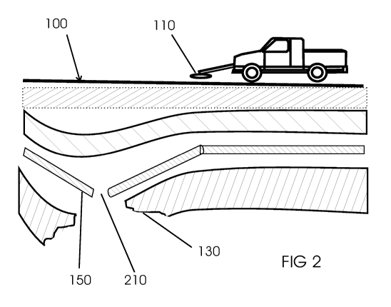
[0065] FIG. 2 shows a side view of the method and apparatus shown in FIG. 1
along section line
2-2. A fabric 150 is built into the road 100 foundation during road
construction or rebuilding.
When a subsurface weakness or cavity 130 develops, said fabric tears 210 or is
otherwise
damaged. This damage or tear in the fabric 210 can be detected easily and
inexpensively using
the above-road sensor assembly 110.
[0066] FIG. 3 shows a cross section of a typical road 301 built with a
flexible pavement
according to modern design. Such a road will have a variable number of layers
and sublayers,
depending on the purpose and geographic location of the road. The surfacing
may include a base
course 300 and a wearing course 310. Both the roadbase 320 and the subbase 330
may comprise
one or several sublayers. Finally, the subgrade is the earth which supports
the road. A road with
rigid pavement will be approximately the same except that the surfacing is
replaced by a
11
CA 02975584 2017-08-01
WO 2015/116547
PCT/US2015/012971
concrete slab.
[0067] FIG. 4 shows a cross section of road 401, similar to road 301, but with
the fabric 150
added. The fabric 150 comprises a regular array of electronic circuits or
devices, from which
potential for road failure can be inferred. In some instantiations, the fabric
may comprise a
regular array of a plurality of microelectronic devices which can respond to a
radio-frequency
signal, such that damage to the fabric also damages one or more of the
microelectronic devices
to an extent that the device can no longer respond to the radio-frequency
signal. Thus, damage to
the fabric can be detected and potential for road failure can be inferred
therefrom.
[0068] FIG. 5 shows a cross section of a road 501 with rigid pavement
comprising a concrete
slab 500, one or more road courses 510, subbase 530, and fabric 150. The
subbase 530 may
comprise one or several sublayers. The fabric 150 comprises a regular array of
electronic circuits
or devices, from which potential for road failure can be inferred. In some
instantiations, the
fabric may comprise a regular array of a plurality of interconnected wires
which can respond to a
radio-frequency signal at a frequency which matches the prespecified resonant
frequency of the
array of wires, such that damage to the fabric also breaks one or more of the
wires or wire
segments thereby changing the resonant frequency of the damaged region of said
fabric which
includes the broken wire or wire segment. Thus, damage to the fabric 150 can
be detected and
potential for road failure can be inferred therefrom.
[0069] FIG. 6 shows a cross section of a road 501, under which a cavity 130
has appeared.
Under normal conditions, a fabric 150 built into the road 501 will remain in
more-or-less the
same condition as when the road was built. However, when the cavity 130, which
might be an
actual opening or a collapsed abandoned mine shaft or tunnel, or just an
unexpected compression
of the subgrade appears , the road courses 510, below the concrete slab 500 or
other surface
layer (not shown) sag 600 towards said cavity. This reduces the support for
said concrete slab
500. In the near future, said concrete slab is likely to fail, particularly
when subject to a heavy
load. The tear or damage 210 to said fabric can be detected easily and
inexpensively using the
above-road sensor assembly disclosed herein.
[0070] FIG. 7 shows an image of a cavity which appears as an irregular gap 710
against an
otherwise uniform background pattern 720 on a display. The data being gathered
from the
sensors in said sensor assembly and shown on said display are processed in
ways which are well-
12
CA 02975584 2017-08-01
WO 2015/116547
PCT/US2015/012971
known to image processing professionals.
[0071] FIG. 8 shows a detail of a fabric which is the first embodiment. RFID
tags 810 are
arranged in the fabric in such a way that adjacent tags do not touch each
other. In other words,
adjacent RFID tags are not in electrical contact with each other. Physically,
an RFID tag
includes a head, where the electronics are, and a tail, or antenna, which is
really just a piece of
wire or other conductive material to receive and transmit radio waves. Each of
the tags has a tail,
or antenna 820, which extends along said fabric. Thus, a fabric tear or damage
breaks 830 the
antennas of some RFID tags and therefore renders some of said RFID tags
inoperable.
[0072] FIG. 9 shows a block diagram for one possible implementation of a
sensor assembly to
be used with said fabric. An array 110 of sensors 120 produces measurements
which are
converted to digital form using conventional analog-to-digital converters
(A/D, 920), and made
available to a multiplexor (MUX, 930). A microprocessor or other computer 940
with associated
memory collects said measurements in sequence. The computer 940 may be
implemented in a
number of different forms. For example, it may be implemented as a cellular
telephone. It may
also be implemented as part of a smart phone, personal digital assistant, a
computer tablet, or
other similar mobile device, or a laptop or personal computer (PC), or as an
embedded system.
One set of measurements constitutes one line of data across a road. Each such
line is tagged with
exact time and location from a location sensor such as a geographic
positioning system receiver
(GPS, 960) or the like and saved to a disk file 950 or the like for later
processing and/or
displayed as one line of an image on a display 970 and/or used to warn the
operator of said
sensor assembly by triggering an alarm 980 or other indicium.
[0073] In some implementations, the sensor assembly for examining the
condition of a road by
detecting a physical integrity of an embedded fabric, comprises a linear
sensor array, a means to
move the linear sensor array along the road so that the array of sensors is
deployed across the
road while being moved along the road, and remotely located signal processing
hardware and/or
software at some other location, so that more extensive processing or less
expensive sensor
assemblies may be used. The linear sensor array may be a predetermined number
of radio
frequency transmitter and receiver pairs which form sensors whose
characteristics match the
electrical characteristics of the embedded fabric. The means to move the array
along the road
may be a vehicle or the like. The signal processing hardware and software
collects and
accumulates data from the array of radio frequency devices. Thus, defects in
or beneath the road
13
CA 02975584 2017-08-01
WO 2015/116547
PCT/US2015/012971
can be discovered. The sensor array apparatus may include some signal
processing hardware and
software which are mounted in or on the vehicle or other means of moving the
array in addition
to the remotely located signal processing hardware and/or software. The
operator of the vehicle
may be immediately alerted to road problems via the hardware and software
mounted in or on
the vehicle. In some implementations, the sensor array is mounted in or on the
vehicle or other
means of moving the array and data is recorded or transmitted to the signal
processing hardware
and software at some other location, whereby more extensive processing or less
expensive
sensor assemblies may be used.
[0074] FIG. 10 shows a flow chart for one possible implementation of software
for a sensor
assembly to be used with the fabric disclosed herein. Said software comprises
an infinite cycle in
which it first gets time and location data 1020. For each sensor in an array
which is transverse to
the travel direction said software then obtains measured sensor data 1030,
checks to see whether
said data indicates a damaged fabric 1040, and stores this information in a
line buffer 1050
memory. After all sensors in said array have been processed 1060 said software
may write said
line buffer contents to disk 1070 and/or append said line buffer contents to
an on-going display
1080 and/or produce an alert in some other way. All above-listed steps are
then repeated.
[0075] All of the following items are available off-the-shelf and in
customized versions from
electronics suppliers, and are not described in detail here: RFID tags, RFID
sensors, radio
frequency transmitters and receivers, analog-to-digital converters,
multiplexors, and
microprocessor components and systems. Free and open-source software available
for image
processing includes OpenCV from Intel Corporation, and OpenGL from
OpenGL.org.
[0076] In some implementations, the condition of the lower layers of a road is
determined by
passing a linear array of RFID sensors along the surface of said road. As said
sensors pass over
RFID tags embedded in said road, only RFID tags which are not damaged will
respond. Thus, as
shown in FIG. 7, a matrix 720 of data points is derived which reveals which
RFID tags are
inoperable.
[0077] FIG. 11 shows a detail of a fabric which is another embodiment. Wires
1110 which
make up said fabric are arranged in a mesh, wherein said wires are
electrically connected at each
intersection 1120. Each set of wire segments and connections forms a loop 1130
with a specific
resonant frequency. When said loops are intact they will resonate and absorb
energy at a
14
CA 02975584 2017-08-01
WO 2015/116547
PCT/US2015/012971
prespecified intended frequency when a radio frequency transmitter is in
operation close to said
loop. Said energy absorption can be detected using well-known methods. When
one or more
wires have been broken 1140 as a result of damage to said fabric, the
remaining wires form
broken loops 1150 that will no longer resonate and absorb energy at the
prespecified intended
frequency. This is a principle well known to radio amateurs and others in the
field.
[0078] In this embodiment, the condition of the lower layers of a road is
determined by passing a
linear array of radio frequency transmitters along the surface of said road.
As said transmitters
pass over the loops, only those loops which are not damaged will respond at
the prespecified
resonant frequency. Thus, as shown in FIG. 7, a matrix 710 of data points is
derived which
reveals which wires have been broken.
[0079] The early warning system disclosed herein provides a method and
apparatus for real-time
monitoring and detection of subsurface failures of a road, highway, airport
runway, railway
track, river or ocean dike, or similar construction which is earth supported.
[0080] Deterioration of subsurface structure of a road can lead to
unanticipated collapse of said
road, which in turn causes expenses to perform emergency repairs, economic
losses due to traffic
rerouting, possible destruction of property, injury to people or animals, and
even death.
[0081] Implementations of the early warning system disclosed herein makes it
possible to
monitor road conditions so that possible collapse can be discovered and
planned for. This is a
need which has been identified as high priority by the Transportation Research
Board of the
National Academies , Automated Sensing for Construction Quality Monitoring of
Concrete
Pavements, and Smart Long-Term Tagging System, Transportation Research Board
(TRB)
Research Needs Statement, [online] 2013, [retrieved on approximately 2013-12-
31] retrieved
from the Internet <URL: rns.trb.org/dproject.asp?n=33481>. Furthermore, it is
a capability
which is not met by prior art.
[0082] Collection, processing, and presentation of sensor array data are well-
known in the
industry. The arrangements in FIG. 10 and FIG. 11 are only intended to show
one way that such
processing could be done. Furthermore, although FIG 7, FIG 8, and FIG 11 show
square arrays,
the arrays need not be square and could be other shapes such as rectangular,
triangular, or
hexagonal.
CA 02975584 2017-08-01
WO 2015/116547
PCT/US2015/012971
[0083] Thus, various implementations of the systems and methods described here
can be
realized in digital electronic circuitry, integrated circuitry, specially
designed ASICs (application
specific integrated circuits), computer hardware, firmware, software, and/or
combinations
thereof These various implementations can include implementation in one or
more computer
programs that are executable and/or interpretable on a programmable system
including at least
one programmable processor, which may be special or general purpose, coupled
to receive data
and instructions from, and to transmit data and instructions to, a storage
system, at least one
input device, and at least one output device.
[0084] These computer programs (also known as programs, software, software
applications or
code) include machine instructions for a programmable processor, and can be
implemented in a
high-level procedural and/or object-oriented programming language, and/or in
assembly/machine language.
[0085] To provide for interaction with the user, the systems and techniques
described here can
be implemented on a computer with or without a display device (e.g., a CRT
(cathode ray tube)
or LCD (liquid crystal display) monitor) for displaying information to the
user and with or
without a keyboard and a pointing device (e.g., a mouse or a trackball) by
which the user can
provide input to the computer. Other kinds of devices can be used to provide
for interaction with
the user as well; for example, feedback provided to the user can be any form
of sensory feedback
(e.g., visual feedback, auditory feedback, or tactile feedback); and input
from the user can be
received in any form, including acoustic, speech, or tactile input.
[0086] The systems and methods described here can be implemented in a
computing system that
includes a back end component (e.g., as a data server), or that includes a
middleware component
(e.g., an application server), or that includes a front end component (e.g., a
client computer
having a graphical user interface or a Web browser through which the user can
interact with an
implementation of the systems and techniques described here), or any
combination of such back
end, middleware, or front end components. The components of the system can be
interconnected
by any form or medium of digital data communication (e.g., a communication
network).
Examples of communication networks include a local area network ("LAN"), a
wide area
network ("WAN"), and the Internet.
16
CA 02975584 2017-08-01
WO 2015/116547
PCT/US2015/012971
[0087] The computing system can include clients and servers. A client and
server are generally
remote from each other and typically interact through a communication network.
The
relationship of client and server arises by virtue of computer programs
running on the respective
computers and having a client-server relationship to each other.
[0088] In addition, the logic flows depicted in FIG. 10 do not require the
particular order shown,
or sequential order, to achieve desirable results. In addition, other steps
may be provided, or
steps may be eliminated, from the described flows, and other components may be
added to, or
removed from, the described systems. Accordingly, other implementations are
within the scope
of the following claims.
[0089] It will be appreciated that the above implementations that have been
described in
particular detail are merely examples or possible implementations, and that
there are many other
combinations, additions, or alternatives that may be included.
[0090] Further, systems described herein may be implemented via a combination
of hardware
and software, as described, or entirely in hardware elements. Also, the
particular division of
functionality between the various system components described herein is merely
example, and
not mandatory; functions performed by a single system component may instead be
performed by
multiple components, and functions performed by multiple components may
instead performed
by a single component.
[0091] Some portions of the above description present features in terms of
algorithms and
symbolic representations of operations on information. These algorithmic
descriptions and
representations may be used by those skilled in the data processing arts to
most effectively
convey the substance of their work to others skilled in the art. These
operations, while described
functionally or logically, are understood to be implemented by computer
programs. Furthermore,
it has also proven convenient at times, to refer to these arrangements of
operations as modules or
by functional names, without loss of generality.
[0092] Unless specifically stated otherwise as apparent from the above
discussion, it is
appreciated that throughout the description, discussions utilizing terms such
as "processing" or
"computing" or "calculating" or "determining" or "displaying" or "providing"
or the like, refer to
the action and processes of a computer system, or similar electronic computing
device, that
17
CA 02975584 2017-08-01
WO 2015/116547
PCT/US2015/012971
manipulates and transforms data represented as physical (electronic)
quantities within the
computer system memories or registers or other such information storage,
transmission or
display devices.
[0093] Based on the foregoing specification, the above-discussed
implementations may be
implemented using computer programming or engineering techniques including
computer
software, firmware, hardware or any combination or subset thereof. Any such
resulting program,
having computer-readable and/or computer-executable instructions, may be
embodied or
provided within one or more computer-readable media, thereby making a computer
program
product, i.e., an article of manufacture. The computer-readable media may be,
for instance, a
fixed (hard) drive, diskette, optical disk, magnetic tape, semiconductor
memory such as read-
only memory (ROM) or flash memory, etc., or any transmitting/receiving medium
such as the
Internet or other communication network or link. The article of manufacture
containing the
computer code may be made and/or used by executing the instructions directly
from one
medium, by copying the code from one medium to another medium, or by
transmitting the code
over a network.
[0094] While the disclosure has been described in terms of various specific
implementations,
instantiations and embodiments, it will be recognized that the disclosure can
be practiced with
modification within the spirit and scope of the claims.
18