Note: Descriptions are shown in the official language in which they were submitted.
CA 02979206 2017-09-08
WO 2015/138913 PCT/US2015/020464
FACILITY AND INFRASTRUCTURE UTILIZATION
BACKGROUND
[0001] Typical transportation analysis focuses on the efficient movement of
goods
and services throughout the transportation network. This transportation
analysis may include
fuel utilization, an analysis of vehicle and driving behavior, or route
optimization. While
transportation analysis is maturing, solutions are not readily available to
analyze facilities
surrounding or supporting the transportation network.
SUMMARY
[0002] This invention focuses on facility utilization, leveraging available
information
from infrastructure, from vehicle movements, and from other sources of
information to
determine usage characteristics of one or more facilities. Understanding the
utilization of
facilities is important to optimize the placement of parking facilities, to
assess an appropriate
value for parking, to understand the utilization of specific road segments or
intersections, and
other key facilities. A facility-based approach is important to fully
understand the impact of
transportation not just on the vehicle and the road network, but also key
interactions between
facilities and vehicles.
[0003] One example of a facility utilization system includes a plurality of
vehicles
with telematics systems. A server receives telematics information from the
plurality of
vehicles, including location information of each of the plurality of vehicles.
The server
compares the location information to a location of at least one facility to
determine facility
utilization. The server monitors utilization of the at least one facility
based upon the
comparison of the location information of the plurality of vehicles to the
location of the at
least one facility.
BRIEF DESCRIPTION OF THE DRAWINGS
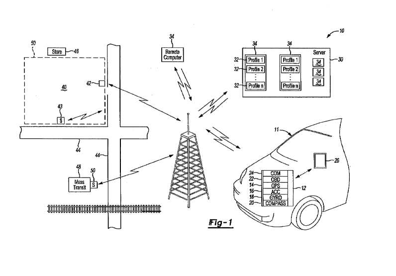
[0004] Figure 1 is a schematic of one embodiment of the present invention.
DETAILED DESCRIPTION OF A PREFERRED EMBODIMENT
[0005] Figure 1 is a schematic of a facility and infrastructure utilization
monitoring
system 10 according to one embodiment of the present invention. A motor
vehicle 11
includes a plurality of data gathering devices that communicate information to
a telematics
appliance 12 installed within the vehicle 11. The example data gathering
devices include a
global positioning satellite (GPS) receiver 14, a three-axis accelerometer 16,
a gyroscope 18
and an electronic compass 20, which could be housed within the appliance 12
(along with a
1
CA 02979206 2017-09-08
WO 2015/138913 PCT/US2015/020464
processor and suitable electronic storage, etc. and suitably programmed to
perform the
functions described herein). As appreciated, other data monitoring systems
could be utilized
within the contemplation of this invention. Data may also be collected from an
onboard
diagnostic port (OBD) 22 that provides data indicative of vehicle engine
operating parameters
such as vehicle speed, engine speed, temperature, fuel consumption (or
electricity
consumption), engine idle time, car diagnostics (from OBD) and other
information that is
related to mechanical operation of the vehicle. Moreover, any other data that
is available to
the vehicle could also be communicated to the appliance 12 for gathering and
compilation of
the operation summaries of interest in categorizing the overall operation of
the vehicle. Not
all of the sensors mentioned here are necessary, however, as they are only
listed as examples.
The GPS receiver 14 may be sufficient by itself.
[0006] The appliance 12 may also include a communication module 24 (such as
cell
phone, satellite, wi-fl, etc.) that provides a connection to a wide-area
network (such as the
internet). Alternatively, the communication module 24 may connect to a wide-
area network
(such as the internet) via a user's cell phone 26 or other device providing
communication.
[0007] The in vehicle appliance 12 gathers data from the various sensors
mounted
within the vehicle 11 and stores that data. The in vehicle appliance 12
transmits this data (or
summaries or analyses thereof) as a transmission signal through a wireless
network to a
server 30 (also having at least one processor and suitable electronic storage
and suitably
programmed to perform the functions described herein). The server 30 utilizes
the received
data to categorize vehicle operating conditions in order to determine or track
vehicle use.
This data can be utilized for tracking and determining driver behavior,
insurance premiums
for the motor vehicle, tracking data utilized to determine proper operation of
the vehicle and
other information that may provide value such as alerting a maintenance depot
or service
center when a specific vehicle is in need of such maintenance. Driving events
and driver
behavior are recorded by the server 30, such as fuel and/or electricity
consumption, speed,
driver behavior (acceleration, speed, etc.), distance driven and/or time spent
in certain
insurance-risk coded geographic areas. The on-board appliance 12 may collect
and transmit
to the server 30 (among other things mentioned herein): Speed, Acceleration,
Distance, Fuel
consumption, Engine Idle time, Car diagnostics, Location of vehicle, Engine
emissions, etc.
[0008] The server 30 includes a plurality of profiles 32, each associated with
a vehicle
11 (or alternatively, with a user). Among other things, the profiles 32 each
contain
information about the vehicle 11 (or user) including some or all of the
gathered data (or
summaries thereof). Some or all of the data (or summaries thereof) may be
accessible to the
2
CA 02979206 2017-09-08
WO 2015/138913 PCT/US2015/020464
user via a computer 34 over a wide area network (such as the internet) via a
policyholder
portal, such as fuel efficiency, environmental issues, location, maintenance,
etc. The user can
also customize some aspects of the profile 32.
[0009] It should be noted that the server 30 may be numerous physical and/or
virtual
servers at multiple locations. The server 30 may collect data from appliances
12 from many
different vehicles 11 associated with a many different insurance companies.
Each insurance
company (or other administrator) may configure parameters only for their own
users. The
server 30 permits the administrator of each insurance company to access only
data for their
policyholders. The server 30 permits each policyholder to access only his own
profile and
receive information based upon only his own profile.
[0010] The server 30 may not only reside in traditional physical or virtual
servers, but
may also coexist with the on-board appliance, or may reside within a mobile
device. In
scenarios where the server 30 is distributed, all or a subset of relevant
information may be
synchronized between trusted nodes for the purposes of aggregate statistics,
trends, and geo-
spatial references (proximity to key locations, groups of drivers with similar
driving routes).
[0011] The present invention described below can be implemented with the
system 10
described above or variations thereof. The present invention can be
implemented with
existing telematics systems, particularly fleet telematics systems, with the
additional
functions described below.
[0012] The system 10 analyzes facility and infrastructure utilization, such as
a
parking lot 40 for vehicles such as vehicle 11. Ideally, all vehicles in a
fleet or all (or nearly
all) vehicles in a geographic area would be equipped like vehicle 11.
Alternatively, analysis
can be performed based upon a sampling of vehicles if only a percentage of
vehicles in the
area are equipped with telematics like vehicle 11. This information can be
augmented by
other sensors, such as an entry control system 42 (e.g. gate) at the parking
lot 40. The entry
control system 42 is equipped with sensors and communication capability to be
able to
monitor vehicles entering and leaving the parking lot 40 and send this
information to the
server 30. The parking lot 40 may also have a parking payment system 43 which
is in
communication with the server 30. The parking payment system 43 may be of the
type
where a user pays for a particular spot in the parking lot 40 by credit card
or electronic
account payment. The parking lot 40 may also have cameras or other sensors for
monitoring
the level of occupancy. The parking lot 40 is adjacent roads 44 and accessible
from at least
one of the roads 44.
3
CA 02979206 2017-09-08
WO 2015/138913 PCT/US2015/020464
[0013] At least one destination 46, such as a store, gym, etc is proximate the
parking
lot 40. The parking lot 40 is close enough to the at least one destination
that there is a high
likelihood that vehicles 11 parked in the parking lot 40 belong to people who
are visiting the
destinations.
[0014] The parking lot 40 may also be proximate a mass transit station 48,
such as a
bus stop or train station. The transit station 48 is associated with a server
50 (which may or
may not be located on-site) that contains the schedule for arriving and
departing mass transit
carriers, such as busses, trains, etc. The schedule is sent to the server 30.
Alternatively, or
additionally, actual information indicating actual arrival and departure times
of the mass
transit carriers could be sent to the server 30.
[0015] By monitoring the telematics information from the vehicles 11, the
system 10
collects, analyzes, and reports on utilization information for one or more
facilities such as the
parking lot 40. The facility may be the parking lot 40 but may also be a
roadside parking
spot, a house, shopping center, gas station, drive-through, or a building. The
parking lot 40,
or other facility, may be defined by a geo-fence 50, so when a vehicle 11 is
located within the
geo-fence 50, the vehicle 11 is considered to be in the parking lot 40. The
location of the
vehicle 11 may be sent from the appliance 12 to the server 30, where the
server 30 compares
the vehicle 11 location to the geo-fence 50. Alternatively, the geo-fence 50
may be stored
locally on the appliance 12 and the location of the vehicle 11 is only sent to
the server 30
when the appliance determines its presence in the parking lot 40.
[0016] The system 10 may further derive usage statistics describing usage of
defined
parking locations, including but not limited to, turnover rates and parking
duration. Factors
included in the statistical model may include time of day, day of week,
weather conditions,
road network changes (road closures, detours), and special events in close
proximity to the
facility.
[0017] Usage statistics may be derived based on monitoring vehicle 11
movements,
integrating information from parking reservation systems, integrating
information from
parking payment systems 43, and/or integrating information from infrastructure
occupancy
sensors.
[0018] Usage statistics may describe facility utilization based on the origin
of
vehicles 11. The origin may be approximated using a general direction, such as
"from the
east," "from the west," "from the south," or "from the north," or with local
geography
references "from downtown," or "from the east-end." The origin may be
automatically
classified as a home, work, or other contextually relevant location class.
4
CA 02979206 2017-09-08
WO 2015/138913 PCT/US2015/020464
[0019] The facility utilization statistics may be based on the demographic,
sociographic, and/or psychographic characteristics of the occupant(s) in each
vehicle. By
analyzing origin-destination patterns, telematics from the appliance 12 in the
vehicle 11,
and/or parking reservation systems (most require registration with additional
details), the
server 30 can infer some demographic and psychographic information.
Psychographic
information includes interests (i.e. does the vehicle frequent a bulk-food
store?) and lifestyle
(i.e. does this vehicle regularly visit a gym facility?). Inferring this
information about
vehicles 11 in a parking lot is valuable for shopping centers / retail and
urban planning
activities around the parking lot 40 itself.
[0020] The system 10 may also correlate facility utilization with alternate
modes of
transportation, including linking the parking lot 40 with the nearby transit
station 48. By
linking into bus or train arrival and departure times from server 50, and
their proximity to the
parking lot 40, and comparing the arrival and/or departure times of the
vehicles 11 with the
departure/arrival times of the mass transit, hypotheses can be formed about
the intended use
of the parking lot 40. For example, vehicles 11 arriving shortly before train
or bus departure,
then leaving shortly after train or bus returns are likely used for commuting.
If a parking lot
40 is used primarily to host vehicles 11 while the occupants are traveling on
the bus or train,
it can be valuable to offer combined parking & train fares, or to revisit the
purpose of the
parking lot 40 to optimize value, incentives, or revenues generated by the
parking lot 40.
[0021] The facility may be a portion of the road network or real-estate,
including but
not limited to an intersection of roads 44, a defined geographic boundary, or
a road 44
segment of interest.
[0022] The facility may be a bus, train, subway, taxi, or other means of
transport in
which utilization is measured in part based on occupancy. Occupancy in mass
transit can be
performed by cameras or other sensors.
[0023] The system 10 may assess a static or dynamic usage-based charge (e.g.
through the user profile 34, such as a credit card stored in the profile 34)
for use of the facility
based on one or more factors including duration, arrival time, departure time,
day of week,
special events, vehicle type, vehicle mass, facility congestion/availability,
and/or linkage with
alternate modes of transportation (bus, train, subway, carpool, etc.). Vehicle
11 type and
mass is determined from the VIN. The VIN is read by the appliance 12.
Duration, arrival
time, departure time, day of week relies on an accurate clock reference.
Special events are
updated manually ¨ typically relevant for modern parking reservation systems.
Linkage with
mass transit 48 can be determined if the driver used a parking reservation
system (or inferred
CA 02979206 2017-09-08
WO 2015/138913 PCT/US2015/020464
based on correlation of bus/train arrival/departure and vehicle activity, as
explained above).
All of this information can be used to calculate a fair and individualized
charge for each
vehicle using the facility.
[0024] The server 30 may predict facility usage based on historical statistics
and
observed context, including upcoming special events, road network changes
(closures,
detours), weather conditions, time of day, day of week, and/or season.
[0025] The system 10 may provide personalized notification to travelers during
journey planning, while in transit searching for a facility of interest, or
directly to travelers in
close proximity to the facility using traditional infrastructure notification
or remote
communication methods to reach the traveler. The system 10 may also analyze
asset
utilization including facility based information about the presence, absence,
and asset
location within the facility.
[0026] The system 10 may generate transaction reports identifying the movement
of
vehicles 11 in and out of each facility (i.e. each transaction includes:
parking lot, vehicle,
date/time, in/out). The system 10 may generate parking reports describing
parking behavior
of each vehicle 11 (i.e. each entry includes: parking lot, vehicle, date/time
arrival in lot,
parking duration, departure from lot). The system 10 may generate departure
reports
describing the absence of each vehicle 11 from the facility (i.e. each entry
includes: parking
lot, vehicle, date/time departure from lot, time away from lot, arrival in
lot). The system 10
may also generate parking lot usage reports summarizing each vehicle 11 in
each facility (i.e.
each entry includes: parking lot, vehicle, total time in lot, total time away
from lot, last
parking time, last departure time).
[0027] In accordance with the provisions of the patent statutes and
jurisprudence,
exemplary configurations described above are considered to represent a
preferred
embodiment of the invention. However, it should be noted that the invention
can be
practiced otherwise than as specifically illustrated and described without
departing from its
spirit or scope.
6