Note: Descriptions are shown in the official language in which they were submitted.
CA 02984302 2017-10-27
WO 2016/176114 PCT/US2016/028740
- 1 -
METHOD AND SYSTEM FOR DETERMINING AND DISSEMINATING
STANDARDIZED AGGREGATED MEASUREMENTS OF ACTIVITY
FIELD
[0001]The present disclosure relates to the generating of indices of activity
for
geographic areas, specifically the use of weighting values and a geographic
grid to
generate index values for activity in geographic areas across the geographic
grid.
BACKGROUND
[0002]The measurement of activity in a geographic area can be beneficial for
any
number of entities across any number of industries. For example, merchants may
be
highly interested in the activity of consumers conducting payment transactions
to
identify new marketing plans or location expansion. In another example, law
enforcement may be interested in criminal activity in an area to develop new
patrols
and coverage to help combat crime. In yet another example, mobile network
operators may be interested in cellular phone usage in an area to determine
where
to place additional towers to increase network coverage and strength.
[0003]However, the measuring of such activity can often be very difficult, if
not
impossible, to achieve, particularly when associating the measured activity
with a
specific geographic area. In many instances, such information may often be
unavailable, or may be inaccessible for entities due to privacy concerns. By
associating activity with a specific geographic location, the activity may be
personally
identifiable to a specific individual or business in instances where only that
specific
individual or business is located at the geographic location. For example, if
criminal
activity is being measured, and criminal activity is shown in a rural area
where only a
single individual lives, then that individual is singled out as being
associated with the
criminal activity, which may be undesirable for a measuring entity, a
violation of
privacy for the single individual (e.g., especially if that individual is a
victim of a
crime), and, in some instances, may even be against rules or regulations.
[0004]Thus, there is a need for a technical solution where activity can be
measured
for geographic areas without sacrificing individual privacy. Current systems
lack the
CA 02984302 2017-10-27
WO 2016/176114 PCT/US2016/028740
- 2 -
ability to handle sensitive data and to do so in a way that retains privacy of
entities
associated with the data, while also maintaining a high level of accuracy for
measurement of activity. In addition, current systems lack methods for
obscuring or
otherwise modifying the data to maintain entity privacy while still adequately
measuring activity. Further, existing systems also often measure activity with
respect to geographic areas that are inconsistent in size and shape, such as
based
on municipality boundaries, which may result in inconsistencies in activity
measurements, as well as provide less usefulness for the data. Accordingly,
there is
a need for a technical solution that can measure activity in a geographic area
that
uses indices and weight values to protect entity privacy while maintaining a
high
level of accuracy and data usability.
SUMMARY
[0005]The present disclosure provides a description of systems and methods for
generating indices of activity for geographic areas.
[0006]A method for generating indices of activity for geographic areas
includes:
receiving, by a receiving device, a plurality of activity values, wherein each
activity
value is associated with an entity and a geographic location; identifying, by
a
processing device, a geographic grid, wherein the geographic grid includes a
plurality of geographic areas, each geographic area being of an equal size and
including (i) no geographic locations associated with an activity value or
(ii) two or
more geographic locations associated with an activity value; calculating, by
the
processing device, a weight value for each geographic area in the identified
geographic grid, wherein the weight value is based on at least (i) a first
weight factor
applied to each activity value associated with a geographic location included
in the
respective geographic area and (ii) a second weight factor applied to each
activity
value associated with a geographic location included in an adjacent geographic
area;
calculating, by the processing device, an index value for each geographic area
in the
identified geographic grid, wherein the index value is based on at least the
calculated
weight value for the respective geographic area and an average weight value
for
each geographic area in the identified geographic grid; and transmitting, by a
transmitting device, at least the calculated index value for one or more
geographic
areas of the plurality of geographic areas included in the identified
geographic grid.
CA 02984302 2017-10-27
WO 2016/176114 PCT/US2016/028740
- 3 -
[0007]A system for generating indices of activity for geographic areas
includes a
receiving device, a processing device, and a transmitting device. The
receiving
device is configured to receive a plurality of activity values, wherein each
activity
value is associated with an entity and a geographic location. The processing
device
is configured to: identify a geographic grid, wherein the geographic grid
includes a
plurality of geographic areas, each geographic area being of an equal size and
including (i) no geographic locations associated with an activity value or
(ii) two or
more geographic locations associated with an activity value; calculate a
weight value
for each geographic area in the identified geographic grid, wherein the weight
value
is based on at least (i) a first weight factor applied to each activity value
associated
with a geographic location included in the respective geographic area and (ii)
a
second weight factor applied to each activity value associated with a
geographic
location included in an adjacent geographic area; and calculate an index value
for
each geographic area in the identified geographic grid, wherein the index
value is
based on at least the calculated weight value for the respective geographic
area and
an average weight value for each geographic area in the identified geographic
grid.
The transmitting device is configured to transmit at least the calculated
index value
for one or more geographic areas of the plurality of geographic areas included
in the
identified geographic grid.
BRIEF DESCRIPTION OF THE DRAWING FIGURES
[0008]The scope of the present disclosure is best understood from the
following
detailed description of exemplary embodiments when read in conjunction with
the
accompanying drawings. Included in the drawings are the following figures:
[0009]FIG. 1 is a block diagram illustrating a high level system architecture
for
generating indices of activity for geographic areas in accordance with
exemplary
embodiments.
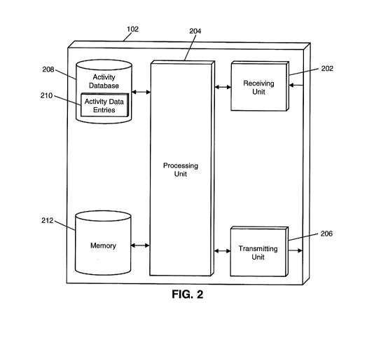
[0010]FIG. 2 is a block diagram illustrating the processing server of FIG. 1
for
generating indices of activity for geographic areas in accordance with
exemplary
embodiments.
[0011]FIG. 3 is a flow diagram illustrating a process generating indices of
activity for
geographic areas using the processing server of FIG. 2 in accordance with
exemplary embodiments.
CA 02984302 2017-10-27
WO 2016/176114 PCT/US2016/028740
- 4 -
[0012]FIGS. 4A-4C are diagrams illustrating the generating of indices of
activity for
geographic areas using weighting values in accordance with exemplary
embodiments.
[0013] FIG. 5 is a flow chart illustrating an exemplary method for generating
indices
of activity for geographic areas in accordance with exemplary embodiments.
[0014] FIG. 6 is a block diagram illustrating a computer system architecture
in
accordance with exemplary embodiments.
[0015] Further areas of applicability of the present disclosure will become
apparent
from the detailed description provided hereinafter. It should be understood
that the
detailed description of exemplary embodiments are intended for illustration
purposes
only and are, therefore, not intended to necessarily limit the scope of the
disclosure.
DETAILED DESCRIPTION
System for Generating Indices of Activity for Geographic Areas
[0016] FIG. 1 illustrates a system 100 for the generating of indices of
activity for
geographic areas.
[0017]The system 100 may include a processing server 102. The processing
server
102, discussed in more detail below, may be configured to generate indices of
activity for geographic areas. The indices of activity may be generated by
applying
weighting values to a geographic grid used for association with measured
activity.
The indices of activity may be requested by a data requestor 104. The data
requestor 104 may be an entity desiring the indices for a specific activity,
and may
be a third party entity, a user of a computing system comprised of or
including the
processing server 102, etc. For example, the data requestor 104 may be a
merchant
requesting activity regarding consumer transactions in a specific merchant
industry.
[0018] The system 100 may also include a data provider 106. The data provider
106
may provide the processing server 102 with activity data for use in generating
the
indices of activity. The activity data typically includes a descriptor of the
activity,
preferably in a standardized form, and a geographic location assigned to the
activity
(e.g., the longitude and latitude of a point of sale used in a purchase of a
specified
product). The geographic location might be in the form of longitude and
latitude,
perhaps down to the minute or second, as determined by a device at the
location via
CA 02984302 2017-10-27
WO 2016/176114 PCT/US2016/028740
- 5 -
known GPS, cellular or WiFi or other geolocation determination techniques, or
by a
look-up data base of assigned locations (e.g., by the identification code of a
point of
sale (POS) terminal involved in a transaction that is transmitted with a
transaction
authorization request for example). Alternatively, other techniques can be
used,
such as assigned addresses, governmental boundaries and even zip-plus four
postal
codes, so long is there is not significant ambiguity in grid assignment due to
overlapping boundaries between the grid and the geolocation determination
mechanism chosen and the grid that is assigned to the geolocation for a given
purpose. That is, if a grid would encompass a number of postal codes, only
some of
which extended outside the particular grid, using same might be sufficient for
a given
purpose. That said, using longitude and latitude for a geolocation can provide
a
technical advantage in that a simple comparison of the specific values to
determine
whether they are in the range of a specific grid would be computationally less
intensive that determining the sometimes irregular boundary of a
governmentally
determined area. The data provider 106 may be a data collection agency,
research
firm, credit bureau, or any other suitable type of entity. In some
embodiments, the
data provider 106 may be the data requestor 104, such as in an instance where
the
data requestor 104 may want interpretation and analysis of data offered by the
processing server 102. For example, a merchant requesting activity regarding
consumer transactions in a specific merchant industry may collect available
transaction data to provide to the processing server 102 for analysis and
generation
of indices. In some instances, the processing server 102 may request the
activity
data from a suitable data provider 106 after receiving a data request from the
data
requestor 104. For instance, in the above example, the processing server 102
may
request transaction data from payment networks, transaction aggregators, or
another
suitable data provider 106 for consumer transactions in the specific merchant
industry requested by the merchant data requestor 104.
[0019]The processing server 102, as discussed in more detail below, may
identify a
geographic grid for the measured activity. The geographic grid may include a
plurality of geographic areas of equal size where each geographic area
includes
either no geographic locations associated with measured activity or at least
two
geographic locations associated with measured activity. By creating the grid
such
that each area includes at least two activity locations, or none, may ensure
that no
CA 02984302 2017-10-27
WO 2016/176114 PCT/US2016/028740
- 6 -
measurement of activity can be identifiable to a specific individual or
entity, as the
activity is split among at least two entities in that geographic area. For
example, the
level of granularity may be adjusted to ensure that each geographic area in
the grid
includes a sufficient number of geographic locations. For instance, a
geographic grid
for one area or activity may use areas of one square kilometer for example
perhaps
where population and/or activity is comparatively dense (e.g., New York City),
while
a geographic grid for another area or activity may use areas of ten square
kilometers
for example perhaps where population and/or activity is comparatively sparse
(e.g.,
Montana). In some instances, a higher number of activity locations may be
included
in each geographic area, and may vary depending on the type of activity
measured
and the value of measurements. For example, the number of activity locations
may
be higher for criminal activity than for cellular phone usage.
[0020]In some instances, the area of each section of the geographic grid may
be
determined based on the geographic locations, such that each grid section
includes
either no geographic locations or at least a predetermined number of
geographic
locations associated with measured activity (e.g., five). In other instances,
the area
of each section may be predetermined (e.g., one square kilometer). In such an
instance, if each section does not include either no geographic locations or
the
predetermined number of geographic locations, the methods and systems
discussed
herein may combine sections for use in performing the disclosed methods, such
that
the section that is used in the calculations and determinations discussed
below
includes at least the predetermined number of geographic locations. For
example, if
a section of the geographic grid includes only a single geographic location
associated with the measured activity, the surrounding sections may also be
included in the calculations discussed herein. If the section and surrounding
sections combined still does not include the predetermined number of
locations, the
further surrounding sections may also be included, and so on, until a suitable
level of
privacy and security is obtained.
[0021]Once the grid has been identified, the processing server may calculate
weight
vales for each area in the grid. The weight values may be calculated based on
application of a series of two or more weight factors to an activity value for
each area
in the geographic grid. The weight factors may be, as discussed in more detail
below, values that are applied to the activity value in each area and/or
activity values
CA 02984302 2017-10-27
WO 2016/176114 PCT/US2016/028740
- 7 -
in surrounding geographic areas. For example, the activity value in a specific
area
may be adjusted by a first weight factor, then combined with the result of a
second
weight factor applied to activity values in surrounding areas, and may be
further
combined with the result of a third weight factor applied to activity values
in areas
surrounding the surrounding areas. The use of weight factors and the inclusion
of
activity values from surrounding areas may ensure that the activity values in
a
geographic area are obscured, to preserve security and privacy for associated
entities, while maintaining a high level of accuracy.
[0022] In some embodiments, the value of the weight factors, the number of
weight
factors used, and the applicable geographic areas may all be identified based
on the
type of activity being measured, a level of privacy or security required
(e.g., based on
the activity, requested by the data requestor 104, set by the processing
server 102,
based on rules or regulations, etc.), the activity values, etc. In some
instances, the
processing server 102 may be configured to calculate or otherwise identify the
weight factors used based on one or more criteria, the use of appropriate
rules or
algorithms, etc. For example, the processing server 102 may develop an
algorithm
for calculating weight factors based on a provided level of security and an
average
activity value. In some embodiments, the processing server 102 may repeat the
calculation of weight values using weight factors until suitable weight values
are
identified. Suitable weight values may be weight values that satisfy
requirements for
privacy or security.
[0023] Once weight values are calculated, the processing server 102 may
calculate
an index value for each geographic area. The index value may be based on the
weight value for the geographic area and an average weight value for all of
the
geographic areas in the geographic grid. The index value may then be
associated
with that geographic area and may be provided to the data requestor 104. In
some
embodiments, the processing server 102 may provide the data requestor 104 with
a
list of index values and associated geographic areas. In other embodiments,
the
processing server 102 may generate a representation of the geographic grid
that
includes the geographic areas and the associated index values, such as
illustrated in
FIG. 4C and discussed in more detail below. Additional types of
representations of
index values for geographic areas will be apparent to persons having skill in
the
relevant art.
CA 02984302 2017-10-27
WO 2016/176114 PCT/US2016/028740
- 8 -
[0024]The methods and systems discussed herein may enable the processing
server 102 to generate indices of activity that are highly accurate
representations of
activity for a plurality of geographic areas, while maintaining a high level
of security
and privacy for individuals and entities associated with the activity data.
The use of
weight factors across multiple geographic areas and a specially identified
geographic
grid may ensure that no individual whose activity is considered is personally
identifiable, which may enable the processing server 102 to generate indices
for
types of activity that are currently not measurable without an invasion of
individual
privacy. As a result, the methods and systems discussed herein can provide for
more accurate representations of activity without sacrificing security or
privacy via
the use of specially identified geographic grids, weight factors, and weight
values,
which are unheard of in existing technical systems.
Processing Server
[0025]FIG. 2 illustrates an embodiment of the processing server 102 of the
system
100. It will be apparent to persons having skill in the relevant art that the
embodiment of the processing server 102 illustrated in FIG. 2 is provided as
illustration only and may not be exhaustive to all possible configurations of
the
processing server 102 suitable for performing the functions as discussed
herein. For
example, the computer system 600 illustrated in FIG. 6 and discussed in more
detail
below may be a suitable configuration of the processing server 102.
[0026] The processing server 102 may include a receiving unit 202. The
receiving
unit 202 may be configured to receive data over one or more networks via one
or
more network protocols. The receiving unit 202 may receive activity data from
data
providers 106, and, in some instances, may be specially configured for the
receipt of
data. For instance, the receiving unit 202 may be configured to encrypt data
upon
receipt so that the processing server 102 does not possess any data
potentially
identifiable to an individual or entity. In another example, the receiving
unit 202 may
be specially configured to receive sensitive financial data over payment
rails, such as
may be transmitted using special protocols and data standards, that may be
unavailable to traditional computing systems. The receiving unit 202 may also
be
configured to receive data requests from data requestors 104, which may be
CA 02984302 2017-10-27
WO 2016/176114 PCT/US2016/028740
- 9 -
provided by third party entities and computing systems, or input into the
processing
server 102 via one or more input units.
[0027]The processing server 102 may also include a processing unit 204. The
processing unit 204 may be configured to perform the functions of the
processing
server 102 discussed herein, as will be apparent to persons having skill in
the
relevant art. The processing unit 204 may be configured to identify geographic
areas
and/or geographic grids, identify weight factors, calculate weight values,
calculate
index values, generate representations of geographic grids and index values,
and
other functions discussed herein.
[0028]The processing server 102 may further include a transmitting unit 206.
The
transmitting unit 206 may be configured to transmit data over one or more
networks
via one or more network protocols. The transmitting unit 206 may transmit
calculated index values and/or generated representations of the geographic
grid.
The transmitting unit 206 may also be configured to transmit data requests,
such as
to data providers 106 requesting activity data. Data requests may be generated
by
the processing unit 204 based on a received activity index request and data
stored
therein regarding the requested activity.
[0029]The processing server 102 may also include an activity database 208. The
activity database 208 may be configured to store a plurality of activity data
entries
210. Each activity data entry 210 may include data related to a measured
activity
including at least an activity value and an associated geographic location. In
some
embodiments, each activity data entry 210 may also include an activity
identifier,
which may identify the related activity. In other embodiments, each activity
data
entry 210 may include data related to a specific activity. In such an
embodiment, the
processing server 102 may include separate activity database 208 for separate
activities, or may not retain activity data entries 210 for completed
geographic grids.
In some embodiments, the processing server 102 may not include an activity
database 208 or the activity database 208 may be used for temporary storage
only,
such that any potentially sensitive data is not retained to protect individual
and entity
privacy and security.
[0030] The processing server 102 may further include a memory 212. The memory
212 may be configured to store data suitable for use by the processing server
102 in
performing the functions discussed herein. For example, the memory 212 may
CA 02984302 2017-10-27
WO 2016/176114 PCT/US2016/028740
- 10 -
include rules and algorithms for generating geographic grids, identifying
weight
factors, calculating weight values, calculating index values, generating grid
representations, encrypting received data, receiving and transmitting data,
etc. In
some instances, the memory 212 may also be used to temporarily store received
activity data. Additional data that may be stored in the memory 212 will be
apparent
to persons having skill in the relevant art.
Process for Generating Indices of Activity
[0031] FIG. 3 illustrates a process 300 for generating indices of activity for
geographic areas as performed by the processing server 102.
[0032] In step 302, the receiving unit 202 of the processing server 102 may
receive
activity data (e.g., from a data provider 106) and may receive a map request
(e.g.,
from a data requestor 104). In some embodiments, step 302 may include
receiving
the map request and then transmitting (e.g., by the transmitting unit 206 of
the
processing server 102) an activity request to the data provider 106 prior to
receipt of
the activity data. The activity data may include at least a plurality of
activity values,
with each activity value being associated with a geographic location. The map
request may include a request for indices for a specific type of activity and
for an
identified plurality of geographic areas. The map request may also indicate
the type
of representation requested for the calculated index values.
[0033] In step 304, the processing unit 204 of the processing server 102 may
generate a geographic grid. The geographic grid may include a plurality of
geographic areas encompassing the geographic locations associated with the
received activity data and may each be of equal size and include either no
activity
locations or at least two activity locations. In step 306, the processing unit
204 may
determine if the generated geographic grid has sufficient density of activity
locations.
Sufficient density may be determined by identifying if any entity associated
with an
activity value is identifiable in a geographic area as being directly
associated with
that activity value. If the density is not suitable, then, in step 308, the
processing unit
204 may adjust the size of the geographic areas, such as by expanding them, to
ensure proper density and entity privacy. For example, the processing unit 204
may
increase the level of granularity, such as using the next highest order of
measurement (e.g., from one square kilometer to ten square kilometers, from
using
CA 02984302 2017-10-27
WO 2016/176114 PCT/US2016/028740
- 11 -
coordinate degrees to coordinate minutes, etc.) In some instances, the
processing
unit 204 may combine geographic areas in order to ensure proper density, such
as
by combining a geographic area with its surrounding geographic areas.
[0034] Once a geographic grid has been identified where no entity is
individually
identifiable and privacy and security are maintained, then, in step 310, the
processing unit 204 may identify two or more weight factors. The weight
factors may
be calculated using one or more rules or algorithms, such as stored in the
memory
212 of the processing server 102, and may be based on activity values,
geographic
area densities, the type of activity measured, and other suitable criteria. In
step 312,
the processing unit 204 may calculate weight values for each geographic area
in the
geographic grid. The weight values may be calculated based on application of
each
of the weight factors to the appropriate geographic areas. In step 314, the
processing unit 204 may calculate an index value for each geographic area
based on
the weight value calculated for that geographic area and an average weight
value
calculated for each geographic area in the geographic grid.
[0035] In step 316, the processing unit 204 may determine if the calculated
index
values are sufficient. The index values may be sufficient if the resulting
values are
such that an entity is not individually identifiable as a result of the index
values. In
some instances, sufficiency may also be based on the spread of index values,
such
that the values may be insufficient if every geographic area has values that
are too
close together. In some embodiments, sufficiency of index values may be based
on
criteria set forth by the data requestor 104, such as included in the received
map
request. If the index values are not sufficient, then, in step 318, the weight
factors
may be adjusted to obfuscate or otherwise change the resultant index values to
protect entity privacy and security. For example, if the index values are too
close
together, the first weight factor applied to each geographic area may be
increased
and/or the second weight factor applied to surrounding geographic areas may be
decreased.
[0036] Once the weight factors have been adjusted, the process may return to
step
312, and new weight values and area indices calculated. Once, in step 316, the
processing unit 204 determines that the weight factors have resulted in
sufficient
index values, then, in step 320, the processing unit 204 may generate a
geographic
map. The geographic map may be an illustration of the geographic grid and
included
CA 02984302 2017-10-27
WO 2016/176114 PCT/US2016/028740
- 12 -
geographic areas, including a representation of the associated index values.
For
instance, the geographic map may be a heat map that may show intensity based
on
the index values associated with each geographic area. Additional types of
graphical representations will be apparent to persons having skill in the
relevant art.
It will also be apparent that, in some instances, an illustration may be
optional, and
instead a textual representation of the data may be generated, such as list of
geographic areas and associated index values. In step 322, the transmitting
unit 206
of the processing server 102 may transmit the generated map to the data
requestor
104 in response to the received map request.
Example Generation of Activity Index Values for Geoaraphic Areas
[0037]FIGS. 4A-4C illustrate weight values and activity indices generated in
an
example implementation of the methods and systems discussed herein, such as
using the process 300 illustrated in FIG. 3 and discussed above.
[0038]FIG. 4A illustrates a table 400. The table 400 is a geographic grid,
such as
identified by the processing unit 204 of the processing server 102 for
received
activity data, and includes a plurality of geographic areas 402. Each
geographic
area 402 includes either activity values for no measured activity, such as
areas Al,
C2, and D6, or includes activity values for two or more entities, such as
areas A5,
Cl, and E3. As illustrated in FIG. 4A, some the activity value in geographic
areas
402 may vary, depending on the amount of activity measured for the geographic
locations included in the respective geographic area 402. For example, if FIG.
4A
illustrates the number of consumer transactions at merchants in a merchant
industry,
the table 400 indicates that there have been 3,221 transactions at merchants
in the
geographic area represented by area Bl, and 8,430 transactions at merchants in
the
geographic area represented by F3.
[0039]FIG. 4B illustrates the table 400 once weight values for each geographic
area
402 have been calculated using the application of three weight factors to each
geographic area 402. In the illustrated example, a weight factor of 1 has been
applied to each geographic area 402, a weight factor of 0.1 has been applied
to each
surrounding geographic area, and a weight factor of 0.05 has been applied to
each
geographic area surrounding the surrounding geographic areas, with each of the
CA 02984302 2017-10-27
WO 2016/176114 PCT/US2016/028740
- 13 -
results summed together to arrive at the weight value indicated in the table
400
illustrated in FIG. 4B.
[0040]FIG. 4C illustrates the table 400 once index values have been calculated
for
each geographic area 402 based on the calculated weight values. In the
illustrated
example, each index value has been calculated based on dividing the weight
value
for the geographic area 402 with an average weight value calculated for all
geographic areas 402 in the geographic grid. As also illustrated in FIG. 40,
the
geographic areas 402 have been shaded based on the respective index value,
such
as in a heat map, with a higher index value resulting in a darker shade of
gray for the
respective geographic area 402. In the example where the values are
representative
of consumer transactions conducted in the associated area, the shades may
indicate
intensity of transaction activity for the respective geographic areas 402.
[0041]In FIG. 4C, geographic areas 402 that included measured activity, such
as
areas A5, Cl, and E3, have a thicker border. The table 402 thus illustrates
that the
geographic areas 402 where activity was measured have been obscured, due to
geographic areas 402 where no activity occurred, such as area B6, having an
index
value that may be indicative to a reviewer of there having been activity
measured in
the area. It will be apparent to persons having skill in the art that in some
embodiments, the geographic areas 402 where activity was measured may not be
indicated in the data and/or representation provided to the data requestor
104.
[0042]As illustrated in FIG. 40, the methods and systems discussed herein may
lead to the calculation of index values that are highly representative of
measured
activity, while still protecting entity privacy and security. For instance, in
the
illustrated example, the intensity of the index values illustrates that a
large number of
transactions are conducted in the southwestern part of the geographic grid
without
indicating if any particular geographic area 402 includes a measured entity,
particularly with respect to the similarity in index values for areas A6, B5,
and B6.
Exemplary Method for Generating Indices of Activity for Geographic Areas
[0043] FIG. 5 illustrates a method 500 for generating indices of activity for
geographic areas using weight factors and calculated weight values on a
geographic
grid.
CA 02984302 2017-10-27
WO 2016/176114 PCT/US2016/028740
-14-
[0044]In step 502, a plurality of activity values may be received by a
receiving
device (e.g., the receiving unit 202), wherein each activity value is
associated with an
entity and a geographic location. In step 504, a geographic grid may be
identified by
a processing device (e.g., the processing unit 204), wherein the geographic
grid
includes a plurality of geographic areas, each geographic area being of an
equal size
and including no geographic locations associated with an activity value or two
or
more geographic locations associated with an activity value. In one
embodiment,
each geographic area in the geographic grid may be a square.
[0045] In step 506, a weight value may be calculated by the processing device
204,
wherein the weight value is based on at least (i) a first weight factor
applied to each
activity value associated with a geographic location included in the
respective
geographic area and (ii) a second weight factor applied to each activity value
associated with a geographic location included in an adjacent geographic area.
In
one embodiment, the weight value may be further based on a third weight factor
applied to each activity value associated with a geographic location included
in a
tertiary geographic area adjacent to an adjacent geographic area.
[0046] In step 508, an index value may be calculated by the processing device
204
for each geographic area in the identified geographic grid, wherein the index
value is
based on at least the calculated weight value for the respective geographic
area and
an average weight value for each geographic area in the identified geographic
grid.
In step 510, at least the calculated index value for one or more geographic
areas of
the plurality of geographic areas included in the identified geographic grid
may be
transmitted by a transmitting device (e.g., the transmitting unit 206).
[0047] In one embodiment, the method 500 may also include storing, in a memory
(e.g., the memory 212), the first weight factor and the second weight factor.
In some
embodiments, the method 500 may further include storing, in the memory 212,
one
or more rules and algorithms, and identifying, by the processing device 204,
the first
weight factor and the second weight factor based on the one or more stored
rules or
algorithms. In a further embodiment, the first weight factor and the second
weight
factor may be further based on a density of geographic locations associated
with
activity values included in each geographic area included in the geographic
grid.
[0048] In one embodiment, the method 500 may also include receiving, by the
receiving device 202, the first weight factor and the second weight factor. In
some
CA 02984302 2017-10-27
WO 2016/176114 PCT/US2016/028740
- 15 -
embodiments, the method 500 may further include generating, by the processing
device 204, a map, wherein the map illustrates each geographic area included
in the
geographic grid and indicates the respective calculated index value. In a
further
embodiment, the calculated index value may be indicated via shading of the
respective geographic area and wherein an intensity or color of the shading is
based
on the calculated index value. In another further embodiment, transmitting the
calculated index value may include transmitting the generated map.
Computer System Architecture
[0049] FIG. 6 illustrates a computer system 600 in which embodiments of the
present
disclosure, or portions thereof, may be implemented as computer-readable code.
For example, the processing server 102 of FIG. 1 may be implemented in the
computer system 600 using hardware, software, firmware, non-transitory
computer
readable media having instructions stored thereon, or a combination thereof
and
may be implemented in one or more computer systems or other processing
systems.
Hardware, software, or any combination thereof may embody modules and
components used to implement the methods of FIGS. 3 and 5.
[0050] If programmable logic is used, such logic may execute on a commercially
available processing platform or a special purpose device. A person having
ordinary
skill in the art may appreciate that embodiments of the disclosed subject
matter can
be practiced with various computer system configurations, including multi-core
multiprocessor systems, minicomputers, mainframe computers, computers linked
or
clustered with distributed functions, as well as pervasive or miniature
computers that
may be embedded into virtually any device. For instance, at least one
processor
device and a memory may be used to implement the above described embodiments.
[0051]A processor unit or device as discussed herein may be a single
processor, a
plurality of processors, or combinations thereof. Processor devices may have
one or
more processor "cores." The terms "computer program medium," "non-transitory
computer readable medium," and "computer usable medium" as discussed herein
are used to generally refer to tangible media such as a removable storage unit
618,
a removable storage unit 622, and a hard disk installed in hard disk drive
612.
[0052] Various embodiments of the present disclosure are described in terms of
this
example computer system 600. After reading this description, it will become
CA 02984302 2017-10-27
WO 2016/176114 PCT/US2016/028740
- 16 -
apparent to a person skilled in the relevant art how to implement the present
disclosure using other computer systems and/or computer architectures.
Although
operations may be described as a sequential process, some of the operations
may in
fact be performed in parallel, concurrently, and/or in a distributed
environment, and
with program code stored locally or remotely for access by single or multi-
processor
machines. In addition, in some embodiments the order of operations may be
rearranged without departing from the spirit of the disclosed subject matter.
[0053]Processor device 604 may be a special purpose or a general purpose
processor device. The processor device 604 may be connected to a
communications infrastructure 606, such as a bus, message queue, network,
multi-
core message-passing scheme, etc. The network may be any network suitable for
performing the functions as disclosed herein and may include a local area
network
(LAN), a wide area network (WAN), a wireless network (e.g., WiFi), a mobile
communication network, a satellite network, the Internet, fiber optic, coaxial
cable,
infrared, radio frequency (RF), or any combination thereof. Other suitable
network
types and configurations will be apparent to persons having skill in the
relevant art.
The computer system 600 may also include a main memory 608 (e.g., random
access memory, read-only memory, etc.), and may also include a secondary
memory 610. The secondary memory 610 may include the hard disk drive 612 and
a removable storage drive 614, such as a floppy disk drive, a magnetic tape
drive, an
optical disk drive, a flash memory, etc.
[0054]The removable storage drive 614 may read from and/or write to the
removable storage unit 618 in a well-known manner. The removable storage unit
618 may include a removable storage media that may be read by and written to
by
the removable storage drive 614. For example, if the removable storage drive
614 is
a floppy disk drive or universal serial bus port, the removable storage unit
618 may
be a floppy disk or portable flash drive, respectively. In one embodiment, the
removable storage unit 618 may be non-transitory computer readable recording
media.
[0055] In some embodiments, the secondary memory 610 may include alternative
means for allowing computer programs or other instructions to be loaded into
the
computer system 600, for example, the removable storage unit 622 and an
interface
620. Examples of such means may include a program cartridge and cartridge
CA 02984302 2017-10-27
WO 2016/176114 PCT/US2016/028740
- 17 -
interface (e.g., as found in video game systems), a removable memory chip
(e.g.,
EEPROM, PROM, etc.) and associated socket, and other removable storage units
622 and interfaces 620 as will be apparent to persons having skill in the
relevant art.
[0056]Data stored in the computer system 600 (e.g., in the main memory 608
and/or
the secondary memory 610) may be stored on any type of suitable computer
readable media, such as optical storage (e.g., a compact disc, digital
versatile disc,
Blu-ray disc, etc.) or magnetic tape storage (e.g., a hard disk drive). The
data may
be configured in any type of suitable database configuration, such as a
relational
database, a structured query language (SQL) database, a distributed database,
an
object database, etc. Suitable configurations and storage types will be
apparent to
persons having skill in the relevant art.
[0057]The computer system 600 may also include a communications interface 624.
The communications interface 624 may be configured to allow software and data
to
be transferred between the computer system 600 and external devices. Exemplary
communications interfaces 624 may include a modem, a network interface (e.g.,
an
Ethernet card), a communications port, a PCMCIA slot and card, etc. Software
and
data transferred via the communications interface 624 may be in the form of
signals,
which may be electronic, electromagnetic, optical, or other signals as will be
apparent to persons having skill in the relevant art. The signals may travel
via a
communications path 626, which may be configured to carry the signals and may
be
implemented using wire, cable, fiber optics, a phone line, a cellular phone
link, a
radio frequency link, etc.
[0058]The computer system 600 may further include a display interface 602. The
display interface 602 may be configured to allow data to be transferred
between the
computer system 600 and external display 630. Exemplary display interfaces 602
may include high-definition multimedia interface (HDMI), digital visual
interface (DVI),
video graphics array (VGA), etc. The display 630 may be any suitable type of
display for displaying data transmitted via the display interface 602 of the
computer
system 600, including a cathode ray tube (CRT) display, liquid crystal display
(LCD),
light-emitting diode (LED) display, capacitive touch display, thin-film
transistor (TFT)
display, etc.
[0059] Computer program medium and computer usable medium may refer to
memories, such as the main memory 608 and secondary memory 610, which may
CA 02984302 2017-10-27
WO 2016/176114 PCT/US2016/028740
- 18 -
be memory semiconductors (e.g., DRAMs, etc.). These computer program products
may be means for providing software to the computer system 600. Computer
programs (e.g., computer control logic) may be stored in the main memory 608
and/or the secondary memory 610. Computer programs may also be received via
the communications interface 624. Such computer programs, when executed, may
enable computer system 600 to implement the present methods as discussed
herein. In particular, the computer programs, when executed, may enable
processor
device 604 to implement the methods illustrated by FIGS. 3 and 5, as discussed
herein. Accordingly, such computer programs may represent controllers of the
computer system 600. Where the present disclosure is implemented using
software,
the software may be stored in a computer program product and loaded into the
computer system 600 using the removable storage drive 614, interface 620, and
hard disk drive 612, or communications interface 624.
[0060] Techniques consistent with the present disclosure provide, among other
features, systems and methods for generating indices of activity for
geographic
areas. While various exemplary embodiments of the disclosed system and method
have been described above it should be understood that they have been
presented
for purposes of example only, not limitations. It is not exhaustive and does
not limit
the disclosure to the precise form disclosed. Modifications and variations are
possible in light of the above teachings or may be acquired from practicing of
the
disclosure, without departing from the breadth or scope.