Note: Descriptions are shown in the official language in which they were submitted.
SONAR MAPPING SYSTEM
FIELD OF THE INVENTION
[0001] This invention generally relates to a sonar mapping system.
BACKGROUND OF THE INVENTION
[0002] Sonar transducer assemblies are sometimes mounted on the hulls of
watercrafts
for various purposes, fish finding for example. U.S. Patent Publication No.
2013/0215719,
published on August 22, 2013, discloses a system including a sonar transducer
assembly,
deployed below the bottom of a boat hull, which provides 360-degree sonar
imaging. U.S.
Patent Publication No. 2014/0269164, published September 18, 2014, discloses a
system
including a sonar transducer assembly, which provides sonar imaging for a
predetermined
sector. Various embodiments of a system for sonar imaging is disclosed in the
following
patents: U.S. Patent No. 7,652,952 issued on January 26, 2010 to Betts et al.;
U.S. Patent No.
7,710,825 issued on May 4, 2010 to Betts et al.; U.S. Patent No. 7,729,203
issued on June 1,
2010 to Betts et al.; and U.S. Patent No. 7,755,974 issued on July 13, 2010 to
Betts et al.
100031 It is often advantageous for anglers to have detailed maps or charts
of the lakes,
rivers, or other bodies of water in which they fish. Charts showing the
topography of the
lake bed, river bed, or sea bed may inform the angler as to the best location
for catching a
particular type of fish. Embodiments of the present invention advance the
state of the art
with respect to the use of sonar transducers on watercrafts in a way that
addresses some of
the aforementioned needs of anglers.
[0004] These and other advantages of the invention, as well as additional
inventive
features, will be apparent from the description of the invention provided
herein.
BRIEF SUMMARY OF THE INVENTION
[0005] In one aspect, embodiments of the invention provide a sonar mapping
system that
includes a sonar transducer assembly configured for mounting on a watercraft,
and a display
1
Date recue / Date received 2021-12-02
configured to show a topographical chart of a body of water. The sonar mapping
system
further includes a processor coupled to the sonar transducer assembly and
display. The
processor is configured to create the topographical chart in real time, and to
update the
topographical chart in real time, based on sonar data provided by the sonar
transducer
assembly. The processor is also configured to render the created or updated
topographical
chart on the display. The sonar mapping system has memory accessible by the
processor and
configured to store the topographical chart rendered by the processor, and to
store the sonar
data provided by the sonar transducer assembly. The sonar data includes
information
indicative of vegetation present on a lakebed, seabed, or riverbed surface,
the information
being displayed on the topographical chart.
[0006] In a particular embodiment of the invention, the topographical chart
includes one
or more bathymetric tints indicative of the vegetation. In a more particular
embodiment,
colors of the one or more bathymetric tints are selectable by a user. In
certain embodiments,
the processor is integrated into the sonar transducer assembly.
[0007] In a particular embodiment, the processor is configured to convert
the sonar data
in real time into topographical data rendered on the display for one of a
lakebed, riverbed,
and seabed. The processor may be configured to estimate topographical data to
fill in
missing portions of topographical data adjacent the topographical data
gathered via the sonar
transducer assembly. In certain embodiments, the topographical data includes
one or more
contour lines indicative of a water depth. In alternate embodiments, the
topographical data
includes bathymetric tints indicative of a water depth. The colors of the
bathymetric tints
may be selectable by a user.
[0008] The topographical data may include bathymetric tints indicative of a
hardness of
the lakebed, riverbed, or seabed surface. The colors of the hardness-
indicating bathymetric
tints may be selectable by a user. Similarly, the colors of any topographical
chart generated
by the processor may be selectable by a user.
[0009] In some embodiments, a chart for a body of water is stored in the
memory, and
the processor updates topographical or bathymetric data for the chart based on
the sonar data
provided by the sonar transducer assembly. In particular embodiments, the
processor is
2
Date recue / Date received 2021-12-02
configured to update the topographical chart in real time by overwriting
stored topographical
data with new topographical data acquired and converted form sonar data in
real time..
[0010] In a particular embodiment, the processor is configured to generate
a 3-D
rendering, including the vegetation, based on sonar data collected by the
sonar transducer
assembly, and wherein the 3-D rendering is shown on the display. In some
embodiments, a
user can save the 3-D rendering in the memory. Different features of the 3-D
rendering may
be shown in different colors. The colors of the 3-D rendering may be
selectable by a user of
the sonar mapping system.
100111 In a particular embodiment, the processor is configured to convert
the sonar data
in real time into topographical data for one of a lakebed, riverbed, and
seabed. The
topographical data may include one or more contour lines indicative of a water
depth, or,
alternatively, may include bathymetric tints indicative of a water depth. The
sonar mapping
system may include a connection for a portable memory device, wherein the
processor is
configured to access portable memory device, the portable memory device
including at least
one of a USB drive, and SD card, optical storage media, and magnetic storage
media.
[0012] In another aspect, embodiments of the invention provide a sonar
mapping system
that includes a sonar transducer assembly configured for mounting on a
watercraft, and
configured to provide sonar data for a 360-degree area surrounding the
watercraft, or for a
portion of a 360-degree area using a sector-scanning device, and a display
configured to
show underwater images based on data from the sonar transducer assembly. The
sonar
mapping system also includes a processor coupled to the sonar transducer
assembly and to
the display. The processor is configured to convert sonar data from the sonar
transducer
assembly into the underwater images rendered on the display. The underwater
images
including images of vegetation present on a lakebed, seabed, or riverbed
surface. The
processor is also configured to overlay the underwater images, in real time,
onto a
previously-stored chart for a body of water, or to create a new chart, in real
time, that
includes the underwater images. The sonar mapping system also includes memory
accessible
by the processor. The processor is configured to store, in the memory, the new
chart with
underwater images or the previously-stored chart with overlaid underwater
images.
3
Date recue / Date received 2021-12-02
[0013] In a particular embodiment, the underwater images are shown on the
display as
bathymetric tints in which different features of the underwater images are
represented by a
plurality of colors. In more particular embodiments, the vegetation is
represented by at least
one of the plurality of colors, and at least one color of the plurality of
colors is selectable by a
user of the sonar mapping system.
100141 Other aspects, objectives and advantages of the invention will
become more
apparent from the following detailed description when taken in conjunction
with the
accompanying drawings.
BRIEF DESCRIPTION OF THE DRAWINGS
[0015] The accompanying drawings incorporated in and forming a part of the
specification illustrate several aspects of the present invention and,
together with the
description, serve to explain the principles of the invention. In the
drawings:
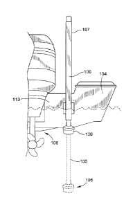
100161 FIG. 1 is a plan view of a boat with a transom-mounted sonar
transducer
assembly, according to an embodiment of the invention;
[0017] FIG. 2 is a pictorial illustration the sonar transducer assembly
attached to a
trolling motor, according to an embodiment of the invention;
100181 FIG. 3 is a pictorial illustration of the mounting and deployment of
the sonar
transducer assembly on a trolling motor, according to an embodiment of the
invention;
[0019] FIG. 4 is an exemplary screenshot of the display for the sonar
mapping system, in
accordance with an embodiment of the invention;
100201 FIG. 5 is an exemplary screenshot of the display for the sonar
mapping system, in
accordance with an embodiment of the invention;
[0021] FIG. 6 is an exemplary 3-D rendering of an underwater topographical
chart,
according to an embodiment of the invention; and
4
Date recue / Date received 2021-12-02
[0022] FIG. 7 is an exemplary screenshot of the display for the sonar
mapping system as
it would appear with a 360-degree sonar imaging system, in accordance with an
embodiment
of the invention.
[0023] The accompanying drawings include a number of exemplary charts as
they would
be displayed on the display of an embodiment of the sonar mapping system.
100241 While the invention will be described in connection with certain
preferred
embodiments, there is no intent to limit it to those embodiments. On the
contrary, the intent
is to cover all alternatives, modifications and equivalents as included within
the spirit and
scope of the invention as defined by the appended claims.
DETAILED DESCRIPTION OF THE INVENTION
[0025] FIGS. 1-3 show exemplary embodiment of a sonar transducer system
according to
embodiments of the invention. FIG. 2 shows a sonar mapping system 200
constructed in
accordance with an embodiment of the invention. The sonar mapping system 200
includes a
sonar imaging system 100 configured for mounting to various types of
watercraft.
[0026] The sonar mapping system 200 includes a sonar transducer assembly
106, a
control processor 110 and a sonar display. In the embodiment of FIG. 2, the
sonar mapping
system 200 is installed on a watercraft 104, illustrated as a motorized
fishing boat 104. An
optional second display 111 may be positioned at one of several different
locations on the
boat 104. FIG. 2 shows the second display 111 positioned towards the bow of
the boat 104.
In the embodiment of FIG. 2, the sonar imaging system 100, which includes the
sonar
transducer assembly 106, is deployed from the rear of the boat 104.
[0027] The control processor 110 is coupled to the sonar imaging system 100
and
receives sonar data from the sonar transducer assembly 106. The processor is
also coupled to
a display. In certain embodiments such as illustrated in FIGS. 1-3 and
described below, the
sonar imaging system 100 can interface with a single control processor 110, or
network with
multiple control processors 110. The one or more control processors 110 may be
integrated
into the sonar transducer assembly 106, or may be installed in a control head,
or command
Date recue / Date received 2021-12-02
console, such as shown on the boat 104 of FIG. 2. When integrated in the sonar
transducer
assembly 106, the modular transducer assembly 106 and control processor 110
may be
readily installed in a number of different types of watercraft 104. The sonar
imaging system
100 may connect, via wired or wireless connection, to the processor 110 and
display unit,
although in other embodiments, this communication may take place using other
wireless
technologies, including, but not limited to Wi-Fi, Bluetooth, for example.
[0028] In certain embodiments, the sonar imaging system 100 includes a
sonar transducer
assembly 106 and one of several possible deployment mechanisms. When the sonar
imaging
system 100 is connected to the control processor 110, a variety of menus and
views can be
added to the existing user interface and rendered on the display. While the
following will
describe various embodiments of such a user interface, the examples are to
demonstrate
functionality.
100291 FIG. 1 illustrates a sonar imaging system 100 deployed from the
transom 113 of
fishing boat 104, in accordance with an embodiment of the invention. In FIG.
1, the sonar
imaging system 100 is shown in its retracted state in which the sonar
transducer assembly
106 is close to the water line. However, phantom lines are used to show the
sonar imaging
system 100 in its deployed state, in which the sonar transducer assembly 106
is below the
keel 108 of the boat 104. In some embodiments, the depth at which the sonar
transducer
assembly 106 is deployed is adjustable and set by the user. In the embodiment
of FIG. 1, the
sonar transducer assembly 106 is attached at the end of a shaft 105 that
extends from, and
retracts into, a housing 107. The interior of shaft 105 provides a path for
cables from the
sonar transducer assembly 106 to a control processor 110 (shown in FIG. 2).
[0030] The sonar transducer assembly 106 can be deployed in any number of
ways,
including but not limited to, automatically based on speed, or and locally via
user controls on
the transducer deployment system. In some embodiments, when the sonar imaging
system
100 is in the process of deploying, a message will be displayed stating, for
example,
"Deploying transducer." When the sonar transducer assembly 106 reaches the set
depth or
the current limit, the deploying message will clear.
6
Date recue / Date received 2021-12-02
[0031] FIG. 3 shows an isolated view of the sonar imaging system 100
attached to the
trolling motor 112. The sonar transducer assembly 106 is attached to the end
of a shaft 114.
In certain embodiments, the shaft 114 for the sonar transducer assembly 106 is
coupled to a
non-rotating portion of shaft 116 for the trolling motor 112 by a quick
connecting clamp 115.
In particular embodiments, the position of the sonar transducer assembly 106
is fixed with
respect to the trolling motor 112. That is, the sonar transducer assembly 106
does not rotate
with the trolling motor shaft 116, instead remaining stationary with respect
to the boat. The
sonar transducer assembly 106 may be deployed, at the bow of the boat 104,
from the
transom, or through the hull of the boat 104.
100321 In one embodiment of the invention, the sonar imaging system 100 is
a sweeping,
or scanning, sonar system, also referred to as a 360-degree sonar imaging
system. The
sweeping/scanning sonar system may be configured to continually rotate the
sonar transducer
assembly 106 to provide a sonar image that includes a full 360-degree
underwater view.
Such 360-degree sonar imaging systems may be used to provide a picture-like
image of the
lake bed, river bed, or sea bed below and around the boat 104. The automatic
charting
function allows the user to create or update the image for a partial or entire
body of water,
and to store that image in memory for later recall. In other embodiments, the
sonar imaging
system 100 uses a sector-scanning device to image a predetermined portion of a
360-degree
area.
[0033] In alternate embodiments, the sonar imaging system 100 has a
stationary
transducer arranged to provide 2-D sonar imaging. Though not shown explicitly
in the
drawings, one of ordinary skill in the art will recognize that the sonar
imaging system 100
may be deployed through the hull of the watercraft 104 such that the sonar
imaging system
100 extends below the keel of the boat 104 during operation. In some
embodiments, this
sonar imaging system 100 is designed to extend down from the hull during
operation and to
retract up against, or into, the hull when not being used.
[0034] For example, in particular embodiments, the sonar mapping system 200
may be
configured such that the display with show retract and deploy messages. In
certain
7
Date recue / Date received 2021-12-02
embodiments, all retract and deploy messages are broadcast to any of the one
or more control
processor 110 that has the sonar transducer assembly 106 selected as one of
its sonar sources.
[0035] Referring again to FIG. 2, the aforementioned control processor 110
for the sonar
mapping system 200 is coupled to the sonar transducer assembly 106, and to the
display in
console 109 and to any additional displays, such as display 111. This coupling
could be
either wired or wireless depending on the sonar mapping system configuration.
The control
processor 110 is also coupled to, and able to access, electronic memory (not
shown), which is
configured to store charts or maps, along with sonar data from the sonar
transducer assembly
106. The memory may be located proximate the control processor 110 or the
display, in the
console 109 for example, or may be located remotely from the both the display
and the
control processor 110. It is envisioned that this memory, accessible to the
control processor,
includes both fixed and portable forms of memory. Such portable memory
includes, but is
not limited to, flash memory, solid-state memory, including, but not limited
to, thumb drives,
SD cards, and may also include optical storage media, etc.
[0036] FIGS. 4-5 show exemplary screen shots of the display showing a chart
300 with
topographical information provided by the sonar transducer assembly 106 (shown
in FIGS.
1-3), in accordance with an embodiment of the invention. These figures also
show elements
of an exemplary graphical user interface 302 for the sonar mapping system 200
(shown in
FIG. 2).
[0037] FIG. 4 shows an exemplary illustration of the chart 300 showing the
boat 104
location after the automatic mapping function has been initiated. In a
particular embodiment,
the sonar mapping system 200 is configured to access the chart 300 in memory
(not shown).
Thus, the user may access, in memory, a desired chart for a body of water 301,
for example
the body of water on which the user is navigating. When the automatic charting
function is
operating, the control processor 110 (shown in FIG 2) is configured to update
the chart 300
with topographical data 304 in real time based on sonar data provided by the
sonar transducer
assembly 106. The control processor 110 is also configured to render the
updated chart 300
on the display. The embodiments of FIGS. 4 and 5 show topographical data 304
as it might
appear if provided by the sonar imaging system 100 in FIG. 2, for example.
8
Date recue / Date received 2021-12-02
[0038] Additionally, the control processor 110 is configured to store these
newly created
or updated charts 300 in memory for later recall by the user. During each
successive use of
this chart 300, additional topographical data 304, for instance from an area
of the body of
water 301 not previously charted, can be added. Furthermore, the topographical
data 304
gathered during previous charting sessions can be updated to reflect any
changes in the
topography of the lake bed, river bed, or sea bed, as the case may be.
[0039] In certain embodiments, the chart 300 may include topographical data
304 of the
lakebed, seabed, or riverbed of the body of water 301 being navigated. In such
a case, the
automatic charting feature of the sonar mapping system 200 is configured to
update the
topographical data 304 in real time. However, it is envisioned that the
automatic charting
feature would be able to create from scratch a topographical map in real time
for the floor of
the body of water 301, for example using GPS coordinates, even when there is
no available
topographical data 304 in memory, or even if there is no chart 300 for the
body of water 301
in memory before the automatic charting feature is engaged. Topographical data
304 may be
displayed simultaneously, for example overlaid, with sonar imaging data.
[0040] The topographical data 304 may be in the form of a bathymetric chart
with
contour lines 306, as shown in FIGS. 4 and 5, where each contour line 306
indicates the
location of a particular water depth for the body of water 301. Alternatively,
the
topographical data 304 may be in the form of a bathymetric tints or shading to
indicate
various depths in the body of water 301, where the color of the tints change
as the underwater
topography progresses from shallow to deep. The display may be configured to
show the
bathymetric chart with tints and/or contour lines 306 in various colors which
are selectable
by the user on the graphical user interface 302. Similarly, it is envisioned
that the contour
lines 306 may be customized via the graphical user interface 302 such that the
contour lines
306 shown on the chart 300 indicate those depths selected by the user.
100411 In particular embodiments, the control processor 110 (shown in FIG
2) is also
configured to use GPS data to show, on the display, the position of the
watercraft 104, on the
chart 300 for the body of water 301 being navigated, in relation to
established landmarks or
in relation to the boundaries of the body of water 301.
9
Date recue / Date received 2021-12-02
[0042] As stated above, if the chart 300 for the body of water 301 being
navigated does
not include topographical data 304, the sonar mapping system 200 can
immediately create a
topographical chart of the lakebed, riverbed, or seabed being navigated. With
the automatic
charting feature engaged, the sonar data for a portion of the lakebed,
riverbed, or seabed is
converted into topographical data by the processor. With a sufficient number
of passes on
the body of water 301, the entire floor of the body of water 301 can be
charted. With each
pass, the control processor 110 (shown in FIG 2) performs a real-time update
of the chart for
the body of water 301 by adding contour lines 306, numerical displays, or
bathymetric
tints/shading to show water depths on the chart being displayed.
100431 FIG. 5 shows topographical data 304 in two different spots along the
path of
travel for the boat 104. This may happen when the automatic charting function
is paused for
one reason or another. However, if the space between the charted areas is not
too great, the
control processor 110 may perform an interpolation function to estimate the
missing
topography between the two charted areas. In this manner, the topographical
data 304 of
FIG. 5 may be rendered as a closed approximation of the actual topographical
data 304 as
shown in FIG. 4 for example.
100441 This same method may be employed to map the hardness, rather than
the
topography of the lakebed, riverbed, or seabed. Based on the strength of the
sonar signal
received by the sonar transducer assembly 106, the control processor 110 can
create a chart, a
color-coded chart for example, where the colors represent a spectrum of
hardness for the
lakebed, riverbed, or seabed surface. It is envisioned that, in certain
embodiments, the
graphical user interface 302 will allow the user to select the colors for this
function.
[0045] In many cases, the lakebed, riverbed, or seabed surface is covered
by varying
degrees of vegetation 316 (shown in FIG. 6). In particular embodiments, the
control
processor 110 is configured to process the signals from the sonar transducer
assembly 106
such that vegetation 316 on the lakebed, riverbed, or seabed surface can be
distinguished
from the lakebed, riverbed, or seabed surface itself, and distinguished from
fish or other
animals in the water. The control processor 110 is further configured to
display the
vegetation 316 on the chart 300. Furthermore, in particular embodiments, the
control
Date recue / Date received 2021-12-02
processor 110 is configured to show relative densities of vegetation 316 on
the lakebed,
riverbed, or seabed surface. The vegetation 316 may be shown in bathymetric
tints (in one or
more colors) so the color of the vegetation 316, as displayed for the user, is
distinct from the
color of the bottom surface for the body of water. The display may be a 2-D
display or a 3-D
rendering shown on the display screen of the user's electronic device. In
certain
embodiments, the user is able to choose the one or more colors of the
vegetation 316 as
shown on the user's display.
[0046] It is envisioned that the control processor 110 can be configured to
show both the
vegetation 316 on the lakebed, riverbed, or seabed surface while also
indicating the hardness
of that surface using various means, bathymetric tints being only one such
mean. Color
intensity or special symbols may also be used to distinguish between degrees
of surface
hardness. Similar means may also be used to distinguish between different
types of
vegetation.
100471 Further, embodiments of the invention are able to generate and
display a 3-D
topographical map 308 of a body of water in real time based on the sonar data
collected by
the sonar transducer. FIG. 6 shows an exemplary rendering of the 3-D
topographical map
308 along with the position of the boat. With the appropriate sonar transducer
assembly 106,
particular embodiments of the invention provide the user with the ability to
create or update
the 3-D topographical map 308 on the display and to save the created or
updated 3-D
topographical map 308 to memory. As in the previously-discussed embodiments,
the
graphical user interface 302 may be configured to allow the user to select the
colors for the 3-
D topographical map 308.
[0048] The control processor 110 (shown in FIG. 2) and the graphical user
interface 302
are configured such that the user of the sonar mapping system 200 (shown in
FIG. 2) can
adjust the display in a variety of ways including, but not limited to
transparency level, color,
sensitivity, contrast, etc. In a particular embodiment of the invention, the
user can select
from one of several drawing modes where the sonar data from the sonar
transducer assembly
106 overwrites the original chart data, overwrites previously-acquired sonar
data, or is
blended with original or previously-acquired sonar data. The control processor
110 may also
11
Date recue / Date received 2021-12-02
include a feature in which sonar data with greater intensity replaces sonar
data with lower
intensity.
[0049] FIG. 7 is an exemplary screen shot illustrating the look of the
display when the
automatic charting feature is used with the aforementioned 360-degree sonar
imaging system.
A chart 310 is created or updated to include 360-degree sonar imaging data
314, which
shows underwater images for a 360-degree area surrounding the boat 104 for the
body of
water 301. In the embodiment of FIG. 7, the 360-degree sonar imaging data 314,
which
resembles a series on non-concentric circles, may be in the form of a
bathymetric tints or
shading to help indicate various underwater features or objects imaged from
boat 104 in the
body of water 301. In some embodiments, the colors of the bathymetric tints
are selectable
by the user of the sonar mapping system 200 (shown in FIG. 2).
[0050] With the automatic charting feature engaged, the sonar data is
gathered for some
portion of the lakebed, riverbed, or seabed and converted into imaging data by
the control
processor 110. With a sufficient number of passes on the body of water 301,
the entire floor
of the body of water 301 can be imaged. With each pass, the control processor
110 (shown
in FIG. 2) performs a real-time update of the chart 310. The 360-degree sonar
imaging data
314 can be stored in memory for later recall by the user, and can also be
displayed
simultaneously, for example overlaid, with charts or topographical data
previously stored in
memory. A similar process could be employed to store sonar imaging data
captured using a
sector scanning device to capture a portion of a 360-degree area surrounding
the boat 104.
100511 The use of the terms "a" and "an" and "the" and similar referents in
the context of
describing the invention (especially in the context of the following claims)
is to be construed
to cover both the singular and the plural, unless otherwise indicated herein
or clearly
contradicted by context. The terms "comprising," "having," "including," and
"containing"
are to be construed as open-ended terms (i.e., meaning "including, but not
limited to,") unless
otherwise noted. Recitation of ranges of values herein are merely intended to
serve as a
shorthand method of referring individually to each separate value falling
within the range,
unless otherwise indicated herein. All methods described herein can be
performed in any
suitable order unless otherwise indicated herein or otherwise clearly
contradicted by context.
12
Date recue / Date received 2021-12-02
The use of any and all examples, or exemplary language (e.g., "such as")
provided herein, is
intended merely to better illuminate the invention and does not pose a
limitation on the scope
of the invention unless otherwise claimed. No language in the specification
should be
construed as indicating any non-claimed element as essential to the practice
of the invention.
100521
Preferred embodiments of this invention are described herein, including the
best
mode known to the inventors for carrying out the invention. Variations of
those preferred
embodiments may become apparent to those of ordinary skill in the art upon
reading the
foregoing description. The inventors expect skilled artisans to employ such
variations as
appropriate, and the inventors intend for the invention to be practiced
otherwise than as
specifically described herein. Accordingly, this invention includes all
modifications and
equivalents of the subject matter recited in the claims appended hereto as
permitted by
applicable law. Moreover, any combination of the above-described elements in
all possible
variations thereof is encompassed by the invention unless otherwise indicated
herein or
otherwise clearly contradicted by context.
13
Date recue / Date received 2021-12-02