Note: Descriptions are shown in the official language in which they were submitted.
INTEGRATED CIRCUIT IMAGING, RENDERING AND LAYOUT EDITING
SYSTEM AND METHOD
FIELD OF THE DISCLOSURE
100011 The present disclosure generally relates to integrated circuits,
and in
particular, to an integrated circuit imaging, rendering and layout editing
system and
method.
BACKGROUND
[0002] Integrated circuit (IC) design generally involves rendering a
particular IC
layout as a series of polygons outlining various IC features and
interconnections. Various
IC design tools are available to assist in defining these features and
functions and storing
them in a standardized format such as in a GDSII database file format, which
consists of
a binary file format representing planar geometric shapes, text labels, and
other
information about the layout in hierarchical form. The structured and 3D
layered layout
can then be used to map out and manufacture the IC.
[0003] To reverse engineer a particular IC layout, sequential images of the
IC are
taken and mosaicked, layer-by-layer, and processed to digitally reconstruct
the IC layout.
Automated IC feature extraction tools have been developed to automatically
identify IC
features and connections from these images and progressively reconstruct IC
layout
polygons, which may again be represented and stored in a standardized format
such as in
a GDSII database file format. However, as source IC imaging, mosaicking, and
layering
generally yields certain inaccuracies and imprecisions when automatically
processed for
feature extraction, manual and/or semi-automated post-processing is generally
required to
address misalignments, missed connections, artefacts and errors, for example,
which may
be expected when working from source images rather than a known layout design.
[0004] In current implementations, such manual or semi-automated processes
can be
executed by a team working in parallel on different regions of interest,
whereby corrected
polygons in any given region may predictably impact identified polygons in
other related
1017P-CIC-CAD I
CA 2985010 2017-11-08
regions and/or layers such that polygon corrections are generally propagated
on-the-fly
throughout the layout by reprocessing the entire layout polygon data. For
increasingly
large and complex polygon data structures representative of increasingly
complex and
dense IC designs, the on-the-fly propagation of polygon
corrections/adjustments,
particularly across a team working in parallel on a same reverse engineered
design layout,
can draw significant processing resources and lead to significant if not
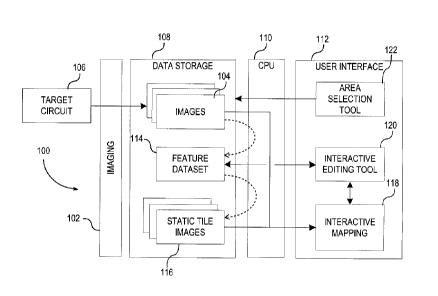
prohibitive lag
time between iterations.
[0005] This background information is provided to reveal information
believed by the
applicant to be of possible relevance. No admission is necessarily intended,
nor should be
construed, that any of the preceding information constitutes prior art or
forms part of the
general common knowledge in the relevant art.
SUMMARY
[0006] The following presents a simplified summary of the general
inventive
concept(s) described herein to provide a basic understanding of some aspects
of the
invention. This summary is not an extensive overview of the invention. It is
not intended
to restrict key or critical elements of the invention or to delineate the
scope of the
invention beyond that which is explicitly or implicitly described by the
following
description and claims.
[0007] A need exists for an integrated circuit imaging, rendering and
layout editing
system and method that overcome some of the drawbacks of known techniques, or
at
least, provides a useful alternative thereto. Some aspects of this disclosure
provide
examples of such systems and methods.
[0008] In accordance with one aspect, there is provided a computer-
implemented
method for verifying extracted integrated circuit (IC) features representative
of a source
IC and stored in a feature dataset structure, the method comprising:
converting, from the
feature dataset structure, a set of extracted IC features imaged within a
designated IC area
into a static tile image of the set representative of the area; rendering the
static tile image
for visualization as an interactive mapping of the feature dataset structure
within the area;
2
1017P-CIC-CADI
CA 2985010 2017-11-08
receiving input corrections for one or more of the set of extracted IC
features based on
the static tile image; and executing the input corrections on the feature
dataset structure to
produce an updated feature dataset structure.
[0009] In one embodiment, the method further comprises, prior to the
converting:
imaging the source IC to output a source IC image; automatically extracting a
plurality of
IC features from the source IC image; and storing respective representations
of each of
the extracted IC features in the feature dataset structure.
[0010] In one embodiment, the converting comprises converting respective
sets of the
extracted IC features imaged within juxtaposed areas into corresponding
juxtaposable
static tile images; and the rendering and the receiving are executed as a
function of the
corresponding static tile images.
100111 In one embodiment, adjacent ones of the juxtaposable static tile
images are
selectively mosaicked to render a combined interactive mapping.
[0012] In one embodiment, each of the corresponding static tile images is
stored at
multiple mapping resolutions such that, for a selected IC mapping area and
resolution,
corresponding ones of the juxtaposable static tile images are mosaicked to
render the
combined interactive mapping for the area at the mapping resolution.
[0013] In one embodiment, lower resolution tile images are constrained by
virtue of
their selected resolution to detail only larger scale IC features, whereas
higher resolution
tile images detail smaller scale IC features, and wherein the rendering
comprises
selectively rendering the interactive mapping at a selected resolution so to
selectively
constrain the rendering to the larger scale IC features.
[0014] In one embodiment, the method further comprises converting the
updated
feature dataset into an updated static tile image and rendering the updated
static tile
image for further visualization as an updated interactive mapping of the
updated feature
dataset.
3
1017P-CIC-CAD1
CA 2985010 2017-11-08
[0015] In one embodiment, the input corrections are interactively input
via the
interactive mapping.
[0016] In one embodiment, the extracted IC features are stored as
polygons in the
feature dataset structure, and wherein the static tile image is representative
of the
polygons in the area.
[0017] In one embodiment, the static tile image is colour coded as a
function of at
least one IC feature characteristic stored against the extracted IC features
in the feature
dataset structure.
[0018] In one embodiment, the at least one feature characteristic
comprises an
extracted feature layer identifier representative of a designated imaged IC
layer.
[0019] In one embodiment, the at least one feature characteristic
comprises a power
connection identified for at least some of the extracted IC features.
[0020] In one embodiment, the converting comprises generating a bitmap
image
representative of the extracted IC features in the area;
[0021] In one embodiment, the bitmap image is subsequently colour-coded as
a
function of at least one feature characteristic stored against the extracted
IC features in
the area.
[0022] In one embodiment, the rendering comprises at least partially
transparently
overlaying the static tile image onto a corresponding source IC image area
such that the
source IC image area is at least partially visible through the mapping.
[0023] In accordance with another aspect, there is provided an integrated
circuit (IC)
extraction verification system comprising: a user-interactive digital image
display; a data
processor; and a data storage accessible to the data processor, the data
storage having
stored therein: a feature dataset structure for storing extracted IC features
representative
of a source IC; and statements and instructions executable by the processor
to: convert,
from the feature dataset structure, a set of extracted IC features imaged
within a
designated IC area into a static tile image of the set representative of the
area; render, on
4
1017P-CIC-CAD1
CA 2985010 2017-11-08
the display, the static tile image for visualization as an interactive mapping
of the feature
dataset structure within the area; receive input corrections for one or more
of the set of
extracted IC features based on the static tile image; and execute the input
corrections on
the feature dataset structure to produce an updated feature dataset structure.
[0024] In one embodiment, the statements and instructions are further
executable to
convert respective sets of the extracted IC features imaged within juxtaposed
areas into
corresponding juxtaposable static tile images.
[0025] In one embodiment, adjacent ones of the juxtaposable static tile
images are
selectively mosaicked to render a combined interactive mapping.
[0026] In one embodiment, each of the corresponding static tile images is
stored at
multiple mapping resolutions such that, for a selected IC mapping area and
resolution,
corresponding ones of the juxtaposable static tile images are mosaicked to
render the
combined interactive mapping for the area at the mapping resolution.
[0027] In one embodiment, the lower resolution tile images are
constrained by virtue
of their selected resolution to detail only larger scale IC features, whereas
higher
resolution tile images detail smaller scale IC features, and wherein the
statements and
instructions are further executable to selectively render the interactive
mapping at a
selected resolution so to selectively constrain the rendering to the larger
scale IC features.
[0028] In one embodiment, the statements and instructions are further
executable to
convert the updated feature dataset into an updated static tile image and
render the
updated static tile image for further visualization as an updated interactive
mapping of the
updated feature dataset.
[0029] In one embodiment, the input corrections are interactively
captured via a user
interface to the interactive mapping.
[0030] In one embodiment, the extracted IC features are stored as polygons
in the
feature dataset structure, and wherein the static tile image is representative
of the
polygons in the area.
5
1017P-CIC-CAD1
CA 2985010 2017-11-08
[0031] In one embodiment, the static tile image is colour coded as a
function of at
least one IC feature characteristic stored against the extracted IC features
in the feature
dataset structure.
[0032] In one embodiment, the at least one feature characteristic
comprises an
extracted feature layer identifier representative of a designated imaged IC
layer.
[0033] In one embodiment, the at least one feature characteristic
comprises a power
connection identified for at least some of the extracted IC features.
[0034] In one embodiment, the static tile image is a bitmap image
representative of
the extracted IC features in the area;
[0035] In one embodiment, the statements and instructions are further
executable to
colour-code the bitmap image as a function of at least one feature
characteristic stored
against the extracted IC features in the area.
[0036] In one embodiment, the statements and instructions are further
executable to
at least partially transparently overlay the static tile image onto a
corresponding source IC
image area such that the source IC image area is at least partially visible
through the
mapping.
[0037] In accordance with another aspect, there is provided a non-
transitory
computer-readable medium having statements and instructions stored thereon for
execution by a processor to implement an integrated circuit (IC) feature
extraction
verification application by: converting, from a stored feature dataset
structure, a set of
extracted IC features imaged within a designated IC area into a static tile
image of the set
representative of the area; rendering, on an interactive digital display, the
static tile image
for visualization as an interactive mapping of the feature dataset structure
within the area;
receiving input corrections for one or more of the set of extracted IC
features based on
the static tile image; and executing the input corrections on the feature
dataset structure to
produce an updated feature dataset structure.
6
1017P-CIC-CAD I
CA 2985010 2017-11-08
[0038] In one embodiment, the converting comprises converting respective
sets of the
extracted IC features imaged within juxtaposed areas into corresponding
juxtaposable
static tile images; and the rendering and the receiving are executed as a
function of the
corresponding static tile images.
[0039] In one embodiment, adjacent ones of the juxtaposable static tile
images are
selectively mosaicked to render a combined interactive mapping; and each of
the
corresponding static tile images is stored at multiple mapping resolutions
such that, for a
selected IC mapping area and resolution, corresponding ones of the
juxtaposable static
tile images are mosaicked to render the combined interactive mapping for the
area at the
mapping resolution.
[0040] In one embodiment, lower resolution tile images are constrained by
virtue of
their selected resolution to detail only larger scale IC features, whereas
higher resolution
tile images detail smaller scale IC features, and wherein the rendering
comprises
selectively rendering the interactive mapping at a selected resolution so to
selectively
constrain the rendering to the larger scale IC features.
[0041] In one embodiment, the statements and instructions are further
executable to
convert the updated feature dataset into an updated static tile image and
rendering the
updated static tile image for further visualization as an updated interactive
mapping of the
updated feature dataset.
[0042] In one embodiment, the extracted IC features are stored as polygons
in the
feature dataset structure, and wherein the static tile image is representative
of the
polygons in the area.
[0043] In one embodiment, the rendering comprises at least partially
transparently
overlaying the static tile image onto a corresponding source IC image area
such that the
source IC image area is at least partially visible through the mapping.
[0044] In accordance with another aspect, there is provided a computer-
implemented
method for rendering an image defined by a vectorized feature dataset at
different
magnifications, the method comprising: converting, for each given image
rendering
7
1017P-CIC-CAD1
CA 2985010 2017-11-08
magnification, respective subsets of the vectorized feature dataset located
within
juxtaposed image areas into correspondingly juxtaposable static tile images of
the
respective subsets, wherein a resolution of each of the static tile images is
prescribed by
the given image rendering magnification; receiving selection of a selected
image
rendering magnification and selected image area; retrieving the static tile
images
corresponding to the selected image rendering magnification and selected image
area; and
rendering the retrieved static tile images for visualization of the selected
image area at the
selected image rendering magnification.
[0045] In one embodiment, lower magnification tile images are constrained
by virtue
of their associated magnification to detail only larger scale features,
whereas higher
magnification tile images detail smaller scale features, and wherein the
rendering
comprises selectively rendering the selected image area at a relatively higher
selected
magnification so to selectively constrain the rendering to the larger scale
features.
[0046] In one embodiment, the vectorized features are stored as polygons,
and
wherein the static tile images are representative of the polygons.
[0047] In one embodiment, the converting comprises generating a bitmap
image
representative of the vectorized features in the given area.
[0048] In one embodiment, the rendering comprises rendering the retrieved
static tile
images for visualization as an interactive mapping of the feature dataset
structure within
the area.
[0049] In one embodiment, the method further comprises: receiving input
corrections
for one or more given features based on the static tile images; and executing
the input
corrections on the feature dataset to produce an updated feature dataset.
[0050] Other aspects, features and/or advantages will become more
apparent upon
reading of the following non-restrictive description of specific embodiments
thereof,
given by way of example only with reference to the accompanying drawings.
8
1017P-CIC-CAD1
CA 2985010 2017-11-08
BRIEF DESCRIPTION OF THE FIGURES
[0051] Several embodiments of the present disclosure will be provided,
by way of
examples only, with reference to the appended drawings, wherein:
[0052] Figure 1 is a diagram of an integrated circuit (IC) imaging,
rendering and
layout editing system, in accordance with one embodiment;
[0053] Figures 2A is a simplified diagram of an automatically extracted
IC image
feature dataset represented by output polygons, in accordance with one
embodiment;
[0054] Figure 2B is a diagram of a static tile image representative of
the extracted
feature dataset depicted in Figure 2A and automatically converted therefrom
for
visualization as an interactive mapping thereof.
[0055] Figure 3 is an exemplary screenshot of an automatically extracted
IC circuit
layout image consisting of over 11500 polygons representing about 1.9MB of
stored data;
[0056] Figure 4 is another exemplary screenshot of an automatically
extracted IC
circuit layout image consisting of 255000 polygons representing about 49MB of
stored
data;
[0057] Figure 5A is another exemplary screenshot of an automatically
extracted IC
circuit layout image in which each imaged circuit line is represented by an
average of 60
polygon vertices due to inherent data extraction imperfections common in a
reverse
engineering environment and resulting in significantly increased IC layout
feature
rendering loads, whereas Figure 5B is a screenshot of the same IC circuit
layout image
once converted from extracted polygons into a bitmap image to reduce rendering
loads.
DETAILED DESCRIPTION
[0058] The systems and methods described herein provide, in accordance
with
different embodiments, different examples of an integrated circuit imaging,
rendering and
layout editing system and method that yield, for instance, improved IC reverse
engineering throughput, efficiency and reduced lag times. For example, in one
9
1017P-CIC-CADI
CA 2985010 2017-11-08
embodiment, errors, inaccuracies and/or misalignments identifiable in an
extracted IC
feature dataset can be more readily and efficiently addressed and propagated
throughout
the IC layout data structure without adversely affecting overall layout
processing
efficiency, throughput and correction lag times.
[0059] In one such example, feature extraction verifications in a given
area of interest
can be executed on an interactive extracted IC feature mapping of this area,
which may
be, for example, rendered to overlay a corresponding IC image of the IC area
of interest.
For example, an extracted feature dataset for a given area can first be
converted or
otherwise translated into a static tile image representative of the extracted
features in that
area, optionally with associated labeling and/or colour coding embedded
therein, thereby
reducing an overall screen rendering load on the system when seeking to
visualize
extracted features in that area. This static tile image can be dynamically
linked with the
extracted feature dataset so to be used as an interactive mapping of the
extracted features,
particularly when optionally rendered to overlay a corresponding source
imaging of the
IC in that area (i.e. the IC imaging used to source the feature extraction).
Accordingly, the
interactive mapping can be used to verify a feature extraction accuracy, and,
given its
dynamic interface to the underlying feature dataset, further used to guide
source
corrections thereto (e.g. identify misconnections, missed connections,
misalignments,
artefacts, staggered or otherwise noisy extracted polygon line outputs, etc.).
Such
corrections to the source dataset can then be propagated throughout the
extracted layout
architecture and used downstream to produce updated static tile images and
mappings of
the extracted IC layout dataset for further verification, revision and/or
editing as need be.
Using this approach, the user may act directly to correct or adjust a current
feature dataset
(e.g. to amend current feature dataset polygons, labels and related
annotations/metadata)
without unduly impacting a processing load on the system as a whole, for
example, which
may be concurrently used by a team working in parallel on different areas
and/or layers
of the extracted feature dataset. Namely, while multiple dataset corrections
may be
concurrently entered and tracked, these corrections are not immediately
conveyed as a
screen-rendered output, and in fact, may optionally be batch-compiled and
propagated
throughout the layout architecture on a scheduled basis so to minimize any lag
or
downtime during active verification.
1017P-CIC-CAD1
CA 2985010 2017-11-08
[0060] Given the nature and expected number of corrections required to
improve an
accuracy of automatically extracted features, for example, dynamic or on-the-
fly feature
correction rendering is not required for verifications to be pursued over a
given area, and
even less so in other connected or layered areas. Accordingly, extracted
feature
verifications and corrections can be reliably executed in parallel for various
areas of
interest on the basis of respective static tile images of the extracted
features in these
areas, each dynamically linked and mapped to the underlying feature dataset
sourced to
produce these images, thus reducing overall processing loads on the
verification system.
Batch and scheduled processing of input corrections can also alleviate
processing load
and reduce lag times without unduly impacting verification efficiency and
accuracy.
[0061] With reference to Figure 1, and in accordance with one
embodiment, an
exemplary integrated circuit (IC) extraction verification system 100 will now
be
described. In this embodiment, the system generally comprises or is configured
to
interface with or at least receive for further processing the output of an
imaging device
102, such as a scanning electron microscope (SEM), transmission electron
microscope
(TEM), focused ion beam (FIB) imaging device, atomic force microscope (AFM),
optical
imaging system such as an optical microscope, camera, flatbed scanner, x-ray
and the
like, that is used to generally produce a set of images 104 representative of
a source IC
106. These images 104 are generally, stored in digital form on a data storage
device 108
of the system 100 and optionally retrievable via CPU 110 and user interface
112 for
visualization. As will be appreciated by the skilled technician, other imaging
techniques
may also be considered, for example, in the implementation of the herein-
described
process in other fields, such as in medical imaging, geographic mapping,
geologic
mapping and the like.
[0062] In this particular embodiment, the stored images 104 are
automatically
processed to extract therefrom a set of IC features representative of the
source IC, in this
case stored as a feature dataset 114 stored in a conventional data structure
such as a
GDSII database file format, or again an SQL or other like database format, as
will be
readily known in the art. The dataset may otherwise or also be stored in
memory and/or
on a permanent storage device such as a hard or flash drive, and the like, as
will be
11
1017P-CIC-CAD1
CA 2985010 2017-11-08
readily appreciated by the skilled artisan. For instance, different imaging,
mapping and/or
data applications may invoke different source dataset types and storage
requirements
and/or preferences. Ultimately, the principles considered herein may be
applied to
different vectorized or like dataset types and/or storage options to improve
downstream
dataset rendering, editing and/or dynamic updating loads, for example.
[0063] With added reference to Figure 2A, the stored dataset may be
illustratively
stored as a set of polygons (e.g. see polygons 202 and 204) defined by
respective sets of
vertices 206 that may be interactively rendered for visualization, and
modification as
necessary. As will be described in greater detail below, where extracted
features may be
represented by a limited set of polygon vertices, these extracted polygons may
be
efficiently rendered without undue system processing loads. However, where
data
extraction artefacts and imperfections result in a significant increase in
automatically
generated polygon vertices, rendering loads may increase significantly if not
prohibitively. To mitigate burdensome processing loads, the feature dataset
is, in this
example, further processed to produce a set of static tile images 116 that may
be rendered
individually and/or mosaicked to depict a selectable area of the imaged IC
without need
to render each of its constituent polygon vertices. For example, the polygons
202 and 204
shown in Figure 2A can be converted, as described herein, into the static tile
image 208
of Figure 2B, the latter generally corresponding to a much lower rendering
load than the
former, particularly as the number of polygons and vertices increase, as will
be described
and exemplified further below. Furthermore, while the rendering load
associated with a
given area will vary when rendering polygons based on the number of polygons
involved,
the size of the static tile images will remain predictably the same based on
the predefined
static tile image pixel size.
[0064] In this particular embodiment, the converted static tiles 116 are
rendered as an
interactive mapping 118 alongside an interactive feature dataset editing tool
120 such that
appropriate corrections may be efficiently applied to the extracted dataset
through
visualization of the rendered static tile images without necessarily rendering
any of the
extracted polygons or vertices themselves. For example, the user interface 112
may allow
the user to select an IC area for visualization and verification via area
selection tool 122,
12
1017P-CIC-CAD1
CA 2985010 2017-11-08
which will invoke the system to retrieve, in this example via CPU 110 and data
storage
108, one or more corresponding IC images 104 from the data store, as well as
the feature
dataset 114 and static tile image(s) 116 corresponding thereto.
[0065] To mitigate excessive image rendering loads, the CPU 110 will
generate a
corresponding interactive mapping 118 consisting of the retrieved static tiles
116, in this
example overlaid onto the source IC images 104 to identify possible
discrepancies
generated during the automated feature extraction process (e.g. feature
misalignments;
inaccurate feature connections, disconnections and/or misconnections,
omissions,
artefacts and the like), that are dynamically mapped to the stored feature
dataset 114 via
interactive editing tool 120. For instance, the user interface may allow the
user to
navigate the interactive mapping 118 using an interactive cursor, pointer or
the like
operated against the static tile(s) 116 while tracking a relative position
(e.g. static image
coordinates) thereof against corresponding polygon vertex coordinates. In
doing so, a
user may interactively select a particular feature dataset polygon and/or
vertex on the
static tile image(s) 116 without necessarily having to render this polygon,
but rather by
dynamically mapping user actions on the static tile(s) 116 against an editable
listing of
such polygon vertices provided via the editing tool 120.
[0066] Since the user is not directly interfacing with live rendering of
the stored
feature dataset, dataset corrections may be applied directly (e.g.
polygon/vertex
corrections) without having to immediately render and propagate such
corrections
throughout the system interface. At any time, however, all or a relevant
subset of the
static tile images 116 may be regenerated based on one or more input
corrections to the
feature dataset 114 for visualization, but again, at a much reduced rendering
load.
Furthermore, as different users may be working on different areas of the
feature dataset,
different static tile images may be rendered to reflect input corrections at
different times
without impacting the work of others, even when effectively operating on the
same or
related features that may span multiple tile images.
[0067] In some embodiments, different sets of extracted IC features
imaged within
juxtaposed areas may be correspondingly converted to juxtaposable static tile
images that
13
1017P-CIC-CAD I
CA 2985010 2017-11-08
may thus be mosaicked, as need be, to produce a larger combined area view and
dynamic
mapping.
[0068] Given that verification work done at different image resolutions
may generally
involve corrections applied to correspondingly sized features, static tile
images may be
produced at different scales such that smaller features generally unworkable
at lower
resolutions are not necessarily included in larger, high level tiles, but
increasingly
included as higher resolution tiles are requested when working on the finer
features of the
extracted layout. In comparison, when rendering the entire featured dataset
for a given
area selection irrespective of resolution, it will be appreciated that a
significant and often
prohibitive increase in rendering load will ensue for large-scale
manipulations. Using the
approach described herein, scaling factors maybe appropriately invoked to only
render
features reasonably workable at any given scale and thus minimize the
inclusion of fine
details for regions exhibiting high feature densities at a given resolution.
Accordingly,
corresponding static tile images may be stored at multiple mapping resolutions
such that,
for a selected IC mapping area and resolution, corresponding juxtaposable
static tile
images can be mosaicked to render an appropriate combined interactive mapping
for this
area at the selected mapping resolution. As noted above, lower resolution tile
images will
be constrained by virtue of their selected resolution to detail only larger
scale IC features,
whereas higher resolution tile images will detail smaller scale IC features.
[0069] As will be appreciated by the skilled artisan, while the above
contemplates the
automated extraction of IC feature dataset polygons, and the conversion
thereof to
representative static bitmap tile images, other file and image formats may
also be
considered without departing from the general scope and nature of the present
disclosure.
For example, and as noted below, while the use of a static bitmap (.bmp) image
tile
format allows for a direct mapping of image bits to pixels, other static image
tile file
formats may also be considered, such as .tif, jpg, jp2 and the like, without
departing
from the general scope and nature of the present disclosure, some of which in
fact
allowing for even further overall processing/rendering load reductions through
well
known image compression techniques that, in most cases, would not perceptibly
impact
processing/rendering loads.
14
1017P-CIC-CADI
CA 2985010 2017-11-08
[0070] Furthermore, while the examples provided herein focus on the
provision of an
IC feature dataset rendering and editing tool, the image rendering
optimization technique
considered herein may also be applicable to other applications in which large
(vectorized)
datasets must be processed for efficient rendering and user interaction,
particularly where
such datasets are selectively rendered at different resolutions/magnifications
in which, for
example, high detail levels may be lost or imperceptible and thus
unnecessarily rendered
for lower magnifications. For example, scalable geographic and/or geological
mapping
applications may rely on high volume vectorized datasets that, at lower
magnifications,
need not encompass the full set of vectors to provide the desired
visualization. These
datasets may also be automatically acquired and/or compiled from various
geolocational
imaging techniques that, as in the above IC example, introduce certain
imperfections,
inaccuracies and/or artefacts that may undesirably increase mapping/rendering
loads and
that could thus further benefit from the static tile image conversion
techniques considered
herein. Further, by implementing the approaches considered herein, a (dynamic)
mapping
may be produced for the entire dataset in a given area without necessarily
invoking
prohibitive image-rendering loads for low magnifications.
[0071] Likewise, certain gaming applications, particularly 3D gaming
applications
that store large datasets for a given area to be selectively viewed "up close"
may not
require the same level of rendering precision when viewed "from afar". By
systematically
converting vertorized datasets for each area into respective magnification-
appropriate
static tile images, to be optionally used as dynamic mappings of this dataset,
a rendering
load may be drastically reduced thus improving overall image and game
processing
efficiencies.
[0072] Similarly, various medical data and/or imaging applications may
rely on large
vectorized dataset, their rendering efficiency of which may be drastically
improved by
implementing a computerized method as described herein. Other applications may
also be
considered to provide a like effect, as will be appreciated by the skilled
artisan.
[0073] In some embodiments, the static tile images may be colour-coded
based on
one or more operational parameters or characteristics associated with selected
dataset
1017P-CIC-CAD1
CA 2985010 2017-11-08
features. For example, returning to the IC layout example, extracted features
associated
with a particular IC layer may all share a same layer identifier and thus,
invoke a same
static tile image colouring allowing static tile images representative of
different IC layout
layers to show extracted features in respective layer-specific colours. In the
context of
bitmap tiles, each tile may still represent tile pixels in a binary format to
locate the
position of extracted features, and invoke appropriate layer-specific
colouring upon
rendering by applying a uniform colour code to the bitmap image based on an
associate
layer identifier. Multicolour bitmaps may also be considered, for example,
when
associating distinguishing parameters to selected features, such as those
characterized by
a power connection, or the like, so that they may be distinguishably rendered
during
verification.
[0074] With reference now to Figures 3 to 5B, an exemplary impact of the
processes
described herein will now be illustrated with reference to various sample IC
layout
images. In the below examples, a 1920x1080 screen resolution is assumed in
providing
sample calculations.
[0075] The extracted IC layout image shown in Figure 3 represents an area
of about
17500 pixels by 8200 pixels and contains over 11500 polygons that add up to
about
1.9MB of stored data. Using a standard polygon rendering process, 1.9MB of
data would
thus have to be rendered to output this image using the stored polygons.
[0076] In comparison, the bitmap conversion and rendering processes
described
herein can allow for a significant reduction in data rendering load. For
example, a set of
1024pixel x 1024pixel bitmap tiles can be generated from the extracted
polygons, each
tile representing 1 bit per image pixel thus each invariably representing
128KB in size on
disk. At any given time, the user could render a maximum of 9 tiles (9 x 128KB
=
1152KB) which generally represents much less data than if the full size
underlying
polygons were used. In this example, a bitmap (.bmp) file format is
considered, which
does not involve any data compression. A tagged image file format (.tff) could
also be
considered to provide a similar advantage. On the other hand, the use of a
compressed
image file format such as jpeg (.jpg) could further improve performance,
particularly
16
1017P-CIC-CAD1
CA 2985010 2017-11-08
when dealing with relatively small image files such as considered herein in
which
compression and decompression cycles do not add much load to the system.
Accordingly,
the herein-reported rendering load improvements figures may be further
improved upon
by considering one or more compressed image file formats, for example.
[0077] Using this approach, rendering the image view shown in Figure 3
using
bitmap tiles could be accomplished using between 0.125MB and 1.125MB depending
on
how the bitmap tiles are positioned in respect to this view. Accordingly, the
use of bitmap
tiles results in a rendering load of between 6.6% and 59% as compared to that
required
for full polygon rendering.
[0078] As will be appreciated by the skilled artisan, the rendering load
savings will
vary as the user zooms in and out, and in some embodiments, the system may be
adapted
to selectively render converted bitmap tiles or full polygons depending the
selected
viewing resolution (e.g. full polygons could be rendered when users select
certain
viewing magnifications beyond a preset magnification threshold.
[0079] The extracted IC layout image shown in Figure 4 represents an area
of about
111400pixels by 52000pixels and contains over 255000 polygons that add up to
about
49MB. To render this view using polygons, one would need to load that much
data and at
this zoom level, many of the rendered polygons are not even visible. In
comparison, to
render the same view using bitmaps, one would need at most 1152KB (1.125MB) as
stated above, which is about 2.3% of the 49MB required if using polygons,
which ratio
gets smaller and smaller as the rendered view is zoomed out further and
further to
encompass visualization of even greater numbers of extracted polygons.
[0080] As noted above, the significant and increasing amount of data
required to
render a given view using polygons as one zooms out can be explained by two
main
factors. First, rendering using polygons requires loading every single polygon
present in
the view irrespective of viewing magnification, which means that for lower
magnifications, a significant number of polygons may be rendered without
necessarily
being visually distinguishable by the user.
17
1017P-CIC-CAD1
CA 2985010 2017-11-08
[0081] Secondly, imperfections generated during the data extraction
process (chip
delayering, imaging, polygon generation, etc.) can cause the generation of
significantly
more polygon vertices than would otherwise be required to render the same
extracted
image under ideal conditions, which are not generally available in a reverse
engineering
context. These somewhat superfluous polygon vertices thus result in larger
polygon
storage sizes and rendering loads. Namely, the size on disk of any given
polygon
increases with the number of its constituent vertices, each vertex being made
of two
integers that represent its coordinates with each integer being represented by
32bits.
[0082] In comparison, and in accordance with one embodiment, bitmap
images can
be computed for different preset resolutions such that the rendering system
can use at
most 1 bit per screen pixel when rendering a given view no matter the zoom
level.
Accordingly, the amount of data required to render any given view using bitmap
images
will not depend on the zoom level, and only those features perceptively
distinguishable
on screen will be displayed to the user (as opposed to rendering visually
undistinguishable and thus perceptively overlapping polygons).
[0083] The extracted IC layout image shown in Figure 5A illustrates the
impact data
extraction imperfections can have on rendering load. If the data extraction
were flawless,
the image shown in Figure 5A would show perfectly straight lines, each one
ideally
defined by 5 polygon vertices. In comparison, actual reverse engineer imaging
data
extractions resulted in the production of the jagged lines shown here, each
one, on
average, defined by 60 polygon vertices, a twelve-fold increase from ideal
imaging.
[0084] In Figure 5B, the same extracted image is rendered using a bitmap
conversion
process, as described above, to produce a visually indistinguishable version
of the same
image, but without the added rendering load imparted by the extracted
imperfections (i.e.
the bitmap images are impartial to imperfections, allocating a single bit per
viewing pixel
whether this pixel is imaged as being within or outside a particular image
feature).
[0085] While the present disclosure describes various exemplary
embodiments, the
disclosure is not so limited. To the contrary, the disclosure is intended to
cover various
18
1017P-CIC-CADI
CA 2985010 2017-11-08
modifications and equivalent arrangements included within the general scope of
the
present disclosure.
19
1017P-CIC-CADI
CA 2985010 2017-11-08