Note: Descriptions are shown in the official language in which they were submitted.
IN THE UNITED STATES PATENT AND TRADEMARK OFFICE
Patent Application Under 37 C.F.R. 1.53(b)
for
METHOD AND SYSTEM FOR DETERMINING A STATUS OF ONE OR
MORE TANKS IN A PARTICULAR LOCATION
CROSS-REFERENCE TO RELATED APPLICATIONS
The present application claims priority to U.S. Patent Application Serial No.
62/163,789 filed on May 19, 2015.
BACKGROUND OF THE INVENTION
The present invention relates to determining a status of one or more tanks in
a
particular location and/or an amount of crude oil or other commodity that is
stored in one
or more tanks in a particular location, such as a tank farm or storage hub.
Liquid energy commodities, such as crude oil, comprise a multi-billion dollar
economic market. These commodities are bought and sold by many parties, and as
with
any traded market, information about the traded commodities is very valuable
to market
participants. Specifically,
CA 2985814 2019-03-08
the operations of the various components and facilities of the production,
transportation,
storage, and distribution systems for each of these commodities can have
significant impacts
on the price and availability of these commodities, making information about
said operations
valuable. Furthermore, such information generally is not disclosed publicly by
the various
component and facility owners or operators, and access to said information is
therefore
limited.
For example, crude oil is typically stored in large, above-ground tanks. A
collection
of such above-ground tanks at a particular location is often referred to as a
"tank farm." To
the extent that a collection of such above-ground tanks is located near the
intersection of
many outgoing and/or incoming pipelines or transportation (tanker ship, truck,
rail, etc.)
receipt and delivery points (or nodes), it may also be referred to as a
"storage hub." Similarly,
other liquid energy commodities of interest, including natural gas liquid
derivatives (or
condensates) and refined petroleum products (such as diesel, gasoline, fuels
oils, and
biofuels), may also be stored in such above-ground tanks on a tank farm or at
a storage hub.
In any event, whether crude oil, other liquid energy commodity, or other
commodity
activity at tank farms or storage hubs is of interest to market participants,
along with
regulatory agencies and owner-operators.
U.S. Patent No. 8,842,874 describes certain methods and systems for
determining an
amount of crude oil or similar liquid energy commodity that is stored in a
particular location,
such as a tank farm or storage hub.
As described in U.S. Patent No. 8,842,874, each tank in a particular location
is
researched using available resources or visual inspection, and all relevant
information about
each tank, including volume capacity information, tank type (i.e., floating
roof or fixed roof),
roof type, physical dimensions, emissions data and/or any other information
contained in
tank construction
2
CA 2985814 2019-03-08
CA 02985814 2017-11-10
WO 2016/187376 PCT/US2016/033184
permits, safety permits, and/or other accessible sources, is stored in a
database at a central
processing facility.
On a predetermined schedule or in substantially real-time, an inspection of
each tank at
the particular location is conducted. Such an inspection includes the
collection of one or more
photographic images (i.e., visible spectrum) or video of each tank, the
collection of infrared
images or video of each tank, and/or the collection of other types of images
of each tank. The
collected images of each tank are then transmitted to a central processing
facility and stored in a
database
At the central processing facility, an analysis of the collected images is
conducted, which
allows for a calculation of the amount of crude oil in each tank.
With respect to the analysis of a tank with an external floating roof (EFR),
one preferred
form of analysis is to determine the height of the roof relative to the top of
the selected tank
using standard image pixel number determination techniques. Based on the
determined height of
the roof (which is indicative of the liquid level) and the volume capacity
information and/or the
physical dimensions of the selected tank stored in the database at the central
processing facility,
the amount of crude oil in the tank can be calculated.
With respect to the analysis of a tank with an external floating roof (EFR),
another
preferred form of analysis is an image processing analysis to model the top,
roof, and base of a
tank as parallel elliptical planes and to determine the roof height by
calculating the separation
distance between these elliptical planes. Based on the determined height of
the roof relative to
the base and/or the top of the tank (which again is indicative of the liquid
level) and the volume
capacity information and/or the physical dimensions of the selected tank
stored in the database at
the central processing facility, the amount of crude oil in the tank again can
be calculated.
3
CA 02985814 2017-11-10
WO 2016/187376 PCT/US2016/033184
Various other methods or techniques can also be employed to complement or
provide
additional measurements for determining the height of the tank roof.
For example, the roof of an EFR tank is supported from the center of the roof
by an
extended arm that is generally connected to a ladder, which, in turn, is
supported on the outside
of the tank wall. The ladder allows access to the roof of the tank for
inspection and maintenance
purposes. To determine or confirm the height of the tank roof, the angle of
inclination of the arm
can be measured relative to a defined reference on the tank.
For another example, in determining the height of the roof of an EFR tank,
shadows of a
tank can be analyzed. Specifically, under certain natural sunlit conditions,
shadows from the
.. tank walls may be visible on the tank roof and on the ground. The area or
other measure of the
size of the crescent-shaped shadows which are cast from the tank wall onto the
tank roof and/or
the ground vary with the roof height. For tanks of equal size and illumination
angle with respect
to the sun's position, the area of the crescent-shaped shadow is smaller in
the tank with the
higher liquid level and larger in the tank with the lower liquid level. The
ratio of the areas of the
internally cast crescent-shaped shadow to the externally cast crescent-shaped
shadow can be used
to determine relative roof height of the two tanks
With respect to tanks with fixed roofs (1FR), the liquid level within a
selected tank can be
ascertained from collected infrared images, as the temperature of the stored
oil is different than
that of the air above it in the tank. One preferred form of analysis to
determine the height of the
liquid level in the tank is to measure the pixel distance from the liquid-gas
boundary to the base
of the tank. Based on the ascertained liquid level within the tank and the
volume capacity
information and/or the physical dimensions of the selected tank stored in the
database at the
central processing facility, the amount of crude oil in the tank can again be
calculated.
4
CA 02985814 2017-11-10
WO 2016/187376 PCT/US2016/033184
As described in U.S. Patent No. 8,842,874, once the analysis of each tank in a
particular
location is completed, the calculated amounts can then be communicated to
market participants
and other interested parties, e.g., third parties who would not ordinarily
have ready access to
such information about the amount of crude oil in storage at a given time. By
summing the
volumes in all of the tanks or in a grouping of selected tanks, information
about the total amount
of crude oil at the particular location or in the grouping of selected tanks
(for example, tanks
owned by a particular company or the amounts of crude oil of a certain type)
can also be
calculated and communicated to market participants and other interested
parties. It is
contemplated and preferred that such communication to third-party market
participants could be
achieved through electronic mail delivery and/or through export of the data to
an access-
controlled Internet web site, which market participants can access through a
common Internet
browser program.
As described in U.S. Patent No. 8,842,874, a system for determining an amount
of a liquid
energy commodity stored in a tank in accordance with the present invention
includes: (a) a tank
.. information receiving module for receiving and processing tank information,
including volume
capacity information, storing such information in a database; (b) an image
receiving module for
receiving and processing images of one or more tanks, storing such images in a
database; (c) an
analysis module for querying the databases and analyzing the images of each
tank to determine a
liquid level for each tank; (d) a calculation module for calculating the
amount of the liquid
.. energy commodity in each tank based on the determined liquid level and the
volume capacity
information from the database; and (e) a communications module for
communicating
information about the liquid energy commodity to a third-party market
participant.
With respect to the acquisition and collection of images and/or other data
about each tank,
5
CA 02985814 2017-11-10
=
WO 2016/187376 PCT/1JS2016/033184
imaging and sensing technology is now available that will generate a point
cloud of three-
dimensional coordinates (i.e., a 3D point cloud) from acquired imagery, where
each data point is
registered to a geospatial coordinate system, so that its location in space is
also known and
stored. For example, WaldoAir Corp. of Franklin, Tennessee manufactures and
distributes its
XCAM-B camera, which can be used to collect data and generate such a 3D point
cloud. It
should be noted that data which includes two dimensions plus height, often
referred to as 2.5D, is
included in the term "3D point cloud" as that term is used in the present
application, as three
dimensions are at least partially represented. Furthermore, as the term is
used in the present
application, a "3D point cloud" also includes a point cloud with more than
three dimensions,
with, for example, the addition of a time dimension.
The raw image data from the XCAM-B camera or another sensor is processed using
certain
software to generate the 3D point cloud; for example, one such commercially
available software
product is licensed by Pix4D SA of Lausanne, Switzerland. Regardless of which
camera or
sensor or processing software is used, the resultant data is three-
dimensional, where each data
coordinate in the three-dimensional data set (or 3D point cloud) represents
geospatial and/or
other information pertaining to a point in three-dimensional space. Depending
on the data
acquisition technology deployed, each data coordinate in the three-dimensional
data set (or 3D
point cloud) may represent a geospatial location in addition to some physical
parameter, which
may include, but is not limited to, a color intensity, a thermal emissivity
value, a relative
reflectivity value, etc. The three-dimensional data set (or 3D point cloud)
can represent the data
as collected in raw form by the imaging or sensing system or a data set where
some standard
pixel interpolations, value averaging, or other default system noise reduction
processing have
been applied to the data.
6
P. CA 02985814 2017-11-10
WO 2016/187376 PCT/US2016/033184
Thus, it would be desirable to acquire a three-dimensional data set (or 3D
point cloud) to
represent storage tanks with external floating roofs (EFR) or fixed roof tanks
(IFR), and then use
that three-dimensional data set to determine a status of one or more tanks in
a particular location
and/or an amount of crude oil or similar commodity that is stored in one or
more tanks in a
.. particular location.
SUMMARY OF THE INVENTION
The present invention is a method and system for determining a status of one
or more
tanks in a particular location and/or an amount of crude oil or other
commodity that is stored in
one or more tanks in a particular location, such as a tank farm or storage
hub, a method and
system that makes use of a three-dimensional data set (or 3D point -cloud)
that is representative
of storage tanks with external floating roofs (EFR) or fixed roof tanks (IFR).
In accordance with the method and system of the present invention, each tank
in a
particular location is researched using publicly available resources,
regulatory resources, owner-
operator resources, visual inspection, or otherwise, and all relevant
information about each tank,
including volume capacity information, tank type (i.e., floating roof or fixed
roof), roof type,
physical characteristics and dimensions, emissions data, and/or any other
information contained
in tank construction permits, safety permits, or other accessible sources, is
stored in a database,
which may be hosted at a central processing facility.
A single tank or cluster of tanks may also be associated with connected
pipelines and/or
other receipt and delivery points (or nodes) in a broader supply chain
network, such as delivery
berths at a port where the tank resides or a truck or rail line connected to a
tank farm of interest.
Information about interconnections between components may also be stored in
the database.
7
CA 02985814 2017-11-10
WO 2016/187376 PCT/US2016/033184
At some point in time, an inspection of each tank at the particular location
is conducted.
For example, such an inspection may be an aerial inspection, in which
helicopters, airplanes,
unmanned aerial vehicles (UAV) or drones, or remote-controlled aircraft fly
over the location.
For another example, the inspection may be conducted by space-based satellites
or drones during
a pass-over of the location of interest. Irrespective of how the inspection is
conducted, such an
inspection includes the collection of data for each tank (or collection of
tanks). Specifically, the
sensor (or sensors), in combination with certain processing software, is used
to acquire and
generate a three-dimensional data set (i.e., a 3D point cloud), where each
data point is
representative of a point on a surface of interest and is (or can be)
registered to a geospatial
.. coordinate system.
The acquired three-dimensional data set (i.e., a 3D point cloud) is
transmitted to a central
processing facility and stored in a database. Alternatively, the acquired
three-dimensional data
set could be stored locally, for example, in a memory component associated
with the sensor
acquiring the three-dimensional data, for subsequent analysis.
An analysis of the three-dimensional data set is conducted, which allows for a
calculation
of the amount (or volume) of crude oil or other commodity in each tank and/or
other
determinations of status of each tank.
With respect to the "status" of each tank, this term can refer to, for
example: operational
status, such as full, empty, in maintenance, under construction, or under
demolition. This term
can also refer to economic status, such as: (i) speculative status, i.e.,
commodity is being stored
to benefit from future higher prices; (ii) transactional status, i.e., the
commodity stored serves a
constant demand sink; or (iii) leased space status (i.e., the tank is being
leased). This term can
also refer to network status, such as: (i) buffer, i.e., the commodity stored
is used as a buffer
8
1.$ CA 02985814 2017-11-10
WO 2016/187376 PCT/US2016/033184
between two nodes in a network; (ii) valve, i.e., the stored commodity is
present to manage
pipeline pressures; or (iii) mixing/blending area, i.e., the presence of two
commodity types (or
one or more types of one commodity) reflects that the tank serves as a
mixing/blending area.
After the analysis of the three-dimensional data set is completed, it is then
possible to
calculate liquid content (inventory level) and/or other volumes associated
with the three-
dimensional tank structure.
In addition to calculating liquid content, three-dimensional volumes for other
tank
components (roof, walls, wall rims, wall protrusions, roof armature, ladders,
roof vents, roof
protrusions, and so on) can be used to determine other physical states of a
tank life cycle,
including, but not limited to, construction, hydrotesting, maintenance,
venting, deconstruction,
non-operation, safety testing, content quality testing, and so on.
Once the analysis of each tank in a particular location is completed, the
calculated
amounts or other status can then be communicated to market participants and
other interested
parties, e.g., third parties who would not ordinarily have ready access to
such information about
the amount of crude oil or other commodity in storage or status of the tanks
at a given time. By
summing the volumes in all of the tanks or in a grouping of selected tanks,
information about the
total amount of crude oil or other commodity at the particular location or in
the grouping of
selected tanks (for example, tanks owned by a particular company or the
amounts of crude oil of
a certain type) can also be calculated and communicated to market participants
and other
interested parties. It is contemplated and preferred that such communication
to market
participants could be achieved through electronic mail delivery and/or through
export of the data
to an access-controlled Internet web site, which market participants can
access through a
common Internet browser program. Of course, communication of information and
data to
9
CA 02985814 2017-11-10
WO 2016/187376 PCT/US2016/033184
market participants may also be accomplished through a wide variety of other
known
communications means without departing from the spirit and scope of the
present invention.
Furthermore, in addition to reporting the calculated amounts or other status
of one or
more tanks, other information can also be reported to market participants,
including, for
example, aggregated tank information, information about patterns of change,
alerts on changes in
operations of the tanks, alerts on correlated market conditions, and alerts on
changes to
associated infrastructure connected to a particular tank farm or storage hub.
The central processing facility hosts a digital computer program (i.e.,
computer-readable
instructions executed by a processor of a computer) that includes appropriate
modules for
executing the requisite instructions (which are stored in a memory component)
for performing
the operational steps of the method described above. Alternatively, the
digital computer program
could be hosted locally in a memory component associated with the sensor
acquiring the three-
dimensional data. In either case, an exemplary system for determining an
amount of a
commodity stored in one or more tanks in accordance with the present invention
includes: (a) a
tank information receiving module for receiving and processing tank
information, including
volume capacity information, storing such information in a database; (b) a
data receiving module
for receiving three-dimensional data sets representative of the one or more
tanks, storing such
data sets in a database; (c) an analysis module for querying the databases and
analyzing the
three-dimensional data sets to determine a liquid level for each tank and/or
status of each tank;
.. (d) a calculation module for calculating the amount of the commodity in
each tank based on the
determined liquid level and the volume capacity information from the database
and/or for
making other determinations of status; and (e) a communications module for
communicating
information about the commodity to a market participant.
In one of its aspects, the present invention resides in a method for
determining a
status of one or more tanks in a particular location, comprising the steps of:
storing
information associated with each of the one or more tanks at the particular
location in a
database; periodically conducting an inspection of each of the one or more
tanks at the
particular location from a remote vantage point without direct access to each
of the one or
more tanks, including using a sensor to acquire a three-dimensional data set
representative
of the one or more tanks, including a roof of each of the one or more tanks;
analyzing the
three-dimensional data set, using a processor of a computer, to determine a
status of each
of the one or more tanks; and communicating information about the status of
each of the
one or more tanks at the particular location to a market participant.
In a further aspect, the present invention resides in a method for determining
an
amount of a commodity stored in one or more tanks in a particular location,
comprising
the steps of: storing information associated with each of the one or more
tanks at the
particular location in a database, including volume capacity information;
periodically
conducting an inspection of each of the one or more tanks at the particular
location from a
remote vantage point without direct access to each of the one or more tanks,
including
using a sensor acquiring a three-dimensional data set representative of the
one or more
tanks, including a roof of each of the one or more tanks; analyzing the three-
dimensional
data set, using a processor of a computer, to determine a liquid level for
each of the one or
more tanks; calculating the amount of the commodity in each of the one or more
tanks,
using the processor of the computer, based on the determined liquid level and
the volume
capacity information retrieved from the database; and communicating
information about
the amount of the commodity at the particular location to a market
participant.
In a still further aspect, the present invention resides in a method for
determining a
status of one or more tanks in a particular location, comprising the steps of:
receiving
information associated with each of the one or more tanks and storing the
information in a
database; receiving a three-dimensional data set representative of the one or
more tanks,
including a roof of each of the one or more tanks; analyzing the three-
dimensional data
set, using a processor of a computer, to determine a status of each of the one
or more
tanks; and communicating information about the status of each of the one or
more tanks at
the particular location to a market participant.
10a
CA 2985814 2018-01-24
In a still further aspect, the present invention resides in a method for
determining
an amount of a commodity stored in one or more tanks in a particular location,
comprising
the steps of: receiving volume capacity information associated with each of
the one or
more tanks, and storing the volume capacity information in a database;
receiving a three-
dimensional data set representative of the one or more tanks, including a roof
of each of
the one or more tanks; analyzing the three-dimensional data set, using a
processor of a
computer, to determine a liquid level for each of the one or more tanks;
calculating the
amount of the commodity in each of the one or more tanks, using the processor
of the
computer, based on the determined liquid level and the volume capacity
information
retrieved from the database; and communicating information about the amount of
the
commodity at the particular location to a market participant.
In a still further aspect, the present invention resides in a system for
determining an
amount of a commodity stored in one or more tanks in a particular location,
comprising: a
tank information receiving module for receiving and processing information
about each of
the one or more tanks in the particular location, including volume capacity
information,
and storing such information in a first database; a data receiving module for
receiving a
three-dimensional data set representative of the one or more tanks, including
a roof of each
of the one or more tanks, and storing such data sets in a second database; an
analysis
module for querying the first and second databases and analyzing the three-
dimensional
data set to determine a liquid level in each of the one or more tanks; a
calculation module
for calculating the amount of the commodity in each of the one or more tanks
based on the
determined liquid level and the volume capacity information from the first
database; and a
communications module for communicating information about the amount of the
commodity in the one or more tanks in the particular location to a market
participant.
Further aspects of the invention will become apparent upon reading the
following
detailed description and drawings, which illustrate the invention and
preferred
embodiments of the invention.
1 Ob
CA 2985814 2018-01-24
CA 02985814 2017-11-10
WO 2016/187376 PCT/US2016/033184
DESCRIPTION OF THE DRAWINGS
FIG. 1 is a flow chart depicting the general functionality of an exemplary
implementation
of the method and system of the present invention;
FIG. IA is a schematic representation of the core components in the exemplary
implementation of FIG. 1;
FIG. 2 is a flow chart depicting the analysis of a storage tank with an
external floating
roof (EFR) in one exemplary implementation;
FIG, 3 is an exemplary two-dimensional (2D) image which is representative of a
3D
point cloud for four storage tanks, where pixel intensity has been scaled
according to height
above mean sea level;
FIG. 4 is an exemplary two-dimensional representation (or image) of a 3D point
cloud for
a single tank, where the intensity level of each pixel is a measure of height
above mean sea level
(MSL) in meters;
FIG. 5 is an exemplary image which has been transformed using a radial log
polar
transform;
FIG. 6 is an exemplary histogram formed from certain pixels of FIG. 5 of the
maximum
intensity within a row of pixels;
FIG, 7 is an exemplary histogram of heights of the outer wall ring points
based on FIG. 6;
FIG. 8 is an exemplary histogram illustrating the compilation of the points
within a radial
band which fall within a defined range of distances from the wall and
calculating the median
height; and
FIG. 9 is a tank capacity schematic.
11
CA 02985814 2017-11-10
=
WO 2016/187376 PCT/US2016/033184
DETAILED DESCRIPTION OF THE INVENTION
The present invention is a method and system for determining a status of one
or more
tanks in a particular location and/or an amount of crude oil or other
commodity that is stored in
.. one or more tanks in a particular location, such as a tank farm or storage
hub, a method and
system that makes use of a three-dimensional data set (or 3D point cloud) that
is representative
of storage tanks with external floating roofs (EFR) or fixed roof tanks ([FR).
As discussed above, crude oil is typically stored in large, above-ground
tanks. A tank has
either: a floating roof, which is known as an external floating roof (EFR); or
a fixed roof with a
.. floating roof internal to the tank, which is known as an internal floating
roof (1FR). For instance,
in the United States, there is a large concentration of such crude oil tanks
in tank farms located
near Cushing, Oklahoma, which makes this area a major trading hub for crude
oil. The tank
farms near Cushing, Oklahoma have a collective capacity in the range of 80
million barrels of
crude oil. Similarly, other liquid energy commodities of interest, including
natural gas liquids
and refined petroleum products (such as diesel, gasoline, fuel oils, and
biofuels) may also be
stored in such above-ground tanks. In addition, tanks may be partially
submerged underground,
may be mounted in vertical or horizontal configurations above-ground (e.g.,
propane tanks), or
the tanks may have spherical or other shapes depending on the commodity being
stored (e.g.,
spherical butane tanks).
Referring now to FIG. 1, in accordance with the method and system of the
present
invention, each tank in a particular location is researched using publicly
available resources,
regulatory resources, owner-operator resources, visual inspection, or
otherwise, and all relevant
information about each tank, including volume capacity information, tank type
(i.e., floating roof
12
41. CA 02985814 2017-11-10
WO 2016/187376 PCT/US2016/033184
or fixed roof), roof type, physical characteristics and dimensions, emissions
data, and/or any
other information contained in tank construction permits, safety permits, or
other accessible
sources, is stored in a database 20, which may be hosted at a central
processing facility 10, as
indicated by block 100.
Furthermore, depending on the source and methods of their production, crude
oils vary in
chemical and physical properties and are typically classified by American
Petroleum Institute
gravity (or API number), which is a measure of how heavy or light a crude oil
is relative to
water. The API number or similar information about the type of crude oil
stored in each tank
may also be stored in the database 20.
A single tank or cluster of tanks may also be associated with connected
pipelines and/or
other receipt and delivery points (or nodes) in a broader supply chain
network, such as delivery
berths at a port where the tank resides or a truck or rail line connected to a
tank farm of interest.
Information about interconnections between components may also be stored in
the database 20.
For example, if a particular tank is connected to a gasoline receipt berth at
a port, that particular
tank may be classified as containing gasoline.
Lastly, if detailed information about particular tanks is unavailable, the
method and
system of the present invention may still be carried out, with all collected
data stored and
effectively time-stamped. Such collected data regarding tank observations can
then be used as a
reference set for future tank observations. The operations of a tank over time
may then be
matched to other reference tanks where detailed information is available. In
this regard,
characteristics including, but not limited to, tank material, color,
condition, repair, physical
modifications, and hazmat or other tank labels, can all be used to match a
tank to other reference
tanks. Similarly, data on general tank construction characteristics can also
be stored in the
13
CA 02985814 2017-11-10
WO 2016/187376 PCT/US2016/033184
database 20 to allow the automated matching of tanks to a reference database
of tank types to
indicate possible contents if this data is unavailable through other means.
At some point in time, an inspection of each tank at the particular location
is conducted,
as indicated by block 102 in the flow chart of FIG. 1. For example, such an
inspection may be
an aerial inspection, in which helicopters, airplanes, unmanned aerial
vehicles (UAV) or drones,
or remote-controlled aircraft fly over the location. For another example, the
inspection may be
conducted by space-based satellites or drones during a pass-over of the
location of interest.
Irrespective of how the inspection is conducted, such an inspection includes
the collection of
data for each tank (or collection of tanks). Specifically, the sensor (or
sensors), in combination
with certain processing software, is used to acquire and generate a three-
dimensional data set
(i.e., a 3D point cloud), where each data point is representative of a point
on a surface of interest
and is (or can be) registered to a geospatial coordinate system.
As described above, one possible sensor for use in the method and system of
the present
invention is the XCA_M-B camera manufactured by WaldoAir Corp. of Franklin,
Tennessee. It
should also be recognized that not only visual sensors (or cameras) may be
used in the method
and system of the present invention, but also many other sensors may be used
to acquire a 3D
point cloud for a tank or tank farm, including, but not limited to, infrared
sensors, Light
Detection and Ranging (LIDAR), Synthetic Aperture Radar (SAR), aerial sonar,
airborne or
remote Radio Detection and Ranging (RADAR), altimetry, and so on. Furthermore,
multiple
sensors may be used in combination, acquiring multiple images that are then
used to generate a
3D point cloud, or a single sensor may acquire multiple images from various
angles or
perspectives to generate a 3D point cloud.
14
CA 02985814 2017-11-10
WO 2016/187376 PCT/US2016/033184
In most cases, such an inspection will be conducted on a predetermined
schedule, but, in
some other cases, the inspection can be triggered by an external event, such
as, for example, a
collection of signals from tanker ships inbound into a port tank farm area. In
this regard, signals
from an external system, such as a ship tracking system, may be used to
identify that a particular
tanker ship containing crude oil is headed to port, and an inspection can be
automatically
initiated and/or scheduled based on that information. In addition, a location
may be inspected
following a market event, such as an associated refinery shutdown, or as
requested by a market
participant.
The acquired three-dimensional data set (i.e., a 3D point cloud) is
transmitted to a central
processing facility 10 and stored in a database 22, as indicated by block 104
in the flow chart of
FIG. 1. This database 22 may be separate from the database 20 described above,
or the two
databases 20, 22 may be integrated with one another. With respect to the
transmission of the
collected data, such transmission may be achieved through an Internet
connection or any other
data transmission technique, including, but not limited to, wireless
communications, satellite
communications, microwave communications, and/or a fiber optic link or similar
landline
transmission.
Alternatively, although not shown in FIG. 1, rather than transmitting the
acquired three-
dimensional data set to a central processing facility, the acquired three-
dimensional data could be
stored locally, for example, in a memory component associated with the sensor
acquiring the
three-dimensional data, for subsequent analysis.
At the central processing facility (or, alternatively, in a processor
associated with the
sensor acquiring the three-dimensional data), an analysis of the three-
dimensional data set (i.e., a
3D point cloud) is conducted, as indicated by block 110 in the flow chart of
FIG. 1, which allows
CA 02985814 2017-11-10
WO 2016/187376 PCT/US2016/033184
for a calculation of the amount (or volume) of crude oil or other commodity in
each tank and/or
other determinations of status of each tank, as indicated by block 112 in the
flow chart of FIG. 1.
With respect to the "status" of each tank, this term can refer to, for
example: operational
status, such as full, empty, in maintenance, under construction, or under
demolition. This term
can also refer to economic status, such as: (i) speculative status, i.e.,
commodity is being stored
to benefit from future higher prices; (ii) transactional status, i.e., the
commodity stored serves as
a constant demand sink; or (iii) leased space status (i.e., the tank is being
leased). This term can
also refer to network status, such as: (i) buffer, i.e., the commodity is used
as a buffer between
two nodes in a network; (ii) valve, i.e., the stored commodity is present to
manage pipeline
.. pressures; or (iii) mixing/blending area, i.e., the presence of two
commodity types (or varying
quality of one commodity) reflects that the tank serves as a mixing/blending
area.
For example, with respect to an analysis of storage tanks with an external
floating roof
(EFR), and referring now to FIG. 2, the following steps are performed in one
exemplary
implementation.
1. Pre-Processing of the Three-Dimensional Data Set.
One preferred initial pre-processing step is to convert the three-dimensional
data set (i.e.,
a 3D point cloud) into a two-dimensional (2D) depth map, as indicated by block
140 in FIG. 2.
In this regard, it is advantageous to work with such a depth map, as this will
speed subsequent
processing significantly, as well as put the data into a more visually
intuitive space. One way to
achieve such conversion of the 3D point cloud is to create a two-dimensional
image where the x-
y coordinates of the 3D point cloud (which are indicative of the locations of
the tanks) are
translated so they have an x-y position in the 2D image. The dimensions for
the two-
dimensional image are chosen so that the resultant image maintains a pixel
resolution that is
16
CA 02985814 2017-11-10
WO 2016/187376
PCT/US2016/033184
sufficient relative to the initial spatial resolution of the original 3D point
cloud to allow for the
calculations which follow. For instance, one method of achieving the spatial
transformation is to
assign two-dimensional coordinates relative to a single reference point, for
example, a corner or
edge in the 3D point cloud. In this way, each point can be mapped into the two-
dimensional
5 .. image using its relative position to this defined reference point in the
3D point cloud. Further
processing of the two-dimensional image to achieve a certain pixel resolution
or aspect ratio or
other visualization requirement can be achieved by using nearest-neighbor
pixel interpolation or
other interpolation techniques, which would be well understood by a person of
ordinary skill in
the art.
10 FIG. 3 is an
exemplary two-dimensional (2D) image which is representative of the 3D
point cloud for four storage tanks, where pixel intensity has been scaled
according to height
above mean sea level (MSL) in meters. Specifically, each pixel value in the 2D
image is
computed by averaging the z-coordinates (height) of the closest points in the
point cloud. The
2D image shown thus represents the entire 3D point cloud. Of course, the 2D
image can also
15 represent any desired cross-sectional plane in the 3D point cloud where
there is corresponding
data acquired by the camera or other sensor. The color scaling of the 2D image
can represent a
height value or could also represent any other physical parameter or
combination of parameters
measured in the original 3D point cloud, depending on the camera or sensor
used to acquire the
data. This may include, but is not limited to, a color intensity, a thermal
emissivity value, a
20 .. relative surface reflectivity value, and so on.
Additionally, the 3D point cloud can be processed by directly segmenting the
three-
dimensional data into 3D regions of interest by converting the points in each
segmented region
into a mesh structure of interconnected points, or using other three-
dimensional data handling
17
CA 02985814 2017-11-10
WO 2016/187376 PCT/US20161033184
techniques. This method is of specific importance in tank analysis, where
subsets of the data can
be tied to physical entities involved in subsequent computations, such as
components and/or
features of the tank (e.g., roof, wall, wall rims, roof armature, roof vents,
and so on).
If the data in the 3D point cloud is geotagged, no further calibration is
needed to convert
the data to true distances, thus eliminating the need to reference the data
set to a defined
reference point as described above. Automatic processing of the 3D point cloud
can therefore be
performed to extract measurements of interest, such as roof height, tank
diameter, tank height,
and so on. An individual tank can be automatically assigned an absolute
geospatial coordinate in
terms of a latitude and longitude or a relative location coordinate relative
to a local geospatial
frame of reference, such as a tank farm. A relative location reference could
be, for example, a
location of a tank relative to a defined center point of the tank farm or a
location of a tank within
a defined sub-area of the tank farm owned by a particular owner/operator.
In the absence of a geotagged 3D point cloud or a partially geotagged data
set, an
external geospatial reference set can be used, and the data can be scaled
manually or auto-
registered with the external reference point such that it aligns with the true
geolocation of the
three-dimensional structure. Numerous three-dimensional computer vision
alignment algorithms
known to a person of ordinary skill in the art could also be used to align or
co-register any two
three-dimensional structures, and a geospatial alignment can thus be obtained.
2. Identify Tank Location.
For each tank image set acquired, there is an identification of the location
of each tank or
location relative to neighboring tanks or a tank farm area, as indicated by
block 142 in FIG. 2.
For a geotagged 3D point cloud, a tank center or other geo-reference point or
reference area can
be referenced from a priori reference data set containing information on tank
location and other
18
CA 02985814 2017-11-10
WO 2016/187376 PCT/US2016/033184
physical and operational data such as, but not limited to, tank type, size,
owner, contents,
inventory levels, status of operation, pipeline or other receipt or delivery
point connectivity, and
so on, where data is derived from available resources. In the absence of a geo-
located reference
for each tank image, the location of any individual tank can also be found
automatically using a
computer vision-based automatic recognition algorithm, such as a normalized
cross correlation
with a previous image of the tank. Specifically, the position of an individual
tank can be
referenced relative to a group of tanks in a defined tank farm or tank farm
area. The position of
the tank can also be referenced relative to other equipment, such as
pipelines, refineries, etc., that
have a fixed and known location.
In identifying the location of each tank, a recognition algorithm may use any
defining
characteristics of the tank as a recognizable object, such as, but not limited
to, tank wall
boundaries, position of roof armature, roof vents, tank image color or
contrast, tank shape, tank
pipeline connections, objects/shapes in the surrounding area, or tank location
relative to a
defined reference point in the tank farm. Furthermore, in the new tank builds,
there may be a
dynamic tracking and identification of new tank construction or deconstruction
in an area of
interest.
In addition, the recognition algorithm could be used to track and identify all
tanks within
a defined region where no previous information has been stored for each
individual tank or tank
farm area by referencing archived imagery within that defined region. Once a
tank location is
identified, the tank can be referenced to a pre-existing naming, numbering, or
other identifiers
stored in a database.
3. Identify and Segment Certain Tank Components and/or Features.
19
CA 02985814 2017-11-10
WO 2016/187376 PCT/US2016/033184
Referring again to FIG. 2, once an approximate location of a tank is found,
there is an
identification of certain tank components and/or features, as indicated by
block 144 in FIG. 2.
Specifically, a more precise boundary for each of the components and/or
features of the tank
required in subsequent analysis can be automatically detected. For instance, a
floating roof of
the identified tank can be found by a region segmentation algorithm based on a
roof reference
point, a radial search for the rim of the tank defined by local peaks at
angles radiating out from
the approximate center, or other technique known to a person of ordinary skill
in the art.
For example, in one preferred implementation, a radial polar or radial log
polar transform
can be applied to locating the roof, wall of a tank, and surrounding ground to
determine the
relative heights of these components. A polar transform of an image is a
mathematical operation
which changes the coordinate system of the image such that each new point in
the image is a
representation of the distance from the center of the image and angle from the
center of the
image. A well-known formula for this transform is:
r = + y2
= atan2(y, a7) (1)
where x and y are the Cartesian coordinates, r is the distance from the center
point, and rp
is the angle from the center point of the image.
A log polar transform of an image is similar, but defined as a mathematical
operation
which changes the coordinate system of the image such that each new point in
the image is a
representation of the logarithm of the distance from the center and angle from
the center of the
image.
A
CA 02985814 2017-11-10
WO 2016/187376 PCT/US2016/033184
FIG. 4 is an exemplary two-dimensional representation (or image) of a 3D point
cloud for
a single tank, where the intensity level of each pixel is a measure of height
above mean sea level
(MSL) in meters.
FIG. 5 is an exemplary image which has been transformed using a radial log
polar
transform, with (i) the x-axis representing the distance from the approximate
center of the tank,
(ii) the y-axis representing the angle from the center point of the image, and
(iii) the intensity
representing the height. The highest intensity pixels represents the wall and
wall-associated
components in the tank image.
FIG. 6 is an exemplary histogram formed from the pixels of FIG. 5 where the x-
axis
represents the height above MSL (m), and the y-axis represents a count of
pixels in each pixel
intensity bin. FIG. 6 is generated by taking all pixels which lie to the left
of the highest intensity
pixels (wall region) in FIG. 5. The x-axis position of the peak of this
histogram is the used to
estimate the height of the EFR tank wall.
In a similar way to the automated detection of the tank wall, other tank
components and
features within the tank 3D point cloud could also be defined, extracted, and
measured using
similar automated analysis. Such components and/or features include, but are
not limited to, roof,
walls, wall rims, wall protrusions, roof armature, ladders, roof vents, roof
protrusions, connected
piping, and ground surrounding the exterior of the tank. Once automatically
segmented as
distinct tank components, these components can be defined as sub-regions for
automated
segmentation. Once segmented, the dimensions associated with each feature can
be
automatically computed. For easy visualization, segmented components can be
assigned
different colors in 2D images.
21
CA 02985814 2017-11-10
air
WO 2016/187376 PCT/US2016/033184
In an alternative visualization, colors can be assigned to 2D images based on
changes to
these components in time. In addition, a historical time series of 2D images
can be used to
represent and visualize components which are static with time (e.g., tank
walls and tank
structures) and those that are dynamic in time (e.g., roof level, roof
armature, and roof vents).
4. Determine Physical Tank Dimensions (Including Roof Height).
Once a tank area in the 3D point cloud is defined and segmented into different
tank
components and/or features, such as roof, walls, wall rims, wall protrusions,
roof armature,
ladders, roof vents, roof protrusions, connected piping, and ground
surrounding the exterior of
the tank, and so on, using methods such as those described above, certain
physical tank
dimensions are determined, as indicated by block 146 in FIG. 2. Specifically,
various automated
, analysis can be defined to calculate the difference in height between the
derived roof area or a
point on the roof and the defined wall or wall rim features as required. The
height of the floating
roof can also be calculated as the distance from the ground, distance from the
bottom of the tank,
or any combination of those measurements as well and/or a volume can be
calculated based on a
three-dimensional model. The following are sample methods to calculate heights
and relative
distances with respect to an identified tank.
a. The floating roof region may be defined as the region in the 3D point
cloud which
is bounded by a circumference of a higher region, referred to as the wall
region. The ground
region is the region which falls beyond the sloping region bounding the wall
region. These
regions can be calculated using multiple methods, and the methods presented
below are non-
exhaustive and are only meant for explanation of the method and system of the
present invention.
b. On the upper tank wall, there are commonly regular protrusions which
extend
above the wall. In order to eliminate these protrusions, a histogram of the
heights of the outer
22
CA 02985814 2017-11-10
WO 2016/187376 PCT/US2016/033184
wall ring points in the 3D point cloud is calculated. FIG. 7 is such an
exemplary histogram of
heights. The histogram is formed by taking each pixel in the image and
assigning it to a bin
based on its intensity or in this case, its height (as shown in FIG. 6). To
assign a value to a bin in
this case means to increment the value of the bin by one. The bins are chosen
to be values
between the minimum and maximum intensity values of the image region.
Additionally, the
number of bins should be carefully chosen to match the data samples collected
across the wall
region, so that the number of bins results in a histogram distribution whose
bin width is
optimally matched to the wall thickness. There should be several peaks in this
histogram, and the
lowest peak of a significant height will represent the mean measured position
of the upper tank
wall, which will disregard the protrusions and reduce noise in the model.
c. As with the upper tank wall, there are typically protrusions on
the floating roof of
the storage tank. In order to find an accurate position of the floating roof,
a similar method is
used. All points within the upper wall rim region are put into a histogram as
above and the
lowest peak of a significant height is taken to be the mean height of the
roof.
d. The ground level surrounding the tank wall can be calculated by
compiling the
points within a radial band which fall within a defined range of distances
from the wall and
calculating the median height. FIG. 8 is an exemplary histogram illustrating
this calculation.
This should account for any spurious returns as well as slight slopes and
noise in the
measurements in the ground level. Additionally, if the ground slopes on the
exterior of the tank
wall, the intersection of the ground and tank can be found by a line fit for
both the slope of the
ground and the tank side.
After the analysis of the three-dimensional data set (i.e., a 3D point cloud),
as indicated
by block 110 in FIGS. 1 and 2, is completed, it is then possible to calculate
liquid content
23
CA 02985814 2017-11-10
WO 2016/187376 PCT/US2016/033184
=
(inventory level) and/or other volumes associated with the three-dimensional
tank structure, as
indicated by block 112 in FIGS. 1 and 2.
For example, using the 2D segmentation methods described above, the points
associated
with various tank components can be identified and segmented in the 3D point
cloud. Volumes
can then be determined for each of the components (roof, walls, wall rims,
wall protrusions, roof
armature, ladders, roof vents, roof protrusions, connected piping, and ground
surrounding the
exterior of the tank, and so on). Additionally, the volume of the liquid in
the tank can be
approximated through finding the ground level as above and using the ground
level and wall rim
extent to approximate a three-dimensional model of the tank obtained through
the remote
measurements and calculating the volume included in the three-dimensional
model of the tank.
If the ground level is not calculated, a change in the amount of liquid can
still be calculated by
measuring the change in the height of the floating roof ¨ either absolute
height or distance from
the calculated height of the wall rim.
Once these metrics are calculated, the total amount (or volume) of liquid in
the tank can
be calculated through computation of the volume of the space. This calculation
can be calibrated
to correspond more accurate to true levels of liquid in the tank through other
measurement
methods, including correlation to publically available data, manual physical
inspection of the
unit, using publically available data to adjust the calculations based on tank
physical architecture,
or based on other remote measurement methodologies. In particular, volumes of
interest
associated with the commodity in storage in the tank include, but are not
limited to, tank
capacity, net available shell capacity, shell capacity, working storage
capacity, tank inventory
level, tank suction line, tank contingency space, tank unavailable space, and
so on. In this
24
CA 02985814 2017-11-10
WO 2016/187376 PCT/US2016/033184
regard, FIG. 9 is a tank capacity schematic, similar to that published by the
U.S. Energy
Information Administration.
As a further refinement, a tank and roof can be identified by their shape and
can be
identified by computer vision algorithms, thus allowing for more accurate
volume calculations.
Specifically, there are a variety of external floating roof types, and each
one will have a different
thickness which can affect the volume calculations. These types of roofs can
be detected by
various well-known computer vision algorithms, such as template matching.
Also, there tend to
be standard sizes and types of tanks which hold large amounts of liquid so by
getting a rough
size, a more accurate tank size can be approximated by comparing the
dimensions to a known set
of stored standard tank sizes and specifications which have been gathered a
priori.
Another way to calculate the volume of liquid in the tank is by using the
angle of objects
connected to both the wall rim and the floating roof. On top of the floating
roof is a ladder
and/or armature which connects the wall rim to the tank roof. By knowing the
length of the
ladder and/or armature and observing the angle with the three-dimensional
data, the relative
position of the lid can be found, and the amount of liquid can be estimated.
For a particular data acquisition, as described above, the location of an
individual tank is
identified within a tank farm using a defined reference for the tank's
geospatial location. Thus,
for example, the log polar technique can be applied to find an approximate
tank roof center.
Using this reference point, various tank components can be auto-detected and
segmented. Some
number of these components are static physical entities, which do not vary in
time, such as a tank
wall or the surrounding ground exterior to a tank. Other components, such as
the roof level, roof
armature (angle), roof vents, and so on, vary over time. Once a roof level is
measured for an
individual tank, using tank location information, the relative roof level
measured at other points
CA 02985814 2017-11-10
WO 2016/187376 PCT/US2016/033184
in time can be accessed and compared to current roof level information. In
this way, changes to
tank roof level or other tank-associated volumetrics can be automatically
determined for a tank.
In addition to using tank volumetrics to determine changes in tank content
volume, three-
dimensional volumes for other tank components (roof, walls, wall rims, wall
protrusions, roof
armature, ladders, roof vents, roof protrusions, and so on) can be used to
determine other
physical states of a tank life cycle, including, but not limited to,
construction, hydrotesting,
maintenance, venting, deconstruction, non-operation, safety testing, content
quality testing, and
so on. For example, a volume assessment can be made of the roof vents of an
1FR tank to
determine whether the roof vents are in the open or closed position. If the
assessment concludes
that the roof vents are in an open position, the tank may be in maintenance
mode. A subsequent
assessment that the roof vents have been closed may then, for example, trigger
an alert that tank
maintenance has ended.
Furthermore, although the above discussion focused on external floating roofs
(EFR) and
a 3D point cloud collected using photographic (visible spectrum) methods, a
similar method can
be employed for both EFR and internal floating roof (IFR) tanks using an
infrared (thermal) or
similar sensor. Since the liquid in a tank changes temperature at a slower
rate than the air above
it, as the day heats and cools, there is a temperature shift which is visible
in the infrared spectrum
of light. This temperature shift is evident by a shift in contrast at a
constant horizontal level. In
this case, each point in the acquired 3D point cloud is representative of a
relative or absolute
thermal emissivity associated with the various components of the tank, such as
tank wall, tank
roof, and tank liquid level, along with other tank-associated components,
including, but not
limited to, roof, walls, wall rims, wall protrusions, roof armature, ladders,
roof vents, roof
protrusions, connected piping, and ground surrounding the exterior of the
tank, and so on.
26
CA 02985814 2017-11-10
WO 2016/187376 PCMS2016/033184
Specifically, by using certain techniques, such as the wall rim detection
technique described
above, the edge of the tank roof, along with the top and bottom of the tank
wall, can be
identified. From there, a radial band of intensity shift can be calculated by
certain techniques,
such as taking the mean intensity level at various heights and searching for
an intensity shift
which occurs across the circumference of the tank.
Also, for EFR tanks, there is normally a radial band visible above the normal
liquid level
around the inside of the tank, near the top of the wall rim. This radial band
is an indicator of roof
thickness, and detection of such a band can aid in making the volume
calculations more accurate.
The three-dimensional data can be used in the same manner as the above
technique for [FR
tanks, i.e., once a wall region is detected, by finding an intensity shift
which is relatively uniform
around the circumference of the inner wall region. The data can then be used
to create more
accurate volume calculations.
Furthermore, co-registration or precise overlay of a 3D thermal image with a
3D visual
image will allow better liquid content differentiation, as compared to using
visual or infrared
(thermal) imagery alone Specifically, thermal data associated with the finite
physical thickness
of the tank roof, along with thermal data associated with the bottom portion
of the tank, which
has essentially non-recoverable liquid volume (so called tank bottoms), can be
precisely aligned
in 3D space to determine a more accurate determination of the actual working
volume of liquid =
in a tank. A relative inter-tank comparison of thermal signatures for tanks
measured under the
same ambient conditions can be used to determine differences in tank contents
via a
differentiated emissivity and thermal signatures. For example, tanks
containing hotter liquids
can indicate that the tanks are being heated (as in the case of gasoil in
certain ambient
temperatures), or that the liquid has recently been filled following a process
where the liquid was
27
CA 02985814 2017-11-10
=
WO 2016/187376 PCT/US2016/033184
heated and is therefore hotter than standing liquid in neighboring tanks. The
accumulation of
time-series data for a tank over a long period of time can be used to detect
patterns which
correlate with the observed signatures. In this way, two or more scenarios
giving rise to the
same thermal measurement (in this case a tank with an elevated temperature)
can be
differentiated. If the tank remains heated over long periods of time, then it
likely contains
heaters in the tank. On the other hand, if the heating is only seen for a
fixed period following a
tank fill, it is likely to indicate recently processed contents.
Once the analysis of each tank in a particular location is completed, the
calculated
amounts or other status can then be communicated to market participants and
other interested
parties, e.g., third parties who would not ordinarily have ready access to
such information about
the amount of crude oil or other commodity in storage or status of the tanks
at a given time, as
indicated by block 120 in the flow chart of FIG. 1. By summing the volumes in
all of the tanks
or in a grouping of selected tanks, information about the total amount of
crude oil or other
commodity at the particular location or in the grouping of selected tanks (for
example, tanks
owned by a particular company or the amounts of crude oil of a certain type)
can also be
calculated and communicated to market participants and other interested
parties. It is
contemplated and preferred that such communication to market participants
could be achieved
through electronic mail delivery and/or through export of the data to an
access-controlled
Internet web site, which market participants can access through a common
Internet browser
program. Of course, communication of information and data to market
participants may also be
accomplished through a wide variety of other known communications means
without departing
from the spirit and scope of the present invention.
28
CA 02985814 2017-11-10
WO 2016/187376
PCT/US2016/033184
Furthermore, in addition to reporting the calculated amounts or other status
of one or
more tanks, other information can also be reported to market participants,
including, for
example, aggregated tank information, information about patterns of change,
alerts on changes in
operations of the tanks, alerts on correlated market conditions, and alerts on
changes to
associated infrastructure connected to a particular tank farm or storage hub.
As a further refinement, and as also discussed in U.S. Patent No. 8,842,874,
an analysis
can be conducted to determine the frequency at which the storage level in each
tank varies over
time in order to allow a grouping or classification of tanks by their pattern
of usage, as indicated
by block 114 in FIG.!.
As a further refinement, and as also discussed in U.S. Patent No. 8,842,874,
directly-
observed, third-party, or computed data, such as the coefficient of variance
of the storage level
data, can be displayed to provide a visualization of the activity of one or
more tanks at a
particular location (i.e., a tank farm or storage hub). Measuring the co-
efficient of variance of
tank volumes can profile the operational patterns of a particular location,
such as a tank farm or a
storage hub, as a whole. Changes in tank volumes generally correlate to local
supply chain
events. An example of this would be the rise in volumes following a delivery
event (tanker ship,
truck, rail, etc.) or a change in market price conditions, allowing more crude
oil to flow into a
region of tank storage. When crude oil is bought as a speculative trade,
storage tends to increase
until market prices rise, at which point it becomes economically advantageous
to drain the crude
oil from storage. When tracked to market origin, all such events constitute
valuable information
to market participants.
Furthermore, tracking tank dynamics over time can indicate when it is optimal
to alert the
market. For example, if a tank farm or a storage hub is seen to be filling
from, holding, or
29
CA 02985814 2017-11-10
WO 2016/18'7376
PCT/US2016/033184
releasing stored volumes into the transportation network (pipelines, tanker
ships, trucks, rail,
etc.), these activities accumulated over time can be matched to corresponding
market events,
such as price changes, demand disruption, speculative storage, and so on, for
that tank farm or a
storage hub and its market.
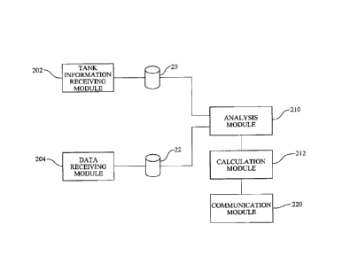
Referring now to the schematic representation of the core components in FIG.
IA, the
central processing facility includes the above-described databases 20, 22.
Furthermore, the
central processing facility hosts a digital computer program (i.e., computer-
readable instructions
executed by a processor of a computer) that includes appropriate modules for
executing the
requisite instructions (which are stored in a memory component) for performing
the operational
steps of the method described above. Alternatively, the above-described
databases 20, 22 could
be stored locally, for example, in a memory component associated with the
sensor acquiring the
three-dimensional data, and the digital computer program could be similarly
hosted locally in a
memory component associated with the sensor acquiring the three-dimensional
data. In either
case, an exemplary system for determining an amount of a commodity stored in
one or more
tanks in accordance with the present invention includes: (a) a tank
information receiving module
202 for receiving and processing tank information, including volume capacity
information,
storing such information in the database 20; (b) a data receiving module 204
for receiving three-
dimensional data sets representative of the one or more tanks, storing such
data sets in the
database 22; (c) an analysis module 210 for querying the databases 20, 22 and
analyzing the
three-dimensional data sets to determine a liquid level for each tank and/or
status of each tank;
(d) a calculation module 212 for calculating the amount of the commodity in
each tank based on
the determined liquid level and the volume capacity information from the
database 20 and/or for
=
CA 02985814 2017-11-10
WO 2016/187376 PCT/US2016/033184
making other determinations of status; and (e) a communications module 220 for
communicating
information about the commodity to a market participant.
Finally, although the above description focused on liquid energy commodities,
such as
crude oil, other commodities, such as water, could be similarly monitored
without departing from
the spirit and scope of the present invention.
One of ordinary skill in the art will recognize that additional embodiments
and
implementations are also possible without departing from the teachings of the
present invention.
This detailed description, and particularly the specific details of the
exemplary embodiments and
implementations disclosed therein, is given primarily for clarity of
understanding, and no
unnecessary limitations are to be understood therefrom, for modifications will
become obvious
to those skilled in the art upon reading this disclosure and may be made
without departing from
the spirit or scope of the invention.
31