Note: Descriptions are shown in the official language in which they were submitted.
CA 02990584 2017-12-21
DESCRIPTION
APPARATUS AND METHOD FOR ANALYSIS OF GEOPHYSICAL LOGGING
DATA OBTAINED BY USING GAMMA RAY LOGGING
Technical Field
= The present disclosure relates to an apparatus
and a method for analysis of geophysical logging data
obtained by using gamma ray logging and, more
particularly, to an apparatus and a method for analysis
of geophysical logging data obtained by using gamma ray
logging, the apparatus and method being configured to
analyze geophysical logging data of lithofacies of strata
in an area within a wide range based on data obtained by
using gamma ray logging when estimating lithofacies of
strata.
Background Art
= A conventional method to cluster information on
the lithofacies of strata according to a type and
condition of the lithofacies of strata has been mostly
performed by relying on an empirical judgement of few
specialist geologists. Consequentially, such a method has
shown limitations as a qualitative method because it is
not based on quantitative numerical value. In many other
areas, various methods have been attempted to cluster an
object in an objective and automated manner.
= In order to identify
petrophysical
characteristics of lithofacies of strata in a stratum,
there is a method to form geophysical logging data by
analyzing physicochemical properties of the stratum by
inserting a device into a borehole after digging the
borehole.
= Among geophysical logging data, especially,
properties reflecting petrophysical characteristics,
which are different from each other depending on a
structure, mineral composition of a rock, a sedimentary
structure, a fluid in an air gap, etc. Therefore,
various methods have been suggested to cluster a borehole
logging section into geologically significant stratum
1
CA 02990584 2017-12-21
units obtained by using a combination of properties of
borehole logging data. A unit of each stratum that
borehole logging data is clustered into according to a
combination of constant property value is called an
electrofacies. For classification of electrofacies for
the borehole logging section, methods to statistically
classify digitalized borehole logging data are divided in
cluster analysis and discriminant analysis techniques.
However, geophysical logging data for the above-stated
stratum is heavily dependent on subjective interpretation
depending on analyst's background knowledge, and
therefore, objectivity of the results thereof is
difficult to achieve. Particularly, for the analysis of
geophysical logging data for a certain stratum, analysis
is generally performed by using a printout or a terminal,
thereby meeting with a limitation of requiring long
working hours for analysis of the data.
= In addition, geophysical logging analysis
through statistical approaches currently being developed
have been studied merely on numerical analysis simply
based on statistics wherein no geological meanings are
given to elements in the data. Furthermore, geophysical
logging analysis through statistical approaches currently
being developed has been actually performed for the
analysis of a geophysical logging data of a single
borehole.
= In addition, up to now, analysis in a where a
geologist directly analyzes geophysical logging data
based on recorded data of a core has been performed, but
analysis in where core data is understood and
sedimentary environment is inferred based on the analysis
results of a geophysical logging data has not been
performed.
= To resolve such a problem, as disclosed in
Korean Patent No. 10-1148835 (cited invention), by
yielding geophysical logging data for lithofacies of
strata in an area in a wide range into results with high
reliability based on a few core data, an oil sand
reservoir estimation method is disclosed by using
2
CA 02990584 2017-12-21
statistical analysis of geophysical logging data in
estimating the lithofacies of strata.
= However, since the cited invention analyzes
data by using databased statistics in analyzing the data,
and restores in a vertical resolution unit electrofacies,
a degree of restoration may be changed depending on
composition of a database. In addition, in restoring
electrofacies, since both of significant and
insignificant strata are used, accuracy may be decreased
depending on composition of the strata. Accordingly, in
restoring electrofacies, there is a problem depending on
a database.
Disclosure
Technical Problem
= Therefore, the present disclosure is contrived
to resolve problems of the related art as described
above. An objective of the present disclosure is directed
to providing an apparatus and a method for analysis of
geophysical logging data obtained by using gamma ray
logging, the apparatus and method being configured to
analyze results of the geophysical logging data for
lithofacies of strata in an area within a wide range
based on data obtained by using gamma ray logging, by
analyzing geophysical logging data only for significant
strata through clustering and patterning the geophysical
logging data for the significant strata, thus promoting
efficiency of estimating lithofacies of strata.
= In addition, the present disclosure is directed
to providing an apparatus and a method for analysis of
geophysical logging data obtained by using gamma ray
logging, which can realize more precise analysis of
strata by analyzing geophysical logging data through
clustering, patterning, and formularizing of the
geophysical logging data.
Technical Solution
= In order to accomplish the above object, an
apparatus for analysis of geophysical logging data
obtained by using gamma ray logging includes a gamma ray
3
CA 02990584 2017-12-21
emission unit which emits gamma rays by nuclear
transition of atomic nuclei, a gamma ray transmission and
reception unit which allows the emitted gamma rays to
penetrate through an object and receives the gamma rays,
and a logging determination unit which receives
information on waveforms and wavelengths of the gamma
rays emitted by the gamma ray emission unit, and
information from the transmission and reception unit
following the penetration of the gamma rays through the
object, and produces geophysical logging data for which
the information on the speeds, waveforms and wavelengths
of the received gamma rays has been analyzed.
= The apparatus for analysis of geophysical
logging data obtained by using gamma ray logging further
includes an input unit which provides input means to
adopt necessary data only among clustered geophysical
logging data, a.display unit which displays analyzed
geophysical logging data, and a storage unit which stores
the analyzed geophysical logging data in a set of table
and graphical data.
= The analyzed geophysical logging data are for
clustering strata by using the information on the speeds,
waveforms, and wavelengths of the received gamma rays,
determining a stratum classified by the clustering as a
prescribed pattern, and formularizing the pattern.
= The formularizing of the pattern determines any
one of a dispersion and a straight line, wherein the
dispersion is a state that, by calculating a standard
deviation within a cluster, data between a start point
and an end point are scattered and the straight line is a
state that, by calculating the standard deviation within
the cluster, the data between the start point and the end
point are on a straight line.
= The determining of the pattern determines any
one among a cylindrical pattern that has a sharp top, a
base, and a flat type block shape, a funnel pattern that
is a type with sizes of particles being increased
gradually and having a sharp top, a bell pattern that is
a type with sizes of particles being decreased gradually
4
CA 02990584 2017-12-21
and having a sharp top, a symmetrical pattern with a
degree of coarseness of particles forming a shape that
sands flow down, and a serrated pattern that is a type
with a degree of coarseness of particles forming an
irregular serrated shape.
= A method for analysis of geophysical logging
data obtained by using gamma ray logging to accomplish an
objective as above with a gamma ray emission unit
emitting gamma rays by nuclear transition of atomic
nuclei, a gamma ray transmission and reception unit
allowing the emitted gamma rays to penetrate through an
object and receiving the gamma rays, and a logging
determination unit producing geophysical logging data and
analyzing by using the geophysical logging data
comprises: receiving data of gamma rays from the gamma
ray transmission and reception unit, producing
geophysical logging data obtained using gamma ray
logging, analyzing the geophysical logging data by using
a sequential K-means clustering algorithm, displaying the
analyzed geophysical logging data in a form of tables and
graphs, and storing the analyzed geophysical logging
data.
= The analyzing of the geophysical logging data
includes patterning a style of the geophysical logging
data, and formularizing the patterned geophysical logging
data.
= The formularizing of the patterned geophysical
logging data determines any one of a dispersion and a
straight line, wherein the dispersion is a state that, by
calculating a standard deviation within a cluster, data
between a start point and an end point are scattered, and
the straight line is a state that, by calculating the
standard deviation within the cluster, the data between
the start point and the end point are on a straight line.
= The patterning the style of the data determines
any one among a cylindrical pattern that has a sharp top,
a base, and a flat type block shape, a funnel pattern
that is a type with sizes of particles being increased
gradually and having a sharp top, a bell pattern that is
CA 02990584 2017-12-21
a type with sizes of particles being decreased gradually
and having a sharp top, a symmetrical pattern with a
degree of coarseness of particles forming a shape wherein
sand flows down, and a serrated pattern that is a type
with a degree of coarseness of particles forming an
irregular serrated shape.
Advantageous Effects
= An apparatus and a method for analysis of
geophysical logging data obtained by using gamma ray
logging according to the present disclosure has an effect
of promoting efficiency of estimating lithofacies of
strata by providing the apparatus and the method to be
configured to analyze results of the geophysical logging
data for lithofacies of strata in an area within a wide
range obtained based on data obtained by using gamma ray
logging, and by analyzing geophysical logging data only
for significant strata through clustering and patterning
the geophysical logging data for the significant strata.
= In addition, an apparatus and a method for
analysis of geophysical logging data obtained by using
gamma ray logging according to the present disclosure has
an effect of realizing more precise analysis of strata by
analyzing geophysical logging data through clustering and
patterning of the geophysical logging data.
Description of Drawings
= FIG. 1 is a block diagram illustrating
schematically components of an apparatus for analysis of
geophysical logging data obtained by using gamma ray
logging according to an embodiment of the present
disclosure.
= FIG. 2 is a flowchart illustrating a method of
analysis of geophysical logging data obtained by using
gamma ray logging according to an embodiment of the
present disclosure.
= FIG. 3 is a flowchart illustrating a process of
analyzing data of FIG. 2 according to an embodiment of
the present disclosure.
6
CA 02990584 2017-12-21
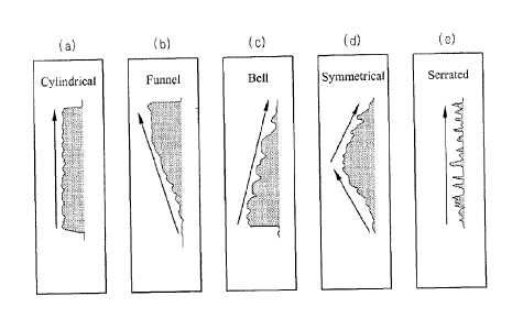
= FIGS. 4a to 4e are views illustrating types of
patterning of FIG. 3 according to an embodiment of the
present disclosure.
= FIGS. 5a to 5d are views illustrating the
analysis results in a table and graphs for the
geophysical logging data according to an embodiment of
the present disclosure.
Best Mode
= An exemplary embodiments according to a concept
of the present disclosure may be modified in various ways
and have many types, and some specific embodiments will
be illustrated in drawings and described in detail in
this specification or an application of the
specification. However, this is not intended to limit
embodiments according to a concept of the present
disclosure to a specific disclosure form and the
embodiments should be understood to include all
modifications, equivalents or substitutes that are
included in a concept and technical scope of the present
disclosure.
= When it is described that a component is
"coupled" or "connected" to another component, it should
be understood that the component is "coupled" or
"connected" to another component directly or via other
component therebetween. On the other hand, when it is
described that a component is "directly coupled" or
"directly connected" to another component, it should be
understood that no other component exists therebetween.
Other expressions describing relationship between
components such as "between _." and "directly between _"
or "neighboring to _" and "directly neighboring to _"
should be understood in the same manner.
= Terms used in the present specification are
merely to describe an exemplary embodiment and are not
intended to limit the present description. An expression
in a singular, unless meaning thereof is clearly
different in the context, includes the case of plural.
Terms used in the present specification such as "include"
7
CA 02990584 2017-12-21
or "have or has" should be understood to designate
existence of characteristics, a numeral, a step, an
action, a component, parts or combination thereof, but
not to exclude in advance existence or possibility of
addition of characteristics, a numeral, a step, an
action, a component, parts, or combination thereof.
= Hereinafter, an exemplary embodiment of the
present disclosure will be described in detail with
reference to the accompanying drawings. In the following
description of the present disclosure, detailed
descriptions of known functions and components
incorporated herein will be omitted when it may make the
subject matter of the present disclosure unclear.
= Hereinafter, the present disclosure will be
described in detail with reference to the accompanying
drawings illustrating an embodiment of the present
disclosure. FIG. 1 is a block diagram illustrating
schematically components of an apparatus for analysis of
geophysical logging data obtained by using gamma ray
logging according to an embodiment of the present
disclosure. Referring to FIG. 1, the present disclosure
is composed of a gamma ray emission unit 110, a gamma ray
transmission and reception unit 120, an input unit 140, a
logging determination unit 150, and a storage unit 160.
= The gamma ray emission unit 110 emits gamma
rays by nuclear transition of atomic nuclei of a Co-60.
= The gamma ray transmission and reception unit
120 allows the emitted gamma rays to penetrate an object,
for example, a borehole or strata, and receives the gamma
rays.
= The logging determination unit 150 receives
information such as wavelengths of the gamma rays emitted
by the gamma ray emission unit 110, and information from
the transmission and reception unit following the
penetration of the gamma rays through the object and
stores such information in the storage unit 160. The
logging determination unit 150 produces geophysical
logging data by analyzing information on speeds,
waveforms, and wavelengths of the received gamma rays.
8
CA 02990584 2017-12-21
= The logging determination unit 150 retrieves
data from the geophysical logging data and performs
clustering of retrieved data by automatic analysis.
Clustering is produced by using a sequential K-means
clustering algorithm and calculated in a manner such that
a variance of each cluster and a distance is minimized,
wherein the variance (V) can be obtained by using an
equation 1 as in the following.
= [Equation 1]
2
= where V represents the variance between the
cluster and distance, pi a center of an i-th cluster, Si a
set of points belonging to the cluster, and x: represents
a distance of a location of j-th borehole logging.
= An operator may adopt necessary data only
through the input unit 140 from geophysical logging data
clustered like this. That is, the input unit 140 allows
the operator to adopt the data as needed from the
clustered numerical and graphical data.
= The display unit displays analysis results of
geophysical logging data in a form of tables and graphs.
Meanwhile, the operator can make the logging
determination unit 150 display the relevant analysis
results by entering a command to display relevant
analysis results through the input unit 140 as necessary.
= The storage unit 160 stores the geophysical
logging data analyzed like this as data and the data can
be stored in the same form of stable and graphs as
displayed by the display unit. Analysis results of the
geophysical logging data can be stored in the form of
tables and graphs at the storage unit 160. Calculated
analysis result values are entered in a form of numerals
into the tables.
= FIG. 2 is a flow chart illustrating a method
of analysis of geophysical logging data obtained by using
gamma ray logging according to an embodiment of the
present disclosure. Referring to FIG. 2, at step S202,
the logging determination unit 150 receives gamma rays
9
CA 02990584 2017-12-21
through the gamma ray transmission and reception unit
120. At step S204, the logging determination unit 150
produces geophysical logging data obtained by using gamma
ray logging. Gamma ray data is information on speed,
waveform, and wavelength of the received gamma rays being
received and the logging determination unit 150 produces
geophysical logging data obtained by using gamma ray
logging.
= At step S206, the logging determination unit
150 analyzes the geophysical logging data. Analysis of
geophysical logging data that the logging determination
unit 150 performs is carried out by using a sequential K-
means clustering algorithm.
= At step S208, the logging determination unit
150 displays the analyzed geophysical logging data in a
form of tables and graphs through the display unit.
= At step S210, the logging determination unit
150 stores the geophysical logging data analyzed like
this in the storage unit 160. At this time, data stored
in the storage unit 160 can be stored in a form of tables
and graphs. Analysis results like these are stored such
that they can be verified afterwards. In addition, stored
data should be a set of files to be verifiable by using
different tool and compatibility thereof should be
maintained.
= FIG. 3 is a flow chart illustrating a process
of analyzing data of FIG. 2 according to an embodiment of
the present disclosure, FIGS. 4a to 4e are views
illustrating types of patterning of FIG. 3 according to
an embodiment of the present disclosure. Referring to
FIG. 3 and FIGS. 4a to 4e, at step S302, the logging
determination unit 150 performs patterning of style of
geophysical logging data. Patterning is performed on the
basis of the analyst's experience, and data having the
same type as FIGS. 4a to 4e are meaningful. This will be
described referring to FIGS. 4a tO 4e.
= Analysis results can be expressed as FIG. 4a to
FIG. 4e. FIG. 4a is a view illustrating that a classified
cluster having particles with a sharp top and a base or
CA 02990584 2017-12-21
shaped as a flat type block is classified as a
cylindrical pattern. FIG. 4b is a view illustrating that
a type with a degree of coarseness of particles being
increased gradually and having a sharp top is classified
as a funnel pattern. FIG. 4c is a view illustrating that
a type with a degree of coarseness of particles being
decreased gradually and having a sharp top is classified
as a bell pattern. FIG. 4d is a view illustrating that a
degree of coarseness of particles forming a shape that
sands flow down is classified as a symmetrical pattern.
FIG. 4e is a view illustrating that a degree of
coarseness of particles forming an irregular serrated
shape is classified as a serrated pattern.
= Referring to FIG. 3, at step S304, the logging
determination unit 150 mathematically formularizes a
patterned style. Classifying like this is set by the
operator and classifying is performed as follows by
mathematical equation to analyze the patterned style.
First, a standard deviation is calculated for data with
mean value as a reference within a single cluster. By
calculating the standard deviation, a state that many of
data are deviated from a straight line or some of data
are greatly deviated from a straight line can be
classified as dispersion as data between a start point
and an end point are scattered. By calculating the
standard deviation, when data between the start point and
the end point are on a straight line and points are not
deviated much from a relevant straight line, this state
can be classified as a straight line. From this, states
can be classified as in the Table 1 below.
11
CA 02990584 2017-12-21
[Tablel]
=
Straight Increase/Decrease Pattern
line/Dispersion
1 (Straight line) 1 (Increase) 3 (funnel)
2 (Maintenance) 2 (cylindrical)
4 (symmetrical)
3 (Decrease) 1 (bell)
2 (Dispersion) 1 (Increase) 3 (funnel)
2 (Maintenance) 2 (cylindrical)
4 (symmetrical)
3 (Decrease) 1 (bell)
= Next, a patterned style is formularized and
classified as a straight line when it is within a
predetermined range. However, since it is difficult to
define the predetermined range in advance, the operator
is allowed to change the range through the input unit
140.
= In addition, within a single cluster, by taking
a start point or an end point as a reference, a trend of
increase or decrease of numeral values is determined. At
this time, because a start point or an end point might
have been a type of data overly stuck out due to a noise,
therefore, a reference point may be generated by
averaging a certain number of points from the start point
or the end point, or by calibrating by a typical start
point or an end point by using before-and-after data of a
cluster. In the case of neither increase nor decrease, it
can be determined as a straight line, and a reference of
a certain numeral value is necessary to determine
increase/decrease and a straight line. A reference point
for an increase and a decrease can be set by the operator
through the input unit 140.
= At step S306, the logging determination unit
150 can also display the analysis results displayed in a
form of numerals in a form of graph. Identifying analysis
results in the form of numerals is difficult. Therefore,
by displaying analysis results in the form of graphs,
analysis results can be easily identified. A graph is
displayed by grouping the results depicted in
12
CA 02990584 2017-12-21
mathematical equation as described above whereby the
operator can recognize easily.
= FIGS. 5a to 5d are views illustrating a table
and graphs showing the analysis results for the
geophysical logging data according to an embodiment of
the present disclosure. Referring to FIGS. 5a to 5d, FIG.
5a is a view illustrating the analysis result values for
the geophysical logging data according to an embodiment
of the present disclosure in a form of the table.
Referring to FIG. 5a, it is a table being set in the
state that clusterings are shown as five in number, a
standard deviation reference for determination of a
straight line or dispersion is 10, and a reference for
determination of an increase or a decrease is 15.
= FIG. 5b is a graph illustrating the clustering
results. As illustrated in FIG. 5a, since five clusters
are grouped, FIG. 5b can be illustrated with zero to four
clusters. Forming a unit block while a value is
maintained on the graph is classified as one cluster.
That is, one layer being formed can be easily identified
over the range from where it starts to where it ends.
= When analysis progresses, it is performed by
the single cluster. Therefore the operator can confirm
and set the range of the cluster.
= FIG. 5c is a graph illustrating
a
type/pattern/class/category of analyzed data. In FIG.
Sc, values between 21 and 23 are shown as disclosed in
Table 1, wherein 21 means a straight linear increase, 22
means a straight linear maintenance, and 23 means a
straight linear decrease. The fact
that major data are
represented as a straight line may be understood that no
part of relevant data has vibration values or standard
deviation value taken as a reference is so large, thereby
being unable to identify the dispersion. Accordingly, in
this case, it is necessary for the operator to get more
accurate analysis results through iteration by reducing
standard deviation value until desired results are
produced.
13
CA 02990584 2017-12-21
= FIG. 5d illustrates raw data that are the data
before analysis is performed. The operator can make a
more accurate determination in reference with the raw
data in FIG. 5d. That is, the operator can use the raw
data as bases for the determination.
= An exemplary embodiments according to a concept
of the present disclosure may be modified in various ways
and have many types, some specific embodiments were
illustrated in drawings and described in detail in this
specification. However, this is not intended to limit
embodiments according to a concept of the present
disclosure to a specific disclosure form and the
embodiments should be understood to include all
modifications, equivalents or substitutes that are
included in a concept and technical scope of the present
disclosure.
=
14