Note: Descriptions are shown in the official language in which they were submitted.
CA 02995946 2018-02-16
WO 2017/065731
PCT/US2015/055122
MAGNETIC FIELD GRADIENT SENSOR CALIBRATION
Background
[0001] Magnetic ranging refers to well positioning that provides relative
direction and distance of one well with respect to another. Several
technologies
for ranging from a ranging well to a remote casing in a target well are based
upon launching an alternating current at a known frequency from a power supply
at the earth's surface down the casing of the target well in order to generate
a
magnetic field radiated from the target well casing. A sensor in the ranging
well
may detect the magnetic field and, thus, be able to determine a distance and
direction to the target well. Sensor measurement error may reduce the accuracy
of the ranging operation.
Brief Description of the Drawings
[0002] FIG. 1 is a diagram of an example ranging system, according to aspects
of the present disclosure.
[0003] FIG. 2 is a diagram of an example sensor tool apparatus for use in the
ranging well, according to aspects of the present disclosure.
[0004] FIG. 3 is a diagram of magnetic field components as received by the
sensor tool, according to aspects of the present disclosure.
[0005] FIG. 4 is a flowchart of an example method for calibration of the
sensor
tool as used in a ranging operation, according to aspects of the present
disclosure.
[0006] FIG. 5 is a diagram of an example drilling rig system, according to
aspects of the present disclosure.
[0007] FIG. 6 is a diagram of an example wireline system, according to aspects
of the present disclosure.
[0008] FIG. 7 is a block diagram of an example system operable to implement
the activities of multiple methods, according to various examples of the
disclosure.
Detailed Description
[0009] Some of the challenges noted above, as well as others, may be addressed
by implementing the apparatus, systems, and methods described herein. In many
1
CA 02995946 2018-02-16
=
WO 2017/065731
PCT/US2015/055122
examples, a sensor tool may be calibrated as disclosed herein to provide
improved accuracy in ranging operations. The examples described herein operate
to provide information that assists in determining relative distance and
direction
from one well to another. For example, determining the location of a target
well
(e.g., existing well) in relation to a ranging well (e.g., drilling well). The
examples described herein determine, on the surface, a sensor tool constant
coefficient (tool calibration coefficient) at different ranges of azimuth
angles
relative to an excitation source on the basis of laboratory data. The sensor
tool
measurements are then calibrated down hole by selecting the tool constant
coefficient corresponding to the azimuth angle relative to the target well
downhole.
[0010] A "target well" may be defined herein as a well, the location of which
is
to be used as a reference for the construction of another well. The other well
may
be defined as a "ranging well." Other embodiments may reverse this terminology
since the embodiments are not limited to any one well being the target well
and
any one well being the ranging well. The ranging well may be used in steam
assisted gravity drainage (SAGD), well intersection, relief well intersection,
well
avoidance, or any other usage where ranging, maintaining, avoiding, or
intersecting between two wells is desirable.
[0011] FIG. 1 is a diagram of an example ranging system, according to aspects
of the present disclosure. In this example, a target wellbore 110 is drilled
using
any suitable drilling technique. The target wellbore 110 may then be cased
with
a casing string 111.
[0012] A wellbore 112 (i.e., ranging well, drilling well) may then be drilled
using a bottom hole assembly (BHA) 114 that extends from a derrick 115. The
BHA 114 may be, for example, a logging-while drilling ("LWD") assembly, a
measurement while drilling assembly ("MWD") or other desired drilling
assembly. The BHA 114 may include a drilling motor 118 and a drill bit 120. A
drilling system is shown and described subsequently in greater detail with
reference to FIG. 5.
[0013] Although the ranging wellbore 112 is described as being subsequently
drilled, other examples may drill the target wellbore 110 and ranging wellbore
112 substantially simultaneously. Moreover, in yet another example, the BHA
114 may be embodied as a wireline application (without a drilling assembly) in
2
CA 02995946 2018-02-16
=
WO 2017/065731
PCT/US2015/055122
order to perform logging operations, as shown and described subsequently with
reference to FIG. 6.
[0014] In the illustrated example, the BHA/drilling assembly 114 includes a
sensor tool 116 having one or more electromagnetic field sensors and circuitry
for data communication to and from the surface. The sensor tool 116 is shown
and described subsequently in greater detail with reference to FIG. 2.
[0015] In an example ranging method, a source launches a signal (e.g.,
alternating current (AC) or direct current (DC) of approximately 0 ¨ 30 Hertz
and approximately 5-30 Amperes) down the casing 111 of the target wellbore
110. This may be accomplished by a connection 126 of an electric current
supply
124 (e.g., DC or AC power supply) to the target wellbore casing 111. The
casing
111 may then be considered the excitation source as used subsequently. In
another example, the source may be located downhole.
[0016] Measurements may be taken by the calibrated sensor tool 116, as well as
other tools, at various depth intervals in the ranging wellbore 112. These
measurements may include the magnitude, the direction and the radial gradient
of the electromagnetic field produced by the current flow on the target
wellbore
110. Other measurements may include the magnitude and the direction of the
Earth's magnetic field and the direction of gravity in the wellbore being
drilled
in order to determine the roll angle and inclination of the ranging wellbore
112.
As disclosed herein, data from these measurements may be used in determining a
relative distance and direction of the ranging wellbore 112 from the target
wellbore 110. Calibration of electromagnetic field measurements performed by
the sensor tool 116 is discussed subsequently.
[0017] FIG. 2 is a diagram of an example sensor tool apparatus for use in the
ranging well, according to aspects of the present disclosure. The sensor tool
116
is an electromagnetic field sensing instrument or magnetic gradiometer and
includes properties for making measurements of the radial electromagnetic
field
gradient.
[0018] The tool 116 includes a plurality of electromagnetic field sensors 201-
208, separated from each other, with axes of sensitivity substantially
perpendicular to the longitudinal axis of the tool 116. The tool 116 is shown
including eight primary electromagnetic field sensors 201-208 (i.e., induction
coil sensors, fluxgate magnetometers) substantially equally spaced around the
3
CA 02995946 2018-02-16
WO 2017/065731
PCT/US2015/055122
periphery of the tool 116. Other examples may use different quantities of
induction coil sensors 201-208. Each of these sensors 201-208 measures a
vector
component of the magnetic field in the direction of the arrows SAl-SA8. The
sensors 201-208, or at least pairs of sensors, may be substantially identical.
[0019] Each sensor 201-208 includes a respective induction coil 211-218. The
axes of the coils 211-218 are orientated perpendicular to a drilling axis 220
(i.e.,
longitudinally along the wellbore) and located radially from the axis of the
drilling tool, as far as mechanically possible, and as allowed by the BHA
diameter. In an example, the sensors 201-208 are located every 45 with
respect
to each other around the drilling axis 220. Such a configuration may result in
an
improved response to the radial electromagnetic field gradient from the
targeting
wellbore source. In addition, the sensors 201-208 can be also implemented by
fluxgate magnetometer to measure electromagnetic fields from the source down
hole.
[0020] The induction coil sensors 201-208 respectively generate output
demodulated DC voltages V1-V8 in response to a received magnetic field. In an
eight sensor tool, the voltages may be expressed as follows:
Vlcl V2c1 V8c1
1V1V2...V81=1H * cos H * sin G* cos20 G* sin20 I* Vls1 V2s1 V8s1
V1c2 V2c2 V8c2
Vls2 V2s2 V8s2
[0021] where Vicl-V8c1 and Vlsl-V8s1 are cosine and sine tool
constant coefficients respectively, //represents a uniform electromagnetic
field
component (sec FIG. 3), and G represents a gradient magnetic field component
(see FIG. 3) at the center of the sensor tool in the plane. The angle 0 is the
relative azimuthal angle between the ranging wellbore and the target wellbore.
This equation may be represented by VM = Hcs * CalMa__,,r4ne where Hcs
represents the magnetic field component cosine/sine terms and CaiMatfine
represents the calibration matrix, using known sensor tool measurements
azimuthal angles over a relatively small range (e.g., approximately < 90 )
that
covers the azimuthal angle, as described subsequently.
4
CA 02995946 2018-02-16
=
WO 2017/065731
PCT/US2015/055122
[0022] If the elements of the calibration matrix CaiMatfine are known, Hcs
can be solved with the measurements by the matrix calculation. Thus, the
distance , R, and relative angle, 9, of the ranging wellbore from the target
wellbore may be calculated with the items in Hcs as follows:
= arctan(Hcs(2)/Hcs(1))
H = VHcs(1)2 + Hcs(2)2
R= H I VHcs(3)2 +Hcs(4)2
[0023] Each respective sensor coil 211-218 may also be coupled to respective
circuitry that includes a low noise, high gain, amplifier 221-228 (e.g., low-
pass,
high-pass, band-pass). The amplifier voltages may be fed individually into a
controller for analysis of the different field components (see FIG. 3). The
voltages V1-V8 are proportional to the amplitude of the electromagnetic field
projection on each sensor's respective axis at each sensor's location.
[0024] The sensor tool apparatus 116 may further include a system for control
and calibration of the tool 116. For example, the system of FIG. 7 may be
included within the tool housing or located elsewhere and coupled to the
sensor
tool through telemetry. As described subsequently with reference to FIG. 7,
the
system may perform the calibration methods disclosed herein.
[0025] FIG. 3 is a diagram of magnetic field components as received by the
sensor tool, according to aspects of the present disclosure. The source 301 of
the
electromagnetic field (e.g., casing in target well) generates the total
electromagnetic field 300 to which the sensor tool 302 is exposed. This field
300
circulates around the target wellbore in accordance with the well-known right-
hand rule.
[0026] The total electromagnetic field 300 is a combination of a uniform
electromagnetic field component 310 and a gradient (i.e., correction)
electromagnetic field component 311. The uniform electromagnetic field
component 310 may be expressed as i/27ER and the gradient electromagnetic
field 311 may be expressed as P2nR2, where R represents the center-to-center
CA 02995946 2018-02-16
=
WO 2017/065731
PCT/US2015/055122
radial distance from the target wellbore to the ranging wellbore and I
represents
the current, in Amperes, on the target wellbore casing.
[0027] Imperfections in sensor tool manufacture can affect the response
voltages VI-V8 . Thus, the method disclosed herein provides a calibration of
the
sensor tool in order to improve the accuracy of the sensor tool measurements
in a
ranging operation. The method generates a calibration matrix, as described
subsequently, using a known azimuthal angle of the sensor tool relative to the
source and a relatively small range (e.g., approximately < 900) of azimuthal
angles in the calibration matrix. Thus, instead of generating a single tool
constant coefficient based on a range of 0 -360 , the method disclosed herein
generates a plurality of tool constant coefficients (i.e., tool constant
coefficient
library) based on the relatively smaller azimuth angle ranges (e.g.,
approximately
<90 ). An azimuth angle range of approximately 90 is for purposes of
illustration only as any angle range that is less than 360 will operate
properly to
implement most examples. Generally, the greater the quantity of azimuth angle
ranges used, the more accurate the calibration of the sensor tool.
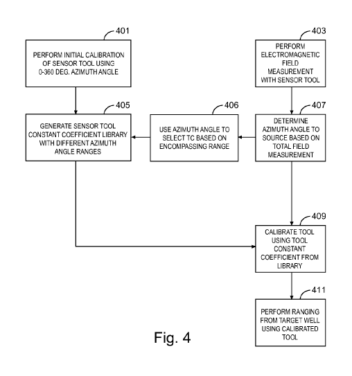
[0028] FIG. 4 is a flowchart of an example method for calibration of the
sensor
tool as used in a ranging operation, according to aspects of the present
disclosure. This method assumes the orientation between the target wellbore
and
the ranging wellbore as illustrated in FIG. 3. Namely, the sensor tool 302 in
the
ranging wellbore has a distance of R from the source 301 in the target
wellbore
and a relative azimuth angle of 0 from the source 301.
[0029] In block 401, the sensor tool is initially calibrated using an initial
0 -
360 azimuth angle relative direction angle of the sensor tool from the
source.
The initial calibration may be calculated with the total calibration matrix
shown
above or with another determination method. Using the data generated in block
401, a plurality of sensor tool constant coefficients (e.g., library of sensor
tool
constant coefficients) may be generated in block 405. The data generated in
block 401 may include a plurality of measurements of the magnetic field at
each
sensor of the sensor tool at different rotational positions of the sensor
tool.
[0030] In block 405, a plurality of tool constant coefficients (i.e., tool
constant
coefficient library) are generated, each tool constant coefficient associated
with a
different range of azimuth angles. For example, a first tool constant
coefficient
6
CA 02995946 2018-02-16
=
WO 2017/065731
PCT/US2015/055122
might cover azimuth angles in a range of 00-900, a second tool constant
coefficient might cover azimuth angles in a range of 91 480 , a third tool
constant coefficient might cover azimuth angles in a range of 1810-270 , and a
fourth tool constant coefficient might cover azimuth angles in a range of 271 -
3600. These angle ranges are for purposes of illustration only as other angle
ranges and other quantities of angle ranges are possible.
[0031] In block 403, the sensor tool performs an electromagnetic field
measurement of the electromagnetic field generated by the source. In block
407,
the total electromagnetic field (i.e., uniform field component and gradient
field
component) is used to generate an azimuth angle to the source without any
calibration. Determining this azimuth angle may be accomplished as described
previously.
[0032] Using this azimuth angle, the sensor tool constant coefficient library
is
accessed, in block 406, to determine the tool constant coefficient associated
with
the particular azimuth angle range that encompasses the azimuth angle.
[0033] As an example of operation, if the azimuth angle from the sensor tool
to
the source is determined to be approximately 30 , this angle is used in
accessing
the sensor tool constant coefficient library to determine that the first tool
constant coefficient, having a range of 00-900, encompasses the 30 azimuth
angle. Thus, the first tool constant coefficient is used, in block 409, in
performing the calibration (e.g., adjusting) of measurements from the sensor
tool. This example is for purposes of illustration only as the quantity of
different
azimuth angle ranges may vary with different examples and, thus, the
associated
tool constant coefficient may be different.
100341 In block 409, the sensor tool is calibrated using the tool constant
coefficient retrieved from the tool constant coefficient library. This
calibration
calibrates the tool's response to the uniform field component and/or the
gradient
field component of the total electromagnetic field. The calibration may be
performed using the following equations and includes adjusting the uniform and
gradient field measurements by the sensor too in response to the selected tool
constant coefficient. The matrices include measured voltages that are recorded
at
different known angles of rotation of the sensor tool:
7
= CA 02995946 2018-02-16
WO 2017/065731
PCT/US2015/055122
V11 V21 ... V81 H * cos(01) H * sin(01 ) G* cos(201 ) G*sin(20,
)
V12 V22 ... V82 H * cos(02) H *sin(02) G* cos(202) G*sin(202)
Vln V2n VU H * cos(09) H *sin(07) G* cos(20, ) G*sin(20, )
x CalMatfine
where N./ represents the voltage measured by the ith sensor of (V1-V8) at the
ith rotation angle (Of) and n is the total number of rotation angles.
[0035] Continuing the above example in which the tool comprises eight sensors
and an azimuth angle of 30 was determined in block 407, This equation can be
expressed as:
VII V21 ... V81 H*cos(-
30 ) H*sin(-300) G*cos(-600) G*sin(-600)
V12 V22 ... V82 H* cos(0 ) H*sin(0 ) G*cos(0 )
G*sin(0 )
V13 V23 ... V83 = H*cos(300) H*sin(300)
G*cos(600) G*sin(600)
V14 V24 ... V84 H* cos(60 ) H* sin(60 ) G* cos(120 )
G*sin(1200)
x CalMatfine
[0036] Once the sensor tool is calibrated using the tool constant coefficient,
a
ranging operation may be performed in block 411 using the calibrated tool. The
sensor tool, calibrated by one of a plurality of tool constants, may thus
provide
an azimuth angle and distance to the source in the target well.
[0037] FIG. 5 is a diagram showing a drilling system 564, according to various
examples of the disclosure. The system 564 includes a drilling rig 502 located
at
the surface 504 of a well 506. The drilling rig 502 may provide support for a
drillstring 508. The drillstring 508 may operate to penetrate the rotary table
510
for drilling the borehole 512 through the subsurface formations 514. The
borehole 512 may operate as either the ranging borehole or the target
borehole,
as illustrated in FIG. 1.
[0038] The drillstring 508 may include a drill pipe 518 and a bottom hole
assembly (BHA) 520 (e.g., drill string), perhaps located at the lower portion
of
8
CA 02995946 2018-02-16
=
WO 2017/065731
PCT/US2015/055122
the drill pipe 518. The BHA 520 may include drill collars 522, a down hole
tool
524 including the calibrated sensor tool 116, and a drill bit 526. The drill
bit 526
may operate to create the borehole 512 by penetrating the surface 504 and the
subsurface formations 514. The down hole tool 524 may comprise any of a
number of different types of tools besides the sensor tool 116. The sensor
tool
116, calibrated to the gradient field component as previously discussed, may
be
used in ranging operations for SAGD operations, well intersection, relief well
intersection, well avoidance, or any other usage where ranging, maintaining,
avoiding, or intersecting between two wells is desirable..
[0039] During drilling operations, the drillstring 508 (perhaps including the
drill pipe 518 and the BHA 520) may be rotated by the rotary table 510.
Although not shown, in addition to or alternatively, the BHA 520 may also be
rotated by a motor (e.g., a mud motor) that is located down hole. The drill
collars
522 may be used to add weight to the drill bit 526. The drill collars 522 may
also
operate to stiffen the bottom hole assembly 520, allowing the bottom hole
assembly 520 to transfer the added weight to the drill bit 526, and in turn,
to
assist the drill bit 526 in penetrating the surface 504 and subsurface
formations
514.
[0040] During drilling operations, a mud pump 532 may pump drilling fluid
(sometimes known by those of ordinary skill in the art as "drilling mud") from
a
mud pit 534 through a hose 536 into the drill pipe 518 and down to the drill
bit
526. The drilling fluid can flow out from the drill bit 526 and be returned to
the
surface 504 through an annular area 540 between the drill pipe 518 and the
sides
of the borehole 512. The drilling fluid may then be returned to the mud pit
534,
where such fluid is filtered. In some examples, the drilling fluid can be used
to
cool the drill bit 526, as well as to provide lubrication for the drill bit
526 during
drilling operations. Additionally, the drilling fluid may be used to remove
subsurface formation cuttings created by operating the drill bit 526.
[0041] As shown in FIG. 6, a workstation 592 including a controller 596 may
include modules comprising hardware circuitry, a processor, and/or memory
circuits that may store software program modules and objects, and/or firmware,
and combinations thereof, such as illustrated in FIG. 7, that are configured
to
execute the method of FIG. 4. For example, the workstation 554 with controller
596 may be configured to receive the voltages as measured by the sensor tool
at
9
CA 02995946 2018-02-16
=
WO 2017/065731
PCT/US2015/055122
different rotation angles and generate the plurality of tool constant
coefficients
that encompass a particular range of azimuth angles.
[0042] These implementations can include a machine-readable storage device
having machine-executable instructions, such as a computer-readable storage
device having computer-executable instructions. Further, a computer-readable
storage device may be a physical device that stores data represented by a
physical structure within the device. Such a physical device is a non-
transitory
device. Examples of machine-readable storage devices can include, but are not
limited to, read only memory (ROM), random access memory (RAM), a
magnetic disk storage device, an optical storage device, a flash memory, and
other electronic, magnetic, and/or optical memory devices.
[0043] FIG. 6 is a diagram showing a wireline system 664, according to
various examples of the disclosure. The system 664 may comprise a wireline
logging tool body 620, as part of a wireline logging operation, that includes
the
calibrated sensor tool 116 as described previously. This wellbore may operate
as
either a ranging well or a target well, as illustrated in FIG. 1.
[0044] A drilling platform 586 equipped with a derrick 588 that supports a
hoist 690 can be seen. Drilling oil and gas wells is commonly carried out
using a
string of drill pipes connected together so as to form a drillstring that is
lowered
through a rotary table 510 into a wellbore or borehole 512 as discussed
previously with reference to FIG. 5. Here it is assumed that the drillstting
has
been temporarily removed from the borehole 512 to allow the wireline logging
tool body 620, such as a probe or sonde with the sensor tool 116, to be
lowered
by wireline or logging cable 674 (e.g., slickline cable) into the borehole
512.
Typically, the wireline logging tool body 620 is lowered to the bottom of the
region of interest and subsequently pulled upward at a substantially constant
speed.
[0045] During the upward trip, at a series of depths, wireline data may be
collected from the calibrated sensor tool 116 in order determine a distance
and
angle relative to another well. The wireline data may be communicated to a
surface logging facility (e.g., workstation 592) for processing, analysis,
and/or
storage. The logging facility 592 may be provided with electronic equipment
for
various types of signal processing as described previously. The workstation
592
CA 02995946 2018-02-16
=
WO 2017/065731
PCT/US2015/055122
may have a controller 596 that is coupled to the sensor tool 116 through the
wireline 674 or telemetry in order to receive data from the sensor tool.
[0046] In both the drilling system and wireline system examples, the source
may be located on the surface and launch the signal to produce the
electromagnetic field down the casing. The source may also be located downhole
and the electromagnetic field produced downhole.
[0047] FIG. 7 is a block diagram of an example system 700 operable to
implement the activities of multiple methods, according to various examples of
the disclosure. The system 700 may include a tool housing 706 having the
sensor
tool 116 such as that illustrated in FIG. 2. The system 700 of FIG. 7 may be
implemented as shown in FIGs. 5 and 6 with reference to the workstation 592
and controller 596.
[0048] The system 700 may include circuitry such as a controller 720, a
memory 730, and a communications unit 735. The memory 730 may be
structured to include a database of sensor tool constant coefficients as
described
previously. The controller 720, the memory 730, and the communications unit
735 may be arranged to operate as a processing unit to control operation of
the
calibrated sensor tool 116 and execute any methods disclosed herein.
[0049] The communications unit 735 may include down hole communications
for appropriately located sensors in a wellbore. Such down hole communications
can include a telemetry system. The communications unit 735 may use
combinations of wired communication technologies and wireless technologies at
frequencies that do not interfere with on-going measurements.
[0050] The system 700 may also include a bus 737, where the bus 737
provides electrical conductivity among the components of the system 700. The
bus 737 can include an address bus, a data bus, and a control bus, each
independently configured or in an integrated format. The bus 737 may be
realized using a number of different communication mediums that allows for the
distribution of components of the system 700. The bus 737 may include a
network. Use of the bus 737 may be regulated by the controller 720.
[0051] The system 700 may include display unit(s) 760 as a distributed
component on the surface of a wellbore, which may be used with instructions
stored in the memory 730 to implement a user interface to monitor the
operation
of the tool 706 or components distributed within the system 700. Such a user
11
CA 02995946 2018-02-16
WO 2017/065731
PCT/US2015/055122
interface may be operated in conjunction with the communications unit 735 and
the bus 737. Many examples may thus be realized. A few examples of such
examples will now be described.
[0052] Example 1 is a method comprising: measuring, with a sensor tool, an
electromagnetic field generated by a source to determine an azimuth angle from
the sensor tool to the source; performing an initial calibration of the sensor
tool
to generate a plurality of sensor tool constant coefficients, each sensor tool
coefficient associated with a different range of azimuth angles; selecting a
sensor
tool constant coefficient from the plurality of sensor tool constant
coefficients
based on the azimuth angle from the sensor tool to the source; and calibrating
the
sensor tool based on the selected sensor tool constant coefficient.
[0053] In Example 2, the subject matter of Example 1 can further include
wherein selecting the sensor tool constant coefficient comprises selecting the
sensor tool constant coefficient associated with the range of azimuth angles
that
encompasses the azimuth angle from the sensor tool to the source.
[0054] In Example 3, the subject matter of Examples 1-2 can further include
performing a ranging operation from a target well using the calibrated sensor
tool.
[0055] In Example 4, the subject matter of Examples 1-3 can further include
wherein performing the ranging operation comprises determining the azimuth
angle and a distance to the source.
[0056] In Example 5, the subject matter of Examples 1-4 can further include
wherein performing the initial calibration of the sensor tool comprises
generating
a plurality of measurements of a magnetic field at each sensor of the sensor
tool,
at different rotational positions of the sensor tool.
[0057] In Example 6, the subject matter of Examples 1-5 can further include
wherein measuring, with the sensor tool, the electromagnetic field comprises
measuring a uniform field component and a gradient field component of the
electromagnetic field.
[0058] In Example 7, the subject matter of Examples 1-6 can further include
wherein calibrating the sensor tool comprises calibrating a response of the
sensor
tool to the uniform field component and the gradient field component.
[0059] In Example 8, the subject matter of Examples 1-7 can further include
wherein calibrating the response of the sensor tool comprises adjusting
uniform
12
CA 02995946 2018-02-16
WO 2017/065731
PCT/US2015/055122
field and gradient field measurements by the sensor tool in response to the
selected sensor tool constant coefficient.
[0060] In Example 9, the subject matter of Examples 1-8 can further include
wherein performing the initial calibration of the sensor tool comprises
calibrating the sensor tool using a 0 -360 azimuth angle relative direction.
[0061] Example 10 is an apparatus comprising: a plurality of electromagnetic
field sensors disposed around a periphery of the apparatus; and circuitry
coupled
to the plurality of electromagnetic field sensors to calibrate uniform field
and
gradient field measurements provided by the electromagnetic field sensors
based
on a selected one of a plurality of sensor tool constant coefficients, wherein
each
of the plurality of sensor tool constant coefficients is associated with a
different
range of azimuth angles of the apparatus from an excitation source.
[0062] In Example 11, the subject matter of Example 10 can further include
wherein the plurality of electromagnetic field sensors comprise induction coil
sensors.
[0063] In Example 12 the subject matter of Examples 10-11 can further
include wherein the plurality of electromagnetic field sensors comprise
fluxgate
magnetometers.
[0064] In Example 13, the subject matter of Examples 10-12 can further
include wherein the circuitry comprises memory to store a database of the
plurality of sensor tool constant coefficients and their associated,
respective
range of azimuth angles.
[0065] In Example 14, the subject matter of Examples 10-13 can further
include wherein the circuitry is to determine the selected one of the
plurality of
sensor tool constant coefficients in response to an azimuth angle between the
apparatus and the excitation source.
[0066] Example 15 is a system comprising: a target well comprising a casing;
an excitation source to produce an electromagnetic field; a sensor tool in a
ranging well, the sensor tool to measure a total electromagnetic field
including a
uniform field component and a gradient field component; and circuitry coupled
to the sensor tool to calibrate the uniform field and gradient field
measurements
from the sensor tool based on a selected one of a plurality of sensor tool
constant
coefficients, wherein each of the plurality of sensor tool constant
coefficients is
13
= CA 02995946 2018-02-16
WO 2017/065731
PCT/US2015/055122
associated with a different range of azimuth angles of the sensor tool from
the
target well.
[0067] In Example 16, the subject matter of Example 15 can further include
wherein the system further comprises a drill string and the sensor tool is
disposed in the drill string.
[0068] In Example 17, the subject matter of Examples 15-16 can further
include wherein the system further comprises a wireline tool and the sensor
tool
is disposed in the wireline tool.
[0069] In Example 18, the subject matter of Examples 15-17 can further
include wherein the sensor tool comprises a plurality of sensors, each sensor
having a sensor coil coupled to an amplifier.
[0070] In Example 19, the subject matter of Examples 15-18 can further
include wherein each sensor is to generate a voltage that is proportional to
an
amplitude of the electromagnetic field projection on its respective axis.
[0071] In Example 20, the subject matter of Examples 15-19 can further
include wherein the circuitry is further to select the tool constant
coefficient
based on an azimuth angle between the sensor tool and the target well.
[0072] The accompanying drawings that form a part hereof, show by way of
illustration, and not of limitation, specific embodiments in which the subject
matter may be practiced. The embodiments illustrated are described in
sufficient
detail to enable those skilled in the art to practice the teachings disclosed
herein.
Other embodiments may be utilized and derived therefrom, such that structural
and logical substitutions and changes may be made without departing from the
scope of this disclosure. This Detailed Description, therefore, is not to be
taken
in a limiting sense, and the scope of various embodiments is defined only by
the
appended claims, along with the full range of equivalents to which such claims
are entitled.
14