Note: Descriptions are shown in the official language in which they were submitted.
CA 02999920 2018-03-22
WO 2017/058723 PCT/US2016/053750
3D SEISMIC ACQUISITION
FIELD OF THE DISCLOSURE
[0001] The disclosure generally relates to marine seismic data
acquisition.
BACKGROUND OF THE DISCLOSURE
[0002] Seismic surveys have become the primary tool of exploration
companies in the
continental United States, both onshore and offshore. As an example, an
onshore seismic
survey is conducted by creating a shock wave¨a seismic wave¨on or near the
surface of
the ground along a predetermined line, using an energy source. The seismic
wave travels
into the earth, is reflected by subsurface formations, and returns to the
surface where it is
recorded by receivers called geophones¨similar to microphones. By analyzing
the time it
takes for the seismic waves to reflect off of subsurface formations and return
to the surface,
a geophysicist can map subsurface formations and anomalies and predict where
oil or gas
may be trapped in sufficient quantities for exploration activities.
[0003] Until relatively recently, seismic surveys were conducted along a
single line on the
ground, and their analysis created a two-dimensional picture akin to a slice
through the
earth beneath that line, showing the subsurface geology along that line. This
is referred to
as two-dimensional or 2D seismic data.
[0004] Currently, almost all oil and gas exploratory wells are preceded by
3D seismic
surveys. The basic method of testing is the same as for 2D, but instead of a
single line of
energy source points and receiver points, the source points and receiver
points onshore are
commonly laid out in a grid across the property. The resulting recorded
reflections received
at each receiver point come from all directions, and sophisticated computer
programs can
analyze this data to create a three-dimensional image of the subsurface.
[0005] Conceptually, 3D surveys are acquired by laying out energy source
points and
receiver points in a grid over the area to be surveyed. The receiver points¨to
record the
reflected vibrations from the source points¨are commonly laid down in parallel
lines
1
CA 02999920 2018-03-22
WO 2017/058723 PCT/US2016/053750
(receiver lines), and the source points are laid out in parallel lines that
are typically
approximately perpendicular to the receiver lines. Although orthogonal layouts
are
preferred, non-orthogonal layouts are sometimes used as well. The spacing of
the source
and receiver points is determined by the design and objectives of the survey.
They may be
several hundred feet apart, or as close as 15 feet.
[0006] In marine seismic surveys the survey design is a little different,
and instead of a
static set of lines, a vessel tows behind it a series of streamers, each
having a series of
hydrophones along its length. See e.g., FIG. 1A and FIG. 1B. Also towed behind
the
vessel are one or more seismic sources.
[0007] A variety of seismic sources are available for marine applications,
including water
guns (20-150 Hz), Air Gun (10-150 Hz), Sparkers (50-4000 Hz), Boomers (30-300
Hz),
and Chirp Systems (500 Hz-12 kHz, 2-7 kHz, 4-24 kHz, 3.5 kHz, and 200 kHz),
but air
guns are by far the most common.
[0008] The streamers also have depth control "birds" programmed to pivot
their wings in
response to hydrostatic pressure, thus keeping the streamers at a constant
depth, as well as
"paravanes" to minimize lateral deviation, described in more detail below. One
of the most
critical elements of 3D marine seismic systems is positioning. Thus, the
vessel also tows
one or more tail-buoys that house a differential global positioning receiver
used to
accurately position each of the hydrophones and additional navigation pods
(GPS units and
transceivers) are located on the paravanes, gun arrays and pretty much any
other location
that one can mount them above the surface of the water. Also, noise
attenuation algorithms
are now available (see e.g., Q-marine single sensor technology) that allow the
collection of
useful data, even when sailing in curves.
[0009] A seismic vessel with 2 sources and towing a single streamer is
known as a Narrow-
Azimuth Towed Streamer (aka "NAZ" or "NATS"). By the early 2000s, it was
accepted
that this type of acquisition was useful for initial exploration, but
inadequate for
development and production, in which wells had to be accurately positioned.
This led to
the development of the Multi-Azimuth Towed Streamer or "MAZ," which tried to
break
the limitations of the linear acquisition pattern of a NATS survey by
acquiring a
2
CA 02999920 2018-03-22
WO 2017/058723 PCT/US2016/053750
combination of NATS surveys at different azimuths (see FIG. 2). This
successfully
delivered increased illumination of the subsurface and a better signal to
noise ratio.
[0010] The seismic properties of salt poses an additional problem for
marine seismic
surveys, as it attenuates seismic waves and its structure contains overhangs
that are difficult
to image. This led to another variation on the NATS survey type, the wide-
azimuth towed
streamer (aka "WAZ" or "WATS"), which was first tested on the Mad Dog field in
2004.
See FIG. 3. This type of survey involved a single vessel towing a set of 8
streamers and
two additional vessels towing seismic sources that were located at the start
and end of the
last receiver line (see diagram). This configuration was "tiled" 4 times, with
the receiver
vessel moving further away from the source vessels each time and eventually
creating the
effect of a survey with 4 times the number of streamers. The end result was a
seismic
dataset with a larger range of wider azimuths, delivering a breakthrough in
seismic
imaging.
[0011] Another common acquisition pattern for 3D seismic marine surveys is
the
"racetrack" vessel pattern, wherein the survey has a single line orientation
(or "survey
azimuth"), and a long, narrow spread of streamers are towed by a single
vessel. Typically,
a vessel equipped with one or two airgun sources and towing 8-10 streamers
travels in a
straight line through the survey area. When it reaches the edges of the survey
area, it
continues in a straight line for one half the length of a streamer then turns
in a wide arc to
travel in a straight line back and parallel to the first run. With each
subsequent run, the
racetrack like course is displaced laterally from the last run, until the
entire area has been
covered.
[0012] The racetrack pattern is shown FIG. 4, wherein the acquisition path
follows a
straight line (blue arrow) then turns 180 to acquire data in the opposite
direction (orange
arrow). No data are normally recorded during line turns (black) because the
streamers do
not maintain their lateral separation during turns and the position of the
receivers cannot
be accurately calculated. Further, there is known to be increased noise during
turns due to
dragging the streamer through the water somewhat sideways.
[0013] Recently, surveyors have developed a coil pattern, involving
circles that gradually
shift in the desired direction¨a development made possible with Q-marine
single sensor
3
CA 02999920 2018-03-22
WO 2017/058723 PCT/US2016/053750
technology. See Biva (208). Compared to prior acquisition patterns, the coil
pattern
delivered a higher number of contributions (yellow and red) for a complete
range of
azimuths for all offsets. See FIG. 5. Further, with parallel geometries,
vessels are
productive about 45% of the time, but with a coiled geometry, they are
productive about
90% of the acquisition time.
[0014] During pre-processing, positional data gathered in the field is
used to compute a
theoretical grid network called a binning grid. Every individual recorded
seismic trace is
assigned to one or more bins; the number of traces summed together at each bin
is called
the fold or coverage for that bin. The nominal average fold for the survey is
part of the
descriptive information for the survey. Summing all the traces assigned to
each bin creates
a single multi-fold trace that is used as input to subsequent seismic
processing steps. The
general rule of thumb is that 3-4 bins are required to map the smallest
(narrowest)
horizontal dimension of a stratigraphic feature that must be seen in the 3D
data volume.
See e.g., FIG. 6. Thus, the geophones in a land-based survey are set at the
optimal spacing
to allow for 3-4 bin coverage of the smallest feature to be mapped.
[0015] However, in marine surveys, the normal approach is to select the
bin grid size
based upon the spacing of the sensors in the cables and the spacing of the
streamers in the
water. Since sensor spacing is fixed at the time of manufacture, most (if not
all) marine
seismic surveys are acquired at some multiple 12.5 meters (m). Thus, a common
bin size
is 6.25 m by 25 m or 12.5 m by 12.5 m. If geophysically one only needed a 16 m
bin grid,
the conventional approach would be to oversample at 12.5 m. However, this is
expensive
and wasteful, since these surveys can take months to perform. This
conventional
"racetrack" pattern generates a very uniform distribution of data over the
project, but it is
wasteful from a compressed seismic imaging approach as the survey acquires an
excess of
data that is unneeded.
[0016] Thus, what is needed in the art is a better method of establishing
the bin grid pattern
in marine 3D seismic surveys that optimizes data acquisition over the survey
area, and
doesn't needlessly cover or over-cover the geological features to be mapped.
4
CA 02999920 2018-03-22
WO 2017/058723 PCT/US2016/053750
SUMMARY OF THE DISCLOSURE
[0017] The present disclosure describes a better method of survey design
that avoids or
minimizes collecting unneeded data, and allows the vessel to sail with the
wind or currents,
instead of compensating for same to maintain straight lines for data
collection.
[0018] The first step in implementing the disclosure is to select a trial
bin grid of a
geophysically determined size. Commonly, we determine this size by bin
aliasing rules of
the maximum frequency. Conventional surveys would then round to the next
smaller
standard bin size, but in this disclosure this is no longer necessary.
[0019] The next step is to use the geologic model for the project area and
determine the
stability of the Compressed Seismic Imaging (CSI) designs given the bin grid
and geologic
model. While all bin grids will result in a CSI design for a geologic model,
some are not
as stable, so it may be necessary to modify the bin size or orientation and re-
determine the
CSI design iteratively to locate a stable solution. This process of
establishing the proper
CSI design is addressed in U58897094 and US201108011354277, which are
incorporated
by reference in their entirety for all purposes.
[0020] The next step with the proper designs determined and the offset or
similar attributes
determined, is to establish a set of rules, which again will be unique to the
region and the
CSI algorithm applied. These rules would be the rules for acquisition and
might be, for
example, that in no region more than 3 bins can be missing two unique offset
planes in a
row or that no more than 15% of the unique offset planes can be void of
traces. The rules
would apply to the coverage and distributions of the seismic data that will be
acquired in
the next step and basically define what constitutes a fully acquired dataset.
The rules we
have used to date tend to relate to gaps in coverage and orientation and
distribution of the
trace data when compared from one bin to another bin in the survey and over an
areal
region.
[0021] The next step with the rules in hand is to acquire the seismic
data. Because the rules
don't require a conventional uniform grid of offsets and azimuths like a
conventional
survey, there is no particular requirement that the survey needs to be
acquired in a
conventional racetrack approach or other regular pattern approach. This also
implies that
CA 02999920 2018-03-22
WO 2017/058723 PCT/US2016/053750
unlike a conventional survey where it is customary to acquire the data in a
uniform spacing,
in the CSI design, the station spacing is normally not uniform.
[0022] There are a few patents like this US20130250720 (random source
activation/spacing) and US8681581 (randomizing distribution of receivers and
sources) &
US8711654 (random survey locations) that address random style acquisition. CSI
techniques are not random, however, and require that the shots be placed at
the pre-
determined optimal positions. Simply put CSI approaches have an imaging
algorithm and
technique implicit to their design. Therefore there exists a single optimal
solution for the
particular CSI approach applied that will result in the best image. Many
solutions will
work but are all sub-optimally. Using a random approach, it is statistically
unlikely to
consistently come up with the optimal solution. Thus, the CSI design approach,
while not
uniform, is much better than these random approaches, which result in a sub-
optimal
solution.
[0023] In actuality, it is likely that the survey would be acquired as a
series of cross-cutting
passes of the vessel at different orientations due to shifting winds,
currents, tides and the
like. Again, since the surveyor is not required to shoot a racetrack or other
regular pattern,
there is no reason (unless the rules require it) that the vessel would not
acquire the data into
and out of the wind for ease of operation or e.g., with the current. This will
be beneficial,
because it will allow faster surveys and reduce noise, which is known be
highest when
shooting across currents.
[0024] If the winds change, the vessel would just move with the wind. No
efforts need be
made to avoid drift off a preset pathway, and instead, the actually pathway is
tracked and
compared against the desired rule set to ensure all rules are met. By
continuing to shoot
until the rules laid out above are met and all of the gaps are closed, the
concept of infill is
eliminated. The concept of fighting the currents and tides to generate a
straight racetrack
pattern is eliminated and the surveyor just acquires data without fighting
Mother Nature.
The conventional paradigm of marine seismic acquisition is thus obviated and
the vessel
meanders according to the wind and currents until the rules are met and full
coverage is
obtained.
6
CA 02999920 2018-03-22
WO 2017/058723 PCT/US2016/053750
[0025] The concept for this invention was developed while shooting in the
arctic and
dealing with icebergs, currents, winds and tides. Conventional approaches
resulted in a
great deal of standby time to find the exact right conditions where the
icebergs were clear
of the next transit path, while the winds and tides would not force the
steamers into other
icebergs. The solution was to acquire the data using the inventive method
where one would
acquire data in and out of the wind, tide and current direction and then dodge
around the
icebergs that could be drifting in many directions. Icebergs depending on
their size can be
moved by different currents at different depths so it is not uncommon for them
to move in
oblique directions if one is smaller than the rest. The inventive method
allows near
continuous acquisition by working around the obstacles and working with the
winds and
current instead of standing by waiting for better conditions.
[0026] The technical and economic advantage is that this method allows to
design and
process surveys that would optimal in terms of costs for the required
geophysics at a
significantly cheaper costs than conventional approaches, which oversample and
collect
unneeded data.
[0027] As used herein, "design" refers to the precise source and receiver
locations for the
data acquired. These locations are determined in the CSI imaging step prior to
data
acquisition.
[0028] By "Compressed Seismic Imaging (CSI) design" herein we mean using
the
compressed sensing imaging concepts and apply them specifically to seismic
layout,
acquisition, and processing and all of the inherent limitations of seismic
data collection like
airgun recharge rates and towing issues etc.
[0029] By "stability" herein we refer to the overall mathematical
consistency of a solution
or process. A technique that demonstrates stability will converge on the same
answer from
many different starting points.
[0030] By "stable CSI design," what is meant is a CSI design that
demonstrates stability,
e.g., will converge on the same answer from multiple starting points.
[0031] By "allowing wind and current to direct travel" we mean
intentionally allowing
wind and current to direct vessel path at least a significant portion of
sailing time, e.g. about
7
CA 02999920 2018-03-22
WO 2017/058723 PCT/US2016/053750
25%, 30%, 40% or so. Thus is to be distinguished from efforts to travel in a
particular grid
pattern, wherein the wind and current may occasionally direct travel, but the
operator
actively attempts to counteract this, keeping any drifting to a minimum such
that a
particular survey path, such as racetrack, can be obtained. Thus, accidental
wind and
current drift is not included under this understanding of the term.
[0032] The use of the word "a" or "an" when used in conjunction with the
term
"comprising" in the claims or the specification means one or more than one,
unless the
context dictates otherwise.
[0033] The term "about" means the stated value plus or minus the margin of
error of
measurement or plus or minus 10% if no method of measurement is indicated.
[0034] The use of the term "or" in the claims is used to mean "and/or"
unless explicitly
indicated to refer to alternatives only or if the alternatives are mutually
exclusive.
[0035] The terms "comprise", "have", "include" and "contain" (and their
variants) are
open-ended linking verbs and allow the addition of other elements when used in
a claim.
[0036] The phrase "consisting of' is closed, and excludes all additional
elements.
[0037] The phrase "consisting essentially of' excludes additional material
elements, but
allows the inclusions of non-material elements that do not substantially
change the nature
of the invention.
BRIEF DESCRIPTION OF THE DRAWINGS
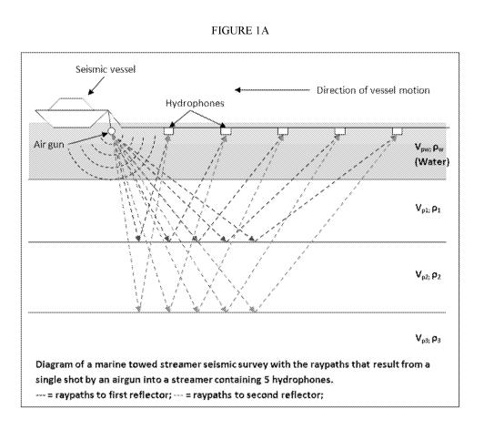
[0038] FIG. 1A is a side view of a marine seismic survey vessel and
seismic waves.
[0039] FIG. 1B is a top view of a typical seismic vessel and streamers.
[0040] FIG. 3 shows a Narrow Azimuth towed streamers.
[0041] FIG. 3 shows a Multi-Azimuth towed streamers.
[0042] FIG. 4 displays the traditional racetrack pattern of acquiring
marine 3D seismic
data.
[0043] FIG. 5 comparing coverage obtained with various acquisition
geometries.
8
CA 02999920 2018-03-22
WO 2017/058723 PCT/US2016/053750
[0044] FIG. 6 shows bin spacing for optimal 3-4 bin coverage of the
smallest feature to be
mapped. Geophones are thus set to achieve this bin spacing.
DETAILED DESCRIPTION
[0045] The disclosure provides novel methods of acquiring seismic data,
which eliminates
oversampling, infill and the need to fight wind and current to provide a
straight line data.
[0046] Specifically, the methods herein described allow for the design and
acquisition of
marine seismic surveys using a rule-based mode without need for conventional
designs that
result in wasted coverage. This will decrease the cost of acquiring data
because of the
smaller sampling size and ease of determining when enough data has been
collected and
accelerate modeling times by decreasing the presence of unneeded data points.
[0047] The invention includes one or more of the following embodiments, in
any
combination thereof:
[0048] ¨A method of acquiring marine 3D seismic data comprising acquiring
3D data of
an area to be surveyed without compensating for wind and current, but instead
allowing
wind and current to direct travel, collecting data positioning data while
acquiring 3D data,
and continuing until said collected positioning data indicates that sufficient
coverage of
said area has been obtained.
[0049] ¨A method of marine 3D seismic data acquisition, comprising:
obtaining a marine
geology model of a marine survey area; determining a bin size and orientation
based on a
smallest feature to be mapped and a shape of said marine geology model;
determine a
stability of a compressed Seismic Imaging (CSI) design and if unstable modify
said source
& receiver station spacing and location, bin size or orientation and re-
determine said
stability of said CSI design iteratively to locate a stable solution for said
CSI design;
establish a set of rules for coverage of said marine survey area that meet the
CSI design;
and acquiring 3D seismic data over said marine survey area until said rules
are met, wherein
wind and current are not compensated for but allowed to direct vessel travel
and or streamer
shape at least a portion of the time.
[0050] ¨A method of imaging a marine 3D survey area, comprising: obtaining
or
developing a geology model of a marine survey area; determining a bin size and
9
CA 02999920 2018-03-22
WO 2017/058723 PCT/US2016/053750
orientation based on a smallest feature to be mapped and a shape of said
marine geology
model; determining a stability of a compressed seismic imaging source and
receiver
station and sampling design ("CSI design"), and if unstable modify said bin
size or
orientation and re-determine said stability iteratively to produce a stable
CSI design;
establishing a set of sampling rules for coverage of said marine survey area
to assure that
appropriate data is recorded so said stable CSI design can be properly
reconstructed;
acquiring 3D seismic data traces over said marine survey area using said
stable CSI
design until said rules are met, wherein wind and current are not compensated
for but
allowed to direct vessel travel; reconstructing a wavefield and regularizing
the traces
using the appropriate reconstruction techniques to produce seismic data. In
some method,
the further steps of processing the seismic data and imaging the survey area
are also
included.
[0051] ¨A method of acquiring marine 3D seismic data comprising: acquiring
3D seismic
data of an marine area to be surveyed without compensating for wind and
current, but
instead allowing wind and current to direct >25% of said travel; collecting
data
positioning data while acquiring 3D data; and continuing said acquiring step
until said
collected positioning data indicates that sufficient coverage of said marine
area has been
obtained such that a seismic map of said marine area can be constructed from
said 3D
seismic data. The wind and current may direct most of vessel travel, e.g., >
50% or >
75%, even when shifting.
[0052] ¨A method as herein described, wherein sufficient coverage is
determined by the
following steps: obtaining or developing a geology model of a marine survey
area;
determining a bin size and orientation based on a smallest feature to be
mapped and a
shape of said geology model; determining a stability of a CSI design and if
unstable
modify said bin size or orientation and re-determine said stability of said
CSI design
iteratively to locate a stable solution and produce a stable CSI design;
establishing a set
of sampling rules for coverage of said survey area to assure that appropriate
data is
recorded so the CSI design can be properly reconstructed; and acquiring 3D
seismic data
traces over said marine survey area using the stable CSI design until said
rules are met,
wherein wind and current are not compensated for but allowed to direct vessel
travel; and
CA 02999920 2018-03-22
WO 2017/058723 PCT/US2016/053750
reconstructing a wavefield and regularizing said traces using appropriate
reconstruction
techniques to produce seismic data.
[0053] ¨A method as herein described, including the further step of
processing the
seismic data using conventional techniques and imaging said survey area.
[0054] ¨A method as herein described, wherein said CSI design is determined
by a
method comprising: constructing an optimization model, via a computing
processor,
given by mina Su Iii s.t. II Ru¨b II 2cr wherein S is a discrete transform
matrix, b is
seismic data on an observed grid, u is seismic data on a reconstruction grid,
and matrix
R is a sampling operator; defining mutual coherence as:
=C
.õQQ;, ,QQQQQQQQQQQQQQQQQ.
s. aomr
wherein C is a constant, S is a cardinality of Su, m is proportional to number
of seismic
traces on the observed grid, and n is proportional to number of seismic traces
on the
reconstruction grid; deriving a mutual coherence proxy, wherein the mutual
coherence
proxy is a proxy for mutual coherence when S is over-complete and wherein the
mutual
coherence proxy is exactly the mutual coherence when S is a Fourier transform;
and
determining a sample grid according to r*=arg minr 1,t(r).
[0055] ¨A method as herein described, wherein the sample grid is determined
via
randomized greedy algorithm method, and/or a randomized greedy algorithm
method
finds local minimum.
[0056] ¨A method as herein described, wherein the sample grid is determined
via a
stochastic global optimization method.
[0057] ¨A method as herein described, wherein r*=arg minr 1,t(r) is non-
convex.
[0058] ¨A method as herein described, wherein the mutual coherence proxy is
derived
using fast Fourier transform.
11
CA 02999920 2018-03-22
WO 2017/058723 PCT/US2016/053750
[0059] ¨A method as herein described, wherein collected traces or data are
analyzed in
real time or near real time to confirm sufficient coverage and that said rules
have been
met.
[0060] ¨A method as herein described, wherein an actual pathway travelled
is mapped
and used to thereby confirm sufficient coverage and that said rules have been
met.
[0061] ¨Any method described herein, including the further step of
printing, displaying
or saving the results of the method.
[0062] ¨A printout or 3D display of the results of the method.
[0063] ¨A non-transitory machine-readable storage medium containing or
having saved
thereto the seismic imaging results of the method.
[0064] ¨Any method described herein, further including the step of using
said results in
a seismic modeling program to predict e.g., reservoir performance
characteristics, such as
fracturing, production rates, total production levels, rock failures, faults,
wellbore failure,
and the like.
[0065] ¨Any method described herein, further including the step of using
said results to
design and implement a reservoir drilling, development, production or
stimulation
program.
[0066] ¨A non-transitory machine-readable storage medium, which when
executed by at
least one processor of a computer, performs the steps of the method(s)
described herein.
[0067] The present disclosure also relates to a computing apparatus for
performing the
operations herein. This apparatus may be specially constructed for the
required purposes
of modeling, or it may comprise a general-purpose computer selectively
activated or
reconfigured by a spreadsheet program and reservoir simulation computer
program
stored in the computer. Such computer programs may be stored in a computer
readable
storage medium, preferably non-transitory, such as, but is not limited to, any
type of disk
including floppy disks, optical disks, CD-ROMs, and magnetic-optical disks,
read-only
memories (ROMs), random access memories (RAMs), EPROMs, EEPROMs, magnetic
or optical cards, or any type of media suitable for storing electronic
instructions, each
coupled to a computer system bus.
12
CA 02999920 2018-03-22
WO 2017/058723 PCT/US2016/053750
[0068] In one embodiment, the computer system or apparatus may include
graphical user
interface (GUI) components such as a graphics display and a keyboard, which
can include
a pointing device (e.g., a mouse, trackball, or the like, not shown) to enable
interactive
operation. The GUI components may be used both to display data and processed
data and
to allow the user to select among options for implementing aspects of the
method or for
adding information about reservoir inputs or parameters to the computer
programs. The
computer system may store the results of the system and methods described
above on
disk storage, for later use and further interpretation and analysis.
Additionally, the
computer system may include on or more processors for running said spreadsheet
and
simulation programs.
[0069] Hardware for implementing the inventive methods may preferably
include
massively parallel and distributed Linux clusters, which utilize both CPU and
GPU
architectures. Alternatively, the hardware may use a LINUX OS, XML universal
interface run with supercomputing facilities provided by Linux Networx,
including the
next-generation Clusterworx Advanced cluster management system.
[0070] Another system is the Microsoft Windows 7 Enterprise or Ultimate
Edition (64-bit,
SP1) with Dual quad-core or hex-core processor, 64 GB RAM memory with Fast
rotational speed hard disk (10,000-15,000 rpm) or solid state drive (300 GB)
with
NVIDIA Quadro K5000 graphics card and multiple high resolution monitors.
[0071] Slower systems could also be used, but are not preferred because
the method is
already compute intensive.
[0072] The term "many-core" as used herein denotes a computer
architectural design
whose cores include CPUs and GPUs. Generally, the term "cores" has been
applied to
measure how many CPUs are on a giving computer chip. However, graphic cores
are
now being used to offset the work of CPUs. Essentially, many-core processors
use both
computer and graphic processing units as cores.
MARINE SURVEY EQUIPMENT
[0073] FIG. 1B shows an overhead view of a marine survey system 100 in
accordance
with at least some embodiments of the invention, wherein paravanes are used to
control
13
CA 02999920 2018-03-22
WO 2017/058723 PCT/US2016/053750
streamer positioning. In particular, FIG. 1B shows a survey vessel 102 having
onboard
equipment 104, such as navigation, energy source control, and data recording
equipment.
Survey vessel 102 is configured to tow one or more sensor streamers 106A-F
through the
water and one or more sources 130 (one shown here). While FIG. 1
illustratively shows
six streamers 106, any number of streamers 106 may be equivalently used. In
other
surveys, ocean bottom cables (OBC) or ocean bottom nodes (OBN, cable free
receivers)
are used instead, thus obviating many towed streamer issues.
[0074] The streamers 106 are coupled to towing equipment that maintains
the streamers
106 at selected lateral positions with respect to each other and with respect
to the survey
vessel 102. The towing equipment may comprise two paravane tow lines 108A and
108B
each coupled to the vessel 102 by way of winches 110A and 110B, respectively.
The
winches enable changing the deployed length of each paravane tow lines 108.
The second
end paravane tow line 108A is coupled to a paravane 112, and the second end of
paravane
tow line 108B is coupled to paravane 114. In each case, the tow lines 108A and
108B
couple to their respective paravanes through respective sets of lines called a
"bridle".
[0075] The paravanes 112 and 114 are each configured to provide a lateral
force
(transverse to the direction of motion) component to the various elements of
the survey
system when the paravanes are towed in the water, as will be explained below.
The lateral
force component of paravane 112 is opposed to that of paravane 114. For
example,
paravane 112 may create a force as illustrated by arrow 116, and the lateral
component of
force 116 is shown by arrow 117. Likewise, paravane 114 may create a force as
illustrated
by arrow 118, and the lateral component of force 118 is shown by arrow 119.
The combined
lateral forces of the paravanes 112 and 114 separate the paravanes from each
other until
they put one or more spreader lines 120, coupled between the paravanes 112 and
114, into
tension. The paravanes 112 and 114 either couple directly to the spreader line
120, or as
illustrated couple to the spreader line by way of spur lines 122A and 122B.
[0076] The streamers 106 are each coupled, at the ends nearest the vessel
102 to a
respective lead-in cable termination 124A-F. The lead-in cable terminations
124 are
coupled to or are associated with the spreader lines 120 so as to control the
lateral positions
of the streamers 106 with respect to each other and with respect to the vessel
102. It should
14
CA 02999920 2018-03-22
WO 2017/058723 PCT/US2016/053750
be noted that the spacings between 106 can be uniform or non-uniform depending
on the
CSI implementation chosen. Electrical and/or optical connections between the
appropriate
components in the recording system 104 and the sensors (e.g., 109A, 109B) in
the
streamers 106 may be made using inner lead-in cables 126A-F. Much like the tow
lines
108 associated with respective winches 110, each of the lead-in cables 126 may
be
deployed by a respective winch or similar spooling device such that the
deployed length of
each lead-in cable 126 can be changed.
[0077] During periods of time when the survey vessel 102 is traveling in
an approximately
straight line, the speed of the paravanes 112 and 114 through the water is
approximately
the same, and thus the lateral force created by similarly configured paravane
112 and 114
may be approximately the same. However, when the survey vessel 102 executes a
turn
(e.g., a 180 degree turn to align the vessel for the next pass over the survey
area), the
paravane on the outside of the turn tends to move faster through the water
than the paravane
on the inside of the turn, the providing greater lateral force than paravane
112. The
paravanes also compensate somewhat for water currents.
[0078] The paravanes 112 and 114 can have adjustable lateral force, such
that the tension
on the spreader lines 120 can be controlled. The paravanes 112 and 114
according at least
some embodiments comprise systems to controllably redirect the flow of water
past the
paravane, and/or adjust the angle of attack to control the amount of lateral
force developed.
Angle of attack for purposes of this disclosure and claims shall be a
relationship between
the direction of motion of the tow vessel 102 and a long dimension of one or
more frames
(described below) of the paravane.
[0079] FIG. 1B shows the angle of attack (AoA) for the illustrative
situation of FIG. 1.
Such control may be helpful in a variety of situations, such as during turns.
COMPRESSIVE SENSING
[0080] A common goal of the engineering field of signal processing is to
reconstruct a
signal from a series of sampling measurements. In general, this task seems
impossible
because there is no way to reconstruct a signal during the times that the
signal is not
measured. Nevertheless, with prior knowledge or assumptions about the signal,
it turns out
CA 02999920 2018-03-22
WO 2017/058723 PCT/US2016/053750
to be possible to perfectly reconstruct a signal from a series of
measurements. Over time,
engineers have improved their understanding of which assumptions are practical
and how
they can be generalized.
[0081] An early breakthrough in signal processing was the Nyquist¨Shannon
sampling
theorem. It states that if the signal's highest frequency is less than half of
the sampling rate,
then the signal can be reconstructed perfectly. The main idea is that with
prior knowledge
about constraints on the signal's frequencies, fewer samples are needed to
reconstruct the
signal.
[0082] Around 2004, Emmanuel Candes, Terence Tao, and David Donoho proved
that
given knowledge about a signal's sparsity, the signal may be reconstructed
with even fewer
samples than the sampling theorem requires. This idea is the basis of
compressed sensing.
Compressive sensing is described in further detail in 61/898,960 filed
November 1, 2013,
and US20150124560, each incorporated by reference herein in its entirety for
all purposes.
See also U58681581 and US20130250720. A short summary is presented herein, and
the
reader is referred to the above cases for additional detail.
[0083] Compressed sensing is a signal processing technique for efficiently
acquiring and
reconstructing a signal, by finding solutions to underdetermined linear
systems. This is
based on the principle that, through optimization, the sparsity of a signal
can be exploited
to recover it from far fewer samples than required by the Shannon-Nyquist
sampling
theorem. There are two conditions under which recovery is possible. The first
one is
sparsity, which requires the signal to be sparse in some domain. The second
one is
incoherence which is applied through the isometric property which is
sufficient for sparse
signals.
[0084] Two classes of optimization models, synthesis- and analysis-based
optimization
models, are considered. For the analysis-based optimization model, a novel
optimization
algorithm (SeisADM) is presented. SeisADM adapts the alternating direction
method with
a variable-splitting technique, taking advantage of the structure intrinsic to
the seismic data
reconstruction problem to help give an efficient and robust algorithm. SeisADM
is
demonstrated to solve a seismic data reconstruction problem for both synthetic
and real
data examples. In both cases, the SeisADM results are compared to those
obtained from
16
CA 02999920 2018-03-22
WO 2017/058723 PCT/US2016/053750
using a synthesis based optimization model. Spectral Projected Gradient Li
solver
(SPGL1) method can be used to compute the synthesis-based results.
[0085] Through both examples, it is observed that data reconstruction
results based on the
analysis-based optimization model are generally more accurate than the results
based on
the synthesis-based optimization model. In addition, for seismic data
reconstruction, the
SeisADM method requires less computation time than the SPGL1 method.
[0086] Compressive sensing can be successfully applied to seismic data
reconstruction to
provide a powerful tool that reduces the acquisition cost, and allows for the
exploration of
new seismic acquisition designs, such as that described herein. Most seismic
data
reconstruction methods require a predefined nominal grid for reconstruction,
and the
seismic survey must contain observations that fall on the corresponding
nominal grid
points. However, the optimal nominal grid depends on many factors, such as
bandwidth of
the seismic data, geology of the survey area, and noise level of the acquired
data. It is
understandably difficult to design an optimal nominal grid when insufficient
information
is available. In addition, it may be that the acquired data contain
positioning errors with
respect to the planned nominal grid. An interpolated compressive sensing
method is thus
presented, which is capable of reconstructing the observed data on an
irregular grid to any
specified nominal grid, provided that the principles of compressive sensing
are satisfied.
The interpolated compressive sensing method provides an improved data
reconstruction
compared to results obtained from some conventional compressive sensing
methods.
[0087] Compressive sensing is utilized for seismic data reconstruction and
acquisition
design. Compressive sensing theory provides conditions for when seismic data
reconstruction can be expected to be successful. Namely, that the cardinality
of
reconstructed data is small under some, possibly over-complete, dictionary;
that the
number of observed traces are sufficient; and that the locations of the
observed traces
relative to that of the reconstructed traces (i.e. the sampling grid) are
suitably chosen. If the
number of observed traces and the choice of dictionary are fixed, then
choosing an optimal
sampling grid increases the chance of a successful data reconstruction.
[0088] To that end, a mutual coherence proxy is considered which is used
to measure how
optimal a sampling grid is. In general, the computation of mutual coherence is
prohibitively
17
CA 02999920 2018-03-22
WO 2017/058723 PCT/US2016/053750
expensive, but one can take advantage of the characteristics of the seismic
data
reconstruction problem so that it is computed efficiently. The derived result
is exact when
the dictionary is the discrete Fourier transform matrix, but otherwise the
result is a proxy
for mutual coherence. The mutual coherence proxy in a randomized greedy
optimization
algorithm is used to find an optimal sampling grid, and show results that
validate the use
of the proxy using both synthetic and real data examples.
[0089] One example of a computer-implemented method for determining
optimal
sampling grid during seismic data reconstruction includes: a) constructing an
optimization
model, via a computing processor, given by:
minIt Su s.t. I Ru b a
wherein S is a discrete transform matrix, b is seismic data on an observed
grid, u is
seismic data on a reconstruction grid, and matrix R is a sampling operator; b)
defining
mutual coherence:
USin
S (lognY'
wherein C is a constant, S is a cardinality of Su, m is proportional to number
of seismic
traces on the observed grid, and n is proportional to number of seismic traces
on the
reconstruction grid; c) deriving a mutual coherence proxy, wherein the mutual
coherence
proxy is a proxy for mutual coherence when S is over-complete and wherein the
mutual
coherence proxy is exactly the mutual coherence when S is a Fourier transform;
and d)
determining a sample grid:
= arg nunt, ,u(r)
=
In some embodiments, the sample grid is determined via randomized greedy
algorithm
method, and the randomized greedy algorithm method finds local minimum. In
others,
the sample grid is determined via stochastic global optimization method. In
still other
18
CA 02999920 2018-03-22
WO 2017/058723 PCT/US2016/053750
ara min u(r)
embodiments,
" = = is non-convex. In yet others, the mutual coherence
proxy is derived using fast Fourier transform.
DATA ACQUISITION METHOD
[0090]
In rule-based modeling, a set of rules is used to indirectly specify a
mathematical
model. The rule-set can either be translated into a model such as Markov
chains or
differential equations, or be treated using tools that directly work on the
rule-set in place
of a translated model, as the latter is typically much bigger. Rule-based
modeling is
especially effective in cases where the rule-set is significantly simpler than
the model it
implies, meaning that the model is a repeated manifestation of a limited
number of patterns.
[0091]
The present method establishes an independent bin grid of some geophysically
selected size that is used to determine the needed locations of the source and
receivers to
properly populate the area to obtain an accurate image of the data. Once the
locations are
determined, specific project rules for the seismic acquisitions can be
developed and applied
in the field to determine if additional data needs to be acquired. Thus, only
the needed data
is acquired, and expense is saved in avoiding over-acquiring excess data.
[0092]
The first step to implementing the method is to select a trial bin grid of a
geophysically determined size. Bin grids are created during seismic trace
processing by
calculating the theoretical common mid point (usually called CMP) locations
for each shot
¨ receiver pair and then summing the traces together based on a mathematical
gridding
algorithm. Thus, the size of the bin grid is based upon the spacing of the
sensors in the
cables and the spacing of the streamers in the water. When the bin grid size
matches the
area of interest, then an appropriate amount of sampling is obtained. However,
for larger
or smaller areas, oversamples occurs resulting in the accumulation of
unnecessary data
points the slow down processing and analysis of the seismic data.
[0093]
The geologic model for the selected trial bin grid is used to estimate the
stability of
a Compressed Seismic Imaging (CSI) design. Using prior knowledge of the likely
geology
in the targeted region an overall geologic model is constructed. Using the
sampling
spacings or station layouts is then tested against the proposed CSI design to
test the stability
of the solution. This process is effectively repeated for all possible CSI
approaches for the
19
CA 02999920 2018-03-22
WO 2017/058723 PCT/US2016/053750
particular design and then the best sampling is selected that results in the
maximum mutual
incoherence.
[0094] Once the proper design and their offsets are determined, rules can
be developed.
The set of rules will be unique to the chosen region and to the CSI algorithm
that is applied,
but in effect are a measure of how badly can the data be sampled and still
properly
reconstruct the correct wavefield and image. These rules mainly cover the
rules for
acquisition of data, such as no region greater than 3 bins can be missing two
unique offset
planes in a row. Other rules relating to gaps in coverage or orientation of
the shot/receivers
and/or distribution of the trace data can also be developed. These rules are
necessary to
make sure that the minimum required data to properly reconstruct the wavefield
using CSI
techniques are collected in the field. The normal approach for creation of the
rules is to
take the perfectly acquired CSI design and then start decimating various
attributes like
sampling until the final image degrades. In the chosen example of 3 bins in a
row missing
2 unique offset planes, depending on the CSI design, if 3 unique offset planes
in a row are
missing data then the solution is degraded and an artifact in the final
process image is
created. This creates a rule that when acquiring the data must be met or
acquisitions
continue until it is met and the survey is completed.
[0095] Unlike a conventional marine survey, the rules-based method does
not require a
uniform grid of offsets and azimuths. Thus, the survey can be collected using
whichever
pattern is quickest, cheapest, and most reliable. Series or cross-cutting
passes of the vessel
at different orientations due to winds and tides are expected to be the best
pattern for
collecting data.
[0096] If winds change, the surveying ship can simply move with the wind
instead of trying
to maintain a set pattern such as the racetrack approach. Thus, time and money
can be saved
by utilizing nature to collect data instead of fighting currents and tides to
adhere to a rigid
collection pattern. In effect, although the ship may attempt to collect the
data is some
predetermined pattern, it need not stick to that pattern as wind and current
change are not
problematic, thus, a degree of meandering can be tolerated, and even a high
degree of what
appears to be meandering. However, from the view-point of the data
acquisition, the
CA 02999920 2018-03-22
WO 2017/058723 PCT/US2016/053750
operator will not be meandering but simply driving where needed to cover the
field, and
not fighting wind and currents to do so.
[0097] By continuing to shoot until the rules are met, the resulting
survey will have no
gaps and no infill, or at least un-needed infill will be substantially
reduced. This will aid in
reducing modeling time and cost. On the other hand, there may be areas where
there is a
surplus of data acquired because of the way the tides and winds worked out.
These
oversampled areas are a byproduct of not standing by for weather and winds and
follow
the goal of excess data is better than no data and paying to wait on weather.
[0098] In order to know that sufficient coverage has been obtained to meet
the rules, the
data will either be analyzed in real time or near real time, or one can track
the actual
pathway travelled, and thereby confirm sufficient coverage.
[0099] A variety of commercially available acquisition and tracking
programs can be used
herein. See e.g., the Omni 3D Design package, NORSAR-3D modeling package, the
Nucleus software package, Globe claritas, Delph, Seismix, and the like.
[00100] While the invention is described above in detail, it should be
understood that various
changes, substitutions, and alterations can be made without departing from the
spirit and
scope of the invention as defined by the following claims. Those skilled in
the art may be
able to study the preferred embodiments and identify other ways to practice
the invention
that are not exactly as described herein. It is the intent of the inventors
that variations and
equivalents of the invention are within the scope of the claims while the
description,
abstract and drawings are not to be used to limit the scope of the invention.
The invention
is specifically intended to be as broad as the claims below and their
equivalents.
[00101] The following references are incorporated by reference in their
entirety.
[00102] Buia M. et al., Shooting Seismic Surveys in Circles, Oilfield
Review, Autumn
2008:18-31.
[00103] Wang Y., Recovery of Seismic Wavefields Based on Compressive
Sensing by an
11-Norm Constrained Trust Region Method and the Piecewise Random Sub-sampling
Geophys. I Int. (2010) 000, 1-19.
[00104] 61/898,960, filed November 1, 2013, and U520150124560 Compressive
sensing
21
CA 02999920 2018-03-22
WO 2017/058723 PCT/US2016/053750
[00105] US20100265799 Compressive sensing system and method for bearing
estimation
of sparse sources in the angle domain
[00106] US8681581 Randomization of data acquisition in marine seismic and
electromagnetic acquisition
[00107] US20130250720 Method for acquiring marine seismic data
[00108] US8711654 Random sampling for geophysical acquisitions
[00109] US8897094 L Marine seismic data acquisition using designed non-
uniform
streamer spacing
[00110] US201108011354277
[00111] W02012166737 Two-way wave equation targeted data selection for
seismic
acquisition of complex geologic structures
[00112] US2012300585 Reciprocal method two way wave equation targeted data
selection
for seismic acquisition of complex geologic structures
[00113] US20120014212 Continuous composite relatively adjusted pulse
[00114] US5079703 3-dimensional migration of irregular grids of 2-
dimensional seismic
data
[00115] What is claimed is:
22