Note: Descriptions are shown in the official language in which they were submitted.
CONDUCTIVITY-DEPTH TRANSFORMS OF ELECTROMAGNETIC TELEMETRY
SIGNALS
BACKGROUND
In the field of well drilling and logging, resistivity logging tools are
frequently used to
provide an indication of the electrical resistivity of rock formations
surrounding an earth
borehole. Such information regarding resistivity is useful in ascertaining the
presence or
absence of fluids, such as hydrocarbons. A typical electromagnetic propagation
resistivity
logging tool includes at least one transmitting antenna and multiple receiving
antennas located
to at
different distances from the transmitter antenna along the axis of the tool.
The transmitting
antenna generates electromagnetic fields in the surrounding formation, which
in turn induce a
response in each receiving antenna. Due to geometric spreading and absorption
by the
surrounding earth formation, the responses in the receiving antennas have
different phases and
amplitudes. Examples of such resistivity logging while drilling (LWD) tools
include Sperry
Drilling's EWR , and ADRIM services. However, in some drilling operations, it
may be
economically infeasible for operators to run such tools in every well, leaving
them without any
direct measurements of formation resistivities around the borehole.
BRIEF DESCRIPTION OF THE DRAWINGS
zo
Accordingly, there are disclosed in the drawings and the following description
conductivity-depth transforms for use with methods and systems employing an
electromagnetic telemetry tool. In the drawings:
FIG. 1 is a schematic diagram showing an illustrative logging scenario.
FIG. 2A is a simplified schematic representation of a gap subassembly.
FIG. 2B is another simplified schematic representation of a gap subassembly.
FIG. 3 is a schematic diagram showing an illustrative logging scenario.
FIG. 4 is a schematic diagram showing a simplified illustrative logging
scenario.
FIG. 5 is a flowchart showing an illustrative logging method employing an
electromagnetic logging tool.
FIG. 6 is a graph showing illustrative signal levels received during an
illustrative
logging scenario.
FIG. 7 is a graph showing an illustrative resistivity profile.
It should be understood, however, that the specific embodiments given in the
drawings
-1 -
CA 3000149 2019-06-21
CA 03000149 2018-03-27
WO 2017/078708
PCT/US2015/059075
and detailed description thereto do not limit the disclosure. On the contrary,
they provide the
foundation for one of ordinary skill to discern the alternative forms,
equivalents, and
modifications that are encompassed together with one or more of the given
embodiments in the
scope of the appended claims.
DETAILED DESCRIPTION
Disclosed herein are methods and systems employing electromagnetic (EM)
telemetry
signals for generating formation resistivity logs. For example, received
telemetry signals may
be used to determine the formation resistivity along a wellbore. This
determination of the
formation resistivity does not require running a resistivity logging-while-
drilling (LWD) tool
(e.g., a tool that includes at least one transmitting antenna and multiple
receiving antennas
located at different distances from the transmitter antenna along the axis of
the tool). Using the
received telemetry signals may involve processing of real-time telemetry data
and/or processing
of post-drilling telemetry data. As such, in situations where resistivity logs
were not previously
generated, it may be possible to generate resistivity logs by re-processing
historical telemetry
datasets.
In at least some embodiments, a method includes disposing a transmitter at a
first
measured depth, measuring a first signal level in response to the transmitter
being at the first
measured depth, and determining a first conductance based on the first signal
level. The method
further includes disposing the transmitter at a second measured depth greater
than the first
measured depth, the second measured depth and the first measured depth
defining a formation
interval there between. The method further includes measuring a second signal
level in response
to the transmitter being at the second measured depth, determining a second
conductance based
on the second signal level, and assigning a uniform resistivity value to the
formation interval
based on the first conductance and the second conductance. A related system
includes an
electromagnetic telemetry tool that transmits an electromagnetic signal as the
tool is conveyed
along a borehole through a formation. The system further includes a processing
system that
measures a first signal level in response to the tool being at a first
measured depth, determines a
first conductance based on the first signal level, and measures a second
signal level in response
to the tool being at a second measured depth greater than the first measured
depth, the second
measured depth and the first measured depth defining a formation interval
there between. The
processing system further determines a second conductance based on the second
signal level,
and assigns a uniform resistivity value to the formation interval based on the
first conductance
- 2 -
CA 03000149 2018-03-27
WO 2017/078708
PCT/US2015/059075
and the second conductance.
FIG. 1 shows an illustrative logging while drilling scenario. In FIG. 1, a
drilling assembly
12 enables a drill string 30 to be lowered and raised in a borehole 22A that
penetrates formations
21 of the earth 20. The drill string 30 includes a plurality of drill string
segments 32 joined by
S tool joints or connectors 34. At the lower end of the drill string 30, a
bottom hole assembly 24
(BHA) with a drill bit 25 removes material and penetrates the formations 21
using known drilling
techniques. The BHA 24 may include, for example, thick-walled tubulars called
drill collars,
which add weight and rigidity to aid the drilling process. The thick walls of
these drill collars
make them useful for housing instrumentation and LWD sensors. In at least some
embodiments,
1.0 the BHA 24 includes a logging tool 26 with a telemetry/control unit 28.
The logging tool 26 may also include one or more sensors 27 to measure
parameters such
as bit weight, torque, wear and bearing conditions. Additionally, parameters
such as pressure
and temperature as well as a variety of other environmental and formation
information may be
obtained by the sensors. A signal generated by the sensors 27 may typically be
analog, which
1.5 may be converted to digital data before electromagnetic transmission in
the present system. The
signal generated by sensors 27 is passed into an electronics package (not
shown) including an
analog-to-digital converter which converts the analog signal to a digital code
utilizing "ones''
and "zeros" for information transmission.
The electronics package may also include electronic devices such as an on/off
control, a
20 modulator, a microprocessor, memory and amplifiers. The electronics
package may be powered
by a battery pack which may include a plurality of batteries, such as nickel
cadmium or lithium
batteries, which are configured to provide proper operating voltage and
current.
Once the electronics package establishes the frequency, power and phase output
of the
information, the electronics package feeds the information to
telemetry/control unit 28, which
25 includes electronics for data storage, communication, etc. The
information collected by the
logging tool 26 is then carried uphole to the earth's surface in the form of
modulated EM signals
which propagate through the earth. The collected data may also be stored by
the
telemetry/control unit 28.
In either case, the collected data can be analyzed as a function of position
and/or time to
30 .. determine properties of the formations 21. Moreover, the EM telemetry
signals themselves can
be used to determine formation resistivity as a function of position and/or
time. Such resistivity
information can be used, for example, to derive a saturation log as a function
of position, to track
movement of downhole fluids, and/or monitor other formation properties, The
logs and/or
- 3 -
CA 03000149 2018-03-27
WO 2017/078708
PCT/US2015/059075
formation properties derived from collected data and the EM telemetry signals
may be displayed
to an operator via computer 40.
In FIG. 1, an interface 14 at earth's surface for borehole 22A receives EM
telemetry data
from the BHA 24. In some embodiments, the surface interface 14 and/or a
computer system 40
may perform various operations such as converting received signals from one
format to another,
storing telemetry data, processing telemetry data, deriving logs from the
telemetry data, and/or
displaying logs or other visualization of telemetry data. The computer 40 may
also be used to
store, process, and visualize resistivity logs derived from EM telemetry
signals.
In at least some embodiments, the computer system 40 includes a processing
unit 42 that
performs telemetry analysis operations by executing software or instructions
obtained from a
local or remote non-transitory computer-readable medium 48. The computer
system 40 also may
include input device(s) 46 (e.g., a keyboard, mouse, touchpad, etc.) and
output device(s) 44 (e.g.,
a monitor, printer, etc.). Such input device(s) 46 and/or output device(s) 44
provide a user
interface that enables an operator to interact with the logging tool 26 and/or
software executed
by the processing unit 42. For example, the computer system 40 may enable an
operator may
select telemetry analysis options, to view collected telemetry data, to view
telemetry analysis
results, and/or to perform other tasks.
Formation evaluation is performed to achieve accurate well placement to
maximize
reservoir value, and while formation resistivity is regarded as being
particularly helpful for this
purpose, it is not always feasible to include a LWD resistivity tool in the
BHA. However, it is
often feasible to include an EM telemetry module in the BHA for communicating
to/from the
earth surface (e.g., BHA 24 of FIG. 1). EM telemetry enables the operator to
closely monitor
drilling dynamics data to achieve faster drilling. EM telemetry systems
typically operate at
frequencies between 1 and 50 Hz, with data rates nominally between 3 and 12
bps from a limited
number of communication channels. As demonstrated herein, the EM telemetry
signals may also
be used to derive a formation resistivity log.
As will be described in more detail below, transmission of an EM telemetry
signal may
involve applying a voltage across a gap subassembly in the BHA. At the earth
surface, an
electromagnetic field is sensed with electrodes or magnetic field sensors. The
wellhead may
serve as one electrode, while an electrode spaced 10 m to 100 m away serves as
a second
electrode. A receiver coupled between the electrodes may sense the voltage
between them,
thereby obtaining the EM telemetry signal.
-4-
As described earlier with reference to FIG. 1, the BHA 24 includes a logging
tool 26 with
a telemetry/control unit 28. The telemetry/control unit 28 may include a gap
subassembly,
toroid, or magnetic dipole that serves as a transmitter antenna. The unit 28
may further include a
separate receiver antenna, or the transmitter antenna may serve both roles.
FIG. 2A is a simplified schematic representation of a gap subassembly that may
be
included in the telemetry/control unit 28. An insulating gap 206 is located in
a drill string 202
having a drill bit 204. A power source 208 applies an alternating voltage
signal across the
insulating gap 206, producing an electromagnetic signal 212 that propagates
outward through the
formation, attenuated by currents induced in conductive portions of the
formation. For the
purposes of modeling, the voltage signal may be assigned an amplitude of a
nominal value (e.g.,
1V).
During drilling operations (e.g., LWD operations), the drill string (e.g.,
drill string 30,
drill string 202) is gradually inserted into the borehole as the borehole is
extended, causing the
BHA 24 (including the telemetry/control unit 28) to become disposed at various
measured depths
within the borehole 22A while it operates to transmit and/or receive EM
telemetry signals.
Because the borehole may twist and bend, the measured depth (i.e., the
distance the BHA has
traveled) does not necessarily correspond to true vertical depth (TVD), but
navigational
instruments are employed to track the unit's current position. At least some
differences in the
measured depths may correspond to various vertical distances with respect to a
location of a well
.. head of the borehole 22A. Other differences in measured depths may
correspond to various
horizontal distances with respect to the location of the well head.
FIG. 2B is another simplified schematic representation of a gap subassembly.
With
reference to FIG. 2B, an alternating voltage signal is applied across the
insulating gap 206. In
the schematic representation of FIG. 2B, the generation of the resulting
electromagnetic signal is
illustrated as a transmitter 210.
FIG. 3 is a schematic diagram showing an illustrative logging while drilling
scenario.
With reference to FIG. 3, the drill string 30 is lowered such that the BHA 24
is disposed, at
different times, at measured depths of 200 meters (m), 500 m, 900 m and 1000
m. As illustrated
in FIG. 3, these measured depths correspond to different vertical distances
(e.g., along the z-axis)
with respect to the location of the well head of the borehole. In more detail,
the measured depths
of 200 m, 500 m, 900 m and 1000 m correspond, respectively, to vertical
distances of 200 m, 500
m, 900 m and approximately 1000 m. When the BHA 24 is disposed at each of
these measured
depths, an alternating voltage signal (e.g., having an amplitude of 1V) is
applied across
- 5 -
CA 3000149 2019-06-21
CA 03000149 2018-03-27
WO 2017/078708
PCT/US2015/059075
an insulating gap of the BHA 24 (e.g., insulating gap 206), to cause an EM
field to be generated.
As described above, the drill string 30 is lowered such that the BHA 24 is
disposed at a
measured depth of 1000 m. In addition, the drill string 30 may be further
lowered such that the
BHA 24 is disposed, at different times, at measured depths of 1200 m, 1500 m
and 2000 m. As
illustrated in FIG. 3, the measured depths of 1000 In, 1200 m, 1500 m and 2000
m correspond
to approximately the same vertical distance with respect to the location of
the well head.
However, these measured depths correspond to different horizontal distances
(e.g., along the x-
axis) with respect to the location of the well head. When the BHA 24 is
disposed at each of
these measured depths, a modulated voltage signal is applied across the
insulating gap of the
io BHA 24, to generate an EM telemetry signal.
As described earlier, the EM field generated by the BHA 24 (e.g., as the BHA
is
positioned at various measured depths) may be detectable at various locations.
For example, the
EM field may be detectable at locations along the earth surface.
FIG. 4 is a schematic diagram showing an illustrative logging scenario. A
receiver 400
is located at the earth surface may detect the electromagnetic field. The
receiver may be coupled
between a well head 420 and an electrode 440 spaced apart from the well head.
The electrode
440 may be spaced apart from the well head 420 by a horizontal distance (e.g,,
along the x-axis)
of /. For example, the electrode 440 may be a counter electrode that is
positioned at a horizontal
distance / from the well head 420.
20 As the BHA 24 is positioned at various measured depths, the receiver 400
senses the
electromagnetic field produced by the gap subassembly of BHA 24. The sensed EM
telemetry
signal values are supplied to computer 40.
The receiver 41:0 senses the voltage value between the well head 420 and the
counter
electrode 440, In this situation, a sensed voltage V, may be modeled as a line
integral of the
25 horizontal electric field Ex at the surface, generated by the downhole
telemetry module from the
location of the well head 420 (x = 0) to the location of the counter electrode
440 (x = /).
The processing unit 42 of computer 40 may use the sensed voltage V, to
determine the
resistivity (or conductivity) of one or more intervals of the formations 21.
For example, with
reference to FIGs. 3 and 4, the receiver may sense values of a horizontal
electric field Ex
30 generated by the BHA 24 when the BHA is at a first measured depth (e.g.,
a measured depth of
200m). The processing unit 42 measures the strength (amplitude or energy) of
the sensed EM
telemetry signals detected by the receiver, which we model here using a line
integral of Ex from
the location of the well head 420 (x = 0) to the location of the counter
electrode 440 (x =1). The
- 6 -
CA 03000149 2018-03-27
WO 2017/078708
PCT/US2015/059075
processing unit calculates a first conductance based on the calculated voltage
and position of the
EM transmitter relative to the wellhead and electrode. In some embodiments,
the conductance
may be based on a formation conductivity model that presumes zero conductivity
above the
earth's surface and a homogeneous formation resistivity everywhere below the
earth's surface.
s In alternative embodiments, the conductance may be based on a formation
conductivity model
that presumes zero conductivity above the earth's surface and a heterogeneous
formation
resistivity below the earth's surface.
The drill string 30 is then progressively lowered to cause the BHA 24 to be
positioned at
a second measured depth that is greater than the first measured depth. For
example, the second
measured depth may be equal to 500m. A formation interval 302 having a
thickness of 300m is
defined between the second measured depth (500m) and the first measured depth
(200m). The
conductor 400 may sense values of the electromagnetic field Ex generated by
the BHA 24 when
the BHA is at the second measured depth. The processing unit 42 calculates a
signal strength
based on the voltage signal values sensed by the receiver. A second
conductance is determined
based on the calculated voltage.
Based on the first conductance and the second conductance, the processing unit
42
calculates a resistivity log value that is assigned to the formation interval
defined between the
second measured depth and the first measured depth. The resistivity log value
for each formation
interval is presumed to be uniform throughout the interval.
In a similar manner, the processing unit 42 may calculate a resistivity log
value that is
assigned to another formation interval. For example, the processor may assign
a second
resistivity log value to a second formation interval 304 that is defined
between the second
measured depth and a third measured depth (e.g., a measured depth of 900 m).
The second
resistivity log value may be calculated based on the second conductance
(corresponding to the
second measured depth) and a third conductance (corresponding to the third
measured depth).
In this manner, the processing unit 42 may generate a series of resistivity
log values that
may approximate a resistivity log that could have been generated by a
formation resistivity tool.
The processing unit 42 may generate the resistivity log based on real-time
telemetry data and/or
stored telemetry data that was received at a previous time(s).
An example of the determination of conductance and resistivity values will now
be
described in more detail.
- 7 -
CA 03000149 2018-03-27
WO 2017/078708
PCT/US2015/059075
When a BHA (e.g., BHA 24) is located at a measured depth zi, the level of the
signal
received at the surface S(z1) (e.g., V, of FIG. 4) may be considered as a
function of the formation
conductivity a, as follows:
Azi) = A(cr) , (1)
where the function AO may account for parameters relating to the drill string
telemetry model
(e.g., size of insulating gap, well casing, drilling fluid, drill collar
properties, etc.).
As described earlier, a signal level S(z1) may be measured at a first measured
depth z1.
This measurement may be performed while a transmitter (e.g., gap subassembly
of BHA 24) is
transmitting at a frequency f. Regardless of the actual formation conductivity
a, an equivalent
half-space conductivity ai (corresponding to the first measured depth z1) can
be calculated such
that:
A(0.1)11 min. (2)
As noted earlier, the signal level received at the surface S(z1) may be
considered as a
function AO of the formation conductivity a. In Equation (2), A(a1) maps the
equivalent half-
space conductivity ai to the signal level 5(z1).
A conductance m(z1) is a measure of the cumulative conductivity-thickness
product.
m(z1) may be expressed as follows:
m(z) = J2 a(z)dz. (3)
As can be seen from the above Equation (3), the conductance m(z) between the
BIIA
(z = zi) and the earth surface (z = 0) can only increase as the measured depth
zi increases.
Based on the equivalent half-space conductivity al , a first conductance s(z1)
(corresponding to the first measured depth z1) may be expressed as:
m(z1) = 0-121. (4)
- 8 -
CA 03000149 2018-03-27
WO 2017/078708 PCT/US2015/059075
Similar formulations may apply when the BHA 24 is located at a second measured
depth
z2 that is greater than the first measured depth z1. As described earlier, a
signal level S(z2) is
measured at the second measured depth z2. This measurement may be performed
while the
transmitter (e.g., gap subassembly of BHA 24) is transmitting at a frequency
f2, which may be
equal to or different from the frequency fi . Regardless of the actual
formation conductivity a-, a
second equivalent half-space conductivity a2 (corresponding to the second
measured depth z2)
can be calculated that:
iiS(zz) A(crz)li -3 min. (5)
to
Similar to A(r1) of Equation (2), A (a2) of Equation (5) maps the equivalent
half-space
conductivity o-2 to the signal level S(z2).
A second conductance m(z2) (corresponding to the second measured depth z2) may
be
expressed as:
M(z2) = cr2z2. (6)
Based on equation (1), the second conductance m(z2) may also be expressed as:
m(z2) = m(z1) cr(z)dz 74,1 m(z1) + a(z2 ¨ z1). (7)
Equation (7) may be expressed differently to express the formation
conductivity a of a
formation interval that is defined between the measured depths z2 and z1. The
formation
conductivity a of such a formation interval may be expressed as:
a2z2-crizi
a- ¨ (8)
z2-z1
Accordingly, the above formation conductivity o- (or its reciprocal, the
formation
resistivity) may be assigned to the formation interval that is between the
measured depths z2 and
Z1.
-9.
CA 03000149 2018-03-27
WO 20171078708
PCT1US2015/059075
By repeating the described process for measurements taken at additional
depths, it is
possible to generate a conductivity-depth log (or a formation resistivity log)
for the well
trajectory.
As described earlier, the level of the signal received at the surface S(z1)
may be
considered as a function AO of the (half-space) formation conductivity o-. The
function A(a)
that maps an equivalent half-space conductivity to a signal level may account
for one or more
various parameters of a particular drill string telemetry model (e.g.,
formation conductivity, well
casing, drill collar size, gap subassembly size, etc.).
The function A(o-i) may be a closed form analytic solution. Alternatively, the
function
A (a- i) may be a numerical modeling algorithm involving, e.g., 2D or 3D
finite-elements, finite-
differences, integral equations, or hybrids thereof. Yet alternatively, the
function A(a1) may be
based on a database populated with values calculated from analytical or
numerical model data.
The database may be multi-dimensional, and may contain signal levels
calculated for discrete
model parameters. In order to evaluate signal levels for arbitrary model
parameters more
accurately and efficiently, a multiplicative 1D spline interpolation technique
may be employed.
To improve computational efficiency, the spline coefficients, instead of the
signal levels, may
be stored in the database. Frechet derivatives (or Jacobians or sensitivities)
may be readily
evaluated from multiplication ID spline interpolation and differentiation.
An example will now be described in more detail. In this example, the function
A(o) is
a closed form analytic solution. In this regard, the function A (a- i)
represents the attenuation of
a voltage signal along a drill string.
A transmitter (e.g., gap subassembly of BHA 24) generates an electromagnetic
signal
while it is located at a vertical depth of z = zi. The received signal level S
at z = 0 (e.g., earth
surface) is calculated by subtracting an amount of signal attenuation from the
transmitted signal
level So, expressed in decibels (dB):
S = So ¨ aizi= (9)
The signal attenuation ai may be approximated based on a closed form solution
for a
current attenuation along a cylindrical conductor that is embedded in a
homogeneous, conductive
formation. The attenuation ai (in units of dB per 1000 feet) in a first
formation layer (or interval)
having a conductivity cri may be expressed as:
-10-
CA 03000149 2018-03-27
WO 2017/078708
PCT/US2015/059075
ai = 70.3 1/2
(
(;)) 10)
where:
a = af coth (2.28Pr), (11)
394E4
b = Din(at/ ), (12)
and where f denotes the frequency (e.g., in Hz), r denotes the thickness of
the drill collar wall
(e.g., in inches), D denotes the outer drill collar outer diameter (e.g., in
inches), and ai denotes
the half-space conductivity (e.g., in S/m).
Equation (9) may be expressed in a different manner as follows:
ai = so--s
. (13)
z,
By substituting equations (11), (12) and (13) into equation (10), an equation
for the half-
space conductivity ai may be expressed as:
A1 = ai + A2 ln(ai) + A3 = 0, (14)
where:
= f coth (2.28 f -0, (15)
A2 =S -Si)2 D, and (16)
70 3zi 2
A3 = (50-S92
D In (39454
(17)
70.3zi Dj =
-11.
CA 03000149 2018-03-27
WO 2017/078708
PCT/US2015/059075
If cri is denoted as x, then Equation (14) may be rewritten as follows:
f (x) = Ai = x + A2 ln(x) + A3 = O. (18)
Taking the first derivative f1(x) of Equation (18) produces:
(x)= Ai + = 0, (19)
If an initial assumption of xo = 1 is made, an iterative Newton method may be
applied
to determine the following:
f(x0)
x1= x0 --, (20)
f(xi)
X2 = X1 f' (xi), (21)
=
f(xt_i)
x1= xi_i ¨ ¨ f (22)
qxf-a
until a termination criteria lxi ¨ xi_i I < e is satisfied, where c denotes a
tolerance. The half-
space conductivity is solved as at = x.
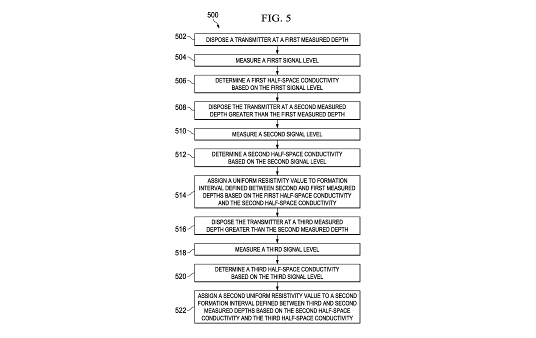
FIG. 5 is a flowchart showing an illustrative method for deriving a
resistivity log from
EM telemetry signal strength as a function of position. In the method 500, a
transmitter (e.g., a
gap subassembly of a BHA) is disposed at a first measured depth at block 502.
In this regard, a
voltage may be applied across the gap subassembly. At block 504, a first
signal level is measured
in response to the transmitter being at the first measured depth. For example,
an electric field
may be measured at an earth surface for the wellbore (e.g., along a particular
length of the earth
surface). At block 506, a first half-space conductivity is determined based on
the first signal
level. For example, a formation conductivity model may be applied in
determining the half-
space conductivity. The formation conductivity model may account for
parameters such as a size
of the gap subassembly, an outer diameter of a drill collar, and/or a
thickness of a wall of the
drill collar. At block 508, the transmitter is disposed at a second measured
depth that is greater
-12-
CA 03000149 2018-03-27
WO 2017/078708
PCT/US2015/059075
than the first measured depth. The second measured depth and the first
measured depth define a
formation interval there between. At block 510, a second signal level is
measured in response
to the transmitter being disposed at the second measured depth. At block 512,
a second half-
space conductivity is determined based on the second signal level. At block
514, a uniform
s resistivity value is assigned to the formation interval based on the
first half-space conductivity
and the second half-space conductivity.
At least blocks 508, 510, 512 and 514 in method 500 may be performed multiple
times
while during drilling of a borehole. For example, at block 516, the
transmitter is further
measured at a third measured depth that is greater than the second measured
depth. The third
fo measured depth and the second measured depth define a second formation
interval there
between. At block 518, a third signal level is measured in response to the
transmitter being at
the third measured depth. At block 520, a third half-space conductivity is
determined based on
the third signal level. At block 522, a second uniform resistivity value is
assigned to the second
formation interval based on the second half-space conductivity and the third
half-space
15 .. conductivity.
FIG. 6 is a graph 600 showing illustrative signal levels received during a
logging
scenario. In the logging scenario, a drill string is lowered in a borehole
such that a transmitter
(e.g., a gap subassembly of a BIIA 24 of FIG. 1) is positioned at various
measured depths in the
range of 0 to 3000 feet. As the transmitter is positioned at each of the
various depths, a level of
20 an EM telemetry signal received at the earth surface (e.g., a voltage Vr
of FIG. 3) is determined.
As illustrated in the graph of FIG. 6, the strength of the received signal
decreases as the measured
depth increases.
FIG. 7 is a graph 700 showing an illustrative resistivity profile. The profile
corresponds
to the logging scenario of FIG. 6. In the graph 700, points 702, 704,706
correspond to resistivity
25 values that are based on the levels of the EM telemetry signals received
at the earth surface. As
further illustrated in FIG. 7, the points 702, 704, 706 (which are based on EM
telemetry signals)
may be suitable approximation of points on a resistivity log that is generated
by a resistivity
logging tool (e.g., a tool that may involve a transmitter antenna and multiple
receiver antennas
located at different distances from the transmitter antenna along the axis of
the tool). If the
30 .. points 702, 704, 706 are determined based on EM telemetry signals and
these points are suitable
approximations, then it may not be necessary to use such a resistivity logging
tool in order to
provide an indication of the electrical resistivity of rock formations
surrounding an earth
borehole.
-13-
CA 03000149 2018-03-27
WO 2017/078708
PCT/US2015/059075
Various equations may involve using approximations. However, it is understood
that
these equations may be modified to account for additional factors. For
example, equations may
be modified to account for an impedance of the downhole transmitter unit (DTU)
(e.g., an
impedance of the gap subassembly of the BHA). As another example, in the
following inversion
s of signal level for half-space conductivity:
min, (23)
the minimization process of the above Equation (23) may be augmented with
regularization.
Various embodiments were described earlier with respect to a model based on
formation
intervals (e.g., intervals 302, 304) having a uniform half-space conductivity.
The model may be
modified to be based on formation intervals having a layered half-space
conductivity cr(z). Also,
the formation conductivity model may be frequency dependent (e.g., inclusive
of induced
polarization parameters) and/or anisotropic.
Processes and methods disclosed herein may be implemented as either stand-
alone
software, integrated as part of a commercial LWD data acquisition and
processing software (e.g.,
INSITE), or within well logging software. Methods disclosed herein may be
encapsulated in
software which may be programmed on serial and/or parallel processing
architectures. Methods
disclosed and related functions may be performed remotely from the well site
(e.g., on remote
servers or cloud computers), and computers located at the well site may be
connected to remote
processing computers via a network. Accordingly, computers located at the well
site may not
be required to provide a suitably high level of computational performance.
As disclosed earlier, resistivity determinations may be based on EM telemetry
signal
levels received by a surface receiver unit (SRU) (e.g., conductor 400) from a
downlink
transmitter unit (DTU) (e.g., BTA 24), or vice versa. Alternatively (or in
addition), the resistivity
determinations may be based on EM telemetry signal levels received by an SRU
from a
downhole repeater unit (DRU) (e.g., a repeater unit uphole from the DTU), or
vice versa.
Alternatively (or in addition), the resistivity determinations may be based on
EM telemetry
signal levels received by a DRU from a DTU, or vice versa. It is understood
that there may be
spatial overlap between DRU and DTU data, and transformation of such data may
be performed
transformed independently, cooperatively, or jointly.
Embodiments disclosed herein include:
A: A system that includes an electromagnetic logging tool that transmits an
-14-
CA 03000149 2018-03-27
WO 2017/078708
PCT/US2015/059075
electromagnetic signal as the tool is conveyed along a borehole through a
formation. The system
also includes a processing system that measures a first signal level in
response to the tool being
at a first measured depth, determines a first conductance based on the first
signal level, measures
a second signal level in response to the tool being at a second measured depth
greater than the
s first measured depth, the second measured depth and the first measured depth
defining a
formation interval there between, determines a second conductance based on the
second signal
level, and assigns a uniform resistivity value to the formation interval based
on the first
conductance and the second conductance.
B. A method that includes disposing a transmitter at a first measured depth,
measuring a
first signal level in response to the transmitter being at the first measured
depth, and determining
a first conductance based on the first signal level. The method also includes
disposing the
transmitter at a second measured depth greater than the first measured depth,
the second
measured depth and the first measured depth defining a formation interval
there between,
measuring a second signal level in response to the transmitter being at the
second measured
depth, determining a second conductance based on the second signal level, and
assigning a
uniform resistivity value to the formation interval based on the first
conductance and the second
conductance.
Each of the embodiments, A and B, may have one or more of the following
additional
elements in any combination. Element 1: wherein the processing system further
measures a third
signal level in response to the tool being at a third measured depth greater
than the second
measured depth, the third measured depth and the second measured depth
defining a second
formation interval there between, determines a third conductance based on the
third signal level,
and assigns a second uniform resistivity value to the second formation
interval based on the
second conductance and the third conductance. Element 2: wherein the tool
comprises a bottom
hole assembly comprising a gap subassembly. Element 3: wherein the tool
transmits the
electromagnetic signal in response to application of a voltage across the gap
subassembly.
Element 4: wherein the processing system measures the first signal level by
measuring an
electromagnetic field at an earth surface. Element 5: wherein the processing
system measures
the electromagnetic field at the earth surface by measuring the
electromagnetic field along a
particular length of the earth surface. Element 6: further comprising a
conductor extending
along the particular length of the earth surface, wherein the processing
system measures the
electromagnetic field along the particular length of the earth surface using
values of the
electromagnetic field sensed by the conductor. Element 7: wherein the
processing system
- 15 -
CA 03000149 2018-03-27
WO 20171078708
PCT/US2015/059075
determines the first conductance by applying a formation conductivity model.
Element 8:
wherein the tool comprises a bottom hole assembly comprising a gap subassembly
and a drill
collar, and the formation conductivity model accounts for at least a size of
the gap subassembly,
an outer diameter of the drill collar, or a thickness of a wall of the drill
collar. Element 9:
wherein the electromagnetic logging tool is a logging-while-drilling tool.
Element 10: further comprising disposing the transmitter at a third measured
depth
greater than the second measured depth, the third measured depth and the
second measured depth
defining a second formation interval there between, measuring a third signal
level in response to
the transmitter being at the third measured depth, determining a third
conductance based on the
third signal level, and assigning a second uniform resistivity value to the
second formation
interval based on the second conductance and the third conductance. Element
11: wherein the
transmitter comprises a gap subassembly of a bottom hole assembly. Element 12:
wherein
disposing the transmitter at the first measured depth comprises applying a
voltage across the gap
subassembly. Element 13: wherein measuring the first signal level comprises
measuring an
electromagnetic field at an earth surface for the wellbore. Element 14:
wherein measuring the
electromagnetic field at the earth surface comprises measuring the
electromagnetic field along a
particular length of the earth surface. Element 15: wherein determining the
first conductance
comprises applying a formation conductivity model. Element 16: wherein the
transmitter
comprises a gap subassembly of a bottom hole assembly, and the formation
conductivity model
accounts for at least a size of the gap subassembly, an outer diameter of a
drill collar, or a
thickness of a wall of the drill collar.
Numerous variations and modifications will become apparent to those skilled in
the art
once the above disclosure is fully appreciated. The methods and systems can be
used for
generating resistivity logs using telemetry data produced during drilling
operations. The ensuing
claims are intended to cover such variations where applicable.
- 16 -