Note: Descriptions are shown in the official language in which they were submitted.
= CA 03001771 2018-04-12
1
A METHOD FOR THE ALTERED PICTORIAL REPRESENTATION OF
POSITIONS OF THE LOCATIONS OF SELECTED DESTINATION
POINTS IN ELECTRONIC MAPS
The invention relates to a method for the electronically modified pictorial
represen-
tation of positions of locations of selected destination points in
geographical maps.
The representation to scale of distances of locations in maps, particularly in
road
maps, with other topographical conditions is known. Road maps are generally
used and comprehensible as information graphics. Road maps serve for the
visual
information about positions of locations. The contents are uniformly based on
a
map scale. Thus, the user of a road map is able to orient himself by means of
vari-
ous symbols and their arrangement on the road map in order to estimate and
plan
for distances and the route to a destination point.
Due to the uniformly applicable scale, the displayed symbols representing the
lo-
cation information are presented with the same ratio to the actual distance in
space. Classically, such road maps are distributed in a printed form and are
used
on monitors, as a visual display of the data in vehicular navigation systems,
route
planners or navigation systems on PCs or mobile devices. The IT-based usage
provides the user with the visual presentation of additional information, i.e.
primar-
ily the display of his location or starting point and the highlighting of
travel routes
and other traffic-specific, location-related information, such as traffic
obstructions,
refueling facilities and an estimated travel time for a selected or proposed
travel
route.
The representation of the location-related information in an information
graphic of
this type remains dependent upon the map scale. Therefore, the representation
of
the distances of locations remains tied to the map scale, and users estimates
the
position of the location and the travel time to arrive there based on the
representa-
tion, or he learns the travel time from spoken or visual additional
information. The
travel time has no influence on the visual representation of the location-
related in-
formation according to the map scale.
CA 03001771 2018-04-12
2
Travel times to other locations with the same distance in space may vary due
to
traffic routing, traffic situations, the choice of means of transport or other
condi-
tions. The display of the true-to-scale location distances may in that case be
mis-
leading with respect to the time expenditure necessary for covering the
distance.
For example, the travel duration for a route that is shorter in space may be
longer
in time than for a route that is longer in space, even though they are
displayed as
being closer or more distant in the true-to-scale display and the shorter
distance is
estimated to be more easily covered than the more distant location.
The travel times and other information, such as travel costs etc. are
generally pre-
sented only as retrievable additional information. Generally, alphanumerical
char-
acters are used for this purpose. An informative alteration of the map
representa-
tion based on visual perception, which depends on the additional information,
does
not take place.
The use of a conventionally true-to-scale map provides the user with no purely
vis-
ually represented information on the time or travel cost expenditure required
to
reach the locations indicated in the map and about which location distances
could
be reached with alternative means of transport with the same travel cost
expendi-
ture. Navigation systems, route planners and electronic maps are commercially
known which indicate routes to a selected destination point in a highlighted
man-
ner in accordance with certain criteria, such as the shortest travel time or
travel
distance, certain road types. Further information, such as travel costs, can
be dis-
played in accordance with the selected means of transport and the travel
destina-
tion. However, only as text-based additional information.
The visual presentation of information by means of road maps according to the
prior art is disadvantageous in that users are unable to immediately estimate
the
expenditure for reaching certain destination points from the starting point.
In the
visual map representation, the shortest distance between two locations is per-
ceived to be the travel distance that is the easiest to cover. In the event
users wish
to orientate themselves by referring to information other than proximity in
the map
representation, they need to refer to additional information, which slows down
the
presentation of information. For example, users most frequently have the
option,
CA 03001771 2018-04-12
=
3
when selecting the travel distance to a certain location, of selecting one of
three al-
ternative routes to the selected location. The alternative traffic routings
are then
displayed highlighted in color, and the travel times are displayed in a
legend. In
part, the costs for the journey or travel are also shown for this purpose if
the navi-
gation system or the route planner provides these data.
Commercially known maps based on a geographical scale thus only insufficiently
serve for advantageously and quickly absorbing relevant information, such as
travel time.
Other solutions are known in addition to the commercially known solutions for
in-
cluding the factor time in conventional geographical map depictions.
lsochronous map representations are known. Here, the time expenditure required
for reaching a destination is shown in different colors within a displayed
map. For
example, map regions that can be reached with the same time expenditure are
each provided with uniform coloring.
Though the representation of the factor travel time in an isochronous map com-
bines the geographical map with a time-based representation by the surfaces
and
points of the same time-based distance around a starting point being marked
with
an identical color, this type of representation cannot be directly absorbed by
hu-
man perception because the color-marked surfaces must first be identified, com-
pared and then assigned to the geographical representation in a search
process.
A representation of the travel time around a selected starting point is also
known
from DE 100 46 000 Al. Here, the representation dispenses with the
geographical,
conventional representation in favor of a purely time-dependent representation
of
the destinations around a selected starting point.
Thus, the representation of a purely time-based map as in DE 100 46 000 Al
only
serves insufficiently for incorporating the information of the factor travel
time
around a starting point in an improved manner. The assignment of the obtained
in-
formation in this purely time-based map lacks a geographical frame of
orientation.
CA 03001771 2018-04-12
4
Users are provided with a number of destination points on a white surface. The
ad-
vantage obtained is thus undone again, because the absorption of the
destination
points now requires a mental effort from the observer, namely, that he must
first
assign the destination points using further information, such as a
conventional ge-
ographical map.
From EP 1 56 60 Al, a representation of the factor travel time in an
electronic map
representation is also known, such that, subsequent to a starting and a
destination
location along the displayed route, the distinctive elements of the map, such
as the
representation of location and the road, are represented in a manner distorted
in
accordance with the factor time. EP 1 56 60 Al also mentions that the geograph-
ical representation of the route and the time-dependent representation of the
route
are shown simultaneously and in parallel in two windows on the screen in order
thus to enable a comparative absorption of the contents shown.
According to EP 1 56 60 Al, it is, however, disadvantageous that the
geographical
representation of the route and the time-dependent representation of the route
are
shown simultaneously and in parallel in two windows on the screen in order
thus to
enable a comparative absorption of the contents shown. However, the representa-
tion in two windows is an obstacle to a direct and uniform absorption. In
addition, it
has the large drawback that this form of display only works if the distortion
of the
time-based representation, compared to the conventional geographical represen-
tation, is only very slight. If, in the case of a passenger vehicle, the
possible travel
speeds of 20 - 200 km/h are taken into account, the time-based representation
of
a region comprising, as in the case of a major city, a motorway tangent, an
access
road and a traffic-reduced zone, for example, would be subject to such a great
dis-
tortion with the factor 10 that the time-based map no longer offers any
advanta-
geous informational usefulness.
In summary, all solutions according to the prior art are disadvantageous with
re-
spect to a significant improvement of the perception of the factor time and
other
additional information in a geographical map.
CA 03001771 2018-04-12
=
It is an object of the invention to improve the known methods and to indicate
a
method in which a user is able to directly discern the effort he requires to
reach
destination locations selected by him based on the starting point, in
particular,
which travel time he will need.
This object is achieved by means of the method according to claim 1.
According to the method, the location-based representation and the second
repre-
sentation, e.g. the time-based representation, are displayed on the screen
jointly
and one above the other. The destination location, which is represented by the
destination symbol, is identical in the location-based representation and the
sec-
ond representation. The goal is to represent in the second representation
those
destination locations that are more easily reached due to the selection
criterion,
e.g. the travel time, with destination symbols that are closer in the location-
based
representation to the starting symbol than the corresponding destination
symbols,
and those destination locations that require a greater expenditure farther
away
from the starting symbols than the associated destination symbols in the
location-
based representation. Preferably, the product of the distance, i.e. the travel
dis-
tance between the starting point and a destination location, times expenditure
(e.g.
travel time, costs, etc.) is to be optimized. Alternatively, only the
expenditure is
preferably to be minimized. In the location-based representation, the scale of
the
topographical map displayed on the screen is preferably constant and does not
change with the distance from the starting point.
By displaying the relationship between the position of at least one
destination sym-
bol in the location-based representation and the associated destination symbol
in
the second representation, the user is able to immediately recognize which
desti-
nation locations are more favorable, e.g. within reach within a certain time,
and
which are not. Therefore, so-called polar coordinates are advantageous for the
second representation. The destination symbol of the second representation ad-
vantageously is located on a straight line connecting the common starting
symbol
and the associated destination symbol in the location-based representation (of
the
same destination).
= CA 03001771 2018-04-12
6
In this case, it is advantageous that the starting point in the location-based
repre-
sentation matches the starting point in the second representation. Thus, users
need not re-orientate themselves. The second representation is incorporated
into
the location-based representation; users need not look at another
representation
and adapt to that.
A location-based representation is understood to be a representation as it can
be
found on a map and on GPS devices that are currently commercially available.
The location-based representation shows a section from a topographical map.
The
location-based representation is displayed with a linear scale.
Users directly obtain an information on how much expenditure is required to
reach
the destination location, superimposed on the location-based representation.
A data processing device is understood to be the electronic part of a GPS
device,
laptop, another computer or the like. The screen is connected to the data pro-
cessing device and controlled by it. For example, the screen is the screen of
a lap-
top or GPS device. The input unit is connected to the data processing device.
It is
configured as a keyboard, voice input device or touch-sensitive part of a
screen,
for example. The selection of the starting point, the selection of several
destination
locations, the setting of the selection criterion etc. are carried out by
means of the
input unit.
In an improved version, it is possible to reduce the brightness and/or the
infor-
mation content of one representation in relation to the other, so that the
overall
representation as a whole is easier to absorb. Thus, the informational content
of
the location-based representation may be reduced, for example. In particular,
this
can take place when the destination locations have been selected; then,
irrelevant
geographical data may be omitted.
The second representation is, in particular, a time-based representation.
Prefera-
bly, circles with different time intervals, e.g. 10, 20, 30 minutes, are shown
on the
screen around the destination symbol; this is to show that the destination
symbols
situated within these circles in the second representation can be reached
within
CA 03001771 2018-04-12
=
=
7
the specified time. Other representations are also possible as the second
repre-
sentation, e.g. travel costs, entry fees, traffic situation.
A connection between the two symbols of at least one individual pair of
symbols,
i.e. a destination symbol in the location-based representation and the
associated
destination symbol in the second representation, preferably of all pairs of
symbols,
is indicated. Thus, it is made possible for the user to easily recognize which
one of
the destination symbols of one representation belongs to a destination symbol
in
the other representation. The connection can be obtained by showing a connect-
ing line, in particular a straight line, between the symbols of a pair. Other
illustra-
tions of the connection are possible, e.g. different coloring, differing
symbols for
different pairs, etc.
The invention indicated in patent claim 1 is based on avoiding the delays in
the
presentation of location-based information in road maps when searching and se-
lecting destination locations and, in particular, to present the user of road
maps as
they are used for being displayed on monitors in IT technology with more infor-
mation relevant to decisions in a shorter amount of time for destination
selection.
This is based on the insight that human perception of the displayed contents
of a
map is limited. The possibilities of the perception of a human are limited by
his
physical conditions and determine the speed with which information can be ab-
sorbed, on the scale from an immediate absorption up to an absorption that, in
or-
der to be ensured, must be preceded by a series of cognitive processes.
For example, looking at an analog watch is a type of representation of time
whose
perception works directly and immediately for humans, provided that reading an
analog watch has been learned once. The immediate perception of the analog
time is aided by the closed optical system of the watch, in which the position
of the
watch hands also results in a directly perceptible image of the time. A
correspond-
ingly direct perception is intended with the invention in the area of map
searches.
If, as when looking at an analog watch, no further cognitive processes become
necessary for perception, or if they are limited to a minimum, absorption
takes
CA 03001771 2018-04-12
8
place quickly, intuitively and immediately. In all other cases, cognitive
processes
are first required for perception, which render understanding and perception
diffi-
cult and delay them. Examples for this include the cognitive efforts in
comparing
two types of maps in different scales or in reading, evaluating and combining
nu-
merical additional information added to the pictorial map representation.
The capacity of human perception, the speed and efficiency of absorbing visual
representations, are determined by a series of factors.
In the case of perceiving pictorial contents of a map, it is a decisive factor
whether
it is possible to perceive the map at a single glance or if sight must first
be guided
to two or more pictorial contents, or whether they also have to be processed
in a
cognitive process in order to absorb the message of the picture.
In the case of the perception of pictorial contents of a map, another decisive
factor
is how advantageously the contents shown are adapted to the template of gener-
ally known reference patterns of human perception.
Thus, the known, geographical world map with the display of the continents is
a
generally learned and internalized fundamental view that offers a universal
frame
of reference to humans. Human beings have also learned to become familiar with
the maps of their own countries and regions. This also includes general map
ele-
ments depicting both existing natural geographical elements, such as seas,
rivers
and woods, and man-made elements, such as borders, cities and roads. This
learned frame of reference forms the basis for physically absorbing the
contents of
a map and determines the speed with which individual elements of a map can be
absorbed.
If this geographical frame of reference is now abandoned by relinquishing the
gen-
eral geometric scale in favor of a, for example, purely time-dependent scale,
the
perception of the time-based map is unable to refer to any comparable, learned
el-
ements of the human mind. Creating a generally learnable time-based frame of
reference in the map representation like the one of the generally valid
geograph-
CA 03001771 2018-04-12
=
9
ical maps is not possible at all, because the time scale is always a relative
indica-
tion, which changes depending on the flexibly selected starting point and
other fac-
tors, such as the current traffic situation.
These insights from the psychology of perception are utilized for the solution
ac-
cording to the invention.
The advantages obtained with the invention in particular consist in enabling
the
user, using a map representation and based on certain criteria that can also
be
combined with each other, to obtain a pictorial representation of the
preferred de-
termination locations in the map, wherein a representation is used that
represents
the destination points in accordance with criteria other than those of
distance de-
pending on the starting point, instead or in addition to the true-to-scale
representa-
tion of the distances of the selected destination points from the starting
point.
Here, however, the map representation in accordance with the generally known
geographical scale is still, advantageously, not completely abandoned. Rather,
for
human absorption and perception, it functions as a frame of orientation and
refer-
ence for the change of position of the selected destinations taking place on
the ba-
sis of another scale, such as a time scale. Since two or more representations
are
thus taken into account in a single display, relevant information is visually
con-
densed around an individually selected starting point in a single section of
an im-
age or a map, and the information can thus be recognized and absorbed at a sin-
gle glance. A display of two or more representations in two or more separate
map
depictions is omitted. In its function as the frame of reference supporting
the ad-
vantageous perception at the moment of the change of position of selected
desti-
nations, the known geographical map can be reduced, image-wise, by selection
and reduction to, for example, few distinctive elements.
Thus, the destination points can be arranged in accordance with the preferred
cri-
teria, and the user can more easily compare the criteria of the destination
points
relevant to him. For the display of the time or cost expenditure for reaching
the in-
dicated destination points, the user need not refer to text-based indications,
but is
able to visually compare the expenditures for reaching the destination based
on a
CA 03001771 2018-04-12
positionally altered representation of the destinations or their symbols in
the dis-
play.
A representation different to the geometrical representation is additionally
used for
the selected destinations, and the destinations are additionally displayed in
ac-
cordance with at least one second representation without the geometrical scale
of
the rest of the map being altered. In the case of the selection criterion of
time, the
representation of the destination is the time required for reaching the
destination,
in the case of the selection criterion of travel costs, it is the travel costs
required for
reaching the destination.
Time and costs are two factors or selection criteria fundamentally inherent to
any
travel with a means of transport to a destination, and are thus of central
signifi-
cance for evaluating and selecting destinations. The choice of means of
transport
has a decisive influence on the form of the factors time and costs. Even if
one
does not use a conventional means of transport when traveling to a
destination,
but rather travels on foot without incurring costs, the latter may be assigned
a sum
of costs due to material wear or by incurring imputed opportunity costs.
In addition to the means of transport, however, other components are
significant
for searching the destination and reaching the destination, such as the route
to a
destination and the destination as such.
Thus, other representations may be displayed that are oriented towards
individual,
even subjective, attributes or selection criteria, provided they can be
transformed
into a numerical scale. For example, alternative destinations and also the
routes
may be perceived as having a different level of attractiveness. This
attractiveness
can be rated numerically and thus also function as a scale for the
representation of
reaching the destination.
The method according to the invention allows the user to obtain a selection of
dif-
ferent destination locations in accordance with the travel costs or travel
times or
other selection criteria for different means of transport or combinations
thereof
CA 03001771 2018-04-12
11
based on the visual representation, wherein the location distance is then
repre-
sented depending on the travel costs and/or travel times. In a possible
extended
variant, the attractiveness of the destination and/or of the route there is
also incor-
porated in a numerical form and combined in a uniform scale. In addition to
the re-
duced geographical map representation, the user is thus provided, superimposed
on this representation, with a single destination point representation in
accordance
with a uniformly scaled combination of various other representations, such as
time-based and/or cost-based representation and/or route attractiveness and/or
destination attractiveness (and/or other properties). Here, the user is able
to set
and individually weight the selection of the factors to be taken into account
in ac-
cordance with their individual user's preference.
Another advantageous embodiment of the invention consists of pictorially and
vis-
ually highlighting the properties of the destinations in accordance with their
advan-
tageousness. If, for example, the destinations are hotels, then their
advantageous-
ness is expressed, for example, by the price, the facilities, the
classification and
the reviews by hotel guests. These properties may be displayed with a single
sym-
bol, such as a circle, individually or in a combined manner or in a combined
and
weighted manner, wherein the circle expresses the destination and the diameter
of
the circle the advantageousness of the circle, wherein an increasing circle
diame-
ter expresses the increasing advantageousness of the destination. It is
another
embodiment of the invention that, when searching for different types of
destination,
such as hotels and sights and restaurants, each type of destination is
assigned its
own visual symbol in order to be able to distinguish the types of destination
from
one another at a glance. Since symbols of this type are generally known and
their
design in a changing size can be intuitively absorbed, this condensed visual
repre-
sentation serves for the quickest perception of the advantageousness of the
desti-
nation.
Another advantageous embodiment of the invention marks the advantageousness
of a route determined for reaching the destination by means of a symbolic,
picto-
rial, visual marking of this route. In this case, for example, the
attractiveness of
CA 03001771 2018-04-12
12
routes is incorporated in a numerical form and the routes are marked
correspond-
ingly, by marking them with an increasing intensity of the color or the line
as the
perceived attractiveness of the routes increase.
Thus, the method according to the invention enables the user to quickly and
effi-
ciently find, absorb and evaluate destinations, even if a multitude of
destinations
and parameters affecting the destinations is provided. In this case, a shift
of the
visual destination representation about a starting point into the center of
the image
of the display medium or screen is also advantageous. For example, the expendi-
ture for absorbing the actual time duration for reaching a destination in the
case of
hotels around a selected starting point is already very high if a high number
of
available hotels are provided. If the travel costs for reaching the individual
hotels
are taken into account at the same time, expenditure will continue to rise
signifi-
cantly. If further selection criteria involved in the stay at the hotel, such
as the hotel
price, the evaluation of the attractiveness of the hotel, the hotel facilities
are
added, however, the further expenditure does not rise linearly, but
disproportion-
ately to exponentially, and cannot be handled anymore from a certain point if
fur-
ther criteria are added. By condensing and visualizing the data in a single
map
section on a monitor in accordance with the method of the invention, however,
the
user is able to recognize and absorb the advantageousness of the selected
desti-
nation, in the exemplary case a hotel, at a single glance.
Exemplary embodiments of the invention that are not to be understood as
limiting
will be explained with reference to the drawings and described in more detail
be-
low. In this drawing:
Fig. 1 shows a representation of a topographical map on a screen, Munchen
stands for the city of Munic, Forstenrieder Park is a park area, and
Speichersee
stands for reservoir,
Fig. 2 shows the representation according to Figure 1, into which a starting
point
and several destination symbols for the destination locations have been
addition-
ally incorporated,
CA 03001771 2018-04-12
13
Fig. 3 shows a representation of just the starting point and the destination
symbols
from Fig. 2,
Fig. 4 shows the representation as in Figure 3 and additionally, in a time-
based
representation, the position of the destination symbols for the destination
locations
in the time-based representation, i.e. in accordance with their distance in
time from
the starting point; in this case, the two destination symbols of each
destination in
the differing representations are connected to one another by a straight line,
Fig. 5 shows the representation as in Figure 4; however, circles corresponding
to a
distance in time from the starting symbol are now additionally drawn around
the
starting symbol,
Fig. 6 shows a representation similar to Fig. 5, with altered destination
symbols,
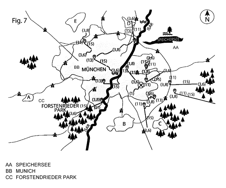
Fig. 7 shows the representation similar to Figure 1, superimposed on the repre-
sentation according to Figure 4,
Fig. 8 shows the representation according to Figure 5 before a representation
ac-
cording to Figure 1, which forms a pale background and which, in addition, is
re-
duced as regards the content of information,
Fig. 9 shows the representation according to Figure 4 before a representation
ac-
cording to Figure 1, which forms a pale background and which, in addition, is
re-
duced as regards its content of information, and
Fig. 10 shows a representation according to Figure before a representation ac-
cording to Figure 1, which forms a pale background and which, in addition, is
re-
duced as regards its content of information, and in which the selected
starting
point is located or centered in the center of the monitor.
For the positionally altered representation, the user first sets a starting
point 1. In
electronic maps 2, the representation is variable because the starting point 1
may
be changed or shifted at any time. It may correspond to the current location
or be
set in an arbitrary manner. In the case that the representation according to
the in-
CA 03001771 2018-04-12
14
vention is effected on a pre-printed map 2, typically required locations such
as ex-
hibition venues, airports, railway stations, public paces, tourist information
centers
etc. are selected for displaying the starting point 1, where the maps 2 with
the al-
tered representation of the destination locations 3 are then typically
distributed and
used in paper form.
All scale-based types of map qualify as maps 2, i.e. road maps, city maps,
hiking
maps, etc. Subsequent to determining a starting point 1 and its indication or
sym-
bol 4 on the map 2, the destination locations 3 to be displayed and the
expenditure
criteria 5 are determined.
Destination locations 3 to be displayed may be cities and towns, location-
based fa-
cilities such as hotels, restaurants, bars, shops, gas stations, museums,
sights,
playgrounds, utilities etc.
The travel time and the travel costs are particularly suitable as
specification of the
expenditure criteria or selection criteria 5. However, other criteria 5, such
as traffic
density, attractiveness of the travel route, attractiveness of the destination
etc.
may also qualify individually or combined.
Then, the destination locations 3 are displayed in a true-to-scale
representation
variant 6 on the map 2 by means of highlighting or destination symbols (in the
1st
representation) 7. By selecting a second altered representation 8, the
positions of
the displayed and highlighted destination locations 3 in relation to the
selected ex-
penditure criteria 5 are displayed by a second highlighting or destination
symbol
(in the 2nd representation) 9. For this purpose, the destination locations 3,
in rela-
tion to the expenditure criterion 5, are shown on a straight line 10 to the
starting
point 1 either closer 11 to, at the same position 11 or farther away 12 from
the
starting point 1. Destination locations 3 that can be reached with a lower
expendi-
ture than the expenditure corresponding to their true-to-scale position 6 in
the lo-
cation-based representation are correspondingly displayed closer to the
starting
point 1. Destination locations 3 that can be reached with a greater
expenditure are
accordingly represented farther away. The distance for the altered
representation
8 of the destination location 3 is determined in relation to the selected
expenditure
CA 03001771 2018-04-12
criterion 5 or by a combination of several expenditure criteria 5. For better
orienta-
tion, the distances thus determined are assigned interval steps, so that they
can
be displayed on the map 2 by means of concentric circular lines 13, with the
start-
ing point 1 simultaneously indicating the position of the center of the
circle.
In order to present the information concerning the specific expenditure
regarding
individual destination locations 3, the altered positions of the locations 8
are dis-
played within the assigned circular intervals 14. In this case, it is
advantageous to
represent the change of position by means of a connecting line 15 between the
true-to-scale position of the location 6 and the expenditure-based position of
the
location 8, wherein the approach to the starting point 1 and the distancing
from the
starting point are made intuitively recognizable. For this propose, the
connecting
line 15 may be continuous or dashed or color-coded, have arrow symbols indicat-
ing the direction of change, or have another significant form of
representation. The
original true-to-scale positions of the location 6 may also be represented in
a
transparent form or with a different color. For determining the expenditure,
the
method preferably takes into account all available information concerning
traffic
conditions, in particular the current traffic situation, weather conditions
and other
conditions that may affect the selected expenditure criterion 5. While the
destina-
tion locations 3 arrange themselves based on the expenditure, the geographical
true-to-scale map representation 16 visually recedes into the background, for
ex-
ample by means of a limitation to a few distinct geographical orientation
elements
17, or by means of a further pictorial and visual reduction.
According to an advantageous embodiment, the change of position of the destina-
tion locations 3 subsequent to the selection of the expenditure criterion 5
takes
place dynamically, so that the change of position of the destination locations
3, ac-
cording to the geometrical scale 6 relative to their altered position, takes
place as
a movement, which is represented on the screen and thus enables the observer
to
absorb more quickly and effectively the advantageousness of a destination loca-
tion 3 that was, for example, previously not taken into account. The observer
views
a short video or another graphical, electronic, visual animation with a
duration of,
CA 03001771 2018-04-12
16
for example, 1 minute at most, if need be 3 minutes at most. Then, he will see
the
display as in Figure 7.
According to an advantageous further embodiment, a selection of the available
means of travel and transport may take place subsequent to the determination
of
the starting point 1. The individual selection of the transport means then
forms the
basis of the calculation of travel costs for the expenditure criterion 5 of
travel costs.
The selection may be limited to a single means of transport, such as a
passenger
vehicle, or a combination of different means of transport, such as an
airplane, rail-
way, public transport, taxi, bicycle, pedestrian etc. In this case, the
combination of
the means of transport can advantageously be adapted in accordance with an op-
timization of the travel costs. The combination of the means of transport is
calcu-
lated and displayed such that the result is the cheapest total price.
According to another advantageous embodiment, the positionally altered destina-
tion locations are indicated with symbols 1, wherein the size of the
individual sym-
bol 1 takes into account an advantageousness of the destination locations 3.
Dif-
ferent types of destination locations 3 may be labeled with respectively
uniform
symbols 1.
According to another advantageous embodiment, individual opportunity costs may
also be included as an expenditure criterion 5 in addition to taking into
account the
travel costs of different means of transport. For example, the travel time to
a desti-
nation defines a time that cannot be used otherwise, and is thus taken into ac-
count by means of an individual sum of costs incorporated into the calculation
of
the total travel costs related to the travel destination.
Another advantageous embodiment enables the positionally altered
representation
of the destination locations 3 in accordance with an expenditure criterion 5
ex-
panded by the user by further expenditure criteria 5 and other components
affect-
ing the destination. Thus, the component of the time-dependent representation
of
the destination can be taken into account in addition to the representation of
the
destination based on the travel costs. In one variant, the selected
destination loca-
tions 3 are displayed in a positionally altered manner in accordance with the
travel
CA 03001771 2018-04-12
17
costs, and in another selectable variant, the destination locations 3 are
displayed
in a positionally altered manner in accordance with the criterion 5 of time
expendi-
ture. For another variant, the user may weight the individual expenditure
criteria 5
equally or differently for their combination and thus generate a variant of
the posi-
tionally altered destination locations 3 in accordance with the combined
expendi-
ture criteria 5 in a single representation.
According to another embodiment of the invention, the positionally altered
display
of the destination locations includes a selection of different types of
destination lo-
cations 3 and their individual combination, and also the exclusion of
individual des-
tination locations 3.
For an improved intuitive perception, another embodiment of the invention pro-
vides that the user is enabled to change the position of the starting point 1
and the
displayed destination locations 3 including the map 2. Depending on the
individual
preference, the starting point 1 can be displayed in the center or another
location
on the screen.
The true-to-scale map 2 shown in Fig. 1 shows the distances between various
cit-
ies, the position of rivers and lakes, the size of a city and the course and
geo-
graphical position of the roads as geographical orientation elements 17 to
scale.
The map 2 in Fig. 1 corresponds to a conventional true-to-scale map 2 that can
be
read and understood by anybody. The positions of the location are shown to
scale.
The known kilometer values, converted into a scale, apply. The typical
elements of
a map 2 are represented by symbols which, depending on the type of map, are ex-
plained in an additional legend, but whose depiction was omitted here. Anybody
is
capable of reading the map and deriving from it that the distances of the
locations
in space from one another are different, and via which road they could arrive
at
certain locations.
Fig. 2 shows the true-to-scale highlighting 7 of destination locations 3 in
map 2.
Fig. 2 shows the same map 2 as Fig. 1. The representation is supplemented with
a
display of the possible destination locations 3 and the display of the
starting point
CA 03001771 2018-04-12
18
1. The destination locations 3 may be individually selected according to
certain cri-
teria, such as locations, sights, hotels, restaurants, etc. They are
electronically dis-
played by means of highlighting 7, and are represented by a drop-shaped symbol
in Fig. 2. Their representation in the map corresponds to their actual
position in
space 12 just as the position of the starting point 1.
Fig. 3 shows the true-to-scale highlighting 7 of destination locations 3
without the
map 2. Fig. 3 shows the unaltered position of the destination locations and
their
highlighting 3, 7 and the starting point 1 dissociated from the representation
of
map 2. The arrangement of the destination locations 3 is not self-explanatory
to
the observer from this representation. Only an orientation based on the
geograph-
ical orientation elements 17, as they are typically shown in map 2, would
provide
any support. The observer, based on the distances between the starting point 1
and the destination location 3, could draw conclusions with regard to the
distance
that appears different to that from the other destination locations 3.
However, this
would require a particular interpretation of the representation.
Fig. 4 shows the altered destination locations 8 without a map 2. In Fig. 4,
the rep-
resentation of the destination locations 3, 6 and of the starting point 1 as
in Fig. 3
is used to show the change of position of the destination locations 3
calculated
from the expenditure criterion 5. Destination locations 3 that, according to
the se-
lected expenditure criterion 5, have a more favorable position relative to the
start-
ing point 1 are depicted closer 11 to the starting point 1. Destination
locations 3
whose position must be rated less favorably according to the selected
expenditure
criterion 5 are depicted to be more distant 13. The distance of the altered
position
to the original position 6 is marked by a shift line 15.
Fig. 5 shows the altered destination locations 8 with circular lines 14
without the
map 2. Fig. 5 shows everything as described with respect to Fig. 4. The
represen-
tation is supplemented by the circular lines 14, which facilitates the
assignment of
one or more destination locations 3 to a certain interval step between the
circular
lines 14.
CA 03001771 2018-04-12
19
Fig. 6 shows the altered destinations with symbols 1. Fig. 6 shows the
positionally
altered representation of the destination locations. Various symbols 1
identifying
the quality and type of destination location 3 are used for highlighting the
position-
ally altered destination locations 3, 9.
Fig. 7 shows the altered destination locations 8 with the map 2. Finally, Fig.
7 illus-
trates a positionally altered representation of the destination location 3, 9
with the
shift lines 15 as described with respect to Fig. 4. The representation of the
destina-
tion locations 3 used in Fig. 4 is superimposed on a map 2 according to Fig. 1
as
background, so that the true-to-scale position 6 of the destination locations
3 can
be located exactly on the map. The more advantageous destination locations are
shifted in the direction of the starting point 1 and, from the logic of the
map, can be
identified to be closer or more advantageous, whereas the more distant destina-
tion locations 3, 13 are understood to be distant and less advantageous.
Fig. 8 shows the map 2 as a background with reduced image information. Fig. is
a
display of the map 2 according to Fig. 1 as it is used, reduced for visual
percep-
tion, as a background. The number of geographical orientation elements 17 is
re-
duced, and the image is brightened up for presentation. The altered position
of the
destination locations 3 and their geographical 3, 6 position with a display of
the
connecting lines 15 as in Fig. 5 is superimposed thereon.
Fig. 9 corresponds to Fig. 8 with destination locations 3, 8 and circular
lines 14.
Similar to Fig., Fig. 9 is a display of the map 2 according to Fig. 1 used,
reduced
for visual perception, as a background. The number of geographical orientation
el-
ements 17 is reduced, and the image is brightened up for presentation. The al-
tered position of the destination locations 3 and a representation of the
circular
lines 14 is superimposed thereon.
Fig. 10 shows the map 2 with the destination locations 3, 8 around a centered
starting point 1. Fig. 10 shows Fig., supplemented by the method step of a cen-
tered representation of the starting point 1.
=
= CA 03001771 2018-04-12
In the method for a variable display of certain destination locations 3 in a
topo-
graphical map 2, the starting point 1 is selected or specified; the latter is
shown in
the map 2 in a highlighted manner. Preferably, it is displayed in a centered
manner
on the map 2. In accordance with a specification for the destination locations
3 to
be displayed, those positions of the locations matching the destination
specifica-
tions 6 are also highlighted 7 in the map section used. For the selection of a
dis-
play of the destination locations 3 in a different map scale to that of the
spatial
map section, expenditure criteria 5 are selected and, based on information
rele-
vant to the location, used as a basis for the altered scale. The altered
position of
the displayed destination locations 3 determined therefrom is then pictorially
repre-
sented in accordance with the selected starting point 1 without the
geometrical
scale of the map 2 being altered in any other way. For representing the
altered po-
sition in the map 2, the map 2 is preferably brightened, displayed in a
blurrier man-
ner, reduced and/or otherwise reduced in informational content. Due to the
first ini-
tial map being reduced as regards graphics and content, in particular if it is
super-
imposed on the time-based representation, less of a burden is placed on the
user.
By combining the two maps and the following animation, selection, reduction
and
finally centering of the two maps, a content is obtained that is easily
absorbed.
' CA 03001771 2018-04-12
21
List of Reference Numerals
1 Starting point
2 Map
3 Destination locations
4 Display of starting point, symbol for starting point
Expenditure criteria/criterion
6 True-to-scale position of destination location
7 True-to-scale highlighting of destination location or
destination symbols (in
1st representation)
8 Altered position of destination location
9 Highlighting of destination location or destination symbols
(in 2st represen-
tation) based on criteria
Straight line to starting point
11 Destination location closer to starting point than in
location-based repre-
sentation
12 Unaltered position of destination location
13 Destination location more distant from starting point than in
location-based
representation
14 Circular lines
Shift line
16 True-to-scale map representation
17 Geographical orientation element
18 Symbols