Note: Descriptions are shown in the official language in which they were submitted.
84259532
SURVEYING USING AN UNMANNED MARINE SURFACE VESSEL
[0001]
Background
[0002] A survey data acquisition system can be used to acquire survey data
of a
target structure, such as a subsurface structure underneath an earth surface.
The
survey data acquisition system can include one or more survey sources and
survey
sensors. The one or more survey sources can generate survey signals that are
directed
into the target structure. Signals that are reflected from or otherwise
affected by the
target structure can be detected by the survey sensors, which can output
measured
survey data.
[0003] The measured survey data can be transmitted to a computer system
for
recording and analysis. The computer system can then process the measured
survey
data to characterize the target structure, such as by producing an image of
the target
structure, producing a model of the target structure, or producing other data
that
provides a representation of one or more parameters relating to the target
structure.
Summary Of The Invention
[0004] According to an aspect of the present disclosure, there is
provided a method
of marine surveying, comprising: deploying an unmanned marine surface vessel
connected to a three-dimensional array of sensors positioned in a proximity of
an
obstruction area of a survey environment, the three-dimensional array of
sensors
comprising a plurality of rigid elongated supports, wherein a plurality of
sensors of the
three-dimensional array of sensors are mounted on a respective rigid elongated
support
of the plurality of rigid elongated supports, and the plurality of sensors of
the three-
dimensional array of sensors is spaced apart from another in three dimensions,
and
wherein a portion of the plurality of rigid elongated supports are
substantially parallel to
one another; and recording, by the three-dimensional array of sensors
positioned in the
proximity of the obstruction area of the survey environment, a plurality of
signals that is
affected by a target structure, wherein the plurality of signals is recorded
by the three-
dimensional array of sensors deployed on an opposite side of a survey source
with
respect to the obstruction area, and wherein only the plurality of signals is
used to infill
1
Date Recue/Date Received 2023-03-23
84259532
holes in recorded data by an additional plurality of sensors on a marine
streamer that is
unable to be deployed in the obstruction area.
[0004a] According to another aspect of the present disclosure, there is
provided a
survey acquisition system comprising: an unmanned marine surface vessel; a
three-
dimensional array of sensors connected to the unmanned marine surface vessel
and
positioned in a proximity of an obstruction area of a survey environment, the
three-
dimensional array of sensors comprising a plurality of rigid elongated
supports, wherein
a plurality of sensors of the three-dimensional array of sensors is mounted on
a
respective rigid elongated support of the plurality of rigid elongated
supports, and the
plurality of sensors of the three-dimensional array of sensors is spaced apart
from
another in three dimensions, and wherein a portion of the plurality of rigid
elongated
supports is substantially parallel to one another, and an additional portion
of the plurality
of rigid elongated supports is substantially perpendicular to one another, the
three-
dimensional array of sensors positioned in the proximity of the obstruction
area of the
survey environment to record a plurality of signals that is affected by a
target structure,
wherein the plurality of signals is recorded by the three-dimensional array of
sensors
deployed on an opposite side of a survey source with respect to the
obstruction area,
and wherein only the plurality of signals is used to infill holes in recorded
data by an
additional plurality of sensors on a marine streamer that is unable to be
deployed in the
obstruction area.
[0004b] According to another aspect of the present disclosure, there is
provided an
unmanned survey acquisition device comprising: a wave powered glider that is
moveable using power derived from waves of a water surface; a three-
dimensional
array of sensors positioned in a proximity of an obstruction area of a survey
environment and configured to acquire a plurality of signals that is affected
by a target
structure underneath the obstruction area, wherein the plurality of signals is
recorded by
the three-dimensional array of sensors deployed on an opposite side of a
survey source
with respect to the obstruction area, and wherein only the plurality of
signals is used to
infill holes in recorded data by an additional plurality of sensors on a
marine streamer
that is unable to be deployed in the obstruction area, the three-dimensional
array of
sensors comprising a plurality of rigid elongated supports, wherein a
plurality of sensors
of the three-dimensional array of sensors is mounted on a respective rigid
elongated
1a
Date Recue/Date Received 2023-03-23
84259532
support of the plurality of rigid elongated supports, and the plurality of
sensors of the
three-dimensional array of sensors are spaced apart from another in three
dimensions,
and wherein a portion of the plurality of rigid elongated supports is
substantially parallel
to one another, and an additional portion of the plurality of rigid elongated
supports is
substantially perpendicular to one another; and a tow line to connect the wave
powered
glider and the three-dimensional array of sensors.
Brief Description Of The Drawings
[0005] Some implementations of the present disclosure are described with
respect
to the following figures.
[0005a] Fig. 1 is a schematic diagram of an example arrangement that includes
an
example unmanned survey acquisition device according to some implementations.
[0006] Fig. 2 is a block diagram of components in an unmanned marine
surface
vessel according to some implementations.
[0007] Figs. 3A-3B and 4-7 are schematic diagrams of different example
marine
survey arrangements that include unmanned survey acquisition devices according
to
some implementations.
lb
Date Recue/Date Received 2023-03-23
CA 03002155 2018-04-16
WO 2017/066028
PCT/US2016/055235
[0008] Fig. 8 is a flow diagram of an example process for acquiring
survey data,
according to some implementations.
Detailed Description
[0009] Reference will now be made in detail to some implementations,
examples of
which are illustrated in the accompanying drawings and figures. In the
following
description, numerous specific details are set forth in order to provide a
thorough
understanding of some example implementations. However, it will be apparent to
one
of ordinary skill in the art that the implementations may be practiced without
these
specific details.
[0010] It will also be understood that the terms first, second, etc., are
used to
distinguish one element from another, and does not specify any order of
elements or
tasks. As used in the description and the appended claims, the singular forms
"a," "an"
and "the" are intended to include the plural forms as well, unless the context
clearly
indicates otherwise. It will also be understood that the term "and/or" as used
herein
.. refers to and encompasses any possible combinations of one or more of the
associated
listed items. It will be further understood that the terms "includes,"
"including,"
"comprises" and/or "comprising," when used in this specification, specify the
presence
of stated features, integers, operations, elements, and/or components, but do
not
preclude the presence or addition of one or more other features, integers,
operations,
.. elements, components, and/or groups thereof.
[0011] As used herein, the term "if" may be construed to mean "when"
or "upon" or
"in response to determining" or "in response to detecting," depending on the
context.
Similarly, the phrase "if it is determined" or "if [a stated condition or
event] is detected"
may be construed to mean "upon determining" or "in response to determining" or
"upon
detecting [the stated condition or event]" or "in response to detecting [the
stated
condition or event]," depending on the context.
[0012] In some examples, a survey data acquisition system can include
a seismic
data acquisition system, which includes a seismic source (or multiple seismic
sources)
and a seismic sensor (or multiple seismic sensors). In other examples, a
survey data
acquisition system can include an electromagnetic (EM) data acquisition
system, which
includes an EM source (or multiple EM sources), and an EM sensor (or multiple
EM
sensors).
2
CA 03002155 2018-04-16
WO 2017/066028
PCT/US2016/055235
[0013] More generally, a survey data acquisition system can include a
survey
source (or multiple survey sources) and a survey sensor (or multiple sensors),
where a
sensor can acquire survey data of a target structure in response to signals
emitted by
the survey source(s). In some examples, the target structure can include a
subsurface
structure that is underneath an earth surface.
[0014] Although reference is made to surveying subsurface structures
in the
disclosure, it is contemplated that techniques or mechanisms according to some
implementations can be applied to surveying of other types of target
structures, such as
mechanical structures, mammals, fish, or other structures.
[0015] In a marine acquisition system, survey source(s) and survey
sensor(s) can
be towed through a body of water. In some examples, survey sensors can be
arranged
on a marine streamer (or more simply "streamer") or multiple streamers. A
streamer
can be towed by a manned marine surface vessel. A manned marine surface vessel
can refer to a marine surface vessel that is driven by a human located on the
marine
surface vessel. A marine surface vessel can refer to a vessel that is to be
deployed on
the top surface of a body of water, such as the sea surface. A manned marine
surface
vessel can tow one or more streamers. In some cases, multiple manned marine
surface vessels can two multiple streamers.
[0016] A marine environment can include various obstructions, such as
marine
platforms (where surface well equipment can be deployed to produce or inject
fluids in a
subsea well), marine surface facilities (to store or process fluids), natural
formations, or
any other designated region that may be sensitive to presence of equipment of
a marine
acquisition system.
[0017] An area of a survey environment that includes one or more
obstructions can
be referred to as an "obstruction area." An exclusion zone can be defined
around the
obstruction area, where the exclusion zone can have a larger area than the
obstruction
area. An exclusion zone is a zone in a survey environment where towed
streamers
towed by manned marine surface vessels are not allowed to enter (in other
words,
streamers are excluded from the exclusion zone). The exclusion of streamers is
to
avoid possible damage of certain structures (such as marine platforms, marine
surface
facilities, natural formations, etc.) due to collisions with the streamers. In
other
3
CA 03002155 2018-04-16
WO 2017/066028
PCT/US2016/055235
examples, there can be other reasons to exclude streamers (or other equipment
of
marine acquisition systems) from exclusion zones.
[0018] Because streamers cannot be towed through an exclusion zone
during a
survey acquisition operation, holes can be created in the coverage of the
subsurface
structure by measured survey data, due to the inability to acquire survey data
using
sensors deployed in the exclusion zone. In some cases, the exclusion zone can
be
located above a subsurface structure of interest, and holes that are created
in the
coverage of the measured survey data can lead to inaccurate characterizations
of the
subsurface structure based on the processing of the recorded survey data.
[0019] In some cases, additional shorter streamers can be deployed using an
extra
manned marine subsurface vessel, in an attempt to undershoot the obstruction
area.
Undershooting an obstruction area can refer to projecting survey data into the
obstruction area using a streamer that is deployed outside the obstruction
area.
However, the shorter streamers have different designs from regular streamers,
and
using streamers of different designs to perform survey acquisition operations
can be
expensive because the streamer spread has to be reconfigured to have streamers
of
different designs.
[0020] In accordance with some implementations of the present
disclosure,
unmanned survey acquisition devices can be employed to acquire survey data in
a
.. survey environment that has an obstruction area. The unmanned survey
acquisition
device is allowed to enter the obstruction area or to be positioned close to
the
obstruction area (such as within an exclusion zone but outside the obstruction
area).
More generally, the unmanned survey acquisition device is able to be
positioned closer
to an obstruction area to acquire survey data than can a streamer.
[0021] An unmanned survey acquisition device includes sensors (e.g.,
seismic
sensors and/or EM sensors) that can be used to record signals affected by a
target
structure, such as a subsurface structure. An unmanned survey acquisition
device
includes an unmanned marine surface vessel and an array of sensors (also
referred to
as a "sensor array") that is connected to the unmanned marine surface vessel.
An
unmanned marine surface vessel is a marine surface vessel that is not driven
by a
human that is located on the marine surface vessel. Rather, the unmanned
marine
surface vessel can be an autonomous marine surface vessel that is able to
guide itself
4
CA 03002155 2018-04-16
WO 2017/066028
PCT/US2016/055235
through a body of water, and/or that can be controlled remotely by a human
that is
located away from the marine surface vessel.
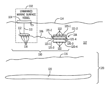
[0022] Fig. 1 is a schematic diagram showing an example of an unmanned
survey
acquisition device 100. The unmanned survey acquisition device 100 includes an
unmanned marine surface vessel 102 and an array of sensors 104 (also referred
to as a
"sensor array) that is connected to the unmanned marine surface vessel over a
tow
cable 106. The unmanned marine surface vessel 102 tows the sensor array 104
through a body of water 107. The tow cable 106 can include communications
lines to
allow survey data acquired by sensors of the sensor array 104 to be
communicated to
the unmanned survey surface vessel 102.
[0023] In some examples, the tow cable 106 can be a motion-isolation
tow cable.
The motion-isolation tow cable 106 allows the sensor array 104 to remain
stationary
even though there is some small amount of motion of a stopped unmanned marine
surface vessel 102.
[0024] The sensor array 104 can include a three-dimensional (3D) array of
sensors.
A 3D array of sensors is able to acquire survey data in 3D space. As shown in
Fig. 1,
the 3D array of sensors 104 includes multiple sensor supports 120-1, 120-2,
120-3, and
120-4. Each sensor support 120-i (i = 1 to 4) is generally a rigid elongated
support,
such as in the form of a rod in some examples. The rigid elongated supports
can be
formed of a rigid material, such as metal or other rigid material. Multiple
sensors 122
can be mounted on each sensor support 120-i and can be spaced apart from one
another along the length of the sensor support 120-i. In some examples,
multiple
sensor supports 120-i are arranged to be substantially parallel to one
another, such as
parallel along a horizontal axis or some other axis. Sensor supports are
substantially
parallel to one another if the sensor supports are parallel to within
manufacturing or
assembly tolerances of the sensor array 104, such as to within 10 of one
another. The
sensors 122 of the 3D array are spaced apart from another in three dimensions.
[0025] The sensor array 104 further includes additional rigid
elongated supports
121-1, 121-2, 121-3, and 121-4 that interconnect respective pairs of the
sensor supports
120-1, 120-2, 120-3, and 120-4. Each rigid elongated support 121-1, 121-2, 121-
3, or
121-4 is substantially perpendicular to each rigid elongated support 120-i.
Rigid
elongated supports are substantially perpendicular to one another if the
sensor supports
5
CA 03002155 2018-04-16
WO 2017/066028
PCT/US2016/055235
are perpendicular to within manufacturing or assembly tolerances of the sensor
array
104, such as to within 80 -100 of one another. Although not shown, one or
more
sensors 122 can also be mounted on each of one or more of the rigid elongated
support
121-1, 121-2, 121-3, and 121-4.
[0026] Although a specific number of sensor supports 120-1 to 120-4 and 121-
1 to
121-4 are shown in Fig. 1, it is noted that in other examples, a different
number of
sensor supports can be used.
[0027] In examples according to Fig. 1, the unmanned marine surface
vessel 102
includes a glider float 108 that floats on a water surface 114 (e.g., sea
surface or more
generally the top surface of the body of water 107). The glider float 108 is
connected by
an umbilical structure 110 to a glider sub 112. The umbilical structure 110
mechanically
couples the glider float 108 to the glider sub 112. Although the glider float
108 floats on
the water surface 114, the glider sub 112 is positioned underneath the water
surface
114. Additionally, communications lines can be run through the umbilical
structure 110
to allow for communications between electronic components in the glider sub
112 and
electronic components in the glider float 108.
[0028] In some examples, the glider float 108 is a wave glider float
that is wave
powered. The wave-powered glider float 108 is propelled by wave motion, i.e.,
the
motion of the waves on the water surface 114. Wave motion is greater at the
water
surface 114, and decreases with increasing depth underneath the water surface
114. A
rising wave lifts the glider float 108, causing the tethered (as attached by
the umbilical
structure 110) glider sub 112 to rise. Articulated wings 116 on the glider sub
112 are
pressed down, and the upward motion of the glider sub 116 becomes an up-and-
forward motion, which in turn pulls the glider float 108 forward and off a
wave at the
water surface 114. This in turn causes the glider sub 112 to drop, and the
wings 112 to
pivot upwardly, thereby causing the glider sub 112 to move down and forward.
[0029] Although reference is made to an unmanned marine surface vessel
that is
wave powered in some examples, it is noted that in other examples, the
unmanned
marine surface vessel can include a different type of propulsion mechanism to
move the
unmanned marine surface vessel 102 across the water surface 114. The different
type
of propulsion mechanism can include a propeller or other type of propulsion
mechanism
to cause forward motion of the unmanned marine surface vessel 102.
6
CA 03002155 2018-04-16
WO 2017/066028
PCT/US2016/055235
[0030] Fig. 1 also shows a water bottom surface 118, such as a sea
bottom or sea
bed. Underneath the water bottom surface 118 is a subsurface structure 120,
which
can include one or more subsurface elements 122 of interest, such as
hydrocarbon
reservoirs, water aquifers, specific geological formations, or any other
structures.
[0031] Fig. 2 is a block diagram of components in the unmanned marine
surface
vessel 102 according to some examples. More specifically, in examples where
the
unmanned marine surface vessel 102 includes the glider float 108 and the
glider sub
112, the components shown in Fig. 2 can be part of the glider float 108.
[0032] The unmanned marine surface vessel 102 can include a power
source (or
multiple power sources). In examples according to Fig. 2, the power sources
include a
solar panel 202 and a battery 204. The solar panel 202 is used to convert
solar energy
into electrical power, which can be used to charge the battery 204 and to
power other
electronic components in the unmanned marine surface vessel 102. In other
examples,
different types of power sources can be used. Instead of a solar panel or a
battery, a
power source can instead be an engine that converts petroleum into power, or
another
type of power source.
[0033] The unmanned marine surface vessel 102 further includes a
Global
Positioning System (GPS) receiver 206, which is used to acquire GPS signals to
use in
determining a position of the unmanned marine surface vessel 102, and also to
acquire
timing information for synchronizing a clock of the unmanned marine surface
vessel
102.
[0034] The unmanned marine surface vessel 102 can also include a
communications interface 208, to allow for communications with a remote
system, and
also to the sensor array 104. In some examples, the communications interface
208 can
include a wireless communications interface to perform wireless
communications. For
example, the communications interface 208 can be used to communicate with a
satellite. In other examples, the communications interface 208 can include a
radio
frequency (RF) interface to perform RF communications.
[0035] The unmanned marine surface vessel 102 further includes a
vehicle
management computer 210 that is able to control motion of the unmanned marine
surface vessel 102. The vehicle management computer 210 can control a path
taken
7
CA 03002155 2018-04-16
WO 2017/066028
PCT/US2016/055235
by the unmanned marine surface vessel 102 using any or some combination of the
following: information from the GPS receiver 206, route information (which
specifies a
route to be taken by the unmanned marine surface vessel 102) programmed into
the
vehicle management computer 210, and/or control signals received from a remote
source through the communications interface 208.
[0036] The unmanned marine surface vessel 102 further includes a
storage medium
212 to store data, such as survey data acquired by sensors of the sensor array
104 and
transmitted to the unmanned marine surface vessel 102.
[0037] The unmanned marine surface vessel 102 is part of a mini-
acquisition
system in which the storage medium 212 can be used to store survey data. In
further
examples, the unmanned marine surface vessel 102 can include a real-time
quality
control (QC) capability.
[0038] Fig. 3A is a top schematic view of a marine survey arrangement
according to
some examples. Fig. 3A shows an obstruction area 302 that can include one or
more
obstructions. Fig. 3A also shows an array 308 of unmanned survey acquisition
devices
100 (generally in a grid pattern) deployed on a first side 304-1 of the
obstruction area
302. Fig. 3A also shows streamers 306 deployed on a second side 304-2 of the
obstruction area 302, where the second side 304-2 is opposite of the first
side 304-1.
The streamers 306-1 and 306-2 are towed by one or more manned marine surface
vessels (not shown) along respective sail lines 307-1 and 307-2. A sail line
indicates a
direction of movement of a respective streamer.
[0039] Each streamer 306-1 or 306-2 includes survey sensors (indicated
by circles)
and survey source(s) (indicated by diamonds). Although Fig. 3A shows an
example
where a survey source and survey sensors are arranged on the same streamer, it
is
noted that in other examples, the survey source and survey sensors can be
mounted on
separate structures.
[0040] Although a specific number of streamers 306-1 and 306-2 are
shown in Fig.
3A, it is noted that in other examples, a different number of streamers can be
employed
(e.g., one streamer or more than two streamers). Similarly, in other examples,
a
different number of unmanned survey acquisition devices 100 can be employed.
8
CA 03002155 2018-04-16
WO 2017/066028
PCT/US2016/055235
[0041] During operation, the survey source(s) can be activated (such
as in response
to a control signal sent from the manned marine surface vessel or from another
entity,
where activation of the survey source(s) causes the survey source(s) to emit
survey
signals into a subsurface structure, such as the subsurface structure 120
shown in Fig.
1. Signals affected by the subsurface structure (e.g., seismic signals
reflected from the
subsurface structure or EM signals that are affected by the subsurface
structure) are
detected by sensors on the streamers 306-1 and 306-2 as well as sensors of the
unmanned survey acquisition devices 100.
[0042] As further shown in Fig. 3A, during a survey acquisition
operation, the
streamers 306-1 and 306-2 can be moved generally away from the second side 304-
2
of the obstruction area 302, as indicated by an arrow 312. Similarly, the
array 308 of
unmanned survey acquisition devices 100 can be moved generally away from the
first
side 304-1 of the obstruction area 302, as indicated by arrow 314.
[0043] In further examples, the positions of the unmanned survey
acquisition
devices 100 relative to survey sources (e.g., survey sources placed on the
streamer
vessels or elsewhere) can be is defined to have the subsurface midpoints below
and
around the obstruction. The relative positions of the unmanned survey
acquisition
devices 100 and a survey source (which can be along a streamer vessel sail
line) can
be determined during survey planning using ray tracing or full finite
difference modeling
and imaging or other technique, to be sure that a subsurface target below and
around
an obstruction is properly illuminated (i.e., survey data is obtained
corresponding to
positions of a subsurface target below and around an obstruction).
[0044] The path taken by each streamers 306-1 or 306-2 can be a coil
path (which
is a generally circular or oval path) that moves generally away from the
obstruction area
302 in some examples. In other examples, each streamer 306-1 or 306-2 can take
a
different path.
[0045] Fig. 3B shows a different example marine survey arrangement. As
shown in
Fig. 3B, the array 308 of unmanned survey acquisition devices 100 can be
deployed on
the second side 304-2 of the obstruction area 302, and the streamers 306-1 and
306-2
can be deployed on the first side 304-1 of the obstruction area 302. In Fig.
3B, the
streamers 306-1 and 306-2 can move generally along respective sail lines 320-1
and
9
CA 03002155 2018-04-16
WO 2017/066028
PCT/US2016/055235
320-2, which are in a direction opposite the direction of sail lines 307-1 and
307-2 of
Fig. 3A.
[0046] In Fig. 3B, during a survey acquisition operation, the
streamers 306-1 and
306-2 can be moved generally away from the first side 304-1 of the obstruction
area
302, as indicated by an arrow 314, and the array 308 of unmanned survey
acquisition
devices 100 can be moved generally away from the second side 304-2 of the
obstruction area 302, as indicated by arrow 312.
[0047] Generally, in the example of Fig. 3A or 3B, the array 308 of
unmanned
survey acquisition devices 100 are arranged on one side of the obstruction
area 302
opposite the side of the obstruction area 302 on which one or more survey
sources are
arranged. The array 308 of unmanned survey acquisition devices 100 are
positioned
outside the obstruction area 302, but in close proximity to the obstruction
area 302.
[0048] Note that in each of Fig. 3A or 3B, the streamers 306-1 and 306-
2 are
outside an exclusion zone that includes the obstruction area 302, while the
array 308 of
unmanned survey acquisition devices 100 can be inside the exclusion zone.
[0049] In further examples, some unmanned survey acquisition devices
100 can be
deployed inside the obstruction area 302 in the Fig. 3A or 3B arrangement.
[0050] Fig. 4 is a schematic top view of a different marine survey
arrangement,
which shows a first array 402 of unmanned survey acquisition devices 100 on
the first
side 304-1 of the obstruction area 302, and a second array 404 of unmanned
survey
acquisition devices 100 on the second side 304-2 of the obstruction area 302.
In
addition, streamers 406 and 408 can be towed along respective sail lines
(indicated by
respective arrows) on the first side 304-1 of the obstruction area 302. The
streamers
406 and 408 are located farther away from the obstruction area 302 than the
array 402
of unmanned survey acquisition devices 100.
[0051] Similarly, streamers 410 and 412 can be towed along respective
sail lines
(indicated by respective arrows) on the second side 304-2 of the obstruction
area 302.
The streamers 410 and 412 are located farther away from the obstruction area
302 than
the array 402 of unmanned survey acquisition devices 100.
CA 03002155 2018-04-16
WO 2017/066028
PCT/US2016/055235
[0052] Thus, generally, in the Fig. 4 arrangement, unmanned survey
acquisition
devices 100 are provided on both sides 304-1 and 304-2 of the obstruction area
302,
and a streamer (or multiple streamers) is (are) towed also along both sides of
the
obstruction area 302. More generally, in Fig. 4, unmanned survey acquisition
devices
100 are provided on both sides 304-1 and 304-2 of the obstruction area 302,
and a
survey source (or survey sources) is (are) also positioned on both sides of
the
obstruction area 302.
[0053] The streamers 406, 408, 410, and 412 are outside an exclusion
zone that
includes the obstruction area 302, while the arrays 402 and 404 of unmanned
survey
.. acquisition devices 100 (or portions of the arrays 402 and 404) can be
deployed inside
the exclusion zone.
[0054] Fig. 5 is a schematic top view of another example arrangement,
which is
similar to the Fig. 4 arrangement, except a subset of the unmanned survey
acquisition
devices 100 of the arrays 402 and 404 are located inside the obstruction area
302.
[0055] Fig. 6 shows a different marine survey arrangement, which has a grid
602 of
unmanned survey acquisition devices 100 provided in and around an obstruction
area
604. In addition, an outer box 606 represents a shot grid where activations of
a survey
source(s) 608 occur, as the survey source(s) 608 is (are) towed through the
area inside
the outer box 606.
[0056] Fig. 7 shows another example marine survey arrangement, which shows
an
arrangement 702-1 of unmanned survey acquisition devices 100 in a circular
pattern
around an obstruction area 704. A circular pattern can refer to an arrangement
of
unmanned survey acquisition devices 100 around a circle, an ellipse, or any
other loop
of any shape. In addition, a dual coil type acquisition pattern is provided by
streamers
706 and 708, which can be towed in generally circular paths to provide coil
patterns. A
dual coil type acquisition refers to acquisition performed by two streamers,
which in the
case of Fig. 7 are the streamers 706 and 708.
[0057] The arrangement 702-1 of unmanned survey acquisition devices
100 can
move between different circular patterns, such as to circle 702-2, as shown in
Fig. 7 to
perform different acquisitions. Thus, after the arrangement of unmanned survey
acquisition devices 100 has acquired survey data in a first time interval, the
11
CA 03002155 2018-04-16
WO 2017/066028
PCT/US2016/055235
arrangement of unmanned survey acquisition devices 100 can move to a different
circle
to acquire survey data in a second time interval. The number of circular
patterns of the
unmanned survey acquisition devices 100 can be determined as a function of
offset
ranges that are to be used to perform infilling of holes in survey data
acquired by a
streamer (or multiple streamers). !nthling a hole can refer to providing
survey data at a
position where a regular streamer (or streamers) is (are) unable to acquire
data due to
restrictions associated with an obstruction area.
[0058] In each of the various example implementations discussed above,
deploying
unmanned survey acquisition devices 100 inside and outside an obstruction area
allows
for acquisition of short-range, mid-range offsets, and/or long and ultra-long
offsets. An
offset refers to a distance between a survey source and a survey sensor when
the
survey source was activated and the survey sensor acquired survey data
responsive to
the activation of the survey source.
[0059] In each of the various example implementations, if there are
multiple
.. obstruction areas, the unmanned survey acquisition devices 100 can be moved
from
one obstruction area to another obstruction area after survey acquisition is
performed.
The unmanned survey acquisition devices 100 can move from one obstruction area
to
another obstruction area, such that survey data can be acquired continually
with no
retrieval and re-deployment of the unmanned survey acquisition devices 100
having to
be performed. One manned marine surface vessel and a number of unmanned survey
acquisition devices 100 can be used to acquire data around obstruction areas,
which
can be performed independently of survey data acquired by streamers.
[0060] In accordance with some implementations of the present
disclosure, by
acquiring survey data using unmanned survey acquisition devices, various
benefits can
be achieved. For example, the survey acquisition cost can be reduced by using
the
unmanned survey acquisition devices 100 instead of modified-design streamers
for
obstruction areas. In addition, the unmanned survey acquisition devices can be
used to
acquire near, mid, long, and ultra-long offsets, to perform infilling.
[0061] The survey data acquired by the 3D sensor arrays of the
unmanned survey
acquisition devices 100 are of the same type as sensors of towed streamers,
and thus
the processing of the survey data acquired by the streamers and 3D sensor
arrays can
be performed together by a processing system (e.g., a remote computer system),
such
12
CA 03002155 2018-04-16
WO 2017/066028
PCT/US2016/055235
as to produce an image of a subsurface structure, a model of a subsurface
structure, or
to provide a different representation that characterizes elements in the
subsurface
structure.
[0062] Fig. 8 is a flow diagram of a general process of marine
surveying, in
accordance with some implementations. The process includes deploying (at 802)
an
unmanned marine surface vessel (e.g., 102 in Fig. 1) connected to a 3D array
of
sensors (e.g., 104 in Fig. 1) positioned in proximity with an obstruction area
of a survey
environment. The 3D array of sensors is positioned in proximity with the
obstruction
area if any one or more of the sensors of the 3D array are inside the
obstruction area
and/or within a specified distance of the obstruction area, where the
specified distance
is determined as a function of an offset range (range of offsets between a
survey source
and a survey sensor) that is to be used for infilling holes in survey data
acquired by a
streamer(s).
[0063] The process further includes recording (at 804), by the 3D
array of sensors
positioned in proximity with the obstruction area, signals that are affected
by a target
structure. The recorded signals can subsequently be transmitted (at 806) to a
computer
system, which processes the recorded signals to produce a representation of
the target
structure, including one or more parameters that characterize element(s) in
the target
structure. The representation can include an image of the target structure or
a model of
the target, as examples.
[0064] In the foregoing description, numerous details are set forth to
provide an
understanding of the subject disclosed herein. However, implementations may be
practiced without some of these details. Other implementations may include
modifications and variations from the details discussed above. It is intended
that the
appended claims cover such modifications and variations.
13