Note: Descriptions are shown in the official language in which they were submitted.
CA 03002642 2018-04-19
WO 2016/064845 PCT/US2015/056421
NOISE REMOVAL IN NON-UNIFORMLY SPACED SEISMIC RECEIVER
ARRAYS
CROSS REFERENCES
[0001] This application claims priority to and the benefit of U.S.
Provisional Patent
Application No. 62/065,990, titled "Noise Removal in Non-Uniformly Spaced
Seismic
Receiver Arrays," filed October 20, 2014, which is hereby incorporated by
reference in its
entirety for all purposes.
TECHNICAL FIELD
[0002] The present disclosure generally relates to seismic data acquisition
and processing,
and more particularly to noise removal in non-uniformly spaced seismic
receiver arrays.
BACKGROUND
[0003] In many areas of the earth, the shallow part of the ground (e.g.,
the upper 200
meters) has a very low seismic velocity. When a seismic energy source is
activated at or near
the surface, a significant amount of energy may stay in this shallow layer,
which may
effectively act as a wave guide. The energy in this shallow layer can be
relatively high in
amplitude compared to energy reflected from deeper layers of the earth, and
hence acts as
noise that may impede an effective seismic investigation of the deeper layers.
BRIEF DESCRIPTION OF THE DRAWINGS
[0004] FIGs. 1A-1C are diagrams illustrating examples of seismic data
acquisition systems
in accordance with aspects of the present disclosure.
[0005] FIGs. 2A-2D are diagrams illustrating examples of acquisition
geometries that may
be used in the seismic data acquisition system from FIG. 1 in accordance with
aspects of the
present disclosure.
[0006] FIGs. 3A-3B are diagrams illustrating examples of acquisition
geometries that may
be used in the seismic data acquisition system from FIG. 1 in accordance with
aspects of the
present disclosure.
1
CA 03002642 2018-04-19
WO 2016/064845 PCT/US2015/056421
[0007] FIGs. 4A-4B are diagrams illustrating examples of acquisition
geometries that may
be used in the seismic data acquisition system from FIG. 1 in accordance with
aspects of the
present disclosure.
[0008] FIG. 5 is a flow chart illustrating an example of seismic data
acquisition in
accordance with aspects of the present disclosure.
[0009] FIG. 6 is a flow chart illustrating an example of processing seismic
data in
accordance with aspects of the present disclosure.
[0010] FIG. 7 is a diagram illustrating an example of a beam forming
operation in
accordance with aspects of the present disclosure.
[0011] FIG. 8 is a diagram illustrating an example of seismic data that has
been
transformed into a surface phase velocity domain in accordance with aspects of
the present
disclosure.
[0012] FIG. 9 is a diagram illustrating an example of a computer processing
system that
may be used in seismic data acquisition and processing in accordance with
aspects of the
present disclosure.
DETAILED DESCRIPTION
[0013] Described herein are acquisition geometries and data processing
techniques that
may be used in a seismic data acquisition system to isolate and remove at
least a portion of
noise from seismic data ¨ for example, the noise associated with scattering
and reflections of
a surface seismic source in the shallow layers of the earth (e.g., down to 200
meters). The
noise from the shallow layers may have relatively low surface phase velocity
as compared to
the faster (often significantly faster) surface phase velocity of signals from
the deeper
geological layers. Surface phase velocity, as that term is used herein, may
refer to the speed
at which energy is observed traveling on the surface of the earth, and may be
determined by
dividing the actual velocity of a seismic wave by the cosine of its incident
angle at the earth's
surface. In some embodiments described below, this difference in surface phase
velocities
may be exploited to help separate noise from desired seismic energy signals.
[0014] The present disclosure provides examples of acquisition geometries
that allow for
the recording of surface phase velocity information associated with near-
surface noise in a
2
CA 03002642 2018-04-19
WO 2016/064845 PCT/US2015/056421
cost-efficient manner. Because the shallow layer noise is often backscattered
and arrives at
the seismic receivers from many different directions, seismic receiver spacing
is
conventionally very small in order to measure the surface phase velocity
information.
Described herein, however, are acquisition geometries that may allow the
surface phase
velocity information to be recorded with fewer seismic receivers than
conventionally needed
to do the same. The geometries may be, for example, concentric two-dimensional
rings, with
the distance between successive rings and the average spacing between seismic
receivers
associated with each successive ring both growing progressively larger from
the inner ring to
the outer rings. In other embodiments, geometries may not include concentric
two-
dimensional rings, but may instead include a two-dimensional array with at
least one portion
of the array having denser spacing than other portions of the array. Certain
embodiments of
the present disclosure may further provide for combining the non-uniformly
spaced two-
dimensional arrays with new processing methods in order to better resolve the
surface phase
velocity of the energy recorded in the acquired seismic data, which may
subsequently be used
to separate the desired signal from the noise.
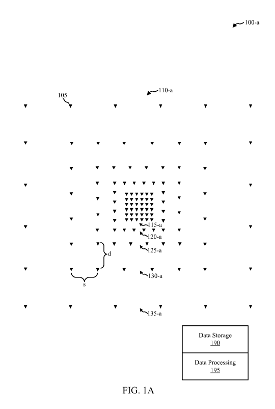
[0015] Turning now to the figures, FIG. lA is a diagram illustrating one
example of a
seismic data acquisition system 100-a in accordance with aspects of the
present disclosure.
The system 100-a illustrated in FIG. lA includes a plurality of seismic
receivers 105
positioned in an acquisition geometry 110-a that may allow surface phase
velocity
information to be recorded and subsequently used to remove shallow layer noise
from the
acquired seismic data. Each seismic receiver 105 may include, for example, a
geophone, an
accelerometer, or another motion sensor, and may measure motion in 1, 2, or 3
dimensions
(e.g., x, y, and z). Each seismic receiver 105 may additionally or
alternatively include a
pressure sensor (e.g., in marine implementations). Each seismic receiver 105
may generate
one or more traces corresponding to the one or more motion or pressure
measurements, and
may store the trace(s) locally and/or transmit the traces elsewhere for
storage.
[0016] As illustrated in FIG. 1A, some embodiments of the system 100-a
include data
storage 190, which may be coupled to the plurality of seismic receivers 105
and may store
seismic data acquired by the seismic receivers 105 for later processing by
data processing
195, as described more fully below. Although not shown in FIG. 1A, the seismic
data
acquisition system 100-a may further include various control systems,
including for example
wired or wireless communication between the seismic receivers 105 and the data
storage 190
3
CA 03002642 2018-04-19
WO 2016/064845 PCT/US2015/056421
and data processing 195, seismic sources (active or passive), and so forth.
Further, while the
system 100-a shown in FIG. lA is described herein with reference to land-based
seismic
systems, it will be appreciated that similar techniques may be used in other
seismic systems,
including for example ocean bottom cable seismic data acquisition systems,
ocean bottom
node seismic data acquisition systems, and so forth. These and all other
implementations of
the techniques described herein are within the scope of the present disclosure
and appended
claims.
[0017] The acquisition geometry 110-a in FIG. lA includes a plurality of
regions 115-a,
120-a, 125-a, 130-a, 135-a together forming an array with non-uniformly spaced
seismic
receivers 105. While FIG. lA illustrates 5 regions 115-a, 120-a, 125-a, 130-a,
135-a, other
contemplated embodiments may include fewer regions (e.g., 2, 3, or 4) or more
regions (e.g.,
6, 7, 8, 9, 10, or even more than 10). Similarly, while other figures of the
present disclosure
show certain numbers of regions, it will be appreciated that these are merely
given as
examples, and that the acquisition geometry for specific seismic surveys may
vary greatly.
[0018] In some embodiments, and as shown in FIG. 1A, the seismic receivers
105 may be
positioned in a manner to enable them to record surface phase velocity
information associated
with near-surface noise. This may be accomplished by positioning the seismic
receivers 105
in an array having a plurality of regions 115-a, 120-a, 125-a, 130-a, 135-a,
each region in the
array having a respective average spacing between seismic receivers 105, with
the average
spacing in a second region 120-a being greater than the average spacing in a
first region 115-
a that is adjacent to the second region, further with the average spacing in a
third region 125-a
being greater than the average spacing in the second region 120-a. In these
embodiments, the
average spacing between seismic receivers 105 may increase from the first
region 115-a to
the other regions 120-a, 125-a, 130-a, 135-a, with the average spacing between
seismic
receivers 105 in each region being progressively greater than the average
spacing between
seismic receivers 105 in the next-inner region. In other words, the innermost
region 115-a
may have the lowest average spacing between seismic receivers 105 (i.e., a
higher density of
seismic receivers 105), with successive regions 120-a, 125-a, 130-a, 135-a
having
progressively greater average spacings between seismic receivers 105 (i.e.,
lower density of
seismic receivers 105). It will be appreciated that while these embodiments
may be cost-
effective (because larger regions have progressively fewer receivers), in
alternative
embodiments, the average spacing between receivers may not monotonically
increase. For
4
CA 03002642 2018-04-19
WO 2016/064845 PCT/US2015/056421
example, the innermost region 115-a may have the smallest average spacing
between seismic
receivers 105, but the third region 125-a may have a smaller average spacing
between seismic
receivers 105 than the second region 120-a, even though the second region 120-
a is further
towards the middle of the array than the third region 125-a.
[0019] The average spacing of the seismic receivers 105 within a given
region 115-a, 120-
a, 125-a, 130-a, 135-a of the array may be with reference to one-dimensional
spacing (e.g., in
either the x or y direction), with reference to two-dimensional spacing (e.g.,
in both the x and
y direction), with reference to an angular spacing (e.g., in a polar
coordinate system), and so
forth. In still other examples, the average spacing of the seismic receivers
105 may be with
reference to an average density of seismic receivers 105 (e.g., receivers per
surface area of
the earth). Also, in some embodiments, the average spacing between seismic
receivers 105
may not be uniformly referenced between different regions 115-a, 120-a, 125-a,
130-a, 135-a
- for example, the average spacing may be with reference to density in the
inner most region
115-a, and may be with reference to angular or two-dimensional spacing for the
other
regions, 120-a, 125-a, 130-a, 135-a. Generally any method of measuring and
accounting for
spacing between seismic receivers 105 may be used in various aspects of the
present
disclosure.
[0020] In some embodiments, and as shown in FIG. 1A, the regions 115-a, 120-
a, 125-a,
130-a, 135-a may be defined by a plurality of rings, with the first region 115-
a being an
innermost region associated with a first ring, the second, third, and fourth
regions 120-a, 125-
a, 130-a being middle regions associated with second, third, and fourth rings,
and the fifth
region 135-a being an outermost region associated with an outermost ring. In
this manner,
each successive region may circumscribe the next-inner region (geographically
speaking), so
that the second region 120-a surrounds and circumscribes the first region 115-
a, the third
region 125-a surrounds and circumscribes the second region 120-a, and so
forth. The rings
defining the regions 115-a, 120-a, 125-a, 130-a, 135-a may further be
concentric in some
embodiments, such that each of the regions 115-a, 120-a, 125-a, 130-a, 135-a
share a
common midpoint, which may be part of the first region 115-a. In other
embodiments,
however, the regions need not be defined in this manner - for example, they
may not share a
common midpoint, they may not be symmetrical, they may not be concentric, and
so forth.
CA 03002642 2018-04-19
WO 2016/064845 PCT/US2015/056421
[0021] In one specific embodiment, and again as shown in FIG. 1A, the
average spacing
(denoted s in FIG. 1A) between seismic receivers in one region 130-a may be
substantially
similar to an average distance (denoted d in FIG. 1A) between that region 130-
a and the next-
inner region 125-a. The spacing s may be substantially similar to the distance
d if the two
measurements are within 0.1%, 1%, 5%, 10%, 20%, or 25% of one another, or if
the two
measurements are the same.
[0022] Additionally, the actual spacing between seismic receivers 105
within a region may
allow for some randomness of the positions of the seismic receivers 105, as
long as the
average spacing s is maintained. The actual spacing between seismic receivers
105 in a
region may vary by as much as 30% while still preserving the average spacing
s.
[0023] It will be appreciated that the example acquisition geometry 110-a
shown in FIG.
lA may reduce the number of seismic receivers needed to acquire a seismic
survey (e.g., 116
in FIG. 1A) as compared with a traditional acquisition geometry that may
require a
substantially larger number of seismic receivers (e.g., 1600 in FIG. 1A) to
avoid aliasing
effects in the recorded noise.
[0024] FIGs. 1B and 1C illustrate additional examples of seismic data
acquisition systems
in accordance with aspects of the present disclosure. Whereas the acquisition
geometry 110-a
of FIG. lA was generally in the shape of a square ring array, FIGs. 1B and 1C
illustrate
hexagonal ring array receiver patterns. For example, FIG. 1B illustrates a
seismic data
acquisition system 100-b that includes a plurality of seismic receivers 105
positioned in an
acquisition geometry 110-b. Acquisition geometry 110-b is a hexagonal ring
array receiver
pattern that includes some randomness in the location of the seismic receivers
105. The
acquisition geometry 110-b includes a number of regions, including regions 115-
b, 120-b,
and 125-b. The spacing and/or density of the seismic receivers 105 in at least
one of the
regions 115-b, 120-b, 125-b may differ from the spacing and/or density of
seismic receivers
105 in the other regions 115-b, 120-b, 125-b. In another example, FIG. 1C
illustrates a
seismic data acquisition system 100-c that includes a plurality of seismic
receivers 105
positioned in an acquisition geometry 110-c. Acquisition geometry 110-c is a
hexagonal ring
array receiver pattern that does not include randomness in the location of the
seismic
receivers 105. The acquisition geometry 110-c includes a number of regions,
including
regions 115-c, 120-c, and 125-c. The spacing and/or density of the seismic
receivers 105 in
6
CA 03002642 2018-04-19
WO 2016/064845 PCT/US2015/056421
at least one of the regions 115-c, 120-c, 125-c may differ from the spacing
and/or density of
seismic receivers 105 in the other regions 115-c, 120-c, 125-c.
[0025] The seismic data acquisition systems 100-a, 100-b, and 100-c
demonstrate that
different geographies and degrees of randomness may be used. The variations
may include
different patterns (e.g., hexagonal and square ring patterns). The variations
may include
different degrees of randomness in the locations of the seismic receivers 105.
Further, the
variations may include different numbers and densities of seismic receivers
105. Additional
variations are described below with respect to FIGs. 2A-2D.
[0026] FIGs. 2A-2D are diagrams illustrating additional examples of
acquisition
geometries that may be used in the seismic data acquisition systems 100 of
FIGs. 1A-1C in
accordance with aspects of the present disclosure. FIGs 2A-2D are similar to
FIGs. 1A-1C,
except that instead of showing individual seismic receivers 105, FIGs. 2A-2D
merely show
rings that may define the different regions of an array for seismic data
acquisition.
Nonetheless, as previously mentioned, the present disclosure is not limited to
embodiments
with concentric rings, but includes other arrays as described above.
[0027] Referring first to FIG. 2A, a diagram 205 is shown illustrating four
concentric
square-shaped rings which define four respective regions. The arrangement of
rings in FIG.
2A is, in some aspects, similar to the arrangement in FIG. 1A. As shown in
FIG. 2A, in some
embodiments, distances between neighboring rings may get progressively larger
from an
innermost ring to an outermost ring. More specifically, as shown in FIG. 2A,
in some
embodiments, a first distance between a second concentric ring defining a
second region and
a third concentric ring defining a third region may be greater than a second
distance between
the second concentric ring and a first concentric ring defining the first
region.
[0028] Referring now to FIG. 2B, the concentric rings defining the
different regions of the
array may take forms other than squares. For example, FIG. 2B shows a diagram
210 of
concentric rings that define a circular shape. In still other embodiments,
other shapes of rings
are also contemplated, such as an ellipse, an octagon, a hexagon, a rectangle,
a triangle, and
so forth. Also, the concentric rings defining the different regions of the
array may only be
partial rings or unbalanced arrays, as shown in the diagram 215 of FIG. 2C. In
still other
embodiments, the concentric rings may not be symmetrical. As another example,
in some
embodiments, the distances between neighboring rings may not progressively
increase from
7
CA 03002642 2018-04-19
WO 2016/064845 PCT/US2015/056421
one ring to another ¨ as shown for example in FIG. 2D, the distances between
neighboring
rings defining the different regions may be substantially constant among the
different rings
defining the different regions.
[0029] Referring now to FIGs. 2A-2D, in some embodiments, the average
spacing between
seismic sources in a first region (e.g., the inner or middlemost region) may
be at least three
times less than the average spacing in a neighboring or adjacent second region
(e.g., the next-
inner region). In other embodiments, the ratio of spacing between neighboring
or adjacent
regions may be smaller or larger, such as 1.5x, 2x, 4x, 6x, 8x, and so forth.
Also, in some
embodiments, the average spacing between seismic receivers may be smallest in
the inner or
middlemost region of all of the regions in an array, with the average spacing
between seismic
receivers getting progressively larger in regions progressively further away
from the inner or
middlemost region.
[0030] FIGs. 3A-3B are diagrams illustrating additional examples of
acquisition
geometries that may be used in the seismic data acquisition systems 100 of
FIGs. 1A-1C. As
illustrated in FIG. 3A, in some embodiments, the seismic receivers associated
with each
region may be positioned on boundaries (e.g., the concentric rings described
above) that
define the respective regions. As illustrated in FIG. 3B, however, in other
embodiments, the
seismic receivers associated with each region may be positioned in spaces
between the
boundaries defining the respective regions. Also, in some embodiments, the
seismic receiver
positioning shown in FIGs. 3A and 3B may be combined such that in some
regions, the
seismic receivers are positioned on boundaries for those regions, and
positioned in spaces
between boundaries for other regions.
[0031] FIGs. 4A-4B are diagrams illustrating still additional examples of
acquisition
geometries that may be used in the seismic data acquisition systems 100 of
FIGs. 1A-1C.
Referring first to the diagram 405 in FIG. 4A, one ring 405 defining a region
of the array is
shown, where the seismic receivers are randomly or pseudo-randomly spaced
relative to one
another within a specific region. The randomness factor associated with the
randomly or
pseudo-randomly spaced receivers may be 0.5 or less in some embodiments.
Notwithstanding the diagram 405 in FIG. 4A, in other implementations of the
present
disclosure, some or all of the seismic receivers may be positioned in a non-
random manner.
8
CA 03002642 2018-04-19
WO 2016/064845 PCT/US2015/056421
[0032] Referring now to FIG. 4B, a side-view diagram 410 is shown that
illustrates the
depths at which the seismic receivers may be buried. As illustrated in FIG.
4B, in some
embodiments, seismic receivers may be positioned at varying depths at or near
the earth
surface (which may be underwater in marine implementations). The example
illustrated in
FIG. 4B shows seismic receivers in a first (middlemost) region positioned at
the earth
surface, and seismic receivers in a second region (adjacent to the first
region) positioned
below the earth surface. FIG. 4B further illustrates that for regions that are
progressively
further away from the middlemost region, the seismic receivers may be buried
at
progressively greater depths. In other embodiments, however, all of the
seismic receivers
may be positioned at the same depth, which may be at or near the surface.
[0033] FIG. 5 is a flow chart illustrating a method 500 of seismic data
acquisition in
accordance with aspects of the present disclosure. At block 505 of the method
500 shown in
FIG. 5, a plurality of seismic receivers may be positioned in an array having
a plurality of
regions, as described above with reference to FIGs. 1A-4B. Each region in the
array may
have a respective average spacing between seismic receivers in that respective
region, with
the average spacing in a second (outer) region of the plurality of regions
being greater than
the average spacing in a first (inner) region of the plurality of regions that
is adjacent to the
second region.
[0034] At block 510 of the method 500 shown in FIG. 5, seismic data may be
acquired
utilizing the plurality of seismic receivers positioned at block 505. At block
515 of the
method 500 shown in FIG. 5, the seismic data acquired using the plurality of
receivers at
block 510 may be processed in order to, for example, remove noise associated
with shallow
layers of the earth.
[0035] Method 500 may be varied by acquiring seismic data from multiple
arrays that
touch or overlap. Therefore, in method 500, a first array may be defined by a
first plurality of
seismic receivers positioned at block 505. A second array may be defined by a
second
plurality of seismic receivers. The second plurality of seismic receivers may
be positioned in
a manner similar to the first plurality of seismic receivers of the first
array. At block 510,
then, seismic data may be acquired utilizing the first plurality of seismic
receivers of the first
array and the second plurality of seismic receivers of the second array. At
block 515, the
9
CA 03002642 2018-04-19
WO 2016/064845 PCT/US2015/056421
acquired seismic data may be processed in order to, for example, remove noise
associated
with shallow layers of the earth.
[0036] FIG. 6 is a flow chart illustrating a method 600 of processing
seismic data in
accordance with aspects of the present disclosure. The method 600 may be
performed by the
data processing 195 in FIGs. 1A-1C, and may be an example of one or more
aspects of block
515 in FIG. 5.
[0037] At block 605 of the method 600 shown in FIG. 6, traces recorded by
respective
seismic receivers may be weighted. The weighting in block 605 may be done
prior to
transforming the acquired seismic data, as discussed below with reference to
block 610. In
some embodiments, the trace for each respective seismic receiver may be
weighted based at
least in part on an average spacing between the respective seismic receiver
and one or more
(e.g., 1, 2, 3, 4, 5, 6, 7, 8, and so forth) neighboring receivers, with the
weighting being a
factor of the average spacing between the respective seismic receiver and the
one or more
neighboring seismic receivers raised to a power between 1 and 2 (e.g., 1.5 or
1.6 in some
examples) . In some embodiments, the traces corresponding to seismic receivers
positioned
in inner regions of an array (with a lower average spacing between seismic
receivers) may be
weighted less than traces corresponding to seismic receivers positioned in
outer regions of the
array (with a higher average spacing between seismic receivers), in order to
normalize the
weights given to different traces and help offset the non-uniformity of the
seismic receiver
spacing.
[0038] At block 610 of the method 600 shown in FIG. 6, the acquired seismic
data (which
may optionally have been weighted at block 605) may be transformed into a
surface phase
velocity domain using a beam forming operation. The beam forming operation may
be one
or more of a radon transform, a slant stack inversion, or a radon inversion
transform. In some
embodiments, common receiver gathers may be created for shots along a common
azimuth
(e.g., 45 degree azimuth range), using a seismic receiver near the center of
the array.
[0039] In some embodiments, a sparsity constraint may be applied during the
transformation of the acquired seismic data in block 610. The sparsity
constraint may operate
to encourage a sparse or spike angular decomposition result in the results of
the beam
forming operation. Such a sparsity constraint may be applied by, for example,
iteratively
applying a beam forming operation, with each subsequent iteration of the beam
forming
CA 03002642 2018-04-19
WO 2016/064845 PCT/US2015/056421
operation penalizing a surface phase velocity component by the inverse of the
amplitude of
that same surface phase velocity component from the previous iteration of the
beam forming
operation.
[0040] At block 615 of the method 600 shown in FIG. 6, noise (such as
shallow layer or
near surface noise) may be identified in the acquired seismic data based at
least in part on
surface phase velocities observed in the acquired seismic data once
transformed into the
surface phase velocity domain. In some embodiments, all energy that is slower
than a
predetermined threshold (e.g., 12,000 feet per second) may be considered
noise.
[0041] At block 620 of the method 600 shown in FIG. 6, the noise identified
at block 615
may be removed. For the example given above, block 620 may include filtering
the seismic
data to preserve energy faster than the predetermined threshold while
discarding all of the
rest.
[0042] At block 625 of the method 600 shown in FIG. 6, the acquired seismic
data may be
inversely transformed (e.g., back to the time-space domain or the time-
frequency domain)
following removal of the noise at block 620.
[0043] With reference still to the method 600 shown in FIG. 6, in some
embodiments, time
shift corrections may be computed and applied for at least some of the seismic
receivers
before, during, or after the beam forming operation of block 610 such that the
time shift
corrections vary smoothly in the surface phase velocity domain. The time shift
corrections
may be computed to enhance the sparse or spiky characteristics of the acquired
seismic data
in the surface phase velocity domain, and may help account for velocity
anomalies near the
respective seismic receivers (e.g., a formation near the seismic receiver that
causes seismic
waves to propagate anomalously fast or slow). In some embodiments, the
corrections may
vary smoothly by the energy incident angle. Also, in various embodiments,
source statics
corrections can be computed and applied, and various other, conventional noise
attenuation
techniques can be employed together with the methods described herein.
[0044] With reference still to the method 600 shown in FIG. 6, in some
embodiments,
positioning errors may be computed for at least some of the plurality of
seismic receivers
before, during, or after the beam forming operation of block 610. The
positioning errors may
be computed to enhance the sparse or spiky characteristics of the acquired
seismic data in the
11
CA 03002642 2018-04-19
WO 2016/064845 PCT/US2015/056421
surface phase velocity domain, and may help account for errors in the
determined positions of
the seismic receivers.
[0045] FIG. 7 is a diagram 705 illustrating aspects relating to a beam
forming operation,
such as the beam forming operation described above with reference to block 610
of FIG. 6.
In FIG. 7, a plurality of different seismic waves are shown arriving at
various angles relative
to the vertical. As noted in FIG. 7, the seismic waves arriving from a nearly
horizontal angle
have a relatively slow surface phase velocity and are associated with very
shallow surface
noise. Seismic waves arriving from a nearly vertical angle have a relatively
fast surface
phase velocity and are associated with seismic energy from deep geological
layers. FIG. 7
also shows seismic waves arriving at intermediate angles with a medium surface
phase
velocity, which are associated with shallow surface noise.
[0046] With reference still to FIG. 7, the beam forming operation in block
610 of FIG. 6
may include adding time corrections to traces at various angles (so that the
time corrections
match the tilt of the beam forming angle). More specifically, in some
embodiments, the
beam forming operation may scan over a plurality of different angles, with the
different
angles specifying the time shifts to apply to the traces as the array is, in
essence, tuned to the
different possible arrival angles. The beam forming operation may scan over
angles in all
three dimensions (e.g., over all dips and azimuths), with the received energy
constructively
interfering when the beam forming scan angle matches the actual arrival angle.
In this
manner, the beam forming operation may be used to identify arrival angles (dip
and azimuth)
for various seismic events in the acquired seismic data. The arrival angles
may be associated
with the surface phase velocity of the associated seismic events, and can thus
be used, as
described above with reference to block 615, to remove slow, shallow surface
noise from the
acquired seismic data.
[0047] As also described above, several techniques may be employed in the
beam forming
operation to account for the non-uniform spacing of the seismic receivers
within the array.
For example, the recorded seismic traces may be weighted different in
different regions. By
normalizing the influence of traces based on the average spacing between the
respective
receiver and its neighboring receiver(s), the beam forming operation may more
uniformly
consider the data so that the traces in the inner or middlemost region aren't
overly influential
in the beam forming operation. Another technique that may be employed in the
beam
12
CA 03002642 2018-04-19
WO 2016/064845 PCT/US2015/056421
forming operation as described above is a sparsity normalization. A sparsity
normalization
may isolate or localize energy to help reduce the smearing of energy that may
result from the
beam forming operation. Motivated by the assumption that arriving energy is
not smooth, but
rather bursty or spiky, a sparsity normalization may mathematically encourage
energy to
focus on a few locations during the beam forming operation as opposed to
smoothly and
continuously varying over time.
[0048] Turning now to FIG. 8, a diagram 805 illustrating an example of
seismic data that
has been transformed into a surface phase velocity domain is shown. The
diagram in FIG. 8
may be for one component of motion (e.g., the z or vertical component), and
may be the
result of applying a simple slant stack beam forming operation. Each point in
the diagram
805 in FIG. 8 is associated with a specific angle. The angle may include a dip
(with the
highest dip values at the center of the diagram 805 and lower dip values at
the outer portions
of the diagram 805) and an azimuth (with the azimuth varying around the
circumference of
the diagram 805). As illustrated in FIG. 8, the different dip values may be
associated with
different arrival speeds (varying from 600 ft/sec to 3400 ft/sec in FIG. 8) ¨
which may
correspond to tuning the array to different arrival speeds (e.g., surface
phase velocities)
during the beam forming operation. The shading in the diagram 805 represents
the amplitude
of energy received at each given dip and azimuth.
[0049] With reference still to FIG. 8, reference numeral 810 (the inner or
middlemost
circle) may represent reflections, reference numeral 815 may refer to
refracted energy,
reference number 820 may refer to guided surface waves, reference numeral 825
may refer to
air waves, and reference numeral 830 may refer to the line along which energy
is directly
received from the seismic source. In some embodiments, noise can be removed
(e.g., in
operation 620 of FIG. 6), by getting rid of all of the energy in FIG. 8 other
than that in the
smallest circle 810 (e.g., by setting values to zero), and then inverse
transforming the data
back out of the surface phase velocity domain.
[0050] By analyzing the noise as illustrated in FIG. 8, noise-signal ratios
may be
characterized for air noise (how deep to bury the seismic receivers), direct
surface waves (and
velocity), back scattered surface waves, ambient noise vs. source noise,
guided waves,
refractions Z component-horizontal component coupling. This may further
provide what
noise attenuation needs to be applied to normal data processing, which seismic
source shots
13
CA 03002642 2018-04-19
WO 2016/064845 PCT/US2015/056421
and/or which seismic traces are noisy and need editing, what changes are
needed for future
acquisition layouts, and so forth.
[0051] Referring now to FIGs. 1A-8, it will be appreciated that different
entities may
perform different aspects of the present disclosure. For example, one entity
may position the
seismic receivers and acquire the seismic data, while another entity performs
the subsequent
data processing. It will thus be understood that acquiring seismic data as
described herein
may be performed by a first entity with the intent of having a second,
separate entity perform
some or all of the disclosed processing operations. Similarly, the data
processing techniques
described herein can be performed by one entity to data acquired by another
entity in
accordance with the present disclosure (e.g., the data processing can be
performed using
seismic data that has been acquired using one or more of the acquisition
geometries described
above). In other examples, however, a single entity may perform both the
acquisition and
subsequent data processing.
[0052] FIG. 9 illustrates an exemplary computer system 900, which may be
used to
perform one or more of the operations in the various methods described herein.
As illustrated
in FIG. 9, the computer system 900 may include at least one Central Processing
Unit (CPU)
911, a memory 912, a data storage 916, an input/output device 917, and a
network interface
device 919. While a single CPU 911 is shown in FIG. 9, in alternative
embodiments, a
plurality of CPUs may be implemented within the computer system, or multiple
computer
systems may be combined as a processing cluster.
[0053] The input/output device 917 may include devices such as a mouse,
keyboard,
trackball, stylus pen, touchscreen, display (e.g., computer monitor), and the
like. The
network interface device 919 may be any entry/exit device configured to allow
network
communications between the computer system 900 and another device, e.g.,
another
computer system, a server, and the like. In one embodiment, the network
interface device
919 may be a network adapter or other network interface card (NIC).
[0054] Data storage 916 may be a Direct Access Storage Device (DASD).
Although it is
shown as a single unit, it could be a combination of fixed and/or removable
storage devices,
such as fixed disc drives, floppy disc drives, tape drives, removable memory
cards, or optical
storage. The memory 912 and data storage 916 could be part of one virtual
address space
spanning multiple primary and secondary storage devices.
14
CA 03002642 2018-04-19
WO 2016/064845 PCT/US2015/056421
100551 The memory 912 may be a random access memory that is sufficiently
large to hold
the necessary programming and data structures of the present disclosure. While
memory 912
is shown as a single entity, it should be understood that memory 912 may in
fact comprise a
plurality of modules, and that memory 912 may exist at multiple levels, from
high speed
registers and caches to lower speed but larger DRAM chips. The memory 912 may
include
an operating system 913. Any operating system supporting the functions
disclosed herein
may be used.
[0056] Memory 912 may also include a noise removal program 922 which, when
executed
by CPU 911, enables the identification and removal of noise from recorded
seismic data as
described herein. Generally speaking, the memory 912 may include one or more
programs
configured to remove noise (such as slow moving surface noise) from recorded
seismic data,
which may be stored in the memory 912 and/or data storage 916, and the
programs may be
further configured to display or otherwise provide the seismic data with the
noise removed.
[0057] In methodologies directly or indirectly set forth herein, various
steps and operations
are described in one possible order of operation, but those skilled in the art
will recognize that
the steps and operations may be rearranged, replaced, or eliminated without
necessarily
departing from the spirit and scope of the disclosed embodiments. Further, all
relative and
directional references used herein are given by way of example to aid the
reader's
understanding of the particular embodiments described herein. They should not
be read to be
requirements or limitations, particularly as to the position, orientation, or
use of the invention
unless specifically set forth in the claims.
[0058] Furthermore, in various embodiments, the invention provides numerous
advantages
over the prior art. However, although embodiments of the invention may achieve
advantages
over other possible solutions and/or over the prior art, whether or not a
particular advantage is
achieved by a given embodiment is not limiting of the invention. Thus, the
described aspects,
features, embodiments and advantages are merely illustrative and are not
considered elements
or limitations of the appended claims except where explicitly recited in a
claim(s). Likewise,
reference to "the invention" shall not be construed as a generalization of any
inventive
subject matter disclosed herein and shall not be considered to be an element
or limitation of
the appended claims except where explicitly recited in a claim(s).
CA 03002642 2018-04-19
WO 2016/064845 PCT/US2015/056421
[0059] One embodiment of the invention is implemented as a program product
for use
with a computerized system. The program(s) of the program product defines
functions of the
embodiments (including the methods described herein) and can be contained on a
variety of
computer-readable media. Illustrative computer-readable media include, but are
not limited
to: (i) information permanently stored on non-writable storage media (e.g.,
read-only memory
devices within a computer such as CD-ROM disks readable by a CD-ROM drive);
(ii)
alterable information stored on writable storage media (e.g., floppy disks
within a diskette
drive or hard-disk drive); and (iii) information conveyed to a computer by a
communications
medium, such as through a wireless network. The latter embodiment specifically
includes
information downloaded from the Internet and other networks. Such computer-
readable
media, when carrying computer-readable instructions that direct the functions
of the present
invention, represent embodiments of the present invention.
[0060] In general, the routines executed to implement the embodiments of
the invention,
may be part of an operating system or a specific application, component,
program, module,
object, or sequence of instructions. The computer program of the present
invention typically
is comprised of a multitude of instructions that will be translated by the
computer into a
machine-readable format and hence executable instructions. Also, programs are
comprised
of variables and data structures that either reside locally to the program or
are found in
memory or on storage devices.
16