Note: Descriptions are shown in the official language in which they were submitted.
LOCAL LOCATION MAPPING METHOD AND SYSTEM
FIELD OF THE INVENTION
[0001] The present invention pertains to a local location mapping method
and system
to create a map from location data and orientation data. In particular, the
present system and
method use dead reckoning deltas obtained from inertial and orientation
sensors to interpolate
a travel path using travel path features.
BACKGROUND
[0002] The location of a mobile device in an environment can be
determined using
many different techniques. In outdoor environments Global Positioning System
(GPS) data or
cellular base station data can be used to triangulate a device location. Data
associated with a
wireless access point, such as an 802.11 WiFi access point (i.e., Institute of
Electrical and
Electronics Engineers (IEEE) 802.11 standards) or wireless local area network
and other signal-
based indoor location technologies can also be used for indoor location
determination by
estimating degradation of signal strength over distance in space from a known
location,
beacon or anchor node. Another method of device location relies on storing pre-
recorded
calibration WiFi measurement data (i.e., WiFi fingerprinting) in order to
generate a radio
frequency (RE) map of a building. Based on the location of either the cellular
base station or
beacon, the mobile computing device can calculate its exact position using
triangulation
methods with multiple stationary beacons.
[0003] Simultaneous Localization and Mapping (SLAM) is a technique used
to construct
or update a map of an unknown environment while simultaneously keeping track
of an agent's
location within it. Generally, SLAM consists of multiple parts: landmark
extraction; data
association; state estimation; state update and landmark update. SLAM
techniques have been
1
CA 3004246 2018-05-08
=
used for estimating the poses or position of an electronic device in a space
and building a map
of an unknown environment. Visual, ultrasound, signal strength or laser scans
can also be
collected as a mobile device moves through an indoor environment, which can be
combined
with odometry information to estimate the device trajectory. Overlaying this
data can yield a
map showing the floor plan of an indoor space and provide a wifi-fingerprint
or signal strength
map of an environment. Once a map is generated, a user can navigate through
the space and
locate based on an established beacon strength map.
[0004] In an example of indoor localization, US 9,288,632 to Yang et al.
describes a
device and method for detecting the precise indoor location of a portable
wireless device
based on a WiFi simultaneous localization and mapping (SLAM) algorithm that
implements
spatial and temporal coherence. In one implementation, a SLAM algorithm
includes WiFi
similarities and inertial navigational system (INS) measurement data as
location estimates for
the spatial and temporal coherences implementations to constitute the WiFi-
SLAM algorithm.
[0005] In another example of indoor localization, US 9,459,104 to Le
Grand describes
systems and methods for performing a multi-step approach for map generation
and device
localizing using data collected by the device and observations of
interdependencies between
the data using simultaneous localization and mapping (SLAM) optimization in
combination with
signal strength maps.
[0006] In an environment with few or no emittive beacons or visual
landmarks from
which to localize and no absolute location identifiers there remains a need
for localizing a
mobile device. There further remains a need for a system and method for
generating a map in
an unknown environment without anchor nodes, beacons or landmarks.
[0007] This background information is provided for the purpose of making
known
information believed by the applicant to be of possible relevance to the
present invention. No
admission is necessarily intended, nor should be construed, that any of the
preceding
information constitutes prior art against the present invention.
2
CA 3004246 2018-05-08
SUMMARY OF THE INVENTION
[0008] An object of the present invention is to provide a local location
mapping system
and method to create a map from travel trajectory measurements and dead
reckoning deltas
obtained from inertial and orientation sensors to interpolate a travel path
using travel path
features.
[0009] In an aspect there is provided a method of creating a map of an
environment
with a mobile device, the method comprising: obtaining a travel trajectory for
the mobile
device in the environment, the travel trajectory comprising a sequence of
poses, each pose
comprising location data and orientation data with an associated time stamp;
calculating a
travel path for the mobile device based on the travel trajectory; identifying
at least one path
feature on the travel path, the at least one path feature comprising a subset
of the sequence of
poses in the travel trajectory; and overlaying at least two instances of the
at least one identified
path feature to calculate a travel path and constrain the map.
[0010] In an embodiment, the method comprises obtaining exteroceptive
data from
the mobile device and using the exteroceptive data to further define each
pose. In another
embodiment, the exteroceptive data is collected from at least one of a
magnetometer, sonar
sensor, sound pressure sensor, light sensor, barometer, altimeter,
thermometer, microphone,
IR sensitive sensor, ultrasonic sensor, radiofrequency sensor, and camera.
[0011] In another embodiment, the method further comprises identifying a
location of
an additional mobile device on the map by: obtaining a travel trajectory for
the additional
mobile device in the environment; extracting at least one path feature from
the travel trajectory
of the additional mobile device; and overlaying the extracted at least one
path feature of the
additional mobile device to the calculated travel path to locate the
additional mobile device on
a travel path on the map.
3
CA 3004246 2018-05-08
[0012] In another aspect there is provided a method for localizing a
mobile device in a
mapped environment, the method comprising: obtaining a travel trajectory for
the mobile
device in the environment, the travel trajectory comprising a sequence of
poses, each pose
comprising location data and orientation data with an associated time stamp;
calculating a
travel path for the mobile device based on the travel trajectory; extracting
at least one path
feature from the travel path, the at least one path feature comprising a
subset of the sequence
of poses in the travel trajectory; and searching for a similar path feature in
the mapped
environment to locate the mobile device in the mapped environment.
[0013] In another aspect there is provided a system for creating a map of
an
environment, the system comprising: a mobile device comprising: an inertial
sensor; an
orientation sensor; and a clock; a processor for: obtaining a travel
trajectory for the mobile
device in the environment, the travel trajectory comprising a sequence of
poses, each pose
comprising location data and orientation data with an associated time stamp,
the location data
and orientation data obtained from the inertial sensor and orientation sensor;
calculating a
travel path for the mobile device based on the travel trajectory; identifying
at least one path
feature on the travel path, the at least one path feature comprising a subset
of the sequence of
poses in the travel trajectory; and overlaying at least two instances of the
at least one identified
path feature to calculate a travel path and constrain the map; and a mapping
module for
generating the map.
[0014] In another aspect there is provided a method of creating a map of
an
environment with a mobile device comprising a translation sensor and an
orientation sensor,
the method comprising: obtaining a dead reckoning data set for a travel path
of the mobile
device in the environment, the dead reckoning data set comprising data
obtained from the
translation sensor and the orientation sensor; calculating a travel path for
the mobile device
based on the dead reckoning data set, the travel path comprising a series of
incremental dead
reckoning deltas; searching for at least one path feature on the travel path
using the set of
dead reckoning deltas; and overlaying any identified path features to
constrain the map.
4
CA 3004246 2018-05-08
[0015] In an embodiment of the method, the translation sensor comprises
an
accelerometer.
[0016] In another embodiment, the orientation sensor comprises one or
more
gyroscope, compass and magnetometer.
[0017] In another embodiment, the at least one path feature has a
distinctive sequence
of dead reckoning deltas relative to the collected path features, and the
method further
comprises matching the distinctive sequence of dead reckoning deltas to the
environment to
constrain the map.
[0018] In another embodiment, the method further comprises identifying a
location of
at least one additional mobile device on the map by: obtaining an additional
path feature from
a dead reckoning data set for a travel path of the additional mobile device in
the environment;
extracting at least one path feature from the travel path of the additional
mobile device, the
travel path feature comprising a series of dead reckoning delta vectors; and
overlaying the
extracted path features to locate the additional mobile device on the map.
[0019] In another embodiment, the method further comprises obtaining
geospatial
data from one or more anchor node.
[0020] In another embodiment, the inertial sensor is in an inertial
measurement unit.
[0021] In another embodiment, the method further comprises locating at
least one
asset in the environment.
[0022] In another embodiment, the asset comprises an anchor node.
[0023] In another aspect there is provided a method for localizing a
mobile device in a
mapped environment, the mobile device comprising a translation sensor and an
orientation
sensor, the method comprising: obtaining a dead reckoning data set from the
mobile device in
the environment; calculating a travel path for the mobile device from the dead
reckoning data
CA 3004246 2018-05-08
set, the travel path comprising incremental dead reckoning delta vectors;
extracting at least
one path feature for the travel path from the dead reckoning delta vectors;
and searching for a
similar path feature for the environment to locate the mobile device in the
mapped
environment.
[0024] In an embodiment, the method further comprises matching the
extracted path
feature to a single path feature on a previously created map. In another
embodiment, the
method further comprises returning the best match to locate the mobile device
in the known
environment.
[0025] In another embodiment, the method further comprises matching the
extracted
path features to multiple matches; and scoring each of the multiple matches to
find the best
match. In another embodiment, the method further comprises returning more than
one match.
[0026] In another embodiment, the method further comprises obtaining
additional data
from the mobile device via additional sensor readings. In another embodiment,
the additional
data is an altimeter reading, barometer reading, light meter reading, sound
reading, camera,
code scanner, conversational interface, user interaction, or anchor node
interaction.
[0027] In another aspect there is provided a system for creating a map of
an
environment, the system comprising: a mobile device comprising: a translation
sensor; an
orientation sensor; and a processor; a computing device capable of
automatically: obtaining a
dead reckoning data set for a travel path of the mobile device in the
environment, the dead
reckoning data set comprising data obtained from the translation sensor and
the orientation
sensor; calculating a travel path for the mobile device based on the dead
reckoning data set,
the travel path comprising a series of incremental dead reckoning deltas; and
searching for at
least one path feature on the travel path using the set of dead reckoning
deltas; and a
mapping module for generating the map.
6
CA 3004246 2018-05-08
[0028] In another embodiment, the system further comprises a graphical
user interface
for displaying the map.
BRIEF DESCRIPTION OF THE FIGURES
[0029] For a better understanding of the present invention, as well as
other aspects and
further features thereof, reference is made to the following description which
is to be used in
conjunction with the accompanying drawings, where:
[0030] Figure 1A illustrates an example of a mobile device and system
configured to
collect data to map an environment;
[0031] Figure 1B illustrates a specific example of a mobile device and
system
configured to collect data to map an environment;
[0032] Figure 2 is a flowchart depicting an example method of calculating
a travel path
and creating a map for an unknown environment;
[0033] Figure 3 depicts a vector transformation between a fixed reference
frame and a
reference frame attached to a device or person;
[0034] Figure 4A is a pose graph of the movement of a mobile device
through an
environment;
[0035] Figure 4B is a representation of a travel feature comprising
multiple feature
descriptors;
[0036] Figure 5 is a graphical depiction of an inertial frame, a vehicle
frame, and a
sensor frame;
[0037] Figure 6 is a graphical representation of collected sensor data
over time;
7
CA 3004246 2018-05-08
[0038] Figure 7 is a graphical representation of a calculated travel path
of a mobile
device in an environment;
[0039] Figure 8 is a flowchart depicting an example method of calculating
a travel path
and localization in a known environment;
[0040] Figure 9 is a graph of raw data obtained from a magnetometer,
gyroscope and
accelerometer in a mobile device;
[0041] Figure 10 is a graph of the received signal strength from multiple
anchor nodes
in an environment; and
[0042] Figure 11 is an example of an anchor node map with multiple anchor
nodes.
DETAILED DESCRIPTION
[0043] The following describes various features and functions of the
disclosed system
and method with reference to the accompanying figures. In the figures, similar
symbols identify
similar components, unless context dictates otherwise. The illustrative system
and method
embodiments described herein are not meant to be limiting. It may be readily
understood that
certain aspects of the disclosed systems and methods can be arranged and
combined in a
wide variety of different configurations, all of which are contemplated
herein. Unless defined
otherwise, all technical and scientific terms used herein have the same
meaning as commonly
understood by one of ordinary skill in the art to which this invention
belongs.
[0044] As used in the specification and claims, the singular forms "a",
"an" and "the"
include plural references unless the context clearly dictates otherwise.
8
CA 3004246 2018-05-08
[0045] The term "comprising" as used herein will be understood to mean
that the list
following is non-exhaustive and may or may not include any other additional
suitable items, for
example one or more further feature(s), component(s) and/or element(s) as
appropriate.
[0046] The term "travel path" as used herein refers to a set of data
which taken
together provides information on the movement or path of a mobile device in a
space. The
travel path comprises a sequence of poses that define where the mobile
electronic device has
traveled through in space. The travel path exists outside of time and
represents a path in an
environment. Each pose along the travel path comprises the position and
orientation of a given
point in a reference frame. The travel path can be long, short, and can
comprise zero, one, or
more path features. The path features can be identified and overlayed with
path features
extracted from multiple travel paths or travel path fragments to create a
local map.
[0047] The term "anchor node" as used herein refers to a sensor or
emittive device
with a known location in an environment. Anchor nodes serve as sensor or
ennittive device
reference points fixed in their respective local reference frames in an
environment. Examples of
anchor nodes include but are not limited to cell towers, WiFi emitters and/or
receivers, radio
emitters and/or receivers, near field communication (NFC), user interaction
terminals, and
visual imagery.
[0048] Systems and methods are disclosed herein for using a mobile
computing device
to map an environment from travel trajectory measurements obtained location
data and
orientation data collected by the mobile device using dead reckoning. Dead
reckoning is the
process of calculating the current position of an object in an environment by
using a previously
determined position, or fix, and advancing that position based upon known or
estimated
speeds over elapsed time and course. Dead reckoning measurements from inertial
and
orientation sensors are used to interpolate a travel path using travel path
features to create a
map of an environment. A trajectory is a time-ordered set of states of a
dynamic system. In this
9
CA 3004246 2018-05-08
case, each state is a pose relative to the previous pose in the trajectory,
also referred to as
dead reckoning deltas.
[0049] Systems and methods are also disclosed for determining a user's
location within
an environment that has been mapped using an extrapolated travel path. Using
dead
reckoning in combination with at least one inertial sensor and at least one
locational sensor the
system can compute a course and distance traveled by a mobile electronic
device from a
previous position and orientation, also referred to as a pose, and use this
information to
estimate a current pose. A pose is a position and the associated orientation,
and a trajectory is
a path comprising a sequence of poses with the associated time information.
From a trajectory
of a person walking or the movement of a mobile device in an environment, the
position, time
and speed at which the mobile device moved as well as the duration of movement
and
stoppage of movement can be ascertained. Precise tracking of movement of
individuals or
mobile devices in an indoor or outdoor environment according to the present
system and
method further enables map generation of the environment. In particular, a map
of the
environment can be created by overlaying patterns of travel, referred to
herein as travel paths,
over previously collected travel data logs, and a mobile device can be located
in a known
environment by mapping collected travel or path features onto previously
identified travel or
path features on the map.
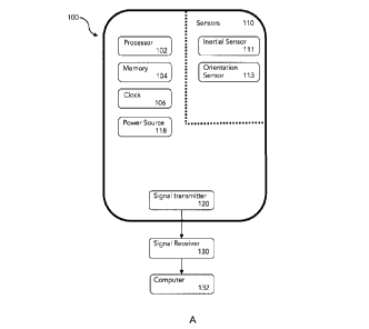
[0050] Figure 1A illustrates an example of a mobile device 100 configured
to collect
data for mapping an environment. To describe a travel path of a mobile device
in an
environment, the device movement is sensed and recorded in at least two
dimensions:
orientation of the mobile device at a time point, and scale of translation
between time points.
By measuring acceleration and/or velocity, changes in both orientation and
translation of the
travel path can be interpolated by identifying one or more path features along
the travel path.
Mobile device 100 comprises at least two sensors 110 capable of collecting
translation and
orientation information in order to track the movement of the mobile device
through space.
Inertial sensor 111 can measure both translation and orientation and can be
termed an
CA 3004246 2018-05-08
'interoceptive' sensor. The inertial sensor 111 also provides a measurement to
obtain a body
rate velocity. A single integration over time provides the change in location
relative to the
reference frame. To capture translation or linear acceleration or rotational
acceleration, a
double integration of acceleration of the inertial sensor provides a pose
delta which can be
understood to be a pose in the reference frame during the time that the
integration is over.
Linear acceleration inertial sensors such as accelerometers give an
acceleration in the (x,y,z)
frame. The orientation sensor 113 measures body rates in the local reference
frame, such as
rotational rate around the (x,y,z) axis. One common orientation sensor is a
gyroscope. A
gyroscope does not measure orientation directly, however can be used to
measure the change
in orientation over time. Taken together, a common form of a combination
inertial sensor and
orientation sensor is an inertial measurement unit (IMU).
[0051] The inertial and orientation sensors together provide
orientational and
translational measurements, and provide translation and orientation
information to construct
the travel trajectory of the mobile device through the environment. Preferably
the mobile
device also comprises at least one absolute locational or field sensor, also
referred to as an
exteroceptive sensor, capable of obtaining data on the environment external to
the mobile
device for additional localization information that can be used to further
refine the map.
Exteroceptive sensors are used for the observation of the environment or
objects around, for
example, the mobile electronic device. Some examples of exteroceptive sensors
include but
are not limited to magnetometers, sonar sensors, sound pressure sensors, light
sensors,
infrared (IR) sensitive sensors, ultrasonic distance sensors, radiofrequency
sensors,
thermometers, barometers, altimeters, and microphones. The information and
data provided
by an exteroceptive sensor in addition to path trajectory data extrapolated by
the combination
of pose data comprising the translation and orientation between poses can
enable more rapid
and/or more accurate generation of the travel path.
[0052] A translation or inertial sensor may not directly measure
translation, instead it
may measure signals that can be used to determine translation, e.g. double
integration of
11
CA 3004246 2018-05-08
acceleration over time or single integration of velocity over time to provide
a translation.
Similarly, the orientation sensor may not directly measure orientation,
however the outputs of
that sensor can be used to calculate an orientation or a change in
orientation. In particular, a
combination of inertial sensors to detect changes in rotational attributes
like pitch, roll and yaw
using one or more gyroscopes in combination with an accelerometer to detect
acceleration of
the mobile device and an exteroceptive orientation sensor such as, for
example, a
magnetometer, can provide sufficient data to track the movement of a mobile
device through
an environment.
[0053] In the example mobile device shown in Figure 1B, sensors 110
comprise a
gyroscope 112, accelerometer 114 and magnetometer 116. An accelerometer 114 is
an inertial
sensor that provides data to estimate distance traveled and 3-dimensional (3D)
acceleration
data in the frame of the mobile device as it travels through an environment.
The accelerometer
can be, for example, an angular accelerometer, linear accelerometer, or
combination thereof.
A gyroscope 112 is an inertial sensor that can be used for estimating changes
in orientation
and can provide 3D angular velocity in the frame of the mobile device. The
gyroscope may
either directly measure those orientations, or be a rate gyroscope which
measures the body
rates and can be used to calculate the orientation. An optional magnetometer
116 measures a
magnetic field external to the system and reports that as a vector in a local
sensor reference
frame. A combination of gyroscope and accelerometer measurements at a single
location
provide translational acceleration at a given moment while the localized
magnetic field vector
provides absolute orientation at the same location. Preferably the sensors are
combined as an
inertial measurement unit (IMU) comprising a combination of one more
accelerometer 114
and gyroscope 112, and optionally also a magnetometer 116.
[0054] The data obtained from the sensor combination can be used to
provide periodic
dead reckoning measurements as the mobile electronic device travels through a
space. By
combining of data from a clock 106 and sensor data, an estimate of how far and
in what
direction the mobile device has moved in the time period can be calculated. A
magnetometer
12
CA 3004246 2018-05-08
116 or compass can provide a 3-dimensional magnetic field measurement in the
frame of the
mobile device. A magnetic field reading by a compass or magnetometer can
provide an
absolute reference for some of the dimensions of the orientation dimension.
[0055] As an alternative to or in addition to a magnetometer, one or more
locational
beacon or anchor node may be also used to provide an absolute spatial location
of the device,
and can partially or completely constrain one or more dimensions in one, some
or all degrees
of freedom. An optional altimeter and/or barometer can provide altitude
measurements of the
mobile device relative to the earth surface. In a case of a facility with
multiple floors having a
similar layout, an altimeter can provide vertical location information to
differentiate the vertical
location of the device. In an environment with one or more anchor nodes, the
anchor node
may be emitting a radial signal on the ceiling of a lower floor and an
altimeter reading can
assist in differentiating location on lower or upper floors.
[0056] The mobile device can be a handheld device such as a smartphone,
tablet, or
portable computing device, or wearable device such as, for example, a fob,
watch, wristband,
jewelery, smart glasses, headsets, augmented reality or virtual reality
device, or smart clothing.
The mobile device can also be a mobile autonomous or semi-autonomous robot
capable of
moving through an environment. The mobile device comprises hardware such as a
clock 106,
memory 104, signal transmitter 120, battery or power system or power supply
118, and a
processor 102. Mobile device periodically collects local measurements obtained
from the IMU
or sensors 110 to obtain the measurements required to determine the travel
path. The memory
104 stores data collected from the sensors as the mobile device moves over a
plurality of
locations during a time period. The mobile device may also connect to a server
or computer
132 using a network through a signal transmitter 120 via, for example, a WiFi
or radio signal
and a signal receiver 130. The mobile device can also comprise a WiFi
transceiver, a
BluetoothTM receiver to measure BluetoothTM low-energy beacons, other wireless
receiver,
transmitter or transceiver, or a combination thereof.
13
CA 3004246 2018-05-08
[0057] The mobile device can also be enabled to communicate with the user
to provide
additional information to the user or enable the user to collect useful
information. An optional
output or alert means 108 enables messaging from the mobile device to a user,
for example to
draw the user's attention or to request additional information from the user
for the purpose of
map generation or localization. The alert means 108 can be a simple output
interaction
mechanism such as a light or vibration means, or can be more complex such as
screen with
visual output, or speaker, which can enable and promote interactive
localization, or
combination thereof. Human interaction alert features can serve multiple
purposes, such as
advising a user of where to go next, such as checking in at a landmark, or
requesting that a
user go to a particular place to build the map and/or to improve the quality
of the map, for
example to complete a loop closure. A user can also be requested to identify
where they are
on a map by interacting with a landmark or anchor node, and/or by inputting
information into
the mobile device via a screen, conversational interface, or scanner, which
can improve
localization and map generation. A request action from the mobile device could
be, for
example: go to nearest landmark, choose a location on a map via screen, take a
photo of the
area, return to a landmark or anchor node, turn in a circle, or request for
input information, for
example to input a code. In this way the mobile device can obtain additional
information to
locate itself in an environment by obtaining additional input from a person or
user which is
useful to verify its location in a known or unknown environment.
[0058] The mobile device can also be enabled to communicate with a
landmark or
anchor node in the environment via a transceiver. Optional input/output
sensors can also assist
in locating the device on a map with a known landmark. Non-limiting examples
of such sensors
include radio-frequency identification (RFID) scanners, NFC (near field
communication)
transceivers, speakers, ultrasonic speakers, camera, and light detectors. In
one example a
landmark or anchor node can ping a nearby mobile device and upon proximity of
the device to
the anchor node, locate the device relative to the anchor node. Further
coordination of the
mobile device with a SLAM system or geolocation map can be done via RFID and
radio signals.
14
CA 3004246 2018-05-08
In another example, a microphone on the mobile device can to listen to a tone
or pulse from a
nearby station emitting a tone, or the mobile device itself can emit a tone
for detection by a
nearby anchor node. A similar setup can be done using a signal either
transmitted or received
by the mobile device to/from an anchor node. In another example, a light
sensor on the mobile
device can pick up data emitted from a light source e.g. a pulse pattern from
a light emitting
diode (LED). Localization against the ceiling or ground using visual or
ennittive landmarks and a
corresponding camera or data capture means in the mobile device can also be
incorporated
into the localization. In an example, in a space that has planted landmarks or
visual features
such as a floor or ceiling image or map, a camera can spatially locate the
device by
triangulation relative to the stationary visual features. Other sensors can
also be used to
provide additional data at various states, such as proximity sensors or light
sensors to
determine, for example, the location of the mobile device on the moving
person, such as
exposed or in a pocket.
[0059] Map Generation
[0060] Figure 2A is a flowchart depicting an example method of
calculating a travel
path and creating a map for an unknown environment 200. First a travel
trajectory data set is
obtained for the travel path of the trackable or mobile device in an
environment 202. The travel
trajectory data set comprises dead reckoning data and can also comprise other
orientational or
other location data.The travel path is then calculated for the device 204
based on the dead
reckoning data set, which is converted into incremental dead reckoning deltas.
The travel path
comprises a sequence of incremental pose deltas taken together. Data from the
sensors may
undergo preprocessing at an internal processor in the mobile device.
Calculation of the travel
path can be done on the device, for example, by on board software on the
processor, by
extracting data from memory where sensor data has been stored and applying a
pre-defined
algorithm to estimate the travel path. In another alternative, sensor data
collected by the
device can be stored in the memory of the mobile device and transmitted or
downloaded to a
network or external system processor for calculation and travel path
determination. In one
CA 3004246 2018-05-08
example, a device such as watch can transmit data to a portable computation
device such as a
smartphone or computer where the map can be generated. In another example, if
the mobile
device collecting travel data is a smartphone, the data can be transmitted to
a network via WiFi
or cellular data connection and data can be processed by a receiving computer
to generate the
travel path of the mobile device in the environment. In another example,
travel data can be
processed in part on a processor in the mobile device and in part by an
external processor.
Creating a map of the environment with a mobile device can be done by one or
more internal
processors, external processors, or combination of internal processors and
external processors.
[0061] An extraction of one or more path features along the travel path
206 can be
done by calculating fragments of the travel path based on the travel
trajectory comprising a
string of dead reckoning deltas or sequence of poses, and stitching the poses
together to
arrive at a segment of the calculated travel path that defines the path
feature. The extracted
path features can be generalized within an acceptable margin of error such
that should the
same path feature be recognized as a pattern in a future dead reckoning data
set, path
features which have vector sections in common can be recognized. Once at least
one pair of
independently occurring path features has been identified, an overlay of the
extracted
complementary path features is done to constrain the map 208. By obtaining
multiple
complementary path features in a data set, such as when one device has
traveled along the
same path at least twice or when at least two devices have traveled along the
same path, the
accuracy of the map can be improved. As more data is obtained for each path
feature when
the travel path is traversed more times, the travel path gets flattened down
and the map
granularity improves.
[0062] A mapping module can be used to generate a local map comprising
local path
features. In particular, the mapping module builds a travel path on a map that
depicts the path
of travel of a mobile device through the environment and also delineates where
mobile devices
are found and not found in the area being mapped. In a preferred embodiment,
the
parameters being mapped by the mapping module include obstacles through which
there is
16
CA 3004246 2018-05-08
no travel, and clear spaces through which the mobile device is free to
navigate. By overlaying
the path features for the sections of the travel path which receive most and
least traffic, the
frequency of movement of particular devices through the environment can also
be monitored
and mapped.
[0063] In an industrial or commercial environment, frequent monitoring of
the building
environment can be important for security, efficiency or safety reasons. In
one example,
periodic security checks of areas of interest by a security guard in a
building can improve
general security monitoring of the building. In particular, if a security
guard is found not to be
regularly visiting a particular location in the building an alert can be
provided to the mobile
device advising the security guard to go to that area. In another example,
frequent monitoring
of industrial or factory environments by a factory floor supervisor is
correlated with increased
efficiency and safety on the factory floor. By tracking the travel path of a
work leader the
mobile device can provide an alert of where the work leader needs to visit
more or less
frequently.
[0064] In an environment with a fixed anchor node, proximity data to the
fixed anchor
node can also be collected by the mobile device along with the dead reckoning
measurements
collected by the inertial and locational sensors and used as an additional
degree of freedom
from which a map can be built. The known location of each of anchor node can
be stored in
the database to enhance or improve the map granularity. In another situation,
movable sensor
nodes, such as on industrial equipment, can also be tracked in relation to the
mapped travel
path and the locations of the sensor nodes can be updated to update the local
map. In this
situation, the locations of the sensor nodes within the mapped reference frame
can be
periodically updated to create a dynamic map of an environment. Additional
information such
as the footprint and configuration of the equipment corresponding to each
movable sensor
node can further enhance map generation by providing obstacle constraints in
the
environment based on the location and orientation of the movable industrial
equipment.
17
CA 3004246 2018-05-08
[0065] Conventional map data and collected mapping data may be stored in
a
database operated by a server. The server may comprise or be connected to a
computing
device capable of storing and maintaining map information and sending and
receiving map
information using the network. In some examples, the server may connect to an
external map
database operated by a third party in addition to storing mapping data
locally. The server may
be also be configured to store and maintain map information obtained from
public or
proprietary sources. The server may, for example, connect to Google Maps,
Google Earth, or
any other mapping service to obtain map information stored in those services
to tie features of
the travel path onto one or more existing maps and to geo-reference generated
maps.
[0066] Calculation of Travel Path
[0067] To calculate a travel path, measurements from an inertial sensor
and locational
sensor are converted into poses comprising incremental dead reckoning deltas,
where each
dead reckoning delta comprises the periodic dead reckoning measurements or
changes in
position and orientation by integrating over time, and each pose comprises
location data and
orientation data with an associated time stamp. An interpolation of data from
the incremental
dead reckoning deltas can provide a vector expression of path features which
can be later
identified upon successive travel on the same travel path.
[0068] The sequences of positions and orientations (also referred to as
"poses") can be
used to describe the movement of a moving device with respect to a frame of
reference. To
calculate a travel path in and map an unknown environment, dead reckoning
measurements
obtained by the mobile device are converted into incremental dead reckoning
deltas. In one
implementation the dead reckoning deltas can be used as the path features. In
another
implementation, the dead reckoning deltas can be used as part of the
calculation of the path
features and the calculation of travel path and path features can also
incorporate other data.
The calculation of the travel path does not have to be exclusively based on
dead reckoning
data and can also use other data to make a better estimate of the travel path.
In the simplest
18
CA 3004246 2018-05-08
case, the travel path and path features are based only on the dead reckoning
deltas. Reference
frames and transformations enable the localization of the mobile device in
space.
[0069] Figure 3 depicts a vector transformation between a fixed reference
frame and a
reference frame attached to a device or person. As shown in Figure 3, the
orientation of a
person or mobile device (also commonly referred to as a vehicle) can be
expressed in the
inertial, topocentric frame, wherein the x coordinate roughly points east, y
points to the
magnetic north, and z is opposite the acceleration due to gravity. Shown are
two reference
frames, land V. for the inertial frame and the vehicle frame, respectively. A
vector is a quantity
vi
having length and direction. Consider the vector that points to the vehicle
frame from the
inertial frame. This vector can be expressed in either of the reference frames
r =rjT F = FT ei
--->
vi
= rT v F = PT ri
v v
Fi
[0070] The quantity -) is referred to as a vectrix, and is a matrix that
can be thought
Fi
of as defining the axes of the inertial reference frame. The quantity will
be a 2x2 matrix
when formulating a problem in 2-dimensions, and will be a 3x3 matrix in a 3-
dimensional
Fv
formulation. Similarly, ¨) defines the axes for the vehicle frame. The
quantity rYi is a column
matrix containing the components of the vector to V from / expressed in frame
I. Similarly,
contains the components of -4 expressed in V. In general, rivi #
[0071] The rotation matrix, often referred to as a direction cosine
matrix, is defined as:
Cvi =: T111T
--- ---+
19
CA 3004246 2018-05-08
[0072] Rotation matrices possess some special properties. For example:
C21 = C-1-/ = C171.2
C31 = C32 C,1
ri
[0073] Consider a point p which can be written as a point in the vehicle
frame as pv. To
express the same point in the inertial frame, the transformation to frame V
from frame / (or
vice versa, because it is invertible) should be determined. One way to express
this
transformation is the homogeneous transformation; note the form of the
homogeneous vector
is Pv,h IPv T , =
With
Pi./7
[1i I [ pv
0 1
Pì = ¨
wherein:
a Symbols in this font are real scalars.
a Symbols in this font are real column vectors.
A Symbols in this font are real matrices.
(-)k The value of a quantity at timestep k.
The set of values of a quantity from timcstep k1 to timestep k2, inclusive.
(.)' The cross-product operator which produces a skew-symmetrix matrix
from a col
1 The identity matrix.
0 The zero matrix.
[0074] This calculation enables the expression of the point p in either
the inertial or the
vehicle reference frame. Given pv, which is the location of point p in the
vehicle frame, one can
calculate pi, which is the location of point p expressed in the inertial
frame. Doing this
calculation on a set of points in the vehicle frame and in different vehicle
frames, the location of
CA 3004246 2018-05-08
1
the point p in the inertial frame can be expressed. Each dead reckoning delta
can be
considered to be a transformation between two poses, and can also be
considered to be its
own pose for the purposes of path calculation.
[0075] Figure 4A is a pose graph of the movement of a mobile
device through an
environment. Nodes in the graph represent poses (A), or a location and
orientation of a mobile
device in an environment at a particular point in time. Edges (shown as arrows
between nodes)
are transformations between poses. The chain of poses along with timestamps
obtained by the
clock is a representation of the trajectory or travel path of a mobile device
through an
environment. Optional landmarks or anchor nodes (0) can be observed when pose
data is
collected from dead reckoning measurements. Landmarks can also be observed and
re-
observed to help identify when the mobile device returns to the same location.
A
determination of when the mobile device returns to the same location can be
determined by
overlaying the pose patterns comprising a series of feature vectors, to
identify corresponding
similar travel path features.
[0076] Figure 4B is a representation of a travel path feature
comprising multiple path
features. Given a travel path from waypoint A to waypoint D, the mobile device
extracts dead
reckoning measurements at periodic locations along the travel path with each
periodic
measurement comprising inertial sensor data, locational sensor data and clock
data. The
feature vector describing a section of the travel path comprises multiple
features, where each
feature identifies an aspect of the pose or the environment that can be
observed along the
travel path. In an example, the feature vector can include the translational
change in the local x
and y directions, the rotational change (A), beacon signal strength
(proximity), magnetic field
strength or vector, or other features. The set of features which makes up the
feature vector
allow the measurement of similarity between two feature vectors and can be
used in
determining whether those feature vectors represent the same path feature or
portion of a
travel path. Given a set of feature vectors which have been collected for a
particular travel
21
CA 3004246 2018-05-08
path, the set of feature vectors can be compared to second set of feature
vectors to determine
whether there is a similarity or common path feature along the travel path.
[0077] In the example shown in Figure 4B, at waypoint A the pose of the
mobile device
is collected. From waypoint A to waypoint B the mobile device travels a
distance a and collects
a plurality of feature vectors including incremental dead reckoning deltas. At
waypoint B there
is an orientation change and the mobile device begins traveling toward
waypoint C. After a
distance b the mobile device makes another orientation change at waypoint C
and travels
towards waypoint D for a distance d. The pose at each waypoint, orientation
and pose at
interstitial points along a straight path and distance between waypoints
creates a travel
fingerprint which can extracted from the travel path and identified as a
travel feature. The pose
at each waypoint and the distance between waypoints are feature descriptors
which contribute
to the overall identification of travel features along the travel path. The
next time the same or a
different mobile device travels along the same path, the feature vectors
including dead
reckoning measurements (within a reasonable margin of error) can be extracted
such that the
commonly travelled travel feature can be overlayed on top of the previously
identified travel
feature to create a travel map. In one example, a loop closure can be
accomplished by
identifying corresponding travel features to localize a device in an
environment and/or
determine that a mobile device is revisiting an already visited location. The
number of dead
reckoning measurements between waypoints can vary depending on the transit
time and/or
distance traveled.
[0078] Figure 5 is a graph of the three main reference frames: the
inertial frame, the
vehicle frame, and the sensor frame. A set of sensor measurements taken along
a travel path at
index k can be described as shown below. The movement of the frame of the
mobile device or
sensor frame is in 3-dimensions, however, the inertial frame and the sensor
frame are mostly 2-
dimensional. For this nonlinear problem the following motion and observation
models can be
used:
22
CA 3004246 2018-05-08
COS Ok_l ¨ Sill Ok_i 0 vk
motion: Y k = Y k-1 Tk_ I sin Ok_i COS Ok-i 0
0 + Wk
Ok Ok_I _ 0 0 1
observation: rkj = ¨ x02 + (yr 132 +
[0079] This motion model can be used to develop the method to build a
globally
consistent model of the travel paths. The motion model can be also used to
adjust the map
calculation and can also account for external data and noise. The observation
model is how
measurements can be taken from the environment to estimate a pose at index k,
taking into
account the estimate of position at k -1. Figure 6 is an example graph of
collected sensor data
over time, with yaw, filtered yaw and velocity data. The estimated state can
be propagated
based on the measurements and the motion model.
[0080] An example of a resulting calculated path based on the combination
of location
data and orientation data is shown in Figure 7. A long travel path is shown in
Figure 7, which
comprises extracted distinctive features, represented by dots (*). Each dot,
which is a location
of a distinctive feature vector and has a feature vector and a position of
where the dot is
estimated to be at. The distinctive features at each dots are compared against
the feature
vector at other dots to determine the similarity of the feature vectors at
various dot locations.
Two dots are determined to represent the same location on a map when the
similarity between
the two distinctive feature vectors is high. The map is then adjusted such
that the two dots will
lie on top of each other. In a map generation operation, a map can be built by
solving an
optimization for the travel path to relax the map. In a condition where an
attempt is being
made to match or locate a mobile device against an existing map, an attempt is
made to
match the distinctive feature vectors to identify where on the existing map
the path fragment
lies so that the mobile device can be located on the map. In some cases the
identified path
feature has a distinctive sequence of features, and the map is constrained by
matching the
location to a travel path already calculated for the environment which has a
high similarity or
match of feature vector to constrain the map. In other cases where the
identified path feature
23
CA 3004246 2018-05-08
has similarity to multiple already mapped path features, the path feature can
be matched to
multiple path feature matches and each of the multiple path feature matches
can be scored to
identify the best match. As additional data is collected on the travel
trajectory, the system can
narrow down the potential matches to a single best match.
[0081] To identify complementary travel features a Batch Gauss-Newton
Optimization
can be undertaken. In particular, the following discrete-time, time-invariant
motion and
observation models can be defined:
motion model: xk = h (xk_i , u, Wk)
observation model: yk = g (xo nk )
where k = 1 K is the discrete-time index and its maximum.
[0082] The noise variables wk and nk are generalized noise distributions.
Gaussian
distribution or other distribution may be assumed. The function h(-) is the
nonlinear motion
model and the function g(-) is the nonlinear observation model. The
interoceptive and
exteroceptive measurement errors can be defined to be:
ekifit (X) := Xk ¨ h(xk...Iuk , 0) ,
ei,,ext(x) := yk g (xk, 0)
[0083] A more compact way of writing the error can be defined as:
e1(x)
[ ek.int(x)
e4(x) := , e(x) := =
ek,exi(x)
eK (x)
[0084] Definitions of the Jacobians of the nonlinear motion and
observations models
are given by:
24
CA 3004246 2018-05-08
r dh(Xk Uk ,Wk H )h(xk_i,uk,wk
rlx,k =¨ w,k
ik-t,ukA) Ovv4
and
dg(xk,nk)
dg(Nk.nk) I
Gn.k
A = ¨
k Xk
[0085] So we can define
-11õ,1 1
- - -Gx.1
oxo
1
Oxt
ox := , H :=
OXK
-Gx.K
and
liw,1Q11117.17,1
Gn,iR 1 GnT ,1
1W21, Q 2 HwT,2
T := Gtt,2 R2 GttT,2
Hw,KQKHL,K
Gtt,KRKGK
[0086] The Gauss-Newton update is then given by:
CA 3004246 2018-05-08
(HTT- 1 H + AD) 6x* = -HTT-1 050.
[0087] Once the optimal update is computed, ax*, the actual update to the
design
parameter, X, is performed, according to:
i_+aSx*
where a E [OM is a user-definable parameter. Performing a line search for the
best value of
works well in practice. This works because ax* is a descent direction. In this
case adjusting for
the step direction has been found to be a bit more conservative towards
robustness rather than
speed. The term 5c- continues updating until Sx*is very small.
[0088] Mobile Device Localization in a Known Environment
[0089] The trajectory of a mobile computing device through an environment
can be
used to monitor the travel path of a mobile device user and localize a mobile
device on an
already known map. Monitoring trajectory or path of a person in an environment
can assist in,
for example, evaluating the performance of that person. The performance of a
person whose
responsibility it is to frequently monitor locations can be assessed based on
their movement
patterns in the environment. An example is a security guard who is tasked with
ensuring that an
indoor environment is monitored frequently. In another example in a
manufacturing
environment, the monitoring of the manufacturing floor is carried out by a
supervisor whose
responsibility it is to ensure proper supervision of a section of the factory.
Monitoring the
supervisor's travel path through the manufacturing floor environment can
identify locations of
frequent travel and locations of minimal travel. Areas of strength in terms of
monitoring can be
recognized, while also identifying the areas of their performance that could
be improved.
Tracking the movement of key individuals on a manufacturing floor provides
information about
where the individual travelled, and where they did not, and can provide
movement maps of
people in a local environment. Identifying where leaders spend their time and
don't spend
26
CA 3004246 2018-05-08
1
their time can help leaders to ensure they are paying attention to all parts
of their responsibility
domain, assists with escalation chain to identify the location of nearest and
available
maintenance person as required. Other examples of tracking of mobile devices
in an
environment may include tracking movement of a mobile device in a retail store
to determine
which locations in the retail store are more heavily and lightly traveled.
Other examples of
wider-ranging applications to this technology include but are not limited to
indoor or outdoor
games, device and traffic movement. A localization module in a mobile device
can be used to
determine the location of the mobile device traveling through an environment
that has already
been mapped by extracting the travel path of the mobile device and overlaying
it with
previously collected travel path data.
[0090]
Figure 8 is a flowchart depicting an example method of calculating a
travel path
and localization in an known environment 300. At first, a travel trajectory
data set is obtained
by the mobile device for travel of the trackable device in an environment 302.
The travel
trajectory data set comprises dead reckoning data and can also comprise other
orientational or
other location data. The environment may have been previously traveled by the
same or
different mobile device, and travel path features have already been identified
for the
environment. Once a sufficient distance has been traveled through the
environment, a travel
path is calculated for the movement of the device 304 comprising incremental
dead reckoning
delta vectors. Path features are then extracted from the travel path 306 as
described above. An
identification of familiar travel features can indicate whether a given
location, or a pose
associated with a node in a path/trajectory or pose graph, is the same as or
similar to one that
was previously visited. Once the travel path features of the travel path have
been identified, an
attempt is made to match the extracted travel path features to travel path
features on
previously created map 308. The system then inquires if the identified travel
feature matches
travel features previously identified 310. If the system finds a single match
then the system
returns the best match as an estimated pose of the device on a map 314. If the
system finds
multiple matches then each match can be scored to propagate multiple
hypotheses regarding
27
CA 3004246 2018-05-08
the location of the mobile device in the environment during time of
uncertainty. If a best match
is selected 312, then the best match is returned as a location on a map. One
way scoring may
be done is by a Mahalanobis distance calculation. If no match is found the
mobile device is
queued to obtain additional data 316 such that a match can be made in a
subsequent travel
path extraction. Additional data can be obtained from the mobile device via
additional sensor
readings, or by asking the user to take data, such as a photograph or light
reading, or by
requesting that the user identify their location on an existing map. Other
additional information
can be also be obtained, such as anchor node readings and visual landmarks
such as ceiling
and floor patterns to provide an additional dimension of data or additional
features to locate
the mobile device.
[0091] Figure 9 is a set of graphs of raw data obtained from a
magnetometer,
gyroscope and accelerometer in a mobile device. Shown are, from top to bottom,
linear
accelerations in the device's x,y,z coordinate frame, the angular rates around
the x,y,z axes of
the device's coordinate frame, and the magnetic field vector expressed in the
device's x,y,z
coordinate frame.
[0092] Mapping Including One or More Anchor Nodes
[0093] An anchor node can emit a signal to provide its spatial location
to a mobile
device in the environment to be mapped. A variety of signals can be used, such
as cellular
signals, BluetoothTM signals, and other wireless signals. In another example,
an anchor node
can receive a signal transmitted by the mobile device for localization. In an
environment with
three or more anchor nodes, a beacon signal map may also be constructed to
more precisely
locate the trackable device in the environment. In the field of
telecommunications, a received
signal strength indicator (RSSI) is a measurement of the strength of a
wireless signal.
Equipment on a manufacturing floor has a unique signature and can also be
mapped based on
the travel path of the mobile device as well as the known size and mapping
equipment. The
28
CA 3004246 2018-05-08
signature of the asset or equipment can also be triangulated, creating a
current map of the
factory floor, and compared with movement maps of people in a local
environment.
[0094] Figure 10 is a graph of the received signal strength from multiple
anchor nodes
in an environment. Identifying one or more anchor node signal strengths
reduces the search
space for a travel path matching in accordance with the present method.
[0095] Figure 11 is an additional example of an anchor node map with
multiple anchor
nodes. Graph A is a signal strength map where the signal strength is on a
logarithmic scale.
Graph B is a signal strength map with the signal strength on a linear scale.
Graph C is the
signal strength graph on a linear scale normalized by the total power
received. The anchor
node signals with the strongest relative strengths are prioritized. The result
is a locational
fingerprint that encodes the anchor nodes detectable at a given location.
Given a fingerprint of
anchor nodes and sensor readings by the mobile device, the possible set of
locations of the
mobile device can be narrowed down.
[0096] In a manufacturing environment, a map can be generated of the
plant floor
comprising the movement of mobile devices in the environment, optionally also
including
information from beacons regarding where particular assets are located. The
placement of
assets such as equipment on the manufacturing floor can further be optimized
based on
movement of individuals in the environment as well as the size and
requirements of the
manufacturing assets. A location of a mobile device in a manufacturing
environment can be
estimated according to a comparison of data available in the logs of data with
available known
signal strength maps of corresponding data. The first location estimates
indicate a trajectory of
the device over the time period. Second location estimates of the device
location using the
first location estimates and relative position estimates of the device based
on dead reckoning
can also be determined by one or more processors internal or external to the
mobile device.
Further travel paths of the mobile device along the same path provide a
refined trajectory of
the device over the time period. The mapping system may also receive wireless
signals from
29
CA 3004246 2018-05-08
wireless devices located in an area and create a wireless signal fingerprint
that identifies each
signal and the strength of the signal. In a beacon-dense environment with
three or more
beacons, a geo-referenced map can also be created to provide an absolute
location of a
trackable device. In an embodiment the mobile device has a wireless signal
receiver that is
configured to sense various wireless signals for use in determining a location
relative to a
beacon, or a location fingerprint. A location fingerprint may correspond to,
for example, a
wireless signal emitter and signal strength from that wireless signal emitter
providing an
indication of distance from the emitter.
[0097] Mapping of assets in a dynamic environment can also be done using
the present
method and system where the location of assets and physical features changes
overtime. In
dynamic environments comprising a plurality of movable assets, the travel path
calculated by
mobile devices in the environment can provide data regarding the placement of
movable
assets and when the assets were moved. When an asset comprises a beacons, the
combination
of the travel path and beacon signal can update the map of the local
environment further
utilizing the information known about the asset, such as footprint, to
identify the asset on a
map.
[0098] All publications, patents and patent applications mentioned in
this specification
are indicative of the level of skill of those skilled in the art to which this
invention pertains and
are herein incorporated by reference. The invention being thus described, it
will be obvious
that the same may be varied in many ways. Such variations are not to be
regarded as a
departure from the scope of the invention, and all such modifications as would
be obvious to
one skilled in the art are intended to be included within the scope of the
following claims.
CA 3004246 2018-05-08