Note: Descriptions are shown in the official language in which they were submitted.
- 1 -
FACILITY WAYFINDING SYSTEM
Technical Field
[0001] The present application relates to wayfinding and more specifically
to
wayfinding within a facility, i.e., facility wayfinding.
Background
[0002] Recent advancements in technology have transformed the ways in which
people orient themselves and navigate from place to place, i.e., wayfinding.
For
instance, technologies such as global positioning system (GPS)-enabled devices
and
map applications have made outdoor wayfinding more convenient and accurate.
[0003] However, fewer advancements have been made in technology relating to
wayfinding within a facility, i.e., facility wayfinding. Typically, static
physical signs and
directories are used for wayfinding within facilities. Such signs and
directories are
expensive to update and provide limited wayfinding information.
[0004] In attempts to improve facility wayfinding, some facilities have
developed
standalone mobile wayfinding applications. However, these mobile wayfinding
applications are, generally, facility-specific. Unfortunately, visitors to a
facility are often
reluctant to install a mobile wayfinding application useful for only that
facility on their
mobile devices, e.g., mobile phones. Furthermore, these mobile wayfinding
applications, generally, rely on signal-based localization of the mobile
device for routing.
Unfortunately, localization based on signals, e.g., GPS or WiFi signals, may
be
inaccurate or may require an additional localization system.
[0005] Other facilities have installed stand-alone interactive public
display
devices, i.e., digital directories. However, these interactive public display
devices are
fixed at a particular location within the facility. Once visitors leave that
location, they
must rely on their memory or, in some instances, a printout to recall
wayfinding
information provided by the interactive public display device.
[0006] A facility wayfinding system including both a mobile wayfinding
application
and an interactive public display device is disclosed in U.S. Patent
Application
CA 3009211 2018-06-22
- 2 -
Publication No. 2011/0022468 to Muster et al., published on January 27, 2011,
which is
incorporated herein by reference. The mobile wayfinding application, like
previous
stand-alone mobile wayfinding applications, relies on signal-based
localization of the
mobile device for routing. Furthermore, the interactive public display device,
like
previous interactive public display devices, relies on printouts to provide
visitors with a
record of wayfinding information. Therefore, an improved facility wayfinding
system is
desirable.
Summary
[0007] In accordance with a broad aspect, a wayfinding system for a
facility
including multiple facility units is described herein. The wayfinding system
includes a
facility device configured to: present a user interface on a display of the
facility device;
display a facility map showing facility units via the user interface; receive
a first location
and a second location from a mobile device; provide the first location and the
second
location to a backend system via the user interface, the second location
corresponding
to a facility unit of the facility units; and provide a uniform resource
locator (URL)
comprising an identifier associated with a route from the first location to
the second
location to the mobile device. The system also includes the mobile device
configured to:
present a mobile user interface on a display of the mobile device; provide the
first
location and the second location to the facility device; receive the URL
comprising the
identifier associated with the route from the facility device; via the URL,
provide the
identifier to the backend system; receive, from the backend system, the first
location
and the second location; update a start location to the first location and a
destination
location to the second location; display the facility map via the mobile user
interface;
and display the route from the start location to the destination location on
the facility
map via the mobile user interface.
[0008] In at least one embodiment, the facility is an indoor facility.
[0009] In at least one embodiment, the facility device is further
configured to
provide a promotional item relating to the facility unit to the mobile device
and the
mobile device is further configured to receive the promotional item from the
facility
device.
CA 3009211 2018-06-22
- 3 -
[0010] In at least one embodiment, the system also includes the backend
system,
wirelessly connected to the facility device and the mobile device, configured
to: provide
the facility map to the facility device and the mobile device; provide the
route from the
first location to the second location to the facility device; and provide the
route from the
start location to the destination location to the mobile device.
[0011] In at least one embodiment, the identifier uniquely identifies the
facility
device among multiple facility devices.
[0012] In at least one embodiment, the backend system is further
configured to
store identifiers, locations, and current selection states for the facility
device.
[0013] In at least one embodiment, the backend system is further
configured to
provide the first location and the second location to the mobile device upon
receipt of
the identifier.
[0014] In at least one embodiment, the backend system is further
configured to:
store identifiers, locations, and current selection states for the facility
device; and use
the identifier to identify the facility device and to retrieve the current
selection state for
the facility device, wherein the current selection state includes the first
location and the
second location.
[0015] In at least one embodiment, the wayfinding system further includes:
a
geographical information system (GIS), hosted internally by the backend system
or
supplied externally to the backend system, configured to store the facility
map and
associated facility metadata; and the destination location.
[0016] In at least one embodiment, the facility device is further
configured to
display a facility directory, listing the facility units, via the user
interface; wherein the
mobile device is further configured to display the facility directory, via the
mobile user
interface; and wherein the backend system is further configured to provide the
facility
directory to the facility device and the mobile device.
[0017] In at least one embodiment, the facility device is configured to
display the
facility map and the facility directory on a same screen of the user
interface; and
CA 3009211 2018-06-22
- 4 -
wherein the mobile device is configured to display the facility map and the
facility
directory on different screens of the mobile user interface.
[0018] In at least one embodiment, the display of the facility device is a
touch-
screen display; and wherein the facility device is configured to receive the
user selection
by detecting a user touch on a facility unit on the facility map or in the
facility directory.
[0019] In at least one embodiment, the facility device is configured to
provide the
first location and the second location to the backend system as a user
selection.
[0020] In at least one embodiment, the facility device is configured to
receive the
first location and the second location as a user selection.
[0021] In at least one embodiment, the backend system is configured to
provide
the first location and the second location to the mobile device upon receipt
of the
identifier.
[0022] In accordance with a broad aspect, a non-transitory computer-
readable
storage medium is described herein, the non-transitory computer-readable
storage
medium having stored thereon computer-executable instructions that, when
executed
by a processor of a mobile device, cause the processor of the mobile device to
execute
a mobile wayfinding application for integration into a wayfinding system for a
facility
including multiple facility units, the mobile wayfinding application causing
the mobile
device to: present a mobile user interface on a display of the mobile device;
display a
facility map, showing the facility units, via the mobile user interface;
display a route from
a start location to a destination location on the facility map, via the mobile
user interface;
receive a uniform resource locator (URL), the URL comprising an identifier
associated
with the route to obtain, from a backend system, a first location and a second
location,
wherein the mobile device is situated at the first location within the
facility, and the
second location comprises a location of a facility unit selected by a user of
the mobile
device; and update the start location to the first location and the
destination location to
the second location upon receiving the first location and the second location
from the
backend system.
CA 3009211 2018-06-22
- 5 -
[0023] In accordance with a broad aspect, a facility device for a facility
including
multiple facility units is described herein, the facility device configured
to: present a user
interface on a display of the facility device; display a facility map showing
facility units
via the user interface; receive a first location and a second location from a
mobile
device; provide the first location and the second location to a backend system
via the
user interface, the second location corresponding to a facility unit of the
facility units;
and provide a uniform resource locator (URL) comprising an identifier
associated with a
route from the first location to the second location to the mobile device.
[0024] In at least one embodiment, the facility device is wirelessly
connected to
the mobile device, wherein the mobile device is configured to: present a
mobile user
interface on a display of the mobile device; provide the first location and
the second
location to the facility device; receive the URL comprising the identifier
associated with
the route from the facility device; via the URL, provide the identifier to the
backend
system; receive, from the backend system, the first location and the second
location;
update a start location to the first location and a destination location to
the second
location; display the facility map via the mobile user interface; and display
the route from
the start location to the destination location on the facility map via the
mobile user
interface.
[0025] In at least one embodiment, the facility device is further
configured to
provide a promotional item relating to the facility unit via the mobile device
and the
mobile device is further configured to receive the promotional item from the
facility
device.
[0026] In at least one embodiment, the facility device is wirelessly
connected to
the backend system, and the backed system is configured to: provide the
facility map to
the facility device and the mobile device; provide the route from the first
location to the
second location to the facility device; and provide the route from the start
location to the
destination location to the mobile device.
[0027] Other aspects and features will become apparent, to those ordinarily
skilled in the art, upon review of the following description of some exemplary
embodiments.
CA 3009211 2018-06-22
- 6 -
Brief Description of the Drawings
[0028] The drawings included herewith are for illustrating various examples
of
articles, methods, and apparatuses of the present specification. In the
drawings:
[0029] FIG. 1 is a block diagram of an exemplary facility wayfinding
system, in
accordance with an embodiment;
[0030] FIG. 2 is a schematic illustration of an exemplary interactive
public display
device, in accordance with an embodiment;
[0031] FIG. 3 is a schematic illustration of a prior-art mobile device for
running a
mobile wayfinding application, in accordance with an embodiment;
[0032] FIG. 4 is flow diagram of an exemplary synchronization method, in
accordance with an embodiment;
[0033] FIG. 5 is a block diagram of an exemplary facility wayfinding
system, in
accordance with another embodiment; and
[0034] FIG. 6 is a flow diagram of an exemplary wayfinding method, in
accordance with another embodiment.
Detailed Description
[0035] Various apparatuses or processes will be described below to provide
an
example of each claimed embodiment. No embodiment described below limits any
claimed embodiment and any claimed embodiment may cover processes or
apparatuses that differ from those described below. The claimed embodiments
are not
limited to apparatuses or processes having all of the features of any one
apparatus or
process described below or to features common to multiple or all of the
apparatuses
described below.
[0036] The present specification provides wayfinding system for a facility
including multiple facility units, i.e., a facility wayfinding system. The
wayfinding system
is not restricted to a single facility, but may be extended to multiple
facilities of the same
type and/or different types, each including multiple facility units.
CA 3009211 2018-06-22
- 7 -
[0037] The wayfinding system allows users, e.g., visitors to the facility,
to orient
themselves and to navigate from place to place within the facility, enabling
them to find
what they are looking for and to discover things around them. For example, a
shopper
at a mall can use the wayfinding system to search for a particular store or a
particular
item, e.g., shoes, to navigate to the relevant location, and/or to look at the
current
promotions.
[0038] The facility may be any type of facility. Typically, the facility is
a
commercial facility or an institutional facility. For example, the facility
may be a retail
facility, e.g., a mall or a shopping center, an office facility, e.g., an
office building, an
event facility, e.g., a conference center or a theme park, a transportation
facility, e.g., an
airport, an educational facility, e.g., a school or a university campus, or a
medical
facility, e.g., a hospital. The facility may be an indoor or an outdoor
facility. However, the
wayfinding system is particularly useful for indoor facilities.
[0039] The facility units may be any type of facility units, and the
facility may
include different types of facility units. Typically, the facility units are
commonly
managed as part of the facility. For example the facility units may be stores,
restaurants,
booths, offices, rooms, halls, washrooms, airport gates, and/or locations or
areas within
the facility.
[0040] With reference to FIG. 1, an exemplary embodiment of the wayfinding
system 100 includes a variety of user-facing components 101 all supported by a
common backend system 102. Advantageously, by using a common backend system
102 for all the user-facing components 1 0 1, system speed is increased and
infrastructure costs are reduced. The user-facing components 101 and the
backend
system 102 are operatively connected, typically, via the Internet. The
individual
connections may be wired or wireless connections.
[0041] Preferably, the user-facing components 101 and the backend system
102
communicate asynchronously, for example, by using an implementation of the
WebSocket protocol, such as Socket.I0. Updates are, preferably, sent from the
backend system 102 to each of the user-facing components 101 in real time as
interrupts, i.e., without polling. Likewise, user interaction data is,
preferably, sent from
CA 3009211 2018-06-22
- 8 -
each of the user-facing components 101 to the backend system 102 in real time
as
interrupts, i.e., without polling.
[0042] The user-facing components 101 include an interactive public display
device 110, i.e., a digital directory, a mobile wayfinding application 120, a
content and
analytics dashboard 130, a non-interactive public display device 140, i.e., a
digital sign,
and a web wayfinding application 150. Although a single instance of each of
the user-
facing components 101 is illustrated in FIG. 1, the wayfinding system 100 may
include
multiple instances of each of the user-facing components 101. The backend
system 102
includes a content management system (CMS) 160, an analytics database system
170,
and a geographical information system (GIS) 180.
[0043] Note that other embodiments may omit some of these components or
systems and/or include additional components or systems. For example, the
wayfinding
systems 100, 500 are customizable for the type of facility. Also, different
types of
facilities have different needs, and the wayfinding systems 100, 500 may be
customized
to suit those needs. Each of the user-facing components 101 may be customized
in
terms of the appearance of the user interfaces and the types of information
displayed
via the user interfaces. For example, for a convention center, a consistent
color theme
may be selected for the user interfaces, and background information about
speakers
and/or seminar information may be displayed.
[0044] In general, the interactive public display device 110 and the non-
interactive public display device 140 each include a processor, memory, and a
network
interface card. These devices, specifically, the processors thereof, are
configured by
applications mentioned hereafter to execute the actions described hereafter.
In general,
the mobile wayfinding application 120, the content and analytics dashboard
130, the
CMS 160, the analytics database system 170, and the GIS 180 each run on
devices
including a processor, memory, and a network interface card, and thereby,
configure the
devices, specifically, the processors thereof, to execute the actions
described hereafter.
The applications are, generally, embodied in non-transitory computer-readable
storage
media, typically, device memories, and are executable by device processors.
CA 3009211 2018-06-22
- 9 -
[0045] The interactive public display device 110 is situated at a
particular location
within the facility. Typically, the interactive public display device 110 is
fixed or mounted
at the particular location. Preferably, the interactive public display device
110 is
provided with an identifier, e.g., a serial number, which uniquely identifies
the interactive
public display device 110 among multiple interactive public display devices
110 situated
at different locations within the same and/or different facilities.
[0046] The interactive public display device 110 may have a variety of
designs
depending on its location. For example, the interactive public display device
110 may
have a free-standing kiosk design or a wall-mounted design. In addition to a
processor,
memory, and a network interface card, the interactive public display device
110 includes
a display and, preferably, a synchronization feature.
[0047] The display of the interactive public display device 110 is a large-
screen
display adapted for public viewing. For example, the display may have a
diagonal
screen size of greater than 30" (76 em). Typically, the display is a touch-
screen display,
e.g., a capacitive touch-screen display. For example, the display may be a
liquid crystal
display (LCD) with an integrated or separate touch-sensing mechanism. In some
instances, the interactive public display device 110 may include a separate
input device,
e.g., a touchpad, one or more keys, and/or a keyboard, in addition to or
instead of a
touch-screen display.
[0048] The synchronization feature is, typically, an external, scannable,
i.e.,
machine-readable, feature. For example, the synchronization feature may be a
quick
response (QR) code or a near-field communication (NFC) tag. A OR code may be
printed on a sticker or other medium and attached to the interactive public
display
device 110, or may be printed or painted directly on the interactive public
display device
110. An NFC tag, which is, typically, made of a conductive material such as
copper,
may be embedded in a sticker or other medium and attached to the surface of
the
interactive public display device 110, or may be embedded directly into the
interactive
public display device 110. In some instances, the interactive public display
device 110
may include multiple synchronization features of different types. For example,
the
interactive public display device 110 may include both a QR code and an NFC
tag,
CA 3009211 2018-06-22
- 10 -
disposed separately from one another on the interactive public display device
110 or
disposed on top of one another on the interactive public display device 110.
[0049] The synchronization feature is configured to enable a mobile device,
running the mobile wayfinding application 120, to synchronize with the
interactive public
display device 110, typically, by scanning the synchronization feature.
Preferably, the
synchronization feature is encoded with the identifier of the interactive
public display
device 110.
[0050] For example, the identifier may be included in a unique uniform
resource
locator (URL) corresponding to the interactive public display device 110. In
one
embodiment, the mobile device can be synchronized with the interactive public
display
device 110 to load a state of the interactive public display device 110 to the
mobile
device by referencing the unique URL. When the interactive public display
device 110
is synchronized with the mobile device from within the operating system of the
mobile
device, e.g., by using a QR reader application or a built-in NFC reader, the
URL directs
to the appropriate download page for the mobile wayfinding application 120,
e.g., an
application or "app" store. When the interactive public display device 110 is
synchronized with the mobile wayfinding application 120 of the mobile device
from
within the mobile wayfinding application 120, e.g., by using an in-app
reader/scanner,
the mobile wayfinding application 120 loads the state of the interactive
public display
device 110 through the back end system 102 by referencing the unique URL.
[0051] In another embodiment, the mobile device can receive route
information
from a facility device 503 by referencing the unique URL (as described with
reference to
FIGs 5 and 6, below) In this embodiment, for example, a user of the mobile
device 501
can provide a destination location and a starting location to the facility
device 503 over a
communications network 504. In another example, a user of the mobile device
501 can
provide a destination location and a starting location to a user of the
facility device 503
(e.g. orally or using a wireless communication technology (e.g. SMS, etc.)).
In this
example, the user of the facility device 503 can input the destination
location and the
starting location into the facility device 503.
CA 3009211 2018-06-22
-11 -
[0052] Facility device 503 has a facility application 511 for
communication to a
backend system 502. Backend system 502 can determine a route from the starting
location to the destination location, link the route to the unique URL and
transmit the
unique URL to either or both of the facility device 503 or the mobile device
501. In the
embodiment where the backend system 502 transmits the unique URL directly to
the
mobile device 501, the facility device 503 can provide the backend system 502
with an
identifier of the mobile device 501 (e.g. phone number or the like) to use to
transmit the
unique URL to the mobile device 501. In the embodiment where the backend
system
502 transmits the unique URL to the facility device 503, either a user of the
facility
device 503 can transmit the unique URL to the mobile device 501 or the
facility device
503 can automatically transmit the unique URL to the mobile device 501 based
on, for
example, the starting location and the destination location.
[0053] With reference to FIG. 2, an exemplary embodiment of the
interactive
public display device 210 is designed as a free-standing kiosk. The
interactive public
display device 210 includes an enclosure 211, i.e., a housing, a touch-screen
display
212 supported by the enclosure 211, a synchronization feature 213 on the
enclosure
211, as well as a processor (not shown), memory (not shown), and a network
interface
card (not shown) within the enclosure 211. In the illustrated embodiment, the
touch-
screen display 212 has a substantially vertical orientation, which allows an
additional
display to be included on an opposite side of the interactive public display
device 210. In
other words, a non-interactive public display device may be integrated with
the
interactive public display device 210.
[0054] With reference again to FIG. 1, the interactive public display
device 110
runs a public wayfinding application, which may be a web application running
in a web
browser and hosted by the back end system 102 or a native application stored
in the
memory of the interactive public display device 110. The interactive public
display
device 110, running the public wayfinding application, presents a public user
interface,
which is adapted for simultaneous viewing by multiple users, on its display.
The
interactive public display device 110 displays information relating to the
facility and the
facility units, including wayfinding information, via the public user
interface, and receives
user requests for such information via the public user interface.
CA 3009211 2018-06-22
- 12 -
[0055] The wayfinding information that is displayed includes a facility
map 182
showing the facility units. The facility map 182 illustrates the layout of the
facility units
within the facility, facilitating navigation through the facility. The
wayfinding information
also includes routes from a start location to a destination location on the
facility map 182
and, optionally, corresponding directions. Typically, the wayfinding
information further
includes a facility directory listing the facility units. The facility
directory lists the facility
units by name in an organized manner, e.g., alphabetically, by category,
and/or by
location.
[0056] The representation of the wayfinding information in the public user
interface is optimized for public viewing. Typically, the whole facility map
182 or a
complete floor of the facility map 182, i.e., a floor map, is displayed on a
single screen
of the public user interface. When the facility has more than one floor, the
public user
interface may cycle through multiple floor maps over time. Preferably, a whole
facility
map 182 or floor map is always displayed, even while a user is interacting
with the
interactive public display device 110, so that other users may use the map for
navigation.
[0057] Typically, the whole facility directory or a complete category of
the facility
directory, i.e., a directory category, is displayed on the same screen of the
public user
interface. When the directory is organized by category, the public user
interface may
cycle through multiple directory categories over time. Preferably, a whole
facility
directory or directory category is always displayed, even while a user is
interacting with
the interactive public display device 110, so that other users may use the
directory for
navigation. Also preferably, the facility units are labeled with an identifier
on the facility
map 182 and listed with the same identifier in the facility directory.
[0058] In one embodiment, a user request for wayfinding information
involves a
user selection of a facility unit as a destination location, via the public
user interface of
the interactive public display device 110. Typically, the user selection of a
facility unit as
a destination location via the public user interface is received by detecting
a user touch
on a facility unit on the facility map 182, i.e., an interactive facility map
182, or in the
facility directory, i.e., an interactive facility directory, displayed on a
touch-screen
CA 3009211 2018-06-22
- 13 -
display. Alternatively, the user selection may be received from a separate
input device,
e.g., a touchpad, one or more keys, and/or a keyboard. The facility unit
selected as the
destination location is highlighted on the facility map 182, and a route from
the
interactive public display device 110, as the start location, to the facility
unit selected as
the destination location is displayed on the facility map 182.
[0059] Optionally, corresponding point-to-point directions may be
displayed along
with more detailed map views on the same screen of the public user interface.
Typically,
additional information relating to the facility unit selected as the
destination location is
also displayed, such as a profile, a photograph, directory information, e.g.,
a phone
number and/or an address, opening hours, event information, promotional
information,
e.g., an advertisement and/or a marketing message, and/or a promotional item,
e.g., a
digital coupon.
[0060] In some instances, a user selection of a directory category may
also be
received. Typically, the user selection of a directory category is received by
detecting a
user touch on a heading of the facility directory. Alternatively, the user
selection may be
received from a separate input device, e.g., a touchpad, one or more keys,
and/or a
keyboard. When a directory category is selected, those facility units
categorized as
belonging to that directory category are displayed. For example, a user may
select the
directory category "shoes", and those facility units categorized as shoe
stores may be
displayed.
[0061] Accordingly, the public user interface has a selection state
including a
user selection of a destination location and, in some instances, a user
selection of a
directory category. Preferably, the public user interface has a selection
state including at
most two user selections, i.e., at most two layers of statefulness relating to
user
selections.
[0062] The interactive public display device 110 may also display real-
time
notifications, e.g., notifications of events, notifications of promotions,
and/or alerts.
[0063] The non-interactive public display device 140 is physically similar
to the
interactive public display device 110, but lacks user interactivity. In
general, the non-
interactive public display device 140 includes a non-touch display, e.g., a
standard LCD
CA 3009211 2018-06-22
- 14 -
display. The non- interactive public display device 140 may be installed as a
free-
standing unit or may be integrated with the interactive public display device
110. For
example, a non-interactive public display device 140 may be integrated with
the
interactive public display device 210 of FIG. 2, sharing the same enclosure
211,
processor, memory, and network interface card. The noninteractive public
display
device 140 displays wayfinding and/or promotional information, typically, a
static facility
map 182, a static facility directory, and/or an advertisement.
[0064] Like the interactive public display device 110, preferably, the non-
interactive public display device 140 is provided with an identifier which
uniquely
identifies the interactive public display device 140, and includes a
synchronization
feature encoded with the identifier, e.g., a QR code or an NEC tag referencing
the
physical location of the non-interactive public display device 140.
[0065] The mobile wayfinding application 120 runs on a mobile device,
which is a
hand-held, portable computer device, such as a mobile phone, e.g., a
smartphone, a
personal digital assistant (PDA), or a tablet computer. In addition to a
processor,
memory, and a network interface card, the mobile device includes a display
and,
preferably, also includes a synchronization device.
[0066] The display of the mobile device is a small-screen display adapted
for
personal v1 ewmg. For example, the display may have a diagonal screen size of
less
than 15" (38 cm). Typically, the display is a touch-screen display. In some
instances, the
mobile device may include a separate input device, e.g., a touchpad, one or
more keys,
and/or a keyboard, in addition to or instead of a touch-screen display.
[0067] Typically, the synchronization device is a scanning, i.e., reading,
device,
and the mobile device is configured to scan the synchronization feature, in
order to read
the synchronization feature. For example, the synchronization device may be a
camera,
an NFC transceiver, a Bluetooth transceiver, or a WiFi transceiver. In some
instances,
the mobile device may include multiple synchronization devices of different
types. For
example, the mobile device may include both a camera and an NEC transceiver.
[0068] With reference to FIG. 3, an exemplary embodiment of the mobile
device
320 is a conventional smartphone. The mobile device 320 includes a housing
321, a
CA 3009211 2018-06-22
- 15 -
touch-screen display 322 supported by the housing 321, and a home key 323 on
the
housing 321, as well as a processor (not shown), memory (not shown), a network
interface card (not shown), and a synchronization device 324, e.g., an NFC
transceiver,
within the housing 321.
[0069] With reference again to FIG. 1, the mobile wayfinding application
120 is,
typically, a native application stored in the memory of the mobile device and
running in
the operating system of the mobile device. In general, different versions of
the mobile
wayfinding application 120 are written for different mobile platforms, in the
appropriate
languages, using the appropriate software development kits (SDKs) and
frameworks.
[0070] The mobile device, running the mobile wayfinding application 120,
presents a mobile user interface, which is adapted for viewing by a single
user, on its
display. The mobile user interface and the public user interface have similar
appearances, functions, and features, so that users are able to easily
transition between
the user interfaces. The mobile device displays information relating to the
facility and
the facility units, including wayfinding information, via the mobile user
interface, and
receives user requests for such information via the mobile user interface.
[0071] The wayfinding information that is displayed via the mobile user
interface
on the mobile device is, generally, the same as that displayed via the public
user
interface on the interactive public display device 110, but the representation
of the
wayfinding information in the mobile user interface is optimized for personal
viewing on
a small-screen display, rather than public viewing on a large-screen display.
The mobile
user interface offers additional content, and additional levels of screens,
menus, and
interactions.
[0072] Typically, a list of multiple facilities is displayed on an initial
screen of the
mobile user interface. A user selection of a facility is received by detecting
a user touch
on a touchscreen display or from a separate input device. A facility map 182,
a facility
directory, and facility events associated with the selected facility may then
be accessed.
[0073] Typically, the facility map 182 or a portion thereof is displayed on
a single
screen of the mobile user interface, and the facility map 182 may be
manipulated
through finger gestures. For example, the facility map 182 may be moved by a
single-
CA 3009211 2018-06-22
- 16 -
finger gesture, or magnified or reduced by a two-finger gesture. Preferably,
the facility
units are displayed with markers, which allow a user selection of a facility
unit to be
made by a single-tap gesture on the corresponding marker. Typically, the
facility
directory or a portion thereof is displayed on a different screen of the
mobile user
interface, and the facility directory may be manipulated through finger
gestures. For
example, the facility directory may be scrolled by a single-finger gesture.
[0074] A user request for wayfinding information involves a user selection
of a
facility unit as a destination location, via the mobile user interface.
Typically, the user
selection of a facility unit as a destination location is received by
detecting a user touch
on a facility unit on the facility map 182 or in the facility directory
displayed on a touch-
screen display. Alternatively, the user selection may be received from a
separate input
device, e.g., a touchpad, one or more keys, and/or a keyboard. The facility
unit selected
as the destination location is highlighted on the facility map 182.
[0075] Typically, additional information relating to the facility unit
selected as the
destination location is also displayed, such as a profile, a link to a webpage
or a social
media page, a photograph, directory information, e.g., a phone number and/or
an
address, opening hours, event information, promotional information, e.g., an
advertisement and/or a marketing message, and/or a promotional item, e.g., a
digital
coupon. Additionally, information generated by other people, e.g., friends on
social
media sites, or friends from within the mobile wayfinding application 120, may
be
displayed in the mobile user interface. Preferably, each facility unit has its
own profile
page where the additional information may be accessed.
[0076] For routing to the facility unit selected as the destination
location without
synchronizing the mobile device, a user selection of a facility unit as a
start location is
also received, via the mobile user interface. Typically, the user selection of
a facility unit
as a start location is received by detecting a user touch on a facility unit
in the facility
directory displayed on a touch-screen display or by searching for an
alphanumeric
string, e.g., by using a real-time intelligent search, input from an on-screen
or physical
keyboard. A route from the facility unit selected as the start location to the
facility unit
selected as the destination location is then displayed on the facility map
182. Optionally,
CA 3009211 2018-06-22
- 17 -
corresponding point-to-point directions may also be displayed. For example,
the point-
to-point directions may accessed by sliding between points on a progress bar
displayed
below the facility map 182. As each point is reached, a corresponding step is
illustrated
on the facility map 182 and also displayed as text.
[0077] Preferably, the wayfinding system 100 allows a user to synchronize
or
"sync" their mobile device, running the mobile wayfinding application 120,
with the
interactive public display device 110. For example, a user may use a
synchronization
device on their mobile phone to interface with a synchronization feature on
the
interactive public display device 110. Preferably, the mobile wayfinding
application 120
includes an in-app reader/scanner.
[0078] Upon synchronization, the start location is updated to the
interactive public
display device 110, and the destination location is updated to a facility unit
selected on
the interactive public display device 110. In general, the selection state of
the mobile
wayfinding application 120 is updated to the selection state of the
interactive public
display device 110. In other words, the mobile wayfinding application 120
reflects what
is displayed and selected on the interactive public display device 110. Thus,
advantageously, the mobile wayfinding application 120 does not have to rely on
signal-
based localization of the mobile device for routing and does not have to rely
on printouts
to provide a record of wayfinding information. For example, if a shopper at a
mall uses
the interactive public display device 110 to select a particular store, and to
obtain a
route to the store and other relevant information about the store, the shopper
can
synchronize their mobile phone with the interactive public display device 110
to load the
same route and information into the mobile wayfinding application 120.
Optionally, upon
synchronization, the mobile device may also receive a promotional item, e.g.,
a digital
coupon, displayed on the interactive public display device 110.
[0079] In some instances, the mobile device, running the mobile wayfinding
application 120, may be synchronized with the non-interactive public display
device 140
in a similar manner to update the start location to the non-interactive public
display
device 140.
CA 3009211 2018-06-22
- 18 -
[0080] With reference to FIG. 4, in an exemplary embodiment of a
synchronization method 400, a mobile device scans a scannable synchronization
feature on an interactive public display device, by means of a scanning
device, in a first
step 401. The interactive public display device is located at a first location
within a
facility and has been used to select a facility unit as a second location,
i.e., has a
current selection state including a user selection of the second location.
Accordingly, the
interactive public display device displays a route from the first location to
the second
location, via the public user interface. In a second step 402, the mobile
device receives
a unique URL including an identifier of the interactive public display device.
[0081] If the mobile device already has the mobile wayfinding application
installed, the mobile device provides the identifier to the backend system,
via the URL,
in a third step 403. In return, the mobile device receives the first location
and the second
location from the backend system, in a fourth step 404. In a fifth step 405,
the mobile
device updates its start location to the first location and its destination
location to the
second location in the mobile wayfinding application. Accordingly, the mobile
device
displays the route from the first location to the second location, via the
mobile user
interface, in a sixth step 406.
[0082] If the mobile device does not have the mobile wayfinding
application 120
installed, the URL directs the mobile device to download the mobile wayfinding
application 120 from an application store, in an alternative step 407.
[0083] The mobile device may also display real-time notifications, e.g.,
notifications of events, notifications of promotions, and/or alerts.
[0084] With reference again to FIG. 1, the web wayfinding application 150
runs in
a web browser on a computer device, e.g., a desktop computer or laptop
computer, and
is hosted by the backend system 102. The web wayfinding application 150 is,
generally,
similar to the mobile wayfinding application 120, but is designed for a
standard
computer device, rather than a mobile device. Accordingly, the representation
of the
wayfinding information is optimized for personal viewing on a standard-screen
non-
touch display. User selections are received from an input device, e.g., a
mouse or a
keyboard.
CA 3009211 2018-06-22
- 19 -
[0085] The content and analytics dashboard 130 is, typically, a web
application
running in a web browser on a computer device, e.g., a desktop computer or
laptop
computer, and hosted by the backend system 102. The content and analytics
dashboard 130 is a management application, which allows authorized users,
e.g.,
facility managers, to manage and administer the wayfinding system 100.
Advantageously, by using the content and analytics dashboard 130, authorized
users
are able to manage and administer all of the user-facing components 101 in one
place
and at the same time.
[0086] The content and analytics dashboard 130 includes a content module,
which enables authorized users to update content stored in the CMS 160 in the
backend system 102. Information relating to the facility and the facility
units can easily
be accessed and changed, e.g., revised, added, or removed. Updates are pushed
to the
interactive public display device 110, the mobile wayfinding application 120,
and the
web wayfinding application 150 in real time. For example, a hospital
administrator may
use the content and analytics dashboard 130 to update contact information for
a
hospital department on all interactive public display devices 110 situated
within the
hospital and on all versions of the mobile wayfinding application 120.
[0087] The content and analytics dashboard 130 also includes an analytics
module, which enables authorized users to receive and view analytics from the
analytics
database system 170 in the backend system 102. Analytics relating to user
interactions
with the interactive public display device 110, the mobile wayfinding
application 120,
and the web wayfinding application 150, e.g., user selections or "hits",
searches, dates,
types of mobile device, and/or movement patterns represented as heat maps, may
be
accessed and viewed in real time. In particular, heat maps may be generated
manually
within the analytics database system 170 or by the GIS 180, by plotting
individual paths
taken by each user and overlaying color values onto the plot based on the
number of
overlayed paths.
[0088] Typically, the analytics describe and compare user interactions by
facility
unit, e.g., hits per facility unit, or by directory category, e.g., hits per
category, over a
particular time period, e.g., in tables, charts, and/or graphs. The analytics
may be
CA 3009211 2018-06-22
- 20 -
received in the form of a report, e.g., a monthly report or an on-demand
report. For
example, a hospital administrator may use the content and analytics dashboard
130 to
view heat maps of visitor/patient movement. For another example, a mall
manager may
use the content and analytics dashboard 130 to query how many shoppers
selected a
particular store or searched for washrooms by using a particular type of
mobile device
over a particular time period.
[0089] The backend system 102, typically, includes multiple backend
devices,
e.g., servers. Typically, the backend system 102 includes at least a database
server
and a hosting server. In some instances, the backend system 102 also includes
a
content distribution network (CDN). The CMS 160 and the analytics database
system
170 are hosted by the backend system 102. The GIS 180 may be hosted internally
by
the backend system 102 or supplied externally.
[0090] The CMS 160 is a database application, typically, implemented as a
web
service. The CMS 160 stores content, including information relating to the
facility and
the facility units, handles updates to the content received from the content
and analytics
dashboard 130, and provides the content to the interactive public display
device 110,
the mobile wayfinding application 120, and the web wayfinding application 150.
For
example, the CMS 160 may be a no structured query language (NoSQL) database
application. The content stored in the CMS 160 is customizable for the type of
facility.
Typically, the information stored for each facility unit includes a profile, a
link to a
webpage and/or link to a social media page, a photograph, directory
information, e.g., a
phone number and/or an address, opening hours, event information, promotional
information, e.g., an advertisement and/or a marketing message, and/or a
promotional
item, e.g., a digital coupon. Often, the information relating to the facility
and the facility
units is tied to a related entry in the facility metadata 183 stored in the
GIS 180. This
allows larger, less frequently accessed files to be stored in the CMS 160,
rather than the
GIS 180.
[0091] The CMS 160 also stores the identifier of the interactive public
display
device 110 together with the location of the interactive public display device
110, and
the current selection state of the interactive public display device 110.
Typically, the
CA 3009211 2018-06-22
- 21 -
CMS 160 stores identifiers, locations, and current selection states for
multiple
interactive public display devices 110. In some instances, the CMS 160 also
stores
identifiers and locations for multiple non-interactive public display devices
140.
[0092] When a mobile device, running the mobile wayfinding application 120,
sends an identifier of an interactive public display device 110 to the back
end system
102 upon synchronization with that interactive public display device 110, the
identifier is
received by the CMS 160. The CMS 160 uses the identifier to identify the
interactive
public display device 110, typically, among the multiple interactive public
display
devices, and to retrieve the location and the current selection state for the
interactive
public display device 110. The CMS 160 then provides the location and the
current
selection state of the interactive public display device 110 to the mobile
device, which
updates its location and selection state accordingly. Typically, the selection
state
includes a user selection of a destination location.
[0093] The analytics database system 170 is also a database application,
typically, implemented as a web service. The analytics database system 170
stores all
user interactions with the interactive public display device 110, the mobile
wayfinding
application 120, and the web wayfinding application 150, e.g., user selections
or "hits",
searches, dates, types of mobile device, and/or movement patterns represented
as heat
maps, in real time, and generates analytics relating to the user interactions.
Advantageously, because user interactions are recorded for several different
user-
facing components 101, a relatively large sample size is obtained. Typically,
user
interactions are stored in a raw format and preset metrics are passively
generated. For
example, all hits on the interactive public display device 110 and the mobile
wayfinding
application 120 at a mall may be recorded, and a table listing the number of
hits per
store in the current month may be generated, for viewing in the content and
analytics
dashboard 130.
[0094] The GIS 180 is, typically, a representational state transfer (REST)-
ful
application programming interface (API). The GIS 180 includes routing
algorithms 181,
facility maps 182, and associated facility metadata 183. The GIS 180 stores
the facility
maps 182 and the facility metadata 183, handles updates to the facility maps
182 and
CA 3009211 2018-06-22
- 22 -
the facility metadata 183, and provides the facility maps 182 and the facility
metadata
183 to the interactive public display device 110, the mobile wayfinding
application 120,
and the web wayfinding application 150. Typically, the GIS 180 serves the
facility maps
182, e.g., as PNG files, and the facility metadata 183, e.g., as JSON/XML
files, over the
web. The facility metadata 183 is customizable for the type of facility, and
may include
digital representations of paths, polygons encapsulating facility units, nodes
corresponding to facility locations, identifiers for each facility unit, and
qualitative
metadata 183, such as the type of path, e.g., hallway or dirt trail.
[0095] The GIS 180 also uses the routing algorithms 181 to calculate
routes and
provides the routes to the interactive public display device 110, the mobile
wayfinding
application 120, and the web wayfinding application 150. Typically, the
routing
calculations output a JSON/XML list of node or polygon identifiers
representing a
complete path, which the interactive public display device 110, the mobile
wayfinding
application 120, and the web wayfinding application 150 will interpret and
display. The
output may also include points of interest and other metadata 183, such as
total
estimated travel time based on type of path and real-time traffic.
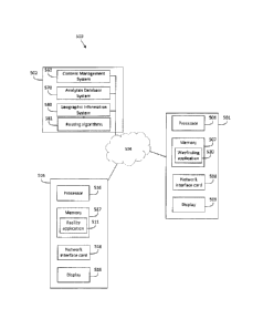
[0096] With reference to FIG. 5, an exemplary embodiment of the wayfinding
system 500 is shown. Wayfinding system 500 includes mobile device 501 and
facility
device 503, supported by a common backend system 502. Mobile device 501,
facility
device 503 and backend system 502 are operatively connected via network 504,
(e.g.
the Internet). It should be noted that there can be more than one mobile
device 501
and/or more than one facility device 503 operatively connected at a time
within system
500. The individual connections may be wired or wireless connections.
[0097] In the system 500, mobile device 501, facility devices 503 and
backend
system 502 may communicate asynchronously, for example, by using an
implementation of the WebSocket protocol, such as Socket.I0. In this example,
updates
may be sent from the backend system 502 to each of mobile device 501 and
facility
devices503 in real-time as interrupts, i.e., without polling. Likewise, user
interaction data
may, preferably, be sent from each of the mobile devices 501and the facility
device 503
to the backend system 502 in real-time as interrupts, i.e., without polling.
Mobile device
CA 3009211 2018-06-22
- 23 -
501 may also communicate with the facility devices 503 over network 504 (e.g.
Wi-Fi,
BluetoothTM, etc.)
[0098] Mobile device 501 is generally a hand-held, portable computer
device
such as a mobile phone (e.g., a smartphone, a personal digital assistant
(PDA), or a
tablet computer). In addition to a processor 506, memory 507, and a network
interface
card 508, the mobile device 501 includes a display 509. Display 509 is adapted
for
personal viewing. For example, the display 509 may have a diagonal screen size
of less
than 15" (38 cm). Typically, display 509 is a touch-screen display. In some
instances,
the mobile device 501 may include a separate input device, e.g., a touchpad,
one or
more keys, and/or a keyboard, in addition to or instead of a touch-screen
display.
[0099] Mobile device 501 may be a conventional smartphone (as shown in
FIG. 3
and described above). In one embodiment, mobile device 501 has wayfinding
application 520 as a native application stored in the memory 507 of mobile
device 501
and running in the operating system of the mobile device 501. In general,
different
versions of the mobile wayfinding application 520 are written for different
mobile
platforms, in the appropriate languages, using the appropriate software
development
kits (SDKs) and frameworks.
[0100] Mobile device 501, running the mobile wayfinding application 520,
presents a mobile user interface (not shown), which is adapted for viewing by
a single
user, on display 509. The mobile user interface displays information relating
to the
facility and the facility units, including wayfinding information, and can
receive user
requests for such information via the mobile user interface.
[0101] Backend system 502 includes a content management system (CMS) 560,
an analytics database system 570, and a geographical information system (GIS)
580.
[0102] Facility device 503 hosts a facility application 511. In general,
facility
device 503 includes a processor 516, memory 517, a network interface card 518
and a
display 519. Facility device 503, specifically the processor 516 thereof, is
configured by
facility application 511 to execute the actions described hereafter. Facility
application
511 is generally embodied in non-transitory computer-readable storage media
and/or
device memories and is executable by processor 516.
CA 3009211 2018-06-22
- 24 -
[0103] Facility device 503 can be situated within the facility or can be
situated
outside of the facility. Typically, facility device 503 is provided with an
identifier, e.g., a
serial number, which uniquely identifies the facility device 503 among
multiple facility
devices 503.
[0104] Facility device 503 can receive a user request for wayfinding
information
including a start location and a destination location from mobile device 501.
In one
embodiment, a user request for wayfinding information involves a user of
mobile device
501 providing a facility unit as a destination location to facility
application 511 of facility
device 503 as text information (e.g. via a text message, SMS message,
electronic mail
or the like) or audio information (e.g. as oral communication) via the mobile
device 501
either directly or through a user of the facility device 503. Typically, in
this embodiment,
the user of mobile device 501 also provides the starting location as text
information or
as audio information to the facility device 503 directly or to a user of
facility application
511 of facility device 503. Alternatively, the starting location can also be
provided to
facility application 511 of facility device 503 as GPS co-ordinates from the
wayfinding
application 520 by the mobile device (e.g. the co-ordinates received from a
receiver of
the mobile device). The user of mobile device 501 can provide the destination
location
and the start location electronically as text information (e.g. Email, SMS,
etc.) through
wayfinding application 520 or through any other application that can provide
transmission of text and/or audio information.
[0105] In another embodiment, the user request for wayfinding information
involves a user of mobile device 501 providing a facility unit as a
destination location to
facility device 503 through wayfinding application 520. In this embodiment,
the user of
mobile device 501 can also provide a start location of mobile device 501 (e.g.
using a
GPS of mobile device 501) to facility device 503. The user of mobile device
501 can
input the destination location and, optionally, the start location into mobile
wayfinding
application 520 directly and wayfinding application 520 can transmit the
destination
location and the start location to facility application 511 of facility device
503
automatically.
CA 3009211 2018-06-22
- 25 -
[0106] Once the start location and the destination location are received by
facility
application 511, facility application 511 provides the start location and the
destination
location to backend system 502. GIS 580 of backend system 502 uses routing
algorithms 581 to calculate a route or routes between the starting location
and the
destination location. Backend system 502 then provides the route(s) to at
least one of
facility device 503 and/or mobile device 501 (e.g. to facility application 511
and/or
wayfinding application 520, respectively). In some embodiments, backend system
502
can provide the route(s) to at least one of facility device 503 and/or mobile
device 501
for viewing in a third party application (e.g. in a browser application) or
can provide
instructions for at least one of facility device 503 and/or mobile device 501
to retrieve
the route(s) from backend system 502 using a third party application (e.g. .
in a browser
application). As described above, typically the routing calculations output a
JSON/XML
list of node or polygon identifiers representing a complete path, which the
facility
application 511 of facility device 503 and/or the mobile wayfinding
application 520 of
mobile device 501 will interpret and display. The output may also include
points of
interest and other metadata such as total estimated travel time based on type
of path
and real-time traffic.
[0107] Once received by the wayfinding application 520 of mobile device 501
(either directly from the backend system 502 or through the facility
application 511 of
facility device 503), the start location and the destination location on the
wayfinding
application 520 can be updated to a facility unit (e.g. as selected on
facility device 503
and provided to backend system 502).
[0108] In general, the selection state of the wayfinding application 520
can be
updated to the selection state of the facility application 511 on facility
device 503
through receipt and activation of a URL over wireless network 504 from backend
system
502, either directly or through facility device 503. Upon receipt at mobile
device 501, a
user of mobile device 501 can activate the unique URL, view the routing
information and
reflect on what facility units are selected and displayed on the mobile device
501. Thus,
advantageously, the mobile wayfinding application 520 does not have to rely on
signal-
based localization of the mobile device 501 for routing and does not have to
rely on
printouts to provide a record of wayfinding information.
CA 3009211 2018-06-22
- 26 -
[0109] In one example embodiment, if a shopper at a mall desires to obtain
a
route to a store and other relevant information about the store, the shopper
can use a
mobile device 501 to contact facility device 503 (e.g. using either wayfinding
application
520 or another communication mechanism (e.g. text message) as described above)
to
provide the facility device 503 with the current location (e.g. a start
location) of the
mobile device 501 and a destination location. The facility device 503 can
forward the
start location and the destination location to backend system 502 for the
backend
system 502 to determine a route or routes between the current location and the
destination location. The backend system 502 can then provide the facility
application
511 or the wayfinding application 520 with a URL for accessing the route(s).
[0110] Optionally, upon receiving the URL, the mobile device 501 may also
receive a promotional item, e.g., a digital coupon, associated with the store
(e.g. facility
unit) at the destination location or another store (e.g. facility unit).
[0111] With reference to FIG. 6, in an exemplary embodiment of a method
600, a
user of a mobile device 501 provides a starting location and a destination
location to
facility device 503 (e.g. to a user of facility device 503 or directly to
facility device 503),
in a first step 601. A user of facility device 503 may select a facility unit
(e.g. via a user
interface showing the facility and facility units) as a second location based
on the
destination location provided such that facility device 503 has a selection
state including
a first location and a second location. The facility device can forward the
first location
and the second location to backend system 502 which determines route
information
(e.g. a route from the first location to the second location) and sends the
route
information to the facility device 503 for display on the facility device 503.
The backend
system also generates a unique URL linked to the route information and
transmits the
unique URL for receipt by the mobile device 501 (either directly from the
backend
system 502 or through facility device 503).
[0112] If the mobile device 501 already has the mobile wayfinding
application 520
installed, the mobile device 501 provides the identifier to the backend system
502, via
the URL, in a step 603. In return, the mobile device 501 receives the first
location and
the second location from the backend system 502, in a step 604. In a step 605,
the
CA 3009211 2018-06-22
- 27 -
mobile device 501 updates its start location to the first location and its
destination
location to the second location in the mobile wayfinding application 520.
Accordingly,
the mobile device 501 displays the route from the first location to the second
location,
using the wayfinding application 520, via the mobile user interface in a sixth
step 606.
[0113] If the mobile device does not have the mobile wayfinding
application 520
installed, after the step 602, the URL can direct the mobile device 501 to
download the
wayfinding application 520 from an application store in an alternative step
607. If the
user chooses to download the wayfinding application 520 at step 607, the
method will
return to step 603 and continue as previously described.
[0114] If the user of the mobile device 501 does not choose to download
the
wayfinding application 520 at step 607, the mobile device 501 may receive the
route
information from the backend system 502 in a step 608 and display the route
information as a route from the first location to the second location using
the a third
party application (e.g. a browser application), via the mobile user interface,
in a step
609.
[0115] While the above description provides examples of one or more
apparatus,
methods, or systems, it will be appreciated that other apparatus, methods, or
systems
may be within the scope of the claims as interpreted by one of skill in the
art.
CA 3009211 2018-06-22