Note: Descriptions are shown in the official language in which they were submitted.
CLASSIFICATION AND REGRESSION TREE ANALYSIS OF FORMATION
REALIZATIONS
BACKGROUND
[0001] The present application relates to simulating subterranean
formations.
[0002] A wellbore operation may be simulated using a model of a
subterranean formation. For example, with regard to a hydrocarbon well, the
wellbore
operation may be a stimulation operation like a fracturing operation. Many
parameters of
the stimulation operation may be varied to improve the simulated production
from the
subterranean formation. The model of the subterranean formation may be
constructed of a
grid of cells, with each of the cells being associated with one or more
geological properties
(e.g., porosity, permeability, and the like) that define the subterranean
formation.
[0003] In conventional geological modeling, several formation
realizations are
produced for a single property. Each formation realization is the result of a
property of the
formation (e.g., porosity, lithology facies, or total organic content) being
modeled based on
measurements of the formation (e.g., from well logs and seismic data) and
various
algorithms. The modeling changes slightly to produce different formation
realizations for the
single property. To address uncertainty and select a few candidate formation
realizations,
the formation realizations are ranked according to various criteria using a
statistical analysis
of the formation volumetrics. This approach does not account for the
associations of
petrophysical and geological properties.
SUMMARY
[0003a] In accordance with one aspect, there is provided a method
comprising
applying a classification and regression tree algorithm (CART) analysis to a
plurality of
formation realizations using a first formation property of a subterranean
formation as a
predictor in the CART analysis, wherein the plurality of formation
realizations are for a
second formation property and are based on at least one measured formation
property,
thereby yielding an association between the first and second properties for
each of the
plurality of formation realizations, analyzing a strength of the association
for each of the
plurality of formation realizations, and
selecting a candidate formation realization
1
CA 3010531 2019-08-27
from the plurality of formation realizations based on the strength of the
association.
[0003b] In accordance with another aspect, there is provided a system
comprising a wellbore tool placed along a wellbore extending into a
subterranean formation,
a non-transitory computer-readable medium coupled to the wellbore tool to
receive a
measured formation property from the wellbore tool and encoded with
instructions that,
when executed, perform operations comprising applying a classification and
regression tree
algorithm (CART) analysis to a plurality of formation realizations using a
first formation
property of a subterranean formation as a predictor in the CART analysis,
wherein the
plurality of formation realizations are for a second formation property and
are based on at
least one measured formation property, thereby yielding an association between
the first
and second properties for each of the plurality of formation realizations,
analyzing a
strength of the association for each of the plurality of formation
realizations, and selecting a
candidate formation realization from the plurality of formation realizations
based on the
strength of the association.
[0003c] In accordance with yet another aspect, there is provided a non-
transitory computer-readable medium encoded with instructions that, when
executed,
perform operations comprising applying a classification and regression tree
algorithm
(CART) analysis to a plurality of formation realizations using a first
formation property of a
subterranean formation as a predictor in the CART analysis, wherein the
plurality of
formation realizations are for a second formation property and are based on at
least one
measured formation property, thereby yielding an association between the first
and second
properties for each of the plurality of formation realizations, analyzing a
strength of the
association for each of the plurality of formation realizations, and selecting
a candidate
formation realization from the plurality of formation realizations based on
the strength of
the association.
BRIEF DESCRIPTION OF THE DRAWINGS
[0004] The following figures are included to illustrate certain
aspects of the
embodiments, and should not be viewed as exclusive embodiments. The subject
matter disclosed is capable of considerable modifications, alterations,
la
CA 3010531 2019-08-27
combinations, and equivalents in form and function, as will occur to those
skilled in the art
and having the benefit of this disclosure.
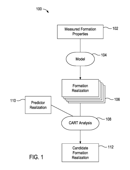
[0005] FIG. 1 provides a flow chart illustration of a method
according to some
embodiments of the present disclosure.
[0006] FIG. 2 illustrates an example of a CART analysis
lb
CA 3010531 2019-08-27
CA 03010531 2018-07-03
WO 2017/135969 PCT/1JS2016/016787
[0007] FIG. 3 is a schematic
diagram of an exemplary drilling
system.
[0008] FIG. 4 depicts a
schematic diagram of an exemplary wireline
system.
[0009] FIG. 5 illustrates a
CART analysis applied to a formation
realization.
[0010] FIG. 6 is a 3-
dimensional grid matrix or map of a data set
identified by the CART analysis of FIG. 5.
DETAILED DESCRIPTION
[0011] The present application
relates to selecting a candidate
formation realization from a plurality of formation realizations using a
classification and regression tree (CART) analysis that takes into account the
associations between petrophysical and geological properties. The identified
candidate formation realization may then be used as the basis for developing
the
parameters of subsequent wellbore operations.
[0012] Further, the CART
analysis described herein uniquely allows
for the analyzing associations between both numerical properties and
categorical
properties, which is a characteristic that other analysis techniques lack.
[0013] As used herein, the
term "numerical property" refers to a
property that has a corresponding numerical value or range of values.
Exemplary numerical properties that may be used in a CART analysis described
herein may include, but are not limited to, modulus of elasticity, in situ
facies
stresses, leak-off coefficient, Poisson's ratio, porosity, permeability, water
saturation, a hydrocarbon production amount, a proppant volume, and any
combination thereof.
[0014] As used herein, the
term "categorical property" refers to a
property that has classes or divisions that are not numerically graded.
Exemplary categorical properties that may be used in a CART analysis described
herein may include, but are not limited to, lithology facies, a type of
hydrocarbon(s) present in the formation, and any combination thereof. For
example, the classes of lithology facies may include, but are not limited to,
dolomite, shale, limestone, smectite, sandstone, clay (also known as
claystone),
chert, coal, diatomite, halite, anhydrite, gypsum, tuff, and the like.
2
CA 03010531 2018-07-03
WO 2017/135969 PCT/US2016/016787
[0015] The formation
properties used in the methods and analyses
described herein may be numerical properties, categorical properties, or a
combination thereof.
[0016] FIG. 1 provides a flow
chart illustration of a method 100
according to some embodiments of the present disclosure. Using measured
formation properties 102, a mathematical model 104 may be used to produce a
plurality of formation realizations 106 for a first property of the
subterranean
formation. Then, a CART analysis 108 may be applied to the plurality of
formation realizations 106 to partition each of the formation realizations 106
using a series of logic questions based on the first formation property
(described
in more detail below in FIG. 2). The partitioned formation realizations 106
are
then associated with a second formation property (known as a predictor) via
the
predictor realization 110 (or predictor map). Finally, the strength of the
association between the first formation property and the second formation
property is used to select at least one candidate formation realization 112.
For
example, the candidate formation realization(s) 112 that provides a strong
association between the first and second properties (or additional properties
when third, fourth, etc. properties are analyzed as described further herein)
may
then be used for predicting sweet spots (i.e., highly connected portions of a
formation with high amounts of a desired hydrocarbon), analyzing the reservoir
quality and potential production of the formation, and developing the
parameters
of subsequent wellbore operations (e.g., drilling operations, stimulation
operations, production operations, and the like). In some instances, more than
one candidate formation realization 112 may be selected for further analysis,
for
example, for identifying sweet spots in the subterranean formation.
[0017] An exemplary mathematical model 104 may be
DECISIONSPACEC) EARTH MODEL (a modeling software, commercially available
from Halliburton Energy Services, Inc.).
[0018] As used herein, the
formation realizations 106 is the outputs
of the mathematical model 104. Generally, the measured formation properties
102 are for only a portion of the formation. Accordingly, when considering a -
dimensional grid matrix of the subterranean formation, uncertainty arises from
points without data. To address this, a the model 104 uses a stochastic
process
(i.e., a process having a random probability distribution or pattern that may
be
analyzed statistically but may not be predicted precisely) to fill in the
data.
3
CA 03010531 2018-07-03
WO 2017/135969 PCT/US2016/016787
Because this is a stochastic process, multiple representations of the
formation
are possible. Accordingly, the mathematical model 104 produces a plurality of
formation realizations 106.
[0019] As used herein, the
formation realizations 106 are the output
of the mathematical model 104 and may be represented as 3-dimensional grid
matrices of the subterranean formation (also known as a geocellular grid), 1-
dimensional arrays representing the subterranean formation, and the like. In a
1-dimensional array, the data points of the formation (e.g., the data points
in
the geocellular grid) are converted to mathematical matrix having matrix
identification values corresponding to each data point.
[0020] FIG. 2 illustrates an
example of the CART analysis 108. The
CART analysis 108 recursively partitions data 200 into progressively smaller
groups 204,206,210,212 based on a "yes" or "no" answer to logic questions
202,208. In the illustrated example, the original data 200 is first
partitioned by a
logic question 202 into two data sets 204,206 based on the yes/no answer. The
partitioned data set 206 corresponding to the no answer is further partitioned
into two data sets 210,212 based on the yes/no answer to a logic question 208.
[0021] In the present
application and in reference to FIGS. 1 and 2,
the data 200 analyzed by the CART analysis 108 is formation realizations 106
produced by modeling a formation property and the logic questions is based on
that formation property. For example, each cell of the geocellular grid or
each
element of the 1-dimensional array is associated with a value for a numerical
property or categorical property. The partitioning is performed on a binary
basis
with a logic question based on the property. For example, a formation
realization
106 based on porosity, lithology facies, or water saturation may be
partitioned in
two groups corresponding to a "yes" or "no" answer to a logic question like
"Is
the porosity greater than 0.05 porosity units?," "Is the lithology facies
limestone?," or "Is the water saturation less than 0.25 saturation units?,"
respectively. The logic questions may be defined by a user of the CART
analysis
108 or determined by the CART analysis as described further herein. Then, the
smaller data sets may independently be further partitioned by another logic
question. Once the formation realization 106 is partitioned into data sets as
desired, the data points in each of the data sets are correlated to a data
point in
the predictor realization 110 based on location in a geocellular grid or each
4
CA 03010531 2018-07-03
WO 2017/135969
PCT/US2016/016787
matrix identification values in a 1-dimensional array. Then, the predictor
formation property has been associated with the formation realization
property.
[0022] By way
of nonlimiting example, a data set 200 corresponding
to a permeability formation realization may be partitioned into a yes data set
204 and a no data set 206 based on the logic question 202 "Is the permeability
greater than 0.1 millidarcy?" The yes data set 204 may include 25% of the
original data set 200, and the no data set 206 may include the other 75%.
Then,
the no data set 206 may be partitioned by the logic question 202 "Is the
permeability greater than 0.005 millidarcy?" The yes data set 210 may include
67% of the no data set 206, which is 50% of the original data set 200, and the
no data set 212 may include the other 33% of the no data set 206, which is
25% of the original data set 200. Then, a second property (i.e., the predictor
formation property) like the lithology facies may be associated with each of
the
terminal data sets 204,210,212. In this example, the percentage of data points
in each of the terminal data sets 204,210,212 that are sandstone, dolomite,
and
shale may be calculated. For example, data set 204 may have corresponding
lithology facies of: 80% sandstone, 15% dolomite, and 5% shale; the data set
210 may have corresponding lithology facies of: 5% sandstone, 75% dolomite,
and 20% shale; and the data set 212 may have corresponding lithology facies
.. of: 1 /0 sandstone, 15% dolomite, and 84% shale. In this example the
terminal
data sets 204,210,212, which were derived from partitioning based on
permeability, are also strongly segregated by lithology facies. Therefore, the
strength of the association between permeability and lithology facies is high
because permeability partitioning provided terminal nodes with over 7 5 /o of
the
data in each of the terminal nodes corresponding to a single lithology facie.
The
strength of association in the method 100 would be determined after the CART
analysis 108 by ranking how well the terminal nodes from each formation
realization associate to the second formation property (i.e., the predictor
formation property). The foregoing exemplary CART analysis may be performed
for the plurality of permeability formation realizations and the
realization(s) with
the strongest association between permeability and lithology facies may be
selected as the candidate formation realization(s) and used for further
analysis.
For example, two, three, or more formation realization having had the CART
analysis applied may have strong associations and all be used in subsequent
analyses like sweet spot identification or wellbore operation modeling.
5
CA 03010531 2018-07-03
WO 2017/135969 PCT/US2016/016787
[0023] The foregoing example
may be extended to other properties
like porosity or total organic content alternatively or in addition to the
examples
provided above. For example, the terminal data sets 204,210,212 may also be
correlated to an average porosity predictor realization or total organic
content
predictor realization. Then, the strength of each of the associations between
permeability and lithology facies, permeability and porosity, and permeability
and total organic content may be considered when selecting a candidate
formation realization 112. Therefore, in general, the CART analysis 108 may be
based on an association between a first formation property calculated by the
model 104 and one or more predictor formation properties, and selecting a
candidate formation realization 112 from the plurality of formation
realizations
106 may be based on the strength of the association between the first
formation
property and the one or more predictor formation properties.
[0024] In some instances, the
CART analysis 108 may determine the
logic questions 202,208. For example, the logic question 202 may be "Is the
permeability greater than x millidarcy?" and the CART analysis 108 may
iteratively change x from 0.001 to 1. For each iteration, the CART analysis
108
also calculates the percent of sandstone, dolomite, and shale in each of the
yes
and no data sets 204,206. The value for x that provides for the greatest
difference between the percent of sandstone, dolomite, and/or shale in the two
data sets 204,206 is selected to populate the logic question 202. The
difference
between the two data sets may be according to a Gini coefficient or entropy
index when comparing categorical properties or according to an average, sums
of squares, or the like when comparing numerical properties. This procedure is
then repeated for determining the logic question 208, which may be "Is the
permeability greater than y millidarcy?"
[0025] In the foregoing
examples, both logic questions 202,208 are
based on a single property because the formation realizations 106 are produced
with a single property. However, alternatively, the model 104 may use the
measured formation properties 102 and simultaneously calculate two or more
formation properties to produce a plurality of formation realizations 106
where
each location in a geocellular grid or each matrix identification values in a
1-
dimensional array has a value for each of the two or more formation properties
calculated by the model 104. Then, the logic questions 202,208 may be based
on different properties. For example, if the model produces corresponding
6
CA 03010531 2018-07-03
WO 2017/135969 PCT/US2016/016787
permeability and porosity formation realizations, the logic question 202 may
be
"Is the permeability greater than x millidarcy?," and the logic question 208
may
be "Is the porosity greater than y porosity units?"
[0026] Further, while the
foregoing examples illustrate a CART
analysis 108 with only three terminal data sets 204,210,212, the CART analysis
applied to each of the formation realizations 106 may be configured with any
number of terminal data sets (e.g., 2-10 or more terminal data sets).
[0027] In some instances, the
candidate formation realization 112
may be further analyzed. For example, one or more of the partitioned data sets
(terminal or otherwise) may be mapped, visualized, or otherwise analyzed to
determine the connectivity of the volume of the subterranean formation
corresponding to the partitioned data set. For example, a data set that is
associated with high total organic carbon and high permeability may be shown
in
a geocellular grid, which, as described above, is a 3-dimensional map of the
formation. If the geocellular grid or map illustrates high connectivity, a
subsequent fracturing operation may focus on increasing fractures near this
volume of the subterranean formation. Alternatively, the geocellular grid or
map
may illustrate that the data set corresponds to two separate volumes of the
subterranean formation each with high connectivity. Accordingly, the
subterranean formation may contain fractures in two locations that should be
appropriately stimulated.
[0028] In some instances, the
candidate formation realization 112
may be used to develop the parameters of subsequent wellbore operations (e.g.,
drilling operations, stimulation operations, production operations, and the
like).
For example, the candidate formation realization 112 may be used in a program
or model that simulates drilling, and the drilling parameters may be derived
from
the simulated drilling operation.
[0029] In some instances, the
candidate formation realization 112
may be used to determine if and where zonal isolation should be implemented.
For example, the candidate formation realization 112 may have a portion of the
formation with a high water content, which may be isolated with packers or
other tools to mitigate water production.
[0030] In some instances, the
candidate formation realization 112
may be used to predict the sweet spots. For example, the candidate formation
7
CA 03010531 2018-07-03
WO 2017/135969 PCT/US2016/016787
realization 112 may be used to predict a productive zone as sweet spot in a
subterranean formation with very high connectivity.
[0031] In some instances, the
candidate formation realization 112
may be used to analyze or otherwise calculate the reservoir quality and
potential
production of the formation.
[0032] The methods described
herein may be implemented by a set
of instructions that cause a processor to perform the CART analysis 108 of the
formation realizations 106. In some instances, the processor and set of
instructions may also be used for modeling the formation realizations 106. In
some instances, the processor and set of instructions may also be used for
modeling a subterranean operation based on the candidate formation realization
112.
[0033] The processor may be a
portion of computer hardware used
to implement the various illustrative blocks, modules, elements, components,
methods, and algorithms described herein. The processor may be configured to
execute one or more sequences of instructions, programming stances, or code
stored on a non-transitory, computer-readable medium. The processor can be,
for example, a general purpose microprocessor, a microcontroller, a digital
signal
processor, an application specific integrated circuit, a field programmable
gate
array, a programmable logic device, a controller, a state machine, a gated
logic,
discrete hardware components, an artificial neural network, or any like
suitable
entity that can perform calculations or other manipulations of data. In some
embodiments, computer hardware can further include elements such as, for
example, a memory (e.g., random access memory (RAM), flash memory, read
only memory (ROM), programmable read only memory (PROM), erasable
programmable read only memory (EPROM)), registers, hard disks, removable
disks, CD-ROMS, DVDs, or any other like suitable storage device or medium.
[0034] Executable sequences
described herein can be implemented
with one or more sequences of code contained in a memory. In some
embodiments, such code can be read into the memory from another machine-
readable medium. Execution of the sequences of instructions contained in the
memory can cause a processor to perform the process steps described herein.
One or more processors in a multi-processing arrangement can also be
employed to execute instruction sequences in the memory. In addition, hard-
wired circuitry can be used in place of
or in combination with software
8
CA 03010531 2018-07-03
WO 2017/135969 PCT/US2016/016787
instructions to implement various embodiments described herein. Thus, the
present embodiments are not limited to any specific combination of hardware
and/or software.
[0035] As used herein, a
machine-readable medium will refer to any
medium that directly or indirectly provides instructions to the processor for
execution. A machine-readable medium can take on many forms including, for
example, non-volatile media, volatile media, and transmission media. Non-
volatile media can include, for example, optical and magnetic disks. Volatile
media can include, for example, dynamic memory. Transmission media can
include, for example, coaxial cables, wire, fiber optics, and wires that form
a
bus. Common forms of machine-readable media can include, for example, floppy
disks, flexible disks, hard disks, magnetic tapes, other like magnetic media,
CD-
ROMs, DVDs, other like optical media, punch cards, paper tapes and like
physical
media with patterned holes, RAM, ROM, PROM, EPROM and flash EPROM.
[0036] In some embodiments,
the measured formation properties
102 may be gathered using measurement-while-drilling (MWD) and logging-
while-drilling (LWD) tools, wireline tools, or combinations thereof. Exemplary
wellbore tools suitable for gathering measured formation properties may
include,
but are not limited to, nuclear magnetic resonance tools, gamma ray logging
tools, density logging tools, neutron logging tools, geochemical logging
tools,
mud logging tools, resistivity logging tools, acoustic logging tools, sonic
logging
tools, borehole imaging logging tools, temperature logging tools, and the
like,
and any combination thereof. The foregoing wellbore tools may, as suitable, be
conveyed along the wellbore and perform corresponding measurements while
drilling (i.e., as MWD/LWD tools), while one a wireline or other suitable
conveyance (i.e., as wireline tools), or, when two or more tools are used,
each
may independently be a MWD/LWD tool or a wireline tool.
[0037] FIG. 3 is a schematic
diagram of an exemplary drilling
system 300 that may employ the principles of the present disclosure, according
to one or more embodiments. As illustrated, the drilling system 300 may
include a drilling platform 302 positioned at the Earth's surface and a
wellbore
304 that extends from the drilling platform 302 into one or more subterranean
formations 306. In other embodiments, such as in an offshore or subsea
drilling
operation, a volume of water may separate the drilling platform 302 and the
wellbore 304.
9
CA 03010531 2018-07-03
WO 2017/135969 PCT/US2016/016787
[0038] The drilling system 300
may include a derrick 308 supported
by the drilling platform 302 and having a traveling block 310 for raising and
lowering a drill string 312. A kelly 314 may support the drill string 312 as
it is
lowered through a rotary table 316. A drill bit 318 may be coupled to the
drill
string 312 and driven by a downhole motor and/or by rotation of the drill
string
312 by the rotary table 316. As the drill bit 318 rotates, it creates the
wellbore
304, which penetrates the subterranean formations 306. A pump 320 may
circulate drilling fluid through a feed pipe 322 and the kelly 314, downhole
through the interior of drill string 312, through orifices in the drill bit
318, back
to the surface via the annulus defined around drill string 312, and into a
retention pit 324. The drilling fluid cools the drill bit 318 during operation
and
transports cuttings from the wellbore 304 into the retention pit 324.
[0039] The drilling system 300
may further include a bottom hole
assembly (BHA) coupled to the drill string 312 near the drill bit 318. The BHA
may comprise one or more MWD/LWD tools 326 configured to take downhole
measurements of drilling conditions and/or properties of the surrounding
subterranean formation 306. As the drill bit 318 extends the wellbore 304
through the formations 306, the MWD/LWD tools 326 may collect the measured
formation property(s) of the subterranean formation 306. The MWD/LWD tools
326 may be communicably coupled (wired or wirelessly) for transferring data to
a telemetry module 328 used for further transferring measurements and signals
from the BHA to a surface receiver (not shown) and/or to receive commands
from the surface receiver. The telemetry module 328 may encompass any
known means of downhole communication including, but not limited to, a mud
pulse telemetry system, an acoustic telemetry system, a wired communications
system, a wireless communications system, or any combination thereof. In some
embodiments, the telemetry module 328 may be omitted and the drill string 312
may instead comprise wired drill pipe or wired coiled tubing used to transfer
data via wired conductors to a surface receiver. In certain embodiments, some
or all of the measurements taken by the MWD/LWD tools 326 may be stored
within the MWD/LWD tools 326, BHA, and/or the telemetry module 328 for later
retrieval at the surface upon retracting the drill string 312.
[0040] At various times during
or after the drilling process, including
after stimulation operations, the drill string 312 or other apparatus
extending
into the wellbore (e.g., a work string for perforating the formation) may be
CA 03010531 2018-07-03
WO 2017/135969 PCT/US2016/016787
removed from the wellbore 304, as shown in FIG. 4, to conduct
measurement/logging operations. More particularly, FIG. 4 depicts a schematic
diagram of an exemplary wireline system 400 that may employ the principles of
the present disclosure, according to one or more embodiments. Like numerals
used in FIGS. 3 and 4 refer to the same components or elements and, therefore,
may not be described again in detail. As illustrated, the wireline system 400
may
include a one or more wireline tools 402 that may be suspended into the
wellbore 304 by a cable 404. The wireline tools 402 may be communicably
coupled to the cable 404. The cable 404 may include conductors for
transporting
power to the wireline tools 402 and also facilitate communication between the
surface and the wireline tools 402. A logging facility 406, shown in FIG. 4 as
a
truck, may collect measurements from the wireline tools 402, and may include
computing facilities 408 for controlling, processing, storing, and/or
visualizing
the measurements gathered by the wireline tools 402. The computing facilities
408 may be communicably coupled to the wireline tools 402 by way of the cable
404.
[0041] In each of the
foregoing drilling and wireline systems, the
methods and processes described herein (or portions thereof) that utilize the
CART analysis may be implemented on-site (e.g., at a computer or processor
on-site like the computing facilities 408 illustrated in the wireline system
of FIG.
4 or a similar computing facility at the drilling system of FIG. 3).
Alternatively or
in conjunction therewith, the methods and processes described herein (or
portions thereof) that utilize the CART analysis may be performed off-site
where
the measured formation properties 102 are transmitted (wired or wirelessly) or
physically delivered to the off-site location.
[0042] Examples described
herein include, but are not limited to,
Examples A-C.
[0043] Example A is a method
comprising: applying a classification
and regression tree algorithm (CART) analysis to a plurality of formation
realizations using a first formation property of a subterranean formation as a
predictor in the CART analysis, wherein the plurality of formation
realizations are
for a second formation property and are based on at least one measured
formation property, thereby yielding an association between the first and
second
properties for each of the plurality of formation realizations; analyzing a
strength
of the association for each of the plurality of formation realizations; and
11
CA 03010531 2018-07-03
WO 2017/135969 PCT/US2016/016787
selecting a candidate formation realization from the plurality of formation
realizations based on the strength of the association.
[0044] Example B is a system
comprising: a wellbore tool (e.g., any
of the wellbore tools (wireline or MWD/LWD) described herein or similar tools)
placed along a wellbore extending into a subterranean formation; a non-
transitory computer-readable medium coupled to the wellbore tool to receive a
measured formation property from the wellbore tool and encoded with
instructions that, when executed, perform operations comprising: applying a
classification and regression tree algorithm (CART) analysis to a plurality of
formation realizations using a first formation property of a subterranean
formation as a predictor in the CART analysis, wherein the plurality of
formation
realizations are for a second formation property and are based on at least one
measured formation property, thereby yielding an association between the first
and second properties for each of the plurality of formation realizations;
analyzing a strength of the association for each of the plurality of formation
realizations; and selecting a candidate formation realization from the
plurality of
formation realizations based on the strength of the association.
[0045] Example C is a non-
transitory computer-readable medium
encoded with instructions that, when executed, perform operations comprising:
applying a classification and regression tree algorithm (CART) analysis to a
plurality of formation realizations using a first formation property of a
subterranean formation as a predictor in the CART analysis, wherein the
plurality
of formation realizations are for a second formation property and are based on
at least one measured formation property, thereby yielding an association
between the first and second properties for each of the plurality of formation
realizations; analyzing a strength of the association for each of the
plurality of
formation realizations; and selecting a candidate formation realization from
the
plurality of formation realizations based on the strength of the association.
[0046] Each of Examples A, B,
and C may independently, optionally
further include any one or more of the following alternatively or
additionally:
Element 1: the method further comprising (or the instructions that, when
executed, perform operations that further comprise) modeling the second
formation property for the subterranean formation based on the at least one
measured formation property, thereby producing the plurality of formation
realizations that are then used in the CART analysis; Element 2: wherein the
12
CA 03010531 2018-07-03
WO 2017/135969
PCT/US2016/016787
predictor is a first predictor and the method further comprising (or the
instructions that, when executed, perform operations that further comprise)
using a third formation property of a subterranean formation as a second
predictor in the CART analysis, wherein the association is between the first,
.. second, and third properties; Element 3: the method further comprising (or
the
instructions that, when executed, perform operations that further comprise)
developing parameters for a wellbore operation based on the candidate
formation realization; Element 4: Element 3 and the method further comprising
(or the instructions that, when executed, perform operations that further
comprise) performing the wellbore operation on the subterranean formation
based on the parameters developed; Element 5: wherein the CART analysis
produces two or more data sets partitioned based on the first property, and
wherein the method further comprises: mapping one of the two or more data
sets to geocellular grid of the subterranean formation; Element 6: wherein the
first property is a categorical property; Element 7: wherein the second
property
is a categorical property; Element 8: wherein the first property is a
numerical
property; Element 9: wherein the second property is a numerical property;
Element 10: wherein the first property of the subterranean formation is
selected
from the group consisting of: a lithology facies, a type of hydrocarbon, a
.. porosity, a permeability, a water saturation, an hydrocarbon production
amount,
a proppant volume, a modulus of elasticity, in situ facies stresses, a leak-
off
coefficient, and a Poisson's ratio; Element 11: wherein the second property of
the subterranean formation is selected from the group consisting of: a
lithology
facies, a type of hydrocarbon, a porosity, a permeability, a water saturation,
an
hydrocarbon production amount, a proppant volume, a modulus of elasticity, in
situ facies stresses, a leak-off coefficient, and a Poisson's ratio; Element
12:
wherein the plurality of formation realizations are 3-dimensional grid
matrices of
the subterranean formation; Element 13: wherein the plurality of formation
realizations are 1-dimensional arrays of the subterranean formation; Element
14: wherein the plurality of formation realizations is a plurality of first
formation
realizations, and wherein the method further comprises (or the instructions
that,
when executed, perform operations that further comprise) applying the CART
analysis to a plurality of second formation realizations using the first
formation
property as the predictor in the CART analysis, wherein the plurality of
second
formation realizations are for a third formation property; and wherein the
13
CA 03010531 2018-07-03
WO 2017/135969 PCT/US2016/016787
association is further between the first and third formation properties for
each of
the plurality of second formation realizations; Element 15: Element 14 and the
method further comprising (or the instructions that, when executed, perform
operations that further comprise) modeling the second and third formation
properties for the subterranean formation based on at least one measured
formation property, thereby producing the plurality of first formation
realizations
and the plurality of second formation realizations that correspond and are
then
used in the CART analysis; Element 16: Element 14 and wherein the third
property is a categorical property; Element 17: Element 14 and wherein the
third property is a numerical property; Element 18: Element 14 and wherein the
third property of the subterranean formation is selected from the group
consisting of: a lithology facies, a type of hydrocarbon, a porosity, a
permeability, a water saturation, an hydrocarbon production amount, a proppant
volume, a modulus of elasticity, in situ facies stresses, a leak-off
coefficient, and
a Poisson's ratio; Element 19: the method further comprising (or the
instructions
that, when executed, perform operations that further comprise) measuring the
at least one measured formation property with a wellbore tool (e.g., any of
the
wellbore tools (wireline or MWD/LWD) described herein or similar tools); and
Element 20: wherein the at least one measured formation property is two or
more formation measured properties including a first measured formation
property is from a wireline tool and the second measured formation property is
from a MWD/LWD tool.
[0047] By way of nonlimiting
examples, suitable combinations may
include, but are not limited to, one or more of Elements 1, 2, 3, 4, 5, 10,
11, 12,
13, 14 (which, when in combination with Element 2, the reference to third
formation property in Element 14, and any dependent Elements, is updated
accordingly to fourth formation property), 19, or 20 in combination; one of
Elements 6-7 in combination with one of Elements 8-9 and optionally in further
combination with Element 14 and optionally Element 15, Element 18, and/or one
of Elements 16-17; one of Elements 6-7 in combination with Element 14 and
optionally Element 15, Element 18, and/or one of Elements 16-17; one of
Elements 8-9 in combination with Element 14 and optionally Element 15,
Element 18, and/or one of Elements 16-17; Elements, 1, 14, and 15 in
combination and optionally in further combination with one of Elements 6-7
and/or one of Elements 8-9; Element 5 and/or Element 3 (optionally with
14
CA 03010531 2018-07-03
WO 2017/135969 PCT/US2016/016787
Element 4) in combination with Element 1; Element 5 and/or Element 3
(optionally with Element 4) in combination with Element 2; Element 5 and/or
Element 3 (optionally with Element 4) in combination with Element 14 and
optionally Element 15, Element 18, and/or one of Elements 16-17; Element 5
and/or Element 3 (optionally with Element 4) in combination with Element 19;
Element 5 and/or Element 3 (optionally with Element 4) in combination with
Element 20; Element 19 and/or Element 20 in combination with Element 1;
Element 19 and/or Element 20 in combination with Element 2; Element 19
and/or Element 20 in combination with Element 14 and optionally Element 15,
Element 18, and/or one of Elements 16-17; and combinations thereof.
[0048] Unless otherwise
indicated, all numbers expressing quantities
like formation properties, and so forth used in the present specification and
associated claims are to be understood as being modified in all instances by
the
term "about." Accordingly, unless indicated to the contrary, the numerical
parameters set forth in the following specification and attached claims are
approximations that may vary depending upon the desired properties sought to
be obtained by the embodiments of the present disclosure. At the very least,
and not as an attempt to limit the application of the doctrine of equivalents
to
the scope of the claim, each numerical parameter should at least be construed
in
light of the number of reported significant digits and by applying ordinary
rounding techniques.
[0049] One or more
illustrative embodiments incorporating the
present disclosure are presented herein. Not all features of a physical
implementation are described or shown in this application for the sake of
clarity.
It is understood that in the development of a physical embodiment
incorporating
the embodiments of the present disclosure, numerous implementation-specific
decisions must be made to achieve the developer's goals, such as compliance
with system-related, business-related, government-related and other
constraints, which vary by implementation and from time to time. While a
developer's efforts might be time-consuming, such efforts would be,
nevertheless, a routine undertaking for those of ordinary skill in the art and
having benefit of this disclosure.
[0050] While compositions and
methods are described herein in
terms of "comprising" various components or steps, the compositions and
CA 03010531 2018-07-03
WO 2017/135969 PCT/US2016/016787
methods can also "consist essentially of" or "consist of" the various
components
and steps.
[0051] To facilitate a better
understanding of the embodiments of
the present disclosure, the following examples of preferred or representative
embodiments are given. In no way should the following examples be read to
limit, or to define, the scope of the present disclosure.
EXAMPLES
[0052] The porosity of a
subterranean formation was modeled based
on logging data to produce 25 formation realizations that were mapped onto a
geocellular grid. A lithology facies predictor realization was provided for
the
formation in a geocellular grid. Each of the 25 formation realizations were
subjected to a CART analysis. The terminal data sets based on the porosity-
based logic questions were then correlated to the lithology facies in the
predictor
realization.
[0053] For example, FIG. 5
illustrates the CART analysis of the 23rd
realization ("Realization 23"). First, the full data set 500 of Realization
was
correlated to the lithology facies in the predictor realization yielding 56%
shale,
28% limestone, and 16% dolomite. The logic question 502 applied to the data
set 500 was "Is the porosity less than 7.4%?," which according to the CART
analysis best split or partitioned the data set 500 of Realization 23 into two
data
sets: a yes data set 504 that is 25% of the original data set 500 and a no
data
set 506 that is 75% of the original data set 500. The yes data set 504 has a
lithology facies composition that is 40% dolomite, 49% limestone, and 110/0
shale, and the no data set 506 has a lithology facies composition that is 8%
dolomite, 20% limestone, and 72% shale. The resultant no data set 506 is
primarily shale. The resultant yes data set 504 is not clearly dolomite or
limestone, so a second split was performed. The yes data set 504 was
partitioned again according to the second logic question "Is the porosity
greater
than or equal to 6.8%?" to yield a yes data set 510 that is 19% of the
original
data set 500 and a no data set 512 that is 6% of the original data set 500.
The
yes data set 510 has a lithology facies composition that is 46% dolomite, 41%
limestone, and 13% shale, which is primarily dolomite. The no data set 512 has
a lithology facies composition that is 22% dolomite, 76% limestone, and 2%
shale, which is primarily limestone. The CART analysis of Realization 23 shows
a
16
strong association between the lithology facies and the porosity. Therefore,
Realization 23
may be further analyzed. For example, if the volume corresponding to the data
set 510 that
is predominantly dolomite is of interest, a user of the CART analysis may
visualize just that
portion of the formation to analyze the connectivity of the volume within the
formation. FIG.
6 is a 3-dimensional grid matrix or map of the data set 510. Based on this
connectivity
analysis, the well placement and sweet spot prediction may be developed.
[0054]
Therefore, the present disclosure is well adapted to attain the ends
and advantages mentioned as well as those that are inherent therein. The
particular
embodiments disclosed above are illustrative only and may be modified and
practiced in
different but equivalent manners apparent to those skilled in the art having
the benefit of
the teachings herein. Furthermore, no limitations are intended to the details
of construction
or design herein shown. It is therefore evident that the particular
illustrative embodiments
disclosed above may be altered, combined, or modified and all such variations
are
considered within the scope and spirit of the present disclosure. The
embodiments
illustratively disclosed herein suitably may be practiced in the absence of
any element that
is not specifically disclosed herein and/or any optional element disclosed
herein. While
compositions and methods are described in terms of "comprising," "containing,"
or
"including" various components or steps, the compositions and methods can also
"consist
essentially of" or "consist of" the various components and steps. All numbers
and ranges
disclosed above may vary by some amount. Whenever a numerical range with a
lower limit
and an upper limit is disclosed, any number and any included range falling
within the range
is specifically disclosed. In particular, every range of values (of the form,
"from about a to
about b," or, equivalently, "from approximately a to b," or, equivalently,
"from
approximately a-b") disclosed herein is to be understood to set forth every
number and
range encompassed within the broader range of values. Also, the terms used
herein have
their plain, ordinary meaning unless otherwise explicitly and clearly defined
by the patentee.
Moreover, the indefinite articles "a" or "an," as used herein, are defined
herein to mean one
or more than one of the element that it introduces.
17
CA 3010531 2019-08-27