Note: Descriptions are shown in the official language in which they were submitted.
METHOD AND SYSTEM FOR PLANNING ROUTES FOR COMMERCIAL
MOTOR VEHICLES
TECHNICAL FIELD
[0001] Embodiments relate to methods and systems for planning routes for
commercial
motor vehicles.
BACKGROUND
[0002] Commercial motor vehicles (CMV) and their respective drivers and
carriers are
required by various federal regulations and international agreements to comply
with rules
governing the safe operation of the vehicles. One way in which safety is
promoted is through
hours-of-service (HOS) regulations. These regulations prohibit drivers from
operating
vehicles more than a specified amount of time between mandatory off-duty
status periods. In
many instances, dispatchers are responsible for routing drivers. For example,
a dispatcher
sends a driver a preplanned travel route, which may have one or more
preplanned stops based
on the projected travel time and the maximum number of driving hours for the
particular
driver. However, various road conditions (such as traffic, construction, etc.)
and driver
associated situations (for example, taking time for off-duty status at a
restaurant, diner, or
like) can dynamically change and result in the driver not being able to meet
hours-of service
regulations.
SUMMARY
[0003] As a consequence of changing road and driver conditions, it is
desirable to have a
system for route planning that can accommodate such dynamics. Calculating
hours-of-
service availability using current methods can be a time-consuming process
because it
involves tracking the time spent by a large number of drivers inside a geo-
fence.
Additionally, keeping track of the amount of time spent in each hours-of-
service status for
these drivers inside a geo-fence adds to the level of complexity. Methods and
systems
provided herein allows to combine all of the above data to determine and
display (using a
graphical user interface) particular routes for drivers to take while staying
compliant to the
hours-of-service requirements. Embodiments provided herein help improve
compliance with
CA 3011530 2018-07-17
¨ ¨
hours-of-service regulations and provides an efficient routing system for
commercial motor
vehicles. Additionally, embodiments of the invention also improves order
processing
efficiency resulting in improved fuel efficiency, wear and tear on commercial
motor vehicles.
More efficient routing, for example, routing that avoids road construction,
accidents, etc.,
reduces fuel consumption. Moreover, embodiments provided herein include a
graphical user
interface to display compliant routes with respect to hours-of-service
requirements on which
commercial motor vehicles may be deployed. Furthermore, data transmissions are
reduced as
a result of less instances of hours of service violations. Of course, fuel
consumption is a
significant issue for operators of commercial vehicles and has significant
impacts on both
operating costs and the generation of greenhouse gases and other potentially
undesirable
emissions.
[0004] Various systems and methods are described in connection with route
planning for
commercial vehicles. One embodiment provides a base unit comprising an
electronic
processor configured to receive geo-fence activity data associated with a
plurality of users of
vehicles entering into a geo-fenced region and exiting out of the geo-fenced
region; generate
hours-of-service data associated with the plurality of users of vehicles;
determine a geo-fence
activity time associated with the plurality of users of vehicles based on the
geo-fence activity
data; determine an hours-of-service availability time for each of the
plurality of users of
vehicles based on the hours-of-service data and the geo-fence activity
associated with each of
the plurality of users of vehicles; determine a compliant route for a first
vehicle based on the
hours-of-service availability time; and display the compliant route for the
first vehicle.
[0005] Another embodiment provides a system for planning routes based on
historical
activity within a geo-fenced region. The system includes a base unit including
an electronic
processor configured to receive geo-fence activity data associated with a
plurality of users of
vehicles entering into a geo-fenced region and exiting out of the geo-fenced
region; generate
hours-of-service data associated with the plurality of users of vehicles;
determine a geo-fence
activity time associated with the plurality of users of vehicles based on the
geo-fence activity
data; determine an hours-of-service availability time for each of the
plurality of users of
vehicles based on the hours-of-service data and the geo-fence activity
associated with each of
2
CA 3011530 2018-07-17
¨ .
the plurality of users of vehicles; determine a compliant route for a first
vehicle based on the
hours-of-service availability time; and display the compliant route for the
first vehicle.
[0006] Another embodiment provides a method for planning routes based on
historical
activity within a geo-fenced region. The method includes receiving geo-fence
activity data
associated with a plurality of users of vehicles entering into a geo-fenced
region and exiting
out of the geo-fenced region; generating hours-of-service data associated with
the plurality of
users of vehicles; determining a geo-fence activity time associated with the
plurality of users
of vehicles based on the geo-fence data; determining an hours-of-service
availability time for
each of the plurality of users of vehicles based on the hours-of-service data
and the geo-fence
activity associated with each of the plurality of users of vehicles;
determining a compliant
route for a first vehicle based on the hours-of-service availability time; and
displaying the
compliant route for the first vehicle.
[0007] Thus, embodiments described herein, provide, among other things,
methods and
systems for planning routes for commercial motor vehicles. Other aspects of
the various
embodiments will become apparent by consideration of the detailed description
and
accompanying drawings that follow.
BRIEF DESCRIPTION OF THE SEVERAL VIEWS OF THE DRAWINGS
[0008] The accompanying figures, where like reference numerals refer to
identical or
functionally similar elements throughout the separate views, together with the
detailed
description below, are incorporated in and form part of the specification, and
serve to further
illustrate embodiments of concepts that include the claimed invention, and
explain various
principles and advantages of those embodiments.
[0009] FIG. I schematically illustrates a route planning system in accordance
with some
embodiments.
[0010] FIG. 2 is a block diagram of a base unit included in the system of FIG.
I in
accordance with some embodiments.
[0011] FIG. 3 is a block diagram of the memory of the base unit shown in FIG.
2, in
accordance with some embodiments.
3
CA 3011530 2018-07-17
=
[0012] FIG. 4 illustrates a commercial motor vehicle operating within a geo-
fenced region, in
accordance with some embodiments.
[0013] FIG. 5 is diagram illustrating the method of route planning based on
historical activity,
in accordance with some embodiments.
[0014] FIG. 6 is a flow chart illustrating a method for planning routes based
on historical
activity within a geo-fenced region, in accordance with some embodiments.
[0015] Skilled artisans will appreciate that elements in the figures are
illustrated for
simplicity and clarity and have not necessarily been drawn to scale. For
example, the
dimensions of some of the elements in the figures may be exaggerated relative
to other
elements to help to improve understanding of embodiments of the present
invention.
[0016] The apparatus and method components have been represented where
appropriate by
conventional symbols in the drawings, showing only those specific details that
are pertinent
to understanding the embodiments of the present invention so as not to obscure
the disclosure
with details that will be readily apparent to those of ordinary skill in the
art having the benefit
of the description herein.
DETAILED DESCRIPTION
[0017] Electronic logging devices (ELD) (for example, a base unit) may contain
hardware,
software, and other components that are used to determine the position of
commercial motor
vehicle (CMV). ELDs are subject to particular accuracy and availability
requirements
mandated by the Federal Motor Carrier Safety Administration (FMCSA).
Embodiments
provided herein allow for planning routes or choosing jobs for commercial
motor vehicles by
predicting how a geographic region will affect a particular driver's Hours-of-
Service
availability time that is remaining. A route planning application analyzes
prior activity of
commercial motor vehicles inside a geo-fenced region and determines Hours-of-
Service
violations for drivers and assists in scheduling routes for commercial motor
vehicles.
Additionally, the route planning application provided herein analyzes Hours-of-
Service
requirements based on the geographical location of commercial motor vehicles
and the time
accumulated by drivers of commercial vehicles in various categories including
"On-duty
4
CA 3011530 2018-07-17
status," "Driving status," "On-duty Not Driving status," "off-duty status,"
"sleeper berth
status," etc. Being able to analyze specific regions and conditions that have
the biggest
impact on Hours-of-Service time could help customers avoid jobs that have a
history of
delays compared to other regions. Currently available systems are inefficient
in routing
commercial motor vehicles because they often do not take into account Hours-of-
Service
related data associated with the drivers along with geo-fence activity data.
Using
embodiments provided herein, drivers can be sent to more jobs without
violating Hours-of
Service limits stipulated by the Federal Motor Carrier Safety Administration.
[0018] FIG. 1 illustrates a route planning system 100 for use with a vehicle
104. Although
the vehicle 104 is illustrated as a commercial vehicle in the form of a
tractor configured to
tow a trailer (not shown), the route planning system 100 can also be
implemented in or
otherwise used in connection with other types of vehicles, such as
construction vehicles,
agricultural equipment, and passenger vehicles. The vehicle 104 includes an
engine 108 (for
example, an internal combustion engine) that supplies mechanical power to the
vehicle 104.
The engine 108 is controlled by an electronic control unit (ECU) 112. The ECU
112
monitors operating parameters of the vehicle 104 and controls the engine 108
and other parts
of the vehicle 104 based on the monitored parameters. Operating parameters
monitored by
the ECU 112 include speed, hours of engine operation, ignition state, trip
distance, total
distance traveled by vehicle 104, and the like.
[0019] In one embodiment, the route planning system 100 includes an electronic
on-board
recorder ("EOBR") base unit 116, one or more portable communication devices
120 (that are
external to the base unit 116), and a remote server 123 running a host
application 124. In the
example illustrated in FIG. 1, the base unit 116 communicates with the ECU 112
through a
data bus 118. The base unit 116 also communicates with the portable
communication devices
120 through a wired or wireless link 122. The portable communication device
120 may be a
smart phone, a tablet computer, a laptop computer, a smart watch, or another
computing
device upon which software can be readily run, that can wirelessly connect to
other devices,
and that can be carried and moved by a user. In the example illustrated in
FIG. 1, the
portable communication device 120 wirelessly communicates with the remote
server 123
CA 3011530 2018-07-17
over a communication network 130 using a cellular network connection with a
cellular tower
126 or the Internet (for example, using a Wi-Fi connection).
[0020] The base unit 116 performs a plurality of functions including, for
example, time
keeping and data logging. In one implementation, the base unit 116 records and
stores
vehicle data (for example, data for complying with Federal Motor Carrier
Safety
Administration ("FMCSA") regulations), such as vehicle operating parameters
monitored by
the ECU 112.
[0021] In the example shown, the base unit 116 is powered via a connection to
a battery (for
example, a 12 volt or 24 volt vehicle battery). In some embodiments, the base
unit 116 is
configured to operate in a fully operational mode and a sleep mode to conserve
power. When
the base unit 116 is in the fully operational mode, the base unit 116 obtains
and, in some
instances stores vehicle data received from the ECU 112. For example, data may
be obtained
by the base unit 116 from the ECU 112 substantially in real-time or at a
predefined frequency
or interval. When the base unit 116 is communicatively coupled with the
portable
communication device 120, the base unit 116 may obtain data (for example, data
related to
positioning information) from the portable communication device 120
substantially in real-
time or at a predefined frequency or interval. In one example, the base unit
116 can send data
regarding the vehicle 104 and a request for positioning information to the
portable
communication device 120.
[0022] In the example shown in FIG. 2, the base unit 116 includes an
electronic processor
204 (such as a microprocessor, controller, or application-specific-integrated
circuit ("ASIC")
and at least one memory 205. The memory 205 includes non-transitory computer
readable
medium. In some embodiments, the memory 205 includes a geo-fence activity
database 302
and an hours-of-service activity database 304 (shown in FIG. 3). As described
in more detail
below, the memory 205 stores instructions that, when executed by the
electronic processor
204, logs vehicle data, logs data retrieval history, logs geo-fence activity
data, logs hours-of-
service activity data, and processes data received from the ECU 112 and other
devices and
systems external to the base unit 116. Accordingly, as described herein, the
base unit 116
performs particular functionality by executing instructions with the
electronic processor 204.
6
CA 3011530 2018-07-17
[0023] In the example shown, the base unit 116 also includes a clock 210, a
position
information device 211, such as global positioning system ("GPS") receiver, an
accelerometer 212, and a display unit 213. The clock 210 provides a clock
function to allow
the base unit 116 to accurately determine a time with a predetermined
resolution (for example,
approximately one second). The clock 210 is powered by a battery that provides
power to the
clock 210 even when the vehicle 104 does not provide power to the base unit
116. In some
embodiments, the clock 210 is configured to obtain an updated time from the
GPS 211.
[0024] The GPS receiver 211 includes an antenna 215, which can be internal to
the base unit
116. Positioning the antenna 215 internal to the base unit 116 makes the
antenna 215 more
tamper-proof than if the antenna 215 were positioned external to the base unit
116. Based on
data received by the antenna 215 from one or more external satellites 128 (see
FIG. 1), the
GPS receiver 211 provides positioning information to the electronic processor
204. The
positioning information can include coordinates (for example, latitude and
longitude
coordinates), a speed, a heading, a time, and a quality value. In some
embodiments, the GPS
receiver 211 updates the positioning information at a predetermined frequency
(for example,
approximately once per second). The GPS receiver 211 remains active when the
vehicle 104
is in motion and whenever the vehicle ignition is "on." When the base unit 116
is in sleep
mode, the GPS receiver 211 may be activated periodically after a predetermined
period of
time. In some embodiments, the base unit 116 may not include the GPS receiver
211, or the
accelerometer 212 as described above.
[0025] The display unit 213 displays data to a user of the base unit 116. For
example, the
display unit 213 can include one or more LEDs 216. The LEDs 216 indicate a
status of the
base unit 116. For example, the LEDs 216 can be used to indicate whether the
portable
communication device 120 connected to the base unit 116 is properly
functioning (for
example, a connection status), whether signals are being communicated between
the base unit
116 and the ECU 112 (for example, a communication status), and whether signals
are being
communicated between the base unit 116 and the portable communication device
120 (for
example, a mobile communication device communication status). The LEDs 216 can
include
different colored LEDs and can be configured to flash at different frequencies
to signal
different statuses of the base unit 116. As an alternative to or in addition
to the LEDs 216,
7
CA 3011530 2018-07-17
=
the display unit 213 can be configured to provide data to a user through other
output
mechanisms, such as displaying a textual and/or graphical message, playing an
audio sound
or message, providing tactile feedback (for example, vibration), or a
combination thereof.
[0026] The base unit 116 also includes a vehicle communication module 250. As
illustrated
in FIG. 2, the vehicle communication module 250 includes a transceiver 252 for
communicating data between the base unit 116 and the portable communication
device 120.
The transceiver 252 can communicate with the portable communication device 120
using a
wired or wireless connection. For example, as described above, in some
embodiments, the
base unit 116 communicates with the portable communication device 120 using a
Bluetooth
connection. Accordingly, the transceiver 252 can include a Bluetooth
transceiver. In some
embodiments, the transceiver 252 can be configured to automatically search and
discover
other Bluetooth-enabled devices. In some embodiments, the base unit 116
includes a
connection actuator 253 that allows a user to control when the base unit 116
becomes
discoverable or searchable. For example, in some embodiments, pressing the
connection
actuator 253 for a predetermined period of time (for example, three seconds)
makes the base
unit 116 discoverable by a Bluetooth-enabled portable communication device
120. Also, if
the base unit 116 is operating a sleep mode, pressing the connection actuator
253 wakes up
the electronic processor 204 and enables communication between the base unit
116 and the
portable communication device 120. In some embodiments, the base unit 116 is
also
configured to automatically become discoverable or searchable for a predefined
period of
time after the base unit 116 is powered or reset and for a predefined period
of time after the
base unit 116 enters a sleep mode.
[0027] When the base unit 116 is discoverable, the portable communication
device 120 can
search for, discover, and communicably couple to the base unit 116. In some
embodiments,
the base unit 116 couples to the portable communication device 120 and
functions as a slave
unit. Once the portable communication device 120 is communicably coupled to
the base unit
116, the display unit 213 of the base unit 116 can indicate a status of the
connection or
coupling. For example, when the base unit 116 is discoverable or searchable,
one or more of
the LEDs 216 can flash, and, when the base unit 116 is communicably coupled to
the portable
communication device 120, the one or more LEDs 216 can provide a solid light.
After the
8
CA 3011530 2018-07-17
portable communication device 120 and the base unit 116 are communicably
coupled, the
portable communication device 120 and the base unit 116 can exchange data. For
example,
as described above, the base unit 116 can transmit vehicle data to the
portable communication
device 120. It should be understood that even when the transceiver 252 is
transmitting
vehicle data to the portable communication device 120, the base unit 116
continues to
monitor and record new vehicle data from the ECU 112 and other devices and
systems (for
example, the GPS receiver 211, the accelerometer 212, etc.).
[0028] As illustrated in FIG. 2, the vehicle communication module 250 also
includes a port
254 for physically coupling the portable communication device 120 to the base
unit 116. The
port 254 allows diagnostic data to be transmitted between the portable
communication device
120 and the base unit 116. In some embodiments, the port 254 includes one or
more
universal serial bus (USB) connections. For example, the port 254 can include
a first
connection 254a and a second connection 254b. The first connection 254a is
used to transmit
diagnostic data regarding the base unit 116 to the portable communication
device 120 but
does not provide a charging current to the portable communication device 120.
The second
connection 254b is used to provide a charging current to the portable
communication device
120. By providing two separate connections, one for charging and one for data
transmission,
the base unit 116 does not need to include an isolated DC power supply.
[0029] The diagnostic data transmitted through the port 254 can relate to the
base unit 116
(as compared to the ECU 112 or other components of the vehicle 104).
Therefore, a user can
couple the portable communication device 120 to the port 254 to diagnose a
malfunction
occurring with the base unit 116. Similarly, the port 254 can allow the base
unit 116 to be
reconfigured, modified, or upgraded using the portable communication device
120. The
vehicle communication module 250 also includes a vehicle communication module
250 for
communicating with the ECU 112.
[0030] FIG. 3 is a block diagram showing the memory 205 of base unit 116, in
accordance
with some embodiments. In some embodiments, the memory 205 includes a geo-
fence
activity database 302, an hours-of-service activity database 304, a HOS
application 306, a
rout planning application 308 and a GUI application 310.
9
CA 3011530 2018-07-17
[0031] In some embodiments, the geo-fence activity database 302 stores data
associated with
several aspects of commercial vehicles performing jobs on several routes
within a geo-fence
(for example, 402 in FIG.4). For example, some of these aspects may include
the time of
entry into the geo-fence 402, the time of exit from the geo-fence 402, the
various locations
and associated time that the commercial motor vehicles stop at and travel
through, etc.
[0032] In some embodiments, the hours-of-service activity database 304 stores
various
hours-of-service data associated with users of a commercial motor vehicles
performing jobs
on several routes within the geo-fence 402. Some examples of the hours-of-
service data
include various times associated with "On-duty status," "Driving status," "On-
duty Not
Driving status," "off-duty status," "sleeper berth status," etc.
[0033] In some embodiments, the HOS application 306 includes a computer
program that
determines the compliance of users of commercial motor vehicles based on the
hours-of-
service data stored in the hours-of-service activity database and the various
statutory
requirements stipulated by FMCSA.
[0034] In some embodiments, the HOS application 306 takes additional
considerations into
account to calculate the hours-of-service availability time as there are many
variations of
HOS regulations that a driver must comply with based on their location, each
with their own
limits and rules. For example, federal regulations currently restrict a bus
driver transporting
passengers to only driving 10 hours per day, but a truck driver transporting
property may
drive 11 hours per day. Regulations also limit the amount of on duty time a
driver may have
over a number of days. Federal regulations limit on duty time to no more than
70 hours in an
8 day period. However, some regulations allow this limit to be reset by
spending time off
duty, and the amount of off duty time required differs between different
regulations. Federal
regulations require 34 hours of off duty time to reset the limit, but a driver
using federal
regulations for oil fields can reset the limit in 24 hours of off duty time.
There are also
different ways to count how off duty time throughout a day affects the daily
on duty limits,
which makes calculations more complicated. For example, a property-carrying
driver's on
duty time is counted consecutively from the time they started regardless of
any off duty time
during the day. However, a passenger-carrying driver's on duty time is only
counted when
they are on duty; off duty time is not counted toward the daily limit. There
are also
CA 3011530 2018-07-17
My.
=
exceptions to specific regulations that a driver can take advantage of if they
meet eligible
requirements, such as a federal exemption that can extend a driver's on duty
limit to 16 hours
or an oil field wellsite exemption that allows drivers to spend time off duty
that doesn't count
toward their daily on duty time.
[0035] In some embodiments, the route planning application 308 includes a
computer
program that determines a compliant route based on the hours-of-service
availability time
associated with a particular user (for example, a driver) of the commercial
motor vehicle 104.
[0036] In some embodiments, the GUI application 310 allows for the display of
a compliant
route on a map on the display unit 213 showing various locations associated
with possible
jobs for a user of the commercial motor vehicle 104.
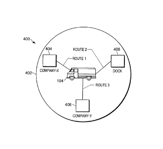
[0037] FIG. 4 illustrates the commercial motor vehicle 104 operating within a
geo-fenced
region 402, in accordance with some embodiments. As shown in FIG. 4, the geo-
fenced
region 402 includes three customer locations namely company-X 404, company-Y
406, and a
dock 408 that is used during loading and unloading of the commercial motor
vehicle 104.
Typically, a scheduler (either manually or using a computer application) would
schedule
drivers to service (or travel to) the three locations based on their
availability. FIG. 4 also
shows several routes that the commercial motor vehicle 104 can take. These
include Route 1
to company-X 404, Route 2 to the dock 408, and Route 3 to Company-Y 406.
[0038] According to FMCSA, "On-duty time" is defined as time from when a
driver begins
or is required to be in readiness for work until the time the driver is
relieved from work and
all responsibilities for performing work. Performing other compensated work
for a person
who is not a motor carrier is also on-duty time. "Driving time" is defined as
all time spent at
the driving controls of a commercial motor vehicle in operation. If a driver
is seated at the
driving controls of the vehicle, is able to simultaneously perform the driving
and auxiliary
function (for example, one hand on the steering wheel and one hand on a
control mechanism),
the time spent performing the auxiliary function muse be recorded as "Driving
time." If a
driver, seated at the driving controls of the vehicle, is unable to
simultaneously perform the
driving and auxiliary function, the time spent performing the auxiliary
function may be
recorded as "On-duty Not Driving time". The time spent in the vehicle would be
considered
as being in "on-duty status" (not driving) if a driver is dispatched to
another job once he/she
11
CA 3011530 2018-07-17
=
reaches a first terminal, and is in "off-duty status" if he/she is given 8
consecutive hours "off-
duty time" upon reaching the terminal. "Off-duty time" is any time that the
driver is not in
"driving status," "on-duty status," or "sleeper berth status." A driver may
use a sleeper berth
in the vehicle to rest and this time would be considered as "sleeper berth
time."
[0039] The systems and methods described herein provide a mechanism to
calculate the
historical averages of the time taken to service each of these locations and
determine if any of
the three locations will likely cause the driver to violate his/her hours-of-
service limits.
[0040] The type of hours-of-service analysis provided herein assists a
customer determine as
to which customers are more efficient at releasing their drivers so they can
chose the most
cost-effective customers. The route planning system 100 is capable of
analyzing the
locations where the drivers spend the least "On-duty time," which would be an
indicator that
their drivers are able to spend most of their time diving instead of waiting.
[0041] The system and methods provided herein uses a combination of databases
(for
example, geo-fence activity database 302, and hours-of-service activity
database 304) to
calculate the average time that previous drivers have spent within the geo-
fenced region 402
for various hours-of-service (HoS) duty classifications, namely: "off-duty
status," "off-duty
wellsite status," "sleeper berth status," "driving status," and "on-duty
status" With the
various historical averages available for several drivers and routes, the
route planning system
100 is able to predict the expected effect that characteristics within a geo-
fence will have on a
route or job that is to be scheduled.
[0042] FIG. 5 illustrates the method 500 for planning routes based on
historical activity, in
accordance with some embodiments. At block 504, the method 500 receives geo-
fence
activity from the geo-fence activity database 302. The geo-fence activity
database 302 stores
in a record 502 the activities (for example, entry into and exit out of the
geo-fenced region
402) of "User 1" within the geo-fence region 402. As shown in FIG. 5, the
record 502 shows
that "User 1" enters geo-fence at "6.00 AM" and exits the geo-fence at "7.00
AM." At block
508, the method 500 receives hours-of-service times from the hours-of-service
activity
database 304. The hours-of-service activity database 304 stores in a record
504 the hour-of-
service times (for example, times associated with "off-duty status," "on-duty
status," etc.).
For example, the record 504 shows that the "User 1" began "off-duty status" at
"5.00 AM,"
12
CA 3011530 2018-07-17
¨ _
and switched to "on-duty status" at "6.00 AM," began "driving status" at "6.30
AM," and
resumed "off-duty status" at "8.00 AM."
[0043] At block 510, the method 500 calculates a geo-fence activity time that
"User 1"
spends with the geo-fenced region 402 according to the various classifications
of status
stipulated by the FMCSA. For example, based on the data present in the record
502 and the
record 504 (shown in FIG. 5), the method 500 calculates that "User 1" has been
in "on-duty
status" for 0.5 hours; "sleeper berth status" for 0 hours; "driving status"
for 0.5 hours; "off-
duty status" for 0 hours; and "off-duty wellsite status" for 0 hours.
[0044] FIG. 6 is a flow chart illustrating a method 600 for planning routes
based on historical
activity within the geo-fenced region 402, in accordance with some
embodiments.
[0045] At block 610, the method 600 includes receiving, with an electronic
processor 204,
geo-fence data associated with a user of the vehicle 104 entering a geo-fenced
region 402 and
exiting out of the geo-fenced region 402. For example, "User 1" enters the geo-
fenced region
402 at 6AM and exits the geo-fenced region 402 at 7 AM (as shown in FIG. 5).
[0046] At block 620, the method 600 includes receiving, with the electronic
processor 204,
the hours-of-service data associated with the user of the vehicle 104. For
example, the hours-
of-service data includes "User 1" entering "off-duty status" at 5 AM, entering
"on-duty
status" at 6 AM, entering "driving" status at 6.30 AM, and entering "off-duty
status" at 8 AM
(as shown in FIG, 5).
[0047] At block 630, the method 600 includes determining, with the electronic
processor 204,
the geo-fence activity time (for example, the time spent in one or more of the
following
statuses, such as "off-duty status," "off-duty Wellsite status," "sleeper
berth status," "driving
status," and "on-duty status") associated with the user of the vehicle 104
based on the geo-
fence data. For example, "User 1" spends) 0.5 hours in "on-duty status," 0
hours in "sleeper
berth status," 0.5 hours in "driving status," 0 hours in "off-duty status,"
and 0 hours in "off-
duty Wellsite status" (as shown in FIG. 5).
[0048] At block 640, the method 600 includes determining, with the electronic
processor 204,
an available time for the user of the vehicle 104 based on the hours-of-
service data and the
geo-fence activity time. In some embodiments the hours-of-service data and the
geo-fence
activity time is associated with at least one selected from the group
consisting of off-duty
13
CA 3011530 2018-07-17
=
status, off-duty wellsite status, sleeper berth status, driving status, and on-
duty status. In
some embodiments, the method 600 includes determining, with the electronic
processor 204,
an average time associated with the duty status for a plurality of previous
users inside the
geo-fenced region 402.
[0049] For example, assume that a driver has 2 hours of "driving time" left
and 4 hours of
"on-duty time" remaining based on their hours-of-service limits. Additionally,
the geo-fence
activity database 302 has captured the following activities for various
drivers within the geo-
fenced region 402.
Route 1 to Company-X 404: Drivers to this location typically spend 1 hour of
"drive
time" and 2 hours of "on-duty time."
Route 2 to Dock 408: Drivers to this location typically spend 3 hours of
"drive time"
because of traffic at dock 408.
Route 3 to Company-Y 406: Drivers to this location typically spend 1 hour of
"drive
time" and only 2 hours of "on-duty" time because they spend 2 hours of "off-
duty" time at a
nearby restaurant.
[0050] Previously, the scheduler would have only known that the driver
scheduled for a job
at dock 408 would typically spends 3 hours at a location based on the timing
corresponding to
GPS coordinates associated with the CMV at various locations within the geo-
fenced region
402. On the other hand, systems and methods provided herein determines that
the driver
would spend most of their time in "drive time," which would cause a violation
of the FMCSA
regulations.
[0051] At block 650, the method 600 includes generating, with the electronic
processor 204,
a route for the vehicle 104 based on the available time. In the example shown
above, the
route planning system 100 will be able to select the company-X 404 (which
required only I
hour "drive time") as the next job location for this particular driver who
still has 2 hours of
"Drive time" remaining. The method 600 includes determining, with the
electronic processor
204, that the user of the vehicle 104 does not violate an hours-of-service
requirement when
choosing a particular job.
14
CA 3011530 2018-07-17
[0052] Additionally, if the driver is using a non-consecutive hours-of-service
rule set, the
route planning system 100 would be able to recommend company-Y 406 as an
option as
compared to before when this option might not have been considered because it
seems like
drivers spend 5 total hours there without the information that 2 hours there
was spent as "Off
duty time."
[0053] In the foregoing specification, specific embodiments have been
described. However,
one of ordinary skill in the art appreciates that various modifications and
changes can be
made without departing from the scope of the invention as set forth in the
claims below.
Accordingly, the specification and figures are to be regarded in an
illustrative rather than a
restrictive sense, and all such modifications are intended to be included
within the scope of
present teachings.
[0054] The benefits, advantages, solutions to problems, and any element(s)
that may cause
any benefit, advantage, or solution to occur or become more pronounced are not
to be
construed as a critical, required, or essential features or elements of any or
all the claims. The
invention is defined solely by the appended claims including any amendments
made during
the pendency of this application and all equivalents of those claims as
issued.
[0055] Moreover in this document, relational terms such as first and second,
top and bottom,
and the like may be used solely to distinguish one entity or action from
another entity or
action without necessarily requiring or implying any actual such relationship
or order
between such entities or actions. The terms "comprises," "comprising," "has",
"having,"
"includes", "including," "contains", "containing" or any other variation
thereof, are intended
to cover a non-exclusive inclusion, such that a process, method, article, or
apparatus that
comprises, has, includes, contains a list of elements does not include only
those elements but
may include other elements not expressly listed or inherent to such process,
method, article,
or apparatus. An element proceeded by "comprises ...a", "has ...a", "includes
...a",
"contains ...a" does not, without more constraints, preclude the existence of
additional
identical elements in the process, method, article, or apparatus that
comprises, has, includes,
contains the element. The terms "a" and "an" are defined as one or more unless
explicitly
stated otherwise herein. The terms "substantially", "essentially",
"approximately", "about"
or any other version thereof, are defined as being close to as understood by
one of ordinary
CA 3011530 2018-07-17
skill in the art, and in one non-limiting embodiment the term is defined to be
within 10%, in
another embodiment within 5%, in another embodiment within 1% and in another
embodiment within 0.5%. The term "coupled" as used herein is defined as
connected,
although not necessarily directly and not necessarily mechanically. A device
or structure that
is "configured" in a certain way is configured in at least that way, but may
also be configured
in ways that are not listed.
[0056] It will be appreciated that some embodiments may be comprised of one or
more
generic or specialized processors (or "processing devices") such as
microprocessors, digital
signal processors, customized processors and field programmable gate arrays
(FPGAs) and
unique stored program instructions (including both software and firmware) that
control the
one or more processors to implement, in conjunction with certain non-processor
circuits,
some, most, or all of the functions of the method and/or apparatus described
herein.
Alternatively, some or all functions could be implemented by a state machine
that has no
stored program instructions, or in one or more application specific integrated
circuits (ASICs),
in which each function or some combinations of certain of the functions are
implemented as
custom logic. Of course, a combination of the two approaches could be used.
[0057] Moreover, an embodiment can be implemented as a computer-readable
storage
medium having computer readable code stored thereon for programming a computer
(e.g.,
comprising a processor) to perform a method as described and claimed herein.
Examples of
such computer-readable storage mediums include, but are not limited to, a hard
disk, a CD-
ROM, an optical storage device, a magnetic storage device, a ROM (Read Only
Memory), a
PROM (Programmable Read Only Memory), an EPROM (Erasable Programmable Read
Only Memory), an EEPROM (Electrically Erasable Programmable Read Only Memory)
and
a Flash memory. Further, it is expected that one of ordinary skill,
notwithstanding possibly
significant effort and many design choices motivated by, for example,
available time, current
technology, and economic considerations, when guided by the concepts and
principles
disclosed herein will be readily capable of generating such software
instructions and
programs and ICs with minimal experimentation.
[0058] The Abstract of the Disclosure is provided to allow the reader to
quickly ascertain the
nature of the technical disclosure. It is submitted with the understanding
that it will not be
16
CA 3011530 2018-07-17
_ ¨
used to interpret or limit the scope or meaning of the claims. In addition, in
the foregoing
Detailed Description, it can be seen that various features are grouped
together in various
embodiments for the purpose of streamlining the disclosure. This method of
disclosure is not
to be interpreted as reflecting an intention that the claimed embodiments
require more
features than are expressly recited in each claim. Rather, as the following
claims reflect,
inventive subject matter lies in less than all features of a single disclosed
embodiment. Thus
the following claims are hereby incorporated into the Detailed Description,
with each claim
standing on its own as a separately claimed subject matter.
17
CA 3011530 2018-07-17