Note: Descriptions are shown in the official language in which they were submitted.
CA 03019434 2018-09-28
WO 2017/165947
PCT/CA2016/000097
METHOD AND SYSTEMS FOR REMOVING THE MOST
EXTRANEOUS DATA RECORD FROM A REMOTE REPOSITORY
Technical field
[0001] The present invention relates to an interactive computer
simulations and, more
particularly, to data management during interactive computer simulations.
Background
[0002] Interactive computer simulation systems are used to train
personnel on complex
and/or risky tasks. The interactive computer simulation allows a user to
interact in a computer
generated environment by controlling a simulated system (e.g., an aircraft, a
ground vehicle, a
space station, etc.). In order to provide a realistic and meaningful
experience to the users of the
interactive computer simulation. Simulated systems and computer environments
tend to
become more complex and/or are simulated in a more complex and thorough
manner, which
leads to an increase in the required amount of data. The amount of data
required is such that an
isolated computer system would have to be dimensioned unreasonably to be able
to cope with
it. Furthermore, when the computer generated environment needs to be modified,
it is
advantageous to update one or a few network locations serving many distributed
simulation
systems. However, when the data is distributed over a network, quality of
service becomes a
big challenge (e.g., network delay and limited bandwidth may affect the user
experience). For
instance, the behavior of a simulated airplane needs to be plausible and
sufficiently predictable
in the computer generated environment considering simulated conditions and
commands from
the user in the simulator, which requires access to a large amount of data.
[0003] The present invention addresses data management considerations in
the context of
interactive computer simulation systems.
Summary
[0004] This summary is provided to introduce a selection of concepts in a
simplified form
that are further described below in the Detailed Description. This Summary is
not intended to
identify key features or essential features of the claimed subject matter, nor
is it intended to be
used as an aid in determining the scope of the claimed subject matter.
1
CA 03019434 2018-09-28
WO 2017/165947
PCT/CA2016/000097
[0005] In
accordance with a first set of embodiments, a first aspect is directed to a
remote
'data management system for supporting an interactive computer simulation
system that
executes an interactive computer simulation. The remote data management system
comprises a
network interface module, a data storage system and a processor module.
[0006] The network interface module provides network access towards a
central
repository for storing a synthetic natural environment database that comprises
data for a
plurality of geographically-located terrain skin representations of a computer
generated
environment. The network interface module also provides network access towards
a plurality
of interactive computer simulation stations, each one of the plurality of
interactive computer
simulation stations allowing one or more users to interact in the interactive
computer
simulation for controlling a vehicle in the computer generated environment
thereof
[0007]
The data storage system comprises a remote repository accessible through the
network interface module for storing a subset of the synthetic natural
environment database.
The remote repository is accessible to a first simulation station of the
plurality of interactive
simulation stations.
[0008]
The processor module that computes a plurality of expected geographical
positions
for the first simulation station and anticipatorily updates, via the network
interface module, the
subset of the synthetic natural environment database stored in the remote
repository with a
supplemental subset of the synthetic natural environment database
corresponding to one or
.. more of the computed expected geographical positions.
[0009]
Optionally, the supplemental subset of the synthetic natural environment
database
corresponds to geographical positions missing therefrom. The processor module
may then
further monitor remaining storage capacity of the remote repository and
perform the
anticipatory update until reaching a high-level remaining capacity threshold.
[0010] The processor module may also optionally compute the plurality of
expected
geographical positions by, in non-real-time priority processing, computing a
training schedule
for the first simulation station having one or more associated training
scenarios that include
the plurality of expected geographical positions.
[0011] In
some embodiments, the processor module may compute the plurality of
expected geographical positions by i) in real-time priority processing during
execution of the
interactive computer simulation, computing a vector from past update requests
from the first
2
CA 03019434 2018-09-28
WO 2017/165947
PCT/CA2016/000097
simulation station before computing therefrom the plurality of expected
geographical
positions, ii) in real-time priority processing during execution of the
interactive computer
simulation, computing a training scenario for the interactive computer
simulation that includes
the plurality of expected geographical positions, iii) in real-time priority
processing during
execution of the interactive computer simulation, computing a vector from past
update data-
resolution-increase requests from the first simulation station before
computing therefrom the
plurality of expected geographical positions, iv) in non-real-time priority
processing,
computing updates to the computer generated environment at the plurality of
expected
geographical positions and/or v) in real-time priority processing, computing
updates to the
computer generated environment at the plurality of expected geographical
positions.
[0012]
The synthetic natural environment database may further comprise navigation
content related to more than one vehicles in the computer generated
environment and the
processor module may then compute the plurality of expected geographical
positions
considering the navigation content from the perspective of the first
simulation station.
[0013] The processor module may also optionally compute the plurality of
expected
geographical positions by further considering a subset of data types
associated with a plurality
of data consumers from the first simulation station. The processor module may
yet also update
the subset at the remote repository considering priority tags associated
therewith.
[0014] In
accordance with the first set of embodiments, a second aspect is directed to a
method for supporting an interactive computer simulation system that executes
an interactive
computer simulation on a first simulation station allowing one or more users
to interact in the
interactive computer simulation for controlling a simulated vehicle in a
computer generated
environment thereof. The method comprises providing access towards a central
repository
comprising a synthetic natural environment database that comprises data for a
plurality of
geographically-located terrain skin representations of the computer generated
environment of
the interactive computer simulation. The method also comprises, at a remote
data management
system, computing a plurality of expected geographical positions for the first
simulation
station; and, from the remote data management system, anticipatorily updating,
via the
network, a subset of the synthetic natural environment database stored in a
remote repository
accessible to the first simulation station with a supplemental subset of the
synthetic natural
environment database corresponding to one or more of the computed expected
geographical
positions.
3
CA 03019434 2018-09-28
WO 2017/165947
PCT/CA2016/000097
[0015] The method may optionally further comprise monitoring remaining
storage
'capacity of the remote repository and the supplemental subset of the
synthetic natural
environment database may then correspond to geographical positions missing
therefrom.
Anticipatorily updating may also optionally be performed until reaching a high-
level
remaining capacity threshold.
[0016] The synthetic natural environment database may further comprise
navigation
content related to more than one vehicles in the computer generated
environment and
computing the plurality of expected geographical positions may then further
comprise
considering the navigation content from the perspective of the first
simulation station.
[0017] The remote repository may also be further accessible to a second
simulation
station of the plurality of interactive simulation stations and computing the
plurality of
expected geographical positions may then be performed for the first and the
second simulation
stations. A proximate repository, between the remote repository and the first
simulation
station, may optionally be dedicated to the first simulation station and
accessible to the remote
repository for storing a proximate subset of the synthetic natural environment
database smaller
than the subset stored in the remote repository. The method may optionally
further comprise,
from the remote repository or from the proximate repository, computing a
plurality of
proximate expected geographical positions for the first simulation station and
anticipatorily
updating the proximate subset with a supplemental proximate subset of the
synthetic natural
environment database corresponding to one or more of the computed proximate
expected
geographical positions. The method may also further comprise executing a local
interactive
computer simulation application that strictly accesses the proximate
repository via the network
for displaying images in relation to the computer generated environment of the
interactive
computer simulation.
[0018] In accordance with the first set of embodiments, a second aspect is
directed to a
system, for executing an interactive computer simulation of a simulated
vehicle, comprising a
central repository, a remote data management system, a remote repository and
an interactive
computer simulation station interconnected via a network. The central
repository comprises a
synthetic natural environment database that comprises data for a plurality of
geographically-
located terrain skin representations of a computer generated environment of
the interactive
computer simulation. The remote data management system maintains the remote
repository
comprising a subset of the synthetic natural environment database accessible
to the interactive
computer simulation station. The interactive computer simulation station
sends, over the
4
CA 03019434 2018-09-28
WO 2017/165947
PCT/CA2016/000097
network, a data request for one or more geographical locations from the
synthetic natural
'environment database for rendering images for the interactive computer
simulation and allows
one or more users to interact in the interactive computer simulation for
controlling the
simulated vehicle in the computer generated environment considering the
rendered images.
The remote data management system of the interactive computer simulation
system computes
a plurality of expected geographical positions for the first simulation
station interactive
computer simulation stations and anticipatorily updates, via the network, the
subset of the
synthetic natural environment database stored in the remote repository with a
supplemental
subset of the synthetic natural environment database corresponding to one or
more of the
computed expected geographical positions.
100191
The remote data management system may optionally further monitor remaining
storage capacity of the remote repository and the supplemental subset of the
synthetic natural
environment database may then correspond to geographical positions missing
therefrom. The
anticipatorily update may optionally be performed until reaching a high-level
remaining
capacity threshold.
100201
The system may optionally further comprise a second interactive computer
simulation station having access to the remote repository via the network. The
remote data
management system may then compute the plurality of expected geographical
positions for the
interactive computer simulation station and the second interactive computer
simulation station.
The system may yet further comprise a proximate repository, between the remote
repository
and the interactive computer simulation station dedicated thereto, accessible
to the remote
repository for storing a proximate subset of the synthetic natural environment
database smaller
than the subset stored in the remote repository. The remote repository or the
proximate
repository may then further compute a plurality of proximate expected
geographical positions
.. for the interactive computer simulation station and anticipatorily update
the proximate subset
with a supplemental proximate subset of the synthetic natural environment
database
corresponding to one or more of the computed proximate expected geographical
positions. The
system may further comprise a second proximate repository, between the remote
repository
and the second interactive computer simulation station dedicated thereto,
accessible to the
remote repository for storing a second proximate subset of the synthetic
natural environment
database smaller than the subset stored in the remote repository. The remote
repository or the
second proximate repository may then further compute a plurality of second
proximate
expected geographical positions for the second interactive computer simulation
station and
5
CA 03019434 2018-09-28
WO 2017/165947
PCT/CA2016/000097
anticipatorily update the second proximate subset with a second supplemental
proximate
=
subset of the synthetic natural environment database corresponding to one or
more of the
computed second proximate expected geographical positions.
[0021] The proximate repository and the second proximate repository may
optionally
strictly access the remote repository via the network for respectively
complementing the
proximate subset and the second proximate subset and the remote repository may
strictly
access the central repository for complementing the subset.
[0022] In accordance with a second set of embodiments, a first aspect is
directed to a
remote data management system for supporting an interactive computer
simulation system that
.. executes an interactive computer simulation. The remote data management
system comprises a
network interface module, a data storage system and a processor module.
[0023] The network interface module provides network access towards a
central
repository for storing a synthetic natural environment database that comprises
data of a
plurality of data types for a plurality of geographically-located terrain skin
representations of a
computer generated environment of the interactive computer simulation. The
network
interface module also provides network access towards an interactive computer
simulation
station participating in the interactive computer simulation. The computer
simulation stations
allow one or more users to interact in the interactive computer simulation for
controlling a
vehicle in the computer generated environment, wherein the interactive
computer simulation
station comprising a plurality of data consumers each requiring data from one
or more of the
plurality of data types.
[0024] The data storage system comprises a remote repository for storing
a subset of the
synthetic natural environment database.
[0025] The processor module, upon receipt of a data request from the
interactive
computer simulation station for one or more geographical locations, determines
a set of data
types considering one or more requesting data consumers from the plurality of
data consumers
and updates the subset of the synthetic natural environment database in the
remote repository
for the one or more geographical locations with data of only the set of data
types.
[0026] Optionally, the plurality of data types may comprise rendering-
faces data, surface-
texture data and reflectivity data. The plurality of data consumers may
comprise a radar
6
CA 03019434 2018-09-28
WO 2017/165947
PCT/CA2016/000097
system requiring rendering faces data and reflectivity data and a visual
display system
requiring rendering faces data and surface texture data.
[0027] The set of data types may optionally be determined by a logical
union operation of
required data types from the one or more requesting data consumers.
[0028] Optionally, the processor module may compute a plurality of expected
geographical positions for the interactive computer simulation station and
monitor remaining
storage capacity of the remote repository. Updating the subset may then be
performed for one
or more of the expected geographical positions until reaching a high-level
remaining capacity
threshold.
[0029] The synthetic natural environment database may further comprise
navigation
content related to more than one vehicles in the computer generated
environment and the
processor module may then determine the set of data types considering the
navigation content
from the perspective of the interactive computer simulation station.
[0030] The processor module may optionally update the subset at the
remote repository
considering priority tags associated therewith.
[0031] In accordance with the second set of embodiments, a second aspect
is directed to a
method for supporting an interactive computer simulation system that executes
an interactive
computer simulation. The method comprises providing access towards a central
repository that
stores a synthetic natural environment database that comprises data of a
plurality of data types
for a plurality of geographically-located terrain skin representations of a
computer generated
environment of the interactive computer simulation and receiving, over a
network, a data
request issued from an interactive computer simulation station for one or more
geographical
locations. The interactive computer simulation station allows one or more
users to interact in
the interactive computer simulation for controlling a vehicle in the computer
generated
environment. The interactive computer simulation station comprises a plurality
of data
consumers each requiring data from one or more of the plurality of data types.
The method
also comprises determining a set of data types considering one or more
requesting data
consumers from the plurality of data consumers and updating, over the network,
a subset of
the synthetic natural environment database stored in a remote repository for
the one or more
geographical locations with data of only the set of data types. The remote
repository is
accessible to the interactive computer simulation station.
7
CA 03019434 2018-09-28
WO 2017/165947
PCT/CA2016/000097
[0032] Optionally, the plurality of data types may comprise rendering-
faces data, surface-
'texture data and reflectivity data. The plurality of data consumers may
further comprise a radar
system requiring rendering faces data and reflectivity data and a visual
display system
requiring rendering faces data and surface texture data.
[0033] Determining the set of data types may optionally be performed by a
logical union
operation of required data types from the one or more requesting data
consumers.
[0034] The method may further comprise computing a plurality of expected
geographical
positions for the interactive computer simulation station and monitoring
remaining storage
capacity of the remote repository. Updating the subset may then be performed
for one or more
.. of the expected geographical positions until reaching a high-level
remaining capacity
threshold.
[0035] The synthetic natural environment database may optionally further
comprise
navigation content related to more than one vehicles in the computer generated
environment
and determining the set of data types may then be performed considering the
navigation
content from the perspective of the interactive computer simulation station.
[0036] Updating the subset at the remote repository may optionally be
performed
considering priority tags associated therewith.
[0037] In accordance with the second set of embodiments, a third aspect
is directed to a
system, for executing an interactive computer simulation of a simulated
vehicle, comprising a
central data management system, a central repository, a remote repository and
an interactive
computer simulation station interconnected via a network. The central
repository comprises a
synthetic natural environment database that comprises data of a plurality of
data types for
representing a plurality of geographically-located terrain skin
representations of a computer
generated environment of the interactive computer simulation.
[0038] The remote data management system of the interactive computer
simulation
system maintain the remote repository storing a subset of the synthetic
natural environment
database.
[0039] The interactive computer simulation station comprises a plurality
of data
consumers each requiring data from one or more of the plurality of data types,
sends, over the
network, a data request for one or more geographical locations from the
synthetic natural
8
CA 03019434 2018-09-28
WO 2017/165947
PCT/CA2016/000097
environment database for rendering images for the interactive computer
simulation and allows
one or more users to interact in the interactive computer simulation for
controlling the
simulated vehicle in the computer generated environment considering the
rendered images
[0040]
The remote data management system of the interactive computer simulation
system determines a set of data types considering one or more requesting data
consumers from
the data request and updates, over the network, the subset of the synthetic
natural environment
database stored in the remote repository for the one or more geographical
locations with data
of only the set of data types.
[0041]
The remote data management system of the interactive computer simulation
system may further compute a plurality of expected geographical positions for
the interactive
computer simulation station, monitor remaining storage capacity of the remote
repository and
update the subset in the remote repository for one or more of the expected
geographical
positions until reaching a high-level remaining capacity threshold.
[0042]
The system may optionally further comprise a second interactive computer
simulation station having access to the remote repository via the network. The
remote data
management system may then determine the set of data types considering one or
more
requesting data consumers from the plurality of data consumers and one or more
second
requesting data consumers from a second plurality of data consumers of the
second interactive
computer simulation station.
[0043] The system may further optionally comprise a proximate repository,
between the
remote repository and the interactive computer simulation station dedicated
thereto, accessible
to the remote repository for storing a proximate subset of the synthetic
natural environment
database smaller than the subset stored in the remote repository. The remote
repository or the
proximate repository may further determine a set of proximate data types
considering one or
more requesting data consumers from the plurality of data consumers and
remotely updates,
over the network, the proximate subset of the synthetic natural environment
database stored in
the proximate repository for the one or more geographical locations with data
of only the set
of data types.
[0044]
Optionally, the system may also further comprise a second proximate
repository,
between the remote repository and the second interactive computer simulation
station
dedicated thereto, accessible to the remote repository for storing a second
proximate subset of
the synthetic natural environment database smaller than the subset stored in
the remote
9
CA 03019434 2018-09-28
WO 2017/165947
PCT/CA2016/000097
repository. The remote repository or the second repository may then further
determine a
second set of proximate data types considering the one or more second
requesting data
consumers from the second plurality of data consumers and remotely update,
over the
network, the second proximate subset of the synthetic natural environment
database stored in
the second proximate repository for the one or more geographical locations
with data of only
the second set of data types.
[0045]
The proximate repository and the second proximate repository may optionally
strictly access the remote repository via the network for respectively
complementing the
proximate subset and the second proximate subset and the remote repository may
likewise
strictly access the central repository for complementing the subset.
[0046] In
accordance with a third set of embodiments, a first aspect is directed to a
remote
data management system for supporting an interactive computer simulation
system that
executes an interactive computer simulation. The remote data management system
comprises
network interface module, data storage system and a processor module.
[0047] The central repository is for storing a synthetic natural
environment database that
comprises a plurality of data records for a plurality of geographically-
located terrain skin
representations of the computer generated environment. The network interface
module also
provides network access towards a plurality of interactive computer simulation
stations, each
one of the plurality of interactive computer simulation stations allowing one
or more users to
interact in the interactive computer simulation for controlling a vehicle in
the computer
generated environment thereof
[0048]
The data storage system comprises a remote repository accessible through the
network interface module for storing a subset of data records from the
synthetic natural
environment database. One of a plurality of priority tags is associated with
each one of the
subset of data records and the remote repository is accessible to the
plurality of interactive
simulation stations.
[0049]
The processor module monitors remaining storage capacity of the remote
repository and, upon reaching a high-level threshold value for the remaining
storage capacity,
removes, via the network interface module, the most extraneous data record,
identified
considering one or more of the plurality of priority tags, from the subset of
data records stored
in the remote repository until reaching a low-level threshold value for the
remaining storage
capacity.
CA 03019434 2018-09-28
WO 2017/165947
PCT/CA2016/000097
[0050]
The processor module may optionally identify the most extraneous data record
as a
top data record from a priority-ordered target list for the subset of data
records in the remote
repository considering the plurality of priority tags. Removing the most
extraneous data record
may then be performed by removing the top data record from the target list
until reaching a
low-level threshold value for the remaining storage capacity. Each one of the
plurality of
priority tags may comprise a time-based indication for obtaining a
corresponding relative
record age and a record-insertion-method indication. The record-insertion-
method indication
may be considered before considering the time-based indication for ordering
the target list.
The record-insertion-method indication may be one of "requested from
simulation" and
"predicted from repository", and the target list may order all the "predicted
from repository"
records at the top followed by all the "requested from simulation" records by
age with the
oldest towards the top. The "predicted from repository" indication may further
orderly contain
"geographic predicted", "sub-data-type" and "best-guess" indications.
[0051]
Each one of the plurality of priority tags may further comprise a "number of
requestors" indication considered before the time-based indication for
ordering the target list.
[0052] In
accordance with the third set of embodiments, a second aspect is directed to a
method for supporting an interactive computer simulation system that executes
an interactive
computer simulation. The method comprises providing access towards a central
repository that
stores a synthetic natural environment database that comprises a plurality of
data records for a
plurality of geographically-located terrain skin representations of a computer
generated
environment. The method also comprises maintaining a remote repository
accessible through a
network for storing a subset of data records from the synthetic natural
environment database.
Each one of a plurality of priority tags is associated with each one of the
subset of data
records. The remote repository is accessible through the network to a
plurality of interactive
computer simulation stations, each one of the plurality of interactive
computer simulation
stations allowing one or more users to interact in the interactive computer
simulation for
controlling a vehicle in the computer generated environment thereof.
[0053]
The method also comprises monitoring remaining storage capacity of the remote
repository and, upon reaching a high-level threshold value for the remaining
storage capacity,
removing, via the network, the most extraneous data record, identified
considering one or
more of the plurality of priority tags, from the subset of data records stored
in the remote
repository until reaching a low-level threshold value for the remaining
storage capacity.
11
CA 03019434 2018-09-28
WO 2017/165947
PCT/CA2016/000097
[0054]
The method may further comprise identifying the most extraneous data record as
a
,
top data record from a priority-ordered target list for the subset of data
records in the remote
repository considering the plurality of priority tags. Removing the most
extraneous data record
may then be performed by removing the top data record from the target list
until reaching a
low-level threshold value for the remaining storage capacity.
[0055]
Optionally, each one of the plurality of priority tags may comprise a time-
based
indication for obtaining a corresponding relative record age and a record-
insertion-method
indication. The record-insertion-method indication may then be considered
before considering
the time-based indication for ordering the target list. The record-insertion-
method indication
may be one of "requested from simulation" and "predicted from repository", and
the target list
may order all the "predicted from repository" records at the top followed by
all the "requested
from simulation" records by age with the oldest towards the top. The
"predicted from
repository" indication may further orderly contain "geographic predicted",
"sub-data-type"
and "best-guess".
[0056] Optionally, each one of the plurality of priority tags may further
comprise a
"number of requestors" indication considered before the time-based indication
for ordering the
target list.
[0057] In
accordance with the third set of embodiments, a third aspect is directed to a
system, for executing an interactive computer simulation of a simulated
vehicle, comprising a
central data management system, a central repository, a remote repository and
an interactive
computer simulation station interconnected via a network.
[0058]
The central repository stores a synthetic natural environment database that
comprises a plurality of data records for a plurality of geographically-
located terrain skin
representations of a computer generated environment.
[0059] The remote data management system of the interactive computer
simulation
system maintains the remote repository storing a subset of data records from
the synthetic
natural environment database. Each one of a plurality of priority tags is
associated with each
one of the subset of data records.
[0060]
The interactive computer simulation station sends, over the network, a data
request
for one or more geographical locations from the synthetic natural environment
database for
rendering images for the interactive computer simulation and allows one or
more users to
12
CA 03019434 2018-09-28
WO 2017/165947
PCT/CA2016/000097
interact in the interactive computer simulation for controlling the simulated
vehicle in the
computer generated environment considering the rendered images.
[0061] The remote data management system of the interactive computer
simulation
system monitors remaining storage capacity of the remote repository and, upon
reaching a
high-level threshold value for the remaining storage capacity, removes, via
the network, the
most extraneous data record, identified considering one or more of the
plurality of priority
tags, from the subset of data records stored in the remote repository until
reaching a low-level
threshold value for the remaining storage capacity.
[0062] The most extraneous data record may optionally be identified as
the top data
.. record from a priority-ordered target list for the subset of data records
in the remote repository
considering the plurality of priority tags and the most extraneous data record
may then be
removed by removing the top data record from the target list until reaching a
low-level
threshold value for the remaining storage capacity. Each one of the plurality
of priority tags
may further comprise a time-based indication for obtaining a corresponding
relative record age
and a record-insertion-method indication and the record-insertion-method
indication may then
be considered before considering the time-based indication for ordering the
target list. The
record-insertion-method indication may further be one of "requested from
simulation" and
"predicted from repository", and wherein the target list orders all the
"predicted from
repository" records at the top followed by all the "requested from simulation"
records by age
with the oldest towards the top.
[0063] The system may further optionally comprise a second interactive
computer
simulation station having access to the remote repository via the network.
Each one of the
plurality of priority tags may then further comprise a "number of requestors"
indication
considered before the time-based indication for ordering the target list.
[0064] The system may also optionally comprise a proximate repository,
between the
remote repository and the interactive computer simulation station dedicated
thereto, accessible
to the remote repository for storing a proximate subset of the synthetic
natural environment
database smaller than the subset stored in the remote repository. The remote
repository or the
proximate repository may further monitor proximate remaining storage capacity
of the
proximate repository and, upon reaching a high-level threshold value for the
proximate
remaining storage capacity, remove (remotely or locally), via the network, the
most extraneous
data record, identified considering one or more of the plurality of priority
tags, from the
13
CA 03019434 2018-09-28
WO 2017/165947
PCT/CA2016/000097
proximate subset of data records stored in the proximate repository until
reaching a low-level
threshold value for the proximate remaining storage capacity.
[0065] The system may yet further comprise a second proximate
repository, between the
remote repository and the second interactive computer simulation station
dedicated thereto,
accessible to the remote repository for storing a second proximate subset of
the synthetic
natural environment database smaller than the subset stored in the remote
repository. The
remote repository or the second proximate repository may then further monitor
second
proximate remaining storage capacity of the second proximate repository and,
upon reaching a
high-level threshold value for the second proximate remaining storage
capacity, remove
(remotely or locally), via the network, the most extraneous data record,
identified considering
one or more of the plurality of priority tags, from the second proximate
subset of data records
stored in the second proximate repository until reaching a low-level threshold
value for the
second proximate remaining storage capacity.
[0066] The proximate repository and the second proximate repository may
optionally
strictly access the remote repository via the network for respectively
complementing the
proximate subset and the second proximate subset and the remote repository
strictly may
likewise access the central repository for complementing the subset.
Brief description of the drawings
[0067] Further features and exemplary advantages of the present
invention will become
apparent from the following detailed description, taken in conjunction with
the appended
drawings, in which:
[0068] Figure 1 is a first logical representation of an exemplary
computer system in
accordance with the teachings of the present invention;
[0069] Figure 2 is a second logical representation of the exemplary
computer system in
accordance with the teachings of the present invention; and
[0070] Figure 3A, Figure 3B, Figure 4A, Figure 4B, Figure 5A and Figure
5B are flow
charts of exemplary methods in accordance with the teachings of the present
invention.
14
CA 03019434 2018-09-28
WO 2017/165947
PCT/CA2016/000097
Detailed description
[0071]
Reference is now made to the drawings in which Figure 1 shows a logical
modular
view of an exemplary interactive computer simulation system 1000 in accordance
with the
teachings of the present invention. The interactive computer simulation system
1000 performs
one or more interactive computer simulations. Each interactive computer
simulation comprises
one or more simulated systems such as simulated vehicles (simulated aircrafts,
simulated tanks
or ground vehicles, simulated marine vessel, etc.). In the depicted embodiment
of Figure 1, the
interactive computer simulation system 1000 comprises a remote data management
system
1100 for supporting the interactive computer simulation system 1000 when
executing the
interactive computer simulation(s). The interactive computer simulation system
1000 typically
comprises at least one simulation station 1200.1, but typically comprises a
plurality of
simulation stations 1200.1...1200.n. The plurality of simulation stations is
referred to together
as the simulation stations 1200 hereinafter. Each of the plurality of
simulation stations 1200
allows one or more users to interact to control a simulated system in a
computer generated
environment of the interactive computer simulation system 1000. The remote
data
management system 1100 and the simulation stations 1200 are depicted as being
interconnected via a network 1940. The network 1940 may be connected or may
provide
access to a network 1840. Skilled persons will readily understand that the
direct connections or
a mix of direct and network connections may be used to interconnect the remote
data
management system 1100 and the simulation stations 1200. Various network links
may be
implicitly or explicitly used in the context of the present invention. While a
link may be
depicted as a wired link (using a coaxial cable, an optical fiber, a category
5 cable, and the
like), it could also be embodied as a wireless link (using a cellular link, a
wireless LAN, and
the like). A wired or wireless access point (not shown) may be present on
links. Likewise, any
number of routers and/or switches (not shown) may be present on links, which
may further
transit through the Internet.
[0072] In
the depicted example of Figure 1, the remote data management system 1100
comprises a memory module 1120, a processor module 1130 and a network
interface module
1140. The processor module 1130 may represent a single processor with one or
more
processor cores or an array of processors, each comprising one or more
processor cores. The
memory module 1120 may comprise various types of memory (different
standardized or kinds
of Random Access Memory (RAM) modules, memory cards, Read-Only Memory (ROM)
modules, programmable ROM, etc.). The network interface module 1140 represents
at least
CA 03019434 2018-09-28
WO 2017/165947
PCT/CA2016/000097
one physical interface that can be used to communicate with other network
nodes. The
network interface module 1140 may be made visible to the other modules of the
computer
system 1100 through one or more logical interfaces. The actual stacks of
protocols used by the
physical network interface(s) and/or logical network interface(s) 1142, 1144,
1146, 1148 of
the network interface module 1140 do not affect the teachings of the present
invention. The
variants of processor module 1130, memory module 1120 and network interface
module 1140
usable in the context of the present invention will be readily apparent to
persons skilled in the
art.
[0073] A
bus 1170 is depicted as an example of means for exchanging data between the
different modules of the remote data management system 1100. The present
invention is not
affected by the way the different modules exchange information between them.
For instance,
the memory module 1120 and the processor module 1130 could be connected by a
parallel
bus, but could also be connected by a serial connection or involve an
intermediate module (not
shown) without affecting the teachings of the present invention.
[0074] Likewise, even though explicit mentions of the memory module 1120
and/or the
processor module 1130 are not made throughout the description of the various
embodiments,
persons skilled in the art will readily recognize that such modules are used
in conjunction with
other modules of the remote data management system 1100 to perform routine as
well as
innovative steps related to the present invention.
[0075] A distributed data storage system is also provided in the
interactive computer
simulation system 1000. In the example of Figure 1, a central repository 1500
stored a
synthetic natural environment database that comprises data for representing
geographically-
located terrain skin of the computer generated environment. For instance, the
terrain skin
representation would typically comprise material data and/or imagery data
and/or elevation
data for different areas of the terrain (e.g., a portion of the terrain
identified by a geographical
position has certain properties. The synthetic natural environment database
may also further
comprise geographically-located 3D polygon mesh data (buildings and structure
of the
computer generated environment) as well as vector data and metadata (e.g.,
default values on
common element). The central repository 1500 may also log dynamic data in
relation to the
different simulated systems while the interactive computer simulation is
performed (e.g.,
weather-related (such as clouds), modifications made by the simulated system
on the computer
generated environment, etc.). The remote data management system 1100 comprises
a remote
repository 1600 for storing a subset of the synthetic natural environment
database. The central
16
CA 03019434 2018-09-28
WO 2017/165947
PCT/CA2016/000097
repository 1500 is accessible by the remote data management system 1100
through the
network interface module 1140. The remote repository 1600 is also accessible
to the
simulation stations 1200 through the network 1940.
[0076] In
some embodiments, each of the simulation stations 1200.1...1200.n are further
connected to a proximate repository 1700.1...1700.n (referred to together as
the proximate
repositories 1700). The proximate repositories 1700 may thus each serve a
small number of
the simulation stations 1200. In some embodiments (as depicted), each of the
proximate
repositories is dedicated to a single of the simulation stations. The
distributed data storage
system may thus support a hierarchical configuration when the proximate
repositories are
provided. The proximate repositories 1700 are accessible by the remote
repository 1600
through the network 1940. The proximate repositories 1700 are also accessible
to the
simulation stations 1200 through the network 1940. In embodiments where
proximate
repositories are provided, each of the proximate repositories 1700 store their
own proximate
subset of the synthetic natural environment database that are each fully
encompassed in the
subset stored at the remote repository 1600.
[0077]
Figure 1 shows the remote repository 1600 as a database integrated with the
remote data management system 1100 while the central repository 1500 and the
optional
proximate repositories 1700 are depicted as standalone databases. Skilled
persons will
acknowledge that different data storage configurations may be provided
(standalone database
system, a distinct module of a system or a sub-module of a memory module). The
distributed
data storage system does not necessarily comprise repositories implemented
using a single
configuration or, conversely, mutual exclusive configurations. The distributed
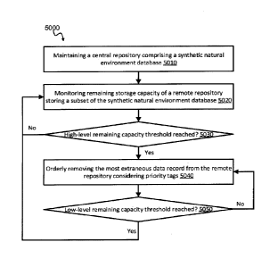
data storage
system may comprise one or more logical or physical as well as local or remote
hard disk
drive (HDD) (or an array thereof). The distributed data storage system may
further comprise a
local or remote database made accessible to the remote data management system
1100 and/or
the simulation stations 1200 by a standardized or proprietary interface or via
the network
1840/1940. The configuration variants of distributed data storage system
usable in the context
of the present invention will be readily apparent to persons skilled in the
art.
[0078]
Users of the interactive computer simulation system 1000 (e.g., users of the
simulation stations 1200) interact in the interactive computer simulation to
control a simulated
system in a computer generated environment of the interactive computer
simulation system
1000 (e.g., instructors or experts, trainees such as a pilot and co-pilot, a
driver, an operator, a
17
CA 03019434 2018-09-28
WO 2017/165947
PCT/CA2016/000097
surgeon, etc.). Examples of simulated system include an aircraft, a ground
vehicle, a marine
vessel, a spacecraft or space station, a control room, a patient, etc.
[0079]
The remote data management system 1100 may comprises a graphical user
interface module 1150 for performing various management tasks on the remote
data
management system 1100. However, as the remote data management system 1100 is
mainly
accessible remotely, the management tasks are also typically handled remotely.
[0080]
The simulation stations 1200.1...1200.n each comprise a tangible instrument
module 1260.1...1260.n (referred to together as the tangible instrument
modules 1260). The
tangible instrument modules 1260 each provide one or more tangible instrument
to the user of
the simulation stations for controlling the simulated system in the
interactive computer
simulation(s). Different tangible instruments are provided depending on the
system being
simulated. In the example of the aircraft, typical tangible instruments
include various switches,
levers, pedals and the like accessible to the user for controlling the
aircraft in the computer
generated environment of the interactive computer simulation(s). Depending on
the type of
interactive simulation (e.g., level of immersivity), the tangible instruments
may be more or
less realistic compared to an actual aircraft. While the present invention is
applicable to
immersive flat simulators certified for commercial training, skilled persons
will readily
recognize and be able to apply its teachings to other types of computer
simulations.
[0081]
Figure 2 provides a different logical view of the interactive computer
simulation
system 1000. The central repository 1500 of the distributed data storage
system is depicted as
being located at a storage facility 1800. The remote repository 1600 and the
simulation
stations 1200 are depicted as being co-located in a simulation facility 1900.
The network 1840
is depicted as a Wide Access Network (WAN), which typically connect remote
sites. The
network 1940 is depicted as a Local Access Network (LAN), which typically
connect systems
at a single site. In comparison to the example of Figure 1, the example of
Figure 2 shows the
proximate repositories 1700 as being integrated in their respective simulation
stations 1200. In
the example of Figure 2, the simulation station 1200.1 also comprises an
internal network
(LAN 1240) interconnecting different simulation data consumers 1280, 1282,
1284 thereof
towards the proximate repository 1700.1. The simulation data consumers 1280,
1282 and 1284
are relevant in some of the different embodiments to be further described with
particular
reference to figures 3A to 5B.
18
CA 03019434 2018-09-28
WO 2017/165947
PCT/CA2016/000097
[0082] Skilled persons will readily recognize that an actual interactive
computer
simulation system 1000 likely comprises many simulation stations 1200
distributed over
multiple simulation facilities (only 1900 shown). In the depicted example, the
central
repository 1500 contains all the synthetic natural environment database for
the interactive
computer simulation system 1000. The remote repository 1600 contains a subset
of data stored
at the central repository 1500 and each of the proximate repositories 1700
store a proximate
subset of the data stored at the remote repository 1600. The synthetic natural
environment
database could be distributed over different repositories (not shown) in a
manner transparent to
the remote repository 1600 (i.e., single network address for the central
repository 1500,
distributed or not). Likewise, the subset stored at the remote repository 1600
could be
distributed over different repositories (not shown) in a manner transparent to
the proximate
repositories 1700 or the simulation stations 1200 (i.e., single network
address for the remote
repository 1600, distributed or not). Similarly, when proximate repositories
1700 are provided,
the proximate subsets stored at the proximate repositories 1700 may yet also
be distributed
over different repositories (not shown) in a manner transparent to the
simulation stations 1200
(i.e., single network address for each of the proximate repositories 1700,
distributed or not).
The management functionalities of the remote data management system 1100
and/or central
repository 1500 may also be distributed over different network nodes or
provided by a
distributed virtual computer system or cloud system.
[0083] As such, the central repository 1500 comprises the synthetic natural
environment
database that comprises data for representing a geographically-mapped computer
generated
environment of the interactive computer simulation, comprising at least
geographically-
located terrain skin representation. During the interactive computer
simulation, the simulated
vehicle moves within the computer generated environment considering, among
other things,
commands received from user through the tangible instrument module 1260.1. In
order to
correctly convey the status of the simulated system at the present location,
the simulation
station 1200.1 requires the relevant geographically-located data from the
synthetic natural
environment database. As the complete synthetic natural environment database
is too large to
be stored and managed locally at the simulation station 1200.1, the simulation
station 1200.1
loads relevant data when needed. For instance, the simulation station 1200.1
would typically
require data (imagery, elevation, vector data, 3D polygon meshes, etc.) to
feed many different
subsystems thereof (display system, simulated instrumentation, simulated
collision avoidance
system, simulated radar, simulated sonar, audible warnings system, line-of-
sight determination
system, etc.). Different algorithms have been developed for determining what
data the
19
CA 03019434 2018-09-28
WO 2017/165947
PCT/CA2016/000097
simulation station 1200.1 should request data under different circumstances.
However, as the
synthetic natural environment database is stored remotely from the simulation
station 1200.1,
requesting the data incurs a first network delay for the request and a second
network delay for
the data. In addition, the network 1840 is typically a WAN that has more
limited and/or more
costly bandwidth. It would be beneficial to limit the number of exchanges
and/or limit the
amount of data exchanged thereover. It is therefore beneficial to increase the
likelihood of
getting the right data closer to the simulation station 1200.1, i.e., in the
remote repository 1600
(and/or the proximate repository 1700.1), e.g., to avoid a request over the
network 1840 and/or
1940 and/or to select when the data is sent over the network 1840 and/or 1940.
[0084] In accordance with a first set of embodiments particularly depicted
with reference
to Figure 1, Figure 2, Figure 3A and Figure 3B, the remote data management
system 1100 is
able to populate the remote repository 1600 with data that is expected to be
accessed by the
simulation stations 1200 (i.e., proactively pull data thereto). In order to do
so, the remote data
management system 1100 computes a plurality of expected geographical positions
for a
simulation station 1200.1 and anticipatorily updates the subset of the
synthetic natural
environment database stored in the remote repository 1600 with a supplemental
subset of the
synthetic natural environment database corresponding to one or more of the
computed
expected geographical positions.
[0085] In
accordance with a second set of embodiments particularly depicted with
reference to Figure 1, Figure 2, Figure 4A and Figure 4B, the remote data
management system
1100 is able to populate the remote repository 1600 with data limited to a
subset of data types
required by simulation data consumers 1280, 1282, 1284 of the simulation
stations 1200 (i.e.,
proactively filters data types therein). In order to do so, the remote data
management system
1100 parses one or more data requests from a simulation station 1200.1 for one
or more
geographical locations and determines a set of data types considering one or
more requesting
data consumers 1280, 1282, 1284 . The remote data management system 1100 then
updates
the subset of the synthetic natural environment database in the remote
repository 1600 for the
one or more geographical locations with data of only the set of data types.
[0086] In
accordance with a third set of embodiments particularly depicted with
reference
to Figure 1, Figure 2, Figure 5A and Figure 5B, the remote data management
system 1100 is
able to manage remaining storage capacity of the remote repository 1600 by
orderly removing
extraneous data records therefrom (i.e., proactively cleans the remote
repository 1600). In
order to do so, the remote data management system 1100 monitors remaining
storage capacity
CA 03019434 2018-09-28
WO 2017/165947
PCT/CA2016/000097
of the remote repository 1600. Upon reaching a high-level threshold value for
the remaining
storage capacity, the remote data management system 1100 removes a data record
from the
subset of data records stored in the remote repository 1600 until reaching a
low-level threshold
value for the remaining storage capacity. The most extraneous data record to
be removed is
identified considering one or more of a plurality of priority tags of the data
records.
[0087] Reference is now made concurrently to Figure 1, Figure 2, Figure
3A and Figure
3B describing the first set of embodiments. A method 3000 is disclosed for
supporting the
interactive computer simulation system 1000 that executes an interactive
computer simulation
on the simulation station 1200.1. The simulation station 1200.1 allows one or
more users to
interact in the interactive computer simulation for controlling a simulated
vehicle in a
computer generated environment. The method 3000 comprises maintaining 3010,
the central
repository 1500 of the interactive computer simulation system 1000,.
[0088] The method 3000 then comprises computing 3020 a plurality of
expected
geographical positions for the simulation station 1200.1 at a remote data
management system
1100. Thereafter, from the remote data management system 1100, the method 3000
follows
with anticipatorily updating 3050, via the network 1840/1940, a subset of the
synthetic natural
environment database stored in the remote repository 1600 accessible to the
simulation station
1200.1 with a supplemental subset of the synthetic natural environment
database
corresponding to one or more of the computed expected geographical positions.
[0089] In some embodiments of the first set of embodiments, the method 3000
may
further comprise monitoring 3040 remaining storage capacity of the remote
repository 1600.
In such an example, the supplemental subset may contain only data for
geographical positions
missing therefrom (i.e., circular motion of the simulated vehicle). The
anticipatory update
3050 may also be performed until reaching 3040 a high-level remaining capacity
threshold in
the remote repository 1600.
[0090] In some embodiments of the method 3000, the synthetic natural
environment
database may further comprise navigation content related to more than one
vehicles in the
computer generated environment. Computing 3020 the plurality of expected
geographical
positions may then further comprise considering the navigation content from
the perspective
of the simulation station 1200.1.
21
CA 03019434 2018-09-28
WO 2017/165947
PCT/CA2016/000097
[0091] In
some embodiments of the first set of embodiments, the remote repository 1600
is accessible to multiple simulation stations 1200.1...1200.n. Computing 3020
the plurality of
expected geographical positions is therefore performed for the simulation
stations 1200.
[0092] A
method 3100 is disclosed for supporting the interactive computer simulation
system 1000 that executes an interactive computer simulation on the simulation
stations 1200.
The simulation stations 1200 each allow one or more users to interact in the
interactive
computer simulation for controlling one or more simulated vehicles in a single
computer
generated environment. The method 3100 comprises maintaining 3110 the central
repository
1500 of the interactive computer simulation system 1000.
[0093] The method 3100 then comprises computing 3120 a plurality of
expected
geographical positions for the simulation stations 1200 at the remote data
management system
1100. Thereafter, from the remote data management system 1100, the method 3100
follows
with anticipatorily updating 3130, via the network 1840/1940, a subset of the
synthetic natural
environment database stored in the remote repository 1600 accessible to the
simulation
stations 1200 with a supplemental subset of the synthetic natural environment
database
corresponding to one or more of the computed expected geographical positions.
In this
example, computing 3120 the plurality of expected geographical positions is
therefore
performed for the simulation stations 1200.
[0094] In
the exemplary method 3100, the proximate repository 1700.1 is accessible to
the simulation station 1200.1, between the remote repository 1600 and the
simulation station
1200.1. The proximate repository 1700.1 stores a proximate subset of the
synthetic natural
environment database smaller than the subset stored in the remote repository
1600. As
mentioned with reference to other embodiments, the proximate repository 1700.1
may be
dedicated to the simulation station 1200.1. The disclosed method 3100 further
comprises, from
the remote repository 1600, computing 3142 a plurality of proximate expected
geographical
positions for the simulation station 1200.1 and anticipatorily updating 3152
the proximate
subset with a supplemental proximate subset of the synthetic natural
environment database
corresponding to one or more of the computed proximate expected geographical
positions.
While it is not mandatory, in typical embodiments, each of the simulation
stations 1200 is
associated with or provided with one of the proximate repositories 1700. The
remote
repository 1600 or the proximate repository 1700.1...1700.n, itself, would
then compute 3144
expected positions and update 3154 the relevant one(s) of the proximate
repositories 1700.
22
CA 03019434 2018-09-28
WO 2017/165947
PCT/CA2016/000097
[0095] In
the context of the exemplary method 3100, each of the simulation stations 1200
may execute a local interactive computer simulation application that strictly
accesses their
respective proximate repositories 1700 for obtaining geographically-located
data (e.g., for
displaying images) in relation to the computer generated environment of the
interactive
computer simulation (or a single point of contact therefor). Likewise, the
proximate
repositories 1700 may strictly access the remote repository 1600 (or a single
point of contact
therefor) and the remote repository 1600 may strictly access the central
repository 1500(or a
single point of contact therefor).
[0096] In
some embodiments of the first set of embodiments, the method 3100 may
further comprise monitoring (not shown) remaining storage capacity of the
remote repository
1600 and/or in the proximate repositories 1700. In such an example, the
supplemental subset
and/or the supplemental proximate subset may contain only data for
geographical positions
missing therefrom (i.e., circular motion of the simulated vehicle). The
anticipatory update
3130, 3152 and/or 3154 may then be performed until reaching a high-level
remaining capacity
threshold thereof
[0097]
Reference is now made concurrently to Figure 1, Figure 2, Figure 4A and Figure
4B describing the second set of embodiments. A method 4000 is disclosed for
supporting the
interactive computer simulation system 1000 that executes an interactive
computer simulation
on the simulation station 1200.1. The simulation station 1200.1 allows one or
more users to
interact in the interactive computer simulation for controlling a simulated
vehicle in the
computer generated environment. The method 4000 comprises maintaining 4010 the
central
repository 1500 of the interactive computer simulation system 1000. The
synthetic natural
environment database comprises data of a plurality of data types for
representing a plurality of
geographically-located elements (e.g., at least terrain skin representation,
but also typically 3D
polygon meshes, vector data and metadata) of the computer generated
environment of the
interactive computer simulation. The method 4100 comprises receiving 4020,
over the
network 1840/1940, a data request issued from the simulation station 1200.1
for one or more
geographical locations. In the second sets of embodiments, the simulation
station 1200.1
comprises the plurality of data consumers 1280, 1282, 1284 each requiring data
from one or
more of the plurality of data types. In typical embodiments, each of the data
consumers 1280,
1282 and 1284 perform their own data requests. In some other embodiments, the
data request
aggregates the data types from the requesting data consumers 1280, 1282, 1284
for the
geographical location(s) and a single data request is therefor sent.
23
CA 03019434 2018-09-28
WO 2017/165947
PCT/CA2016/000097
[0098]
The method 4000 comprises determining 4030 a set of data types considering one
or more requesting data consumers from the plurality of data consumers 1280,
1282, 1284 .
This may be performed by analyzing the data request(s) and determine a type of
data
consumer from an identifier therein. The data consumers 1280, 1282 and 1284
may also
register their required data types in the first data request or in advance of
the first data request.
The registration could be based on an identifier or an address of data
consumers 1280, 1282
and 1284.
[0099]
The method 4000 then comprises updating 4040, over the network 1840/1940, a
subset of the synthetic natural environment database stored in the remote
repository 1600 for
the one or more geographical locations with data of only the set of data
types.
[00100]
For instance, the plurality of data types may comprise rendering-faces data,
surface-texture data and reflectivity data. Examples of the data consumers
1280, 1282 and
1284 may include a radar system requiring rendering faces data and
reflectivity data and a
visual display system requiring rendering faces data and surface texture data.
Other examples
of the data consumers 1280, 1282 and 1284 that may require different data
types include sonar
(acoustic) sub-system, collision avoidance sub-system, infrared sensors sub-
system, night
vision goggles sub-system, electro-optical sub-system, computer generated
forces sub-system
(e.g., other elements that act within the simulated system), mission functions
sub-system (e.g.,
own-ship environment data), navigation sub-system, etc.
[00101] Determining 4030 the set of data types may be performed by a
logical union
operation of required data types from the one or more requesting data
consumers 1280, 1282,
1284 (e.g. from different requests for the same location(s) aggregated in a
single data push or
within the single data request). When the method 3000 and/or 3100 is used
together with the
method 4000, it is also helpful to consider data for expected locations for
all of the relevant
data types. For instance, the method 4000 may further comprise computing (not
shown) a
plurality of expected geographical positions for the simulation station 1200.1
and monitoring
(not shown) remaining storage capacity of the remote repository 1600. Updating
4040 the
subset may therefore be performed for one or more of the expected geographical
positions
until reaching a high-level remaining capacity threshold.
[00102] The synthetic natural environment database may further comprise
navigation
content related to more than one vehicles in the computer generated
environment wherein
24
CA 03019434 2018-09-28
WO 2017/165947
PCT/CA2016/000097
determining 4030 the set of data types may then be performed considering the
navigation
content from the perspective of the interactive computer simulation stations
1200.
[00103]
Updating 4040 the subset at the remote repository 1600 may also be performed
considering priority tags associated therewith.
[00104] A method 4100 is disclosed for supporting the interactive computer
simulation
system 1000 that executes an interactive computer simulation on the simulation
stations. Each
of the simulation stations allows one or more users to interact in the
interactive computer
simulation for controlling one or more simulated vehicle in the computer
generated
environment. The method 4100 comprises maintaining 4110 the central repository
1500 of the
interactive computer simulation system 1000. The synthetic natural environment
database
comprises data of a plurality of data types for representing a plurality of
geographically-
located data, as exemplified previously, of the computer generated environment
of the
interactive computer simulation. The method 4100 comprises receiving 4122,
4124, over the
network 1840/1940, data requests issued from more than one of the simulation
stations 1200
for one or more geographical locations. In the second sets of embodiments, the
simulation
stations 1200 each comprise the plurality of data consumers 1280, 1282, 1284
each requiring
data from one or more of the plurality of data types. In typical embodiments,
each of the data
consumers 1280, 1282 and 1284 perform their own data requests. In some other
embodiments,
the data request aggregates the data types from the requesting data consumers
for the
geographical location(s) and a single data request is therefor sent.
[00105]
The method 4100 comprises determining 4130 a set of data types considering one
or more requesting data consumers 1280, 1282, 1284 from the plurality of data
consumers.
This may be performed by analyzing the received data requests 4122, 4124
together or, more
typically, by performing the determination 4130 for each of the received data
requests 4122,
4124. The determination 4130 may be based on a type of data consumer from an
identifier in
the data request 4122, 4124. The data consumers 1280, 1282 and 1284 may also
register their
required data types in the first data request or in advance of the first data
request. The
registration could be based on an identifier or an address of data consumers
1280, 1282 and
1284.
[00106] The method 4100 then comprises updating 4140, over the network
1840/1940, a
subset of the synthetic natural environment database stored in the remote
repository 1600 for
the one or more geographical locations with data of only the set of data
types. For instance, the
CA 03019434 2018-09-28
WO 2017/165947
PCT/CA2016/000097
plurality of data types may comprise rendering-faces data, surface-texture
data and reflectivity
data. Examples of the data consumers 1280, 1282 and 1284 may include a radar
system
requiring rendering faces data and reflectivity data and a visual display
system requiring
rendering faces data and surface texture data. Other examples were also
previously provided.
[00107] Determining 4130 the set of data types may be performed by a
logical union
operation of required data types from the one or more requesting data
consumers (e.g. from
different requests for the same location(s) aggregated in a single data push
or within the single
data request). When the method 3000 and/or 3100 is used together with the
method 4100, it is
also helpful to consider data for expected locations for all of the relevant
data types. For
instance, the method 4100 may further comprise computing (not shown) a
plurality of
expected geographical positions for the simulation station 1200.1 and
monitoring (not shown)
remaining storage capacity of the remote repository 1600. Updating 4140 the
subset may
therefore be performed for one or more of the expected geographical positions
until reaching a
high-level remaining capacity threshold.
[00108] In the exemplary method 4100, the proximate repository 1700.1 is
accessible to
the simulation station 1200.1, between the remote repository 1600 and the
simulation station
1200.1. The proximate repository 1700.1 stores a proximate subset of the
synthetic natural
environment database smaller than the subset stored in the remote repository
1600. As
mentioned with reference to other embodiments, the proximate repository 1700.1
may be
dedicated to the simulation station 1200.1. The disclosed method 4100 further
comprises,
updating 4152 the proximate subset with a supplemental proximate subset of the
synthetic
natural environment database with data of only relevant data types. While it
is not mandatory,
in typical embodiments, each of the simulation stations 1200 is associated
with or provided
with one of the proximate repositories 1700. The remote repository 1600 or the
proximate
repository itself would then determine the set of data types 4140 accordingly
and update 4154
the relevant one(s) of the proximate repositories 1700.
[00109] In
the context of the exemplary method 4100, each of the simulation stations 1200
may execute a local interactive computer simulation application that strictly
accesses their
respective proximate repositories 1700 for accessing relevant geographically-
located data
(e.g., for displaying images) in relation to the computer generated
environment of the
interactive computer simulation (or a single point of contact therefor).
Likewise, the proximate
repositories 1700 may strictly access the remote repository 1600 (or a single
point of contact
26
CA 03019434 2018-09-28
WO 2017/165947
PCT/CA2016/000097
therefor) and the remote repository 1600 may strictly access the central
repository 1500 (or a
=
single point of contact therefor).
1001101 In some embodiments of the second set of embodiments, the method 4100
may
further comprise monitoring (not shown) remaining storage capacity of the
remote repository
1600 and/or of the proximate repositories 1700. In such an example, the
supplemental subset
and/or the supplemental proximate subset may contain only data for data types
missing
therefrom (e.g., reflectivity data already present, but texture data missing
as the radar system
reaches farther compared to the visual display system). The update 4140, 4152
and/or 4154
may then be performed until reaching a high-level remaining capacity threshold
thereof.
[00111] Reference is now made concurrently to Figure 1, Figure 2, Figure 5A
and Figure
5B describing the third set of embodiments. A method 5000 is disclosed for
supporting the
interactive computer simulation system 1000 that executes an interactive
computer simulation
on the simulation station 1200.1. The simulation station 1200.1 allows one or
more users to
interact in the interactive computer simulation for controlling a simulated
vehicle in a
computer generated environment. The method 5000 comprises maintaining 5010 the
central
repository of the interactive computer simulation system 1000. In this third
set of
embodiments, the synthetic natural environment database comprises a plurality
of data records
for representing the plurality of geographically-located data (e.g. as better
exemplified earlier,
terrain skin, polygon meshes, etc.) of the computer generated environment. The
remote
repository 1600 accessible through the network 1840/1940 stores a subset of
data records from
the synthetic natural environment database and one of a plurality of priority
tags is associated
with each one of the subset of data records.
[00112]
The method 5000 comprises monitoring 5020 remaining storage capacity of the
remote repository 1600 and, upon reaching a high-level threshold value 5030
for the
remaining storage capacity, removing 5040 the most extraneous data record from
the remote
repository 1600. The most extraneous data record is identified considering one
or more of the
plurality of priority tags, from the subset of data records stored in the
remote repository 1600.
The removal 5040 is performed until reaching 5050 a low-level threshold value
for the
remaining storage capacity.
[00113] In some embodiments, identifying the most extraneous data record
for removal
5040 may comprise sorting the subset of data records in the remote repository
1600 to obtain a
priority-ordered target list such that a top data record therefrom represents
the most extraneous
27
CA 03019434 2018-09-28
WO 2017/165947
PCT/CA2016/000097
data record for removal 5040. Removing 5040 the most extraneous data record is
therefore
performed by removing 5040 the top data record from the target list until
reaching 5050 a low-
level threshold value for the remaining storage capacity.
[00114] In
some embodiments, each one of the plurality of priority tags comprises a time-
based indication for obtaining a corresponding relative record age and a
record-insertion-
method indication. As exemplified in Figure 5B showing a specific example of
the removal
5040, the target list may first be sorted 5042 by considering the record-
insertion-method
indication before being further sorted 5044 by considering the time-based
indication. The
removal 5040 is therefore performed by removing 5046 the top data record from
the target list
until reaching 5050 a low-level threshold value for the remaining storage
capacity.
[00115]
For instance, the record-insertion-method indication may be one of "explicitly
requested from simulation" (e.g., requested by one or more of the simulation
stations 1200)
and "predicted by repository" (e.g., predicted using the method 3000 and/or
3100). The target
list may thus be ordered for all the "predicted" records at the top followed
by all the
"requested" records by age with the oldest towards the top. In this example,
the "predicted"
records are all removed before the "requested" records. The "predicted by
repository"
indication may further be expanded into "geographical prediction", "sub-data-
type" and "best-
guess". Where the geographical prediction is considered of higher priority
than sub-data-type,
which is itself of higher priority than best-guess. The priority tags may
further comprise a
"number of requestors" indication considered before the time-based indication
for ordering the
target list.
[00116] The method 5000 may also be performed when one or more of the
proximate
repositories 1700 are provided. The method 5000 may thus be performed
hierarchically from
the remote repository 1600 towards one or more of the proximate repositories
1700.
[00117] A method is generally conceived to be a self-consistent sequence of
steps leading
to a desired result. These steps require physical manipulations of physical
quantities. Usually,
though not necessarily, these quantities take the form of electrical or
magnetic/
electromagnetic signals capable of being stored, transferred, combined,
compared, and
otherwise manipulated. It is convenient at times, principally for reasons of
common usage, to
refer to these signals as bits, values, parameters, items, elements, objects,
symbols, characters,
terms, numbers, or the like. It should be noted, however, that all of these
terms and similar
terms are to be associated with the appropriate physical quantities and are
merely convenient
28
CA 03019434 2018-09-28
WO 2017/165947
PCT/CA2016/000097
labels applied to these quantities. The description of the present invention
has been presented
=
for purposes of illustration but is not intended to be exhaustive or limited
to the disclosed
embodiments. Many modifications and variations will be apparent to those of
ordinary skill in
the art. The embodiments were chosen to explain the principles of the
invention and its
practical applications and to enable others of ordinary skill in the art to
understand the
invention in order to implement various embodiments with various modifications
as might be
suited to other contemplated uses.
29