Note: Descriptions are shown in the official language in which they were submitted.
CA 03020069 2018-10-04
WO 2017/176112 1
PCT/NL2017/050206
Spatial data analysis
BACKGROUND OF THE INVENTION
Field of the invention
The present invention pertains to a spatial data analysis system.
The present invention further pertains to an arrangement comprising a 3D
scanner for generating spatial data and such a system.
The present invention still further pertains to a spatial data analysis
method.
Related Art
Point cloud data is commonplace in the surveying and mapping industries, along
with any field which requires computer modeling of natural or manmade objects.
Point cloud data comprises a set of cloud points (pi(xi,yi,zi)) each being
characterized at least by their coordinates in a three-dimensional coordinate
system (x,y,z). Optionally, the points may be further characterized by other
features, e.g. an intensity or an RGB value. Examples of fields using point
clouds
for modeling include healthcare, architecture, navigation, defense, insurance
underwriting, regulatory, and many more. As remote sensing technology has
improved over recent decades, the size and density of point cloud data has
increased rapidly. It is not uncommon to encounter scenarios with billions of
points in one small area of interest.
Maturana et al. discloses an application of convolutional neural networks for
classifying objects using point cloud data in their article: "VoxNet: A 3D
Convolutional Neural Network for Real-Time Object Recognition", Intelligent
Robots and Systems (IROS), 2015 IEEE/RSJ International Conference on. IEEE,
2015. The known system comprises a first component: a volumetric grid
representing an estimate of spatial occupancy, and a second component in the
form of a 3D convolutional neural network (CNN) that predicts a class label
directly from the 3D occupancy grid.
CA 03020069 2018-10-04
WO 2017/176112 2
PCT/NL2017/050206
It is further noted that Maturana, Daniel et al. discloses an application of
3D
CNN in "3D Convolutional Neural Networks for landing zone detection from
LiDAR", 2015 IEEE International Conference on Robotics and Automation
(ICRA), 26 mei 2015, bladzijden 3471-3478, XP055325310, DOI:
10.1109/ICRA.2015.7139679, ISBN: 978-1-4799-6923-4. This publication
pertains to a system for detection of small and potentially obscured obstacles
in
vegetated terrain. Maturana et al. point out that the key novelty of this
system is
the coupling of a volumetric occupancy map with a 3D Convolutional Neural
Network (CNN).
It is a disadvantage of these known systems that a relatively large amount of
memory is required to store the 3D occupancy grid.
SUMMARY OF THE INVENTION
It is an object to provide an improved spatial data analysis system and
spatial
data analysis method for obviating necessity of a 3D occupancy grid. It is a
further object to provide an improved arrangement comprising a 3D scanner and
the improved system.
The improved system comprises a statistical analysis module having an input to
receive data elements having a data element position with coordinates in a two-
dimensional coordinate system and a data element value for said data element
position derived from the coordinates of respective spatial data points. The
improved system is particularly suitable for processing point cloud data as
the
spatial data, e.g. rendered by a point cloud source (e.g. a Lidar arrangement)
integrated in the system or may be retrieved from another source, e.g. from a
memory or from a computer graphics system. The data elements to be processed
by the statistical analysis module may be derived from the cloud points for
example by selecting two of the coordinates (e.g. the x and y coordinates) of
the
cloud points as the two coordinates that determine the position of the cloud
points while using the value of the third coordinate (e.g. the z-coordinate)
as the
CA 03020069 2018-10-04
WO 2017/176112 3
PCT/NL2017/050206
value for the position. Alternatively the data points may be derived from
spatially transformed cloud points, e.g. by first subjecting the cloud points
to a
rotation or a conversion from polar to Cartesian coordinates. A data element
is
said to originate from an object if the corresponding data point in the
spatial data
.. originates from that object. Where the spatial data is point cloud data
this is the
case if the cloud point corresponding to the data element originates from the
object. The statistical analysis module calculates a discrete spatial
distribution of
at least one statistical measure derived from the data elements. The spatial
distribution defines a statistical measure value of the at least one
statistical
measure for respective raster elements in a raster, preferably a two-
dimensional
raster. The statistical measure at least comprises an indicator indicative of
an
elevation distribution of data elements contained by the raster element.
Therein
each raster element is associated with a respective spatial window that
comprises
a subset of the data elements derived from the spatial data, e.g. the point
cloud
data. It is noted that in some cases the subset may be empty, for example near
the edges of the observed range. Also this may be the case due to statistical
fluctuations in the spatial distribution of the data points. Preferably the
density
of data points is in the order of 5 to 100 points per raster element, for
example
about 5 to 20 points per raster element. The statistical analysis module
.. calculates the statistical measure value for a raster element from the
respective
values of the data elements comprised in the spatial window associated with
the
raster element. Therewith rasterized statistical data is obtained. The
improved
system further comprises a convolutional neural network that is
communicatively coupled to the statistical analysis module to receive the
rasterized statistical data and configured to provide a classification of
objects
based on the rasterized statistical data. Hence contrary to the known system
the
statistical analysis module is provided that converts the three-dimensional
point
cloud data to two-dimensionally rasterized statistical data and provides this
as
the input data to the convolutional neural network. It has been observed that
the
.. inclusion of the indicator indicative of an elevation distribution of data
elements
contained by the raster element as a statistical measure, enables a good
performance of the system despite the reduction to two dimensions.
CA 03020069 2018-10-04
WO 2017/176112 4
PCT/NL2017/050206
As indicated above, the improved system is particularly useful for analysis of
point cloud data as the statistical analysis module provides rasterized
statistical
data as its output to the convolutional neural network independent of the
spatial
distribution of the spatial data. Nevertheless, the improved system is useful
also
.. for processing rasterized spatial data. Such rasterized spatial data could
be
considered as a special case of point cloud data, wherein the cloud points are
arranged according to a raster instead of being arbitrarily scattered. The
statistical analysis module can analogously use this spatial data as its input
provided that the input raster with the spatial data has a sufficiently high
resolution as compared to the spatial window used by the statistical analysis
module, e.g. having a density of at least 5 spatial data points within the
spatial
window.
The improved arrangement comprises a 3D scanner for generating spatial data
.. and an improved system as specified above to classify objects using said
spatial
data as specified by any of the previous claims and the improved system. In
the
context of this application a 3D scanner is understood to be a device that
renders
a three dimensional representation of a scanned range. The 3D scanner may be
implemented in various ways, depending on the circumstances. For example the
.. 3D scanner may have a fixed position or may be integrated with a movable
carrier, e.g. a car, a plane or a vessel. Various technologies are available
for this
purpose, such as stereoscopic imaging, time of flight measuring. Imaging
and/or
measurement may be based on sensed signals of various nature, such as
acoustic,
optic or radar signals.
The improved spatial analysis method comprises:
- receiving spatial data, which comprises a set of spatial data points
each
being characterized at least by their coordinates in a three-dimensional
coordinate system,
- calculating a discrete two-dimensional spatial distribution of at least
one
statistical measure from data elements having a data element position (p) in a
two-dimensional coordinate system and a data element value (q) for said data
CA 03020069 2018-10-04
WO 2017/176112 5
PCT/NL2017/050206
element position (p) derived from the coordinates of spatial data pointsõ said
spatial distribution defining a statistical measure value of said at least one
statistical measure for respective raster elements in a raster, each raster
element
being associated with a respective spatial window comprising a subset of said
set
of points, the statistical measure value for a raster element being calculated
from
the respective data element values of the data elements in the subset of data
elements comprised in the spatial window associated with the raster element,
the
discrete two-dimensional spatial distribution being rasterized statistical
data,
- providing the rasterized statistical data to a convolutional neural
network,
configured to provide object information about objects identified in the point
cloud data by the spatial analysis method.
It has been found that good classification results can be obtained on the
basis of
rasterized statistical data. Therewith the need of a 3D occupancy grid is
avoided.
Dependent on the application different types of object information may be
provided. In an embodiment the object information is a classification of
objects
based on the statistical data. In another embodiment the object information is
an
estimated position of an object.
In an embodiment the two-dimensional spatial distribution is defined in a
plane
defined by a first and a second coordinate axis in said three-dimensional
coordinate system, and wherein said quantity is an elevation defined in said
three-dimensional system. As indicated above, an additional spatial
transformation may be applied to spatially transform the spatial data, e.g. a
point cloud into another coordinate system. It is also noted that further
input
data may be used, for example the intensity of a reflected beam resulting in
the
cloud point of the point cloud. Also such a quantity may be provided by
another
input means, for example a camera.
In an embodiment the statistical analysis module comprises a pre-filter for
removing outliers from the data elements representing the spatial data, such
as
CA 03020069 2018-10-04
WO 2017/176112 6
PCT/NL2017/050206
point cloud data. The pre-filter may for example remove data having a value
for
said quantity in the lower above the 95th or below the 5th percentile. A
preprocessing module may further be used to combine point cloud data obtained
from different recordings.
Useful statistical measures that may be calculated by the statistical analysis
module are for example a point count density (N), a lowest elevation (LE), a
highest elevation (HE), a difference between the highest elevation and the
lowest
elevation (HL), a maximum vertical gap (VG), a minimum vertical gap (LD), an
average vertical gap (AD), an average elevation (AH), a standard deviation
(SD),
a surface normal vector (SN), a planar variance (PV), and a derived hard
surface
elevation (HS). The point count density indicates the number of data elements
in
each raster element. The lowest elevation is the lowest value observed for the
elevation of the data elements in the raster element. The highest elevation is
the
highest value observed for the elevation of the data elements in the raster
element. The maximum, the minimum and the average vertical gap respectively
are the maximum difference, the minimum difference and the average difference
in elevation between two consecutive data elements ordered in the z direction.
The average elevation is the average value of the elevations of the data
elements
in the raster element. The standard deviation in this context is the standard
deviation of the distribution of the elevation values. The surface normal
vector is
an indication of the normal vector of a surface interpolated through the data
elements contained in the raster element. The planar variance is an indication
of
the extent to which the data elements deviate from the surface interpolated
there
through. The derived hard surface elevation is an indication of the surface
hardness based on the intensity of the reflected beam used to generate the
point
cloud.
In an embodiment the statistical analysis module calculates as the statistical
measure for the raster element at least an indicator indicative of an
elevation
distribution of data elements contained by the raster element. It has been
found
that this type of statistical measure renders it possible to achieve results
that are
CA 03020069 2018-10-04
WO 2017/176112 7
PCT/NL2017/050206
comparable with results achievable with a 3D convolutional neural network,
while still obviating the need of a 3D data representation. A possible
explanation
is that in the claimed system the CNN operates on 2D distributed data,
contrary
to the cited prior art which operates on an occupancy grid in three
dimensions.
The addition of a statistic measure indicative for an elevation distribution
is
believed to enable the CNN operating on the two dimensional raster to learn to
recognize patterns of a three-dimensional nature.
Examples of indicators that are indicative of an elevation distribution of
data
.. elements are a difference between the highest elevation and the lowest
elevation,
a maximum vertical gap, a minimum vertical gap, an average vertical gap, a
standard deviation, and a planar variance. A very suitable one of these
indicators
is the difference between the highest elevation and the lowest elevation as it
can
be computed with a minimum of computational effort.
The indicator indicative of an elevation distribution of data elements may be
provided to the CNN for example in combination with a second indicator
selected
from a lowest elevation, a highest elevation, an average height, and a median
height value.
Still further indicators may be provided, for example by adding time as input
data to the statistical module. Using this information an indicator for e.g. a
velocity or an acceleration value may be determined.
.. The convolutional neural network of the system may include one or more
convolutional layers, one or more reduction layers and one or more fully
connected layers. Reduction layers are for example pooling layers or dropout
layers.
In an embodiment the convolutional neural network comprises ordered in the
sequence from input to output a first pair of convolutional layers, a first
pooling
CA 03020069 2018-10-04
WO 2017/176112 8
PCT/NL2017/050206
layer, a second pair of convolutional layers, a second pooling layer and a
pair of
fully connected layers.
An embodiment of the system further includes a post-processing module that is
.. communicatively coupled to the convolutional neural network to receive the
object information and to further process the object information. Therewith
the
post-processing module may extract further object information or to extract
relation information about relations between identified objects.
BRIEF DESCRIPTION OF THE DRAWINGS
These and other aspects are described in more detail with reference to the
drawing. Therein:
FIG. 1 illustrates an embodiment of the system according to the invention,
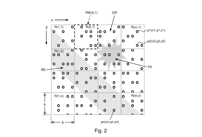
.. FIG. 2 illustrates various elements relevant for operation of the system,
FIG. 3 illustrates exemplary architectures of a part of the system of FIG. 1,
FIG. 4 illustrates another embodiment of the system according to the
invention,
FIG. 5 shows an example having overlaid therein the raw point cloud data and
objects identified therein,
FIG. 5A shows a portion in more detail.
DETAILED DESCRIPTION OF EMBODIMENTS
Like reference symbols in the various drawings indicate like elements unless
otherwise indicated.
FIG. 1 schematically illustrates a spatial data analysis system 20, 30 . The
system, suitable for analysis of spatial data, such as point cloud data
(pi(xi,yi,zi))
is part of an arrangement that further includes a 3D scanner for providing the
.. spatial data. In the embodiment shown, spatial data is provided as point
cloud
data that comprises a set of cloud points (pi(xi,yi,zi)). Each data point,
here a
cloud point, is characterized at least by its coordinates in a three-
dimensional
CA 03020069 2018-10-04
WO 2017/176112 9
PCT/NL2017/050206
coordinate system (x,y,z),In the embodiment shown, the cloud points are
received
as data elements z1(x1,37) having a data element position (p) with coordinates
(xl,y) in a two-dimensional coordinate system and a data element value (z) for
said data element position (p) derived from the coordinates of respective
cloud
points. Hence in this embodiment the coordinates of a position (p) of a data
element are determined by a first and a second one of the coordinates of the
corresponding cloud point and its value (q) is determined by a third one of
said
coordinates.
In an alternative embodiment the system may further comprise a spatial
transformation module to receive said point cloud data in the three
dimensional
coordinate system, and to transform the point cloud data to an alternative
three
dimensional coordinate system. In that case the coordinates of a position (p)
of a
data element may be determined by a first and a second one of the coordinates
of
the corresponding cloud point in the alternative three dimensional coordinate
system and its value (q) may be determined by a third one of the coordinates
in
the alternative three dimensional coordinate system. Alternatively or in
addition
other quantities may be used. In the embodiment shown the system further
receives input RGB(xi,yi) from a camera.
In another embodiment the spatial data may be provided as rasterized data
points rp(xi,yi,z), wherein the coordinates x1,371 are positions on a raster
and z, are
the values for the points on the raster. Similarly, this spatial data can be
provided as data elements zi(xi,yi) having a data element position (p) with
coordinates (x,y) in a two-dimensional coordinate system and a data element
value (z) for said data element position (p) derived from the coordinates of
respective cloud points.
FIG. 2 shows an example of cloud data obtained with a 3D scanner, here an
imaging sensor having depth measurement capacity. Therein the image sensor
generates spatial data as a point cloud comprising a set of n cloud points
pl(xl,y1,z1), p2(x2,y2,z2), pn(xn,yn,zn). The cloud points pi(xi,yi,zi) are
characterized by their coordinates (xi,yi,zi) in a three-dimensional
coordinate
system, and have a respective measured value for a quantity, here the depth zi
of
CA 03020069 2018-10-04
WO 2017/176112 10
PCT/NL2017/050206
the cloud points. In this case the coordinate system is a Cartesian coordinate
system defined by first and a second axis x,y as shown in the drawing and by a
third axis z orthogonal to the drawing. Instead an alternative three
dimensional
coordinate system may be used, such as a polar coordinate system. By way of
.. example the 3D scanner obtained an aerial survey from a scene comprising a
road RD traversing a meadow GR on which further a tree TR is arranged.
Numerous other applications are conceivable, such as visualization of a seabed
surface.
As shown in FIG. 1, the system comprises a statistical analysis module 20 that
has an input 21 to receive the spatial data, in this case the point cloud
data, as
data elements, each having an elevation z, for a position with coordinates
xl,y1. It
further has a computation facility 22 to calculate a discrete two-dimensional
spatial distribution (V(k,1)) of at least one statistical measure derived from
the
data elements derived from the point cloud data. The spatial distribution
defines
a statistical measure value of the at least one statistical measure for
respective
raster elements (R(k,1)) in a two-dimensional raster. Each raster element is
associated with a respective spatial window (RW(2,1)) that comprises a subset
of
of the data elements. The statistical analysis module calculates the
statistical
measure value for a raster element from the respective values of the data
elements contained in the spatial window associated with the raster element.
It is noted that the contribution of the data elements in the calculation of
the
statistical value may be weighted by their position inside the spatial window.
For
example more centrally arranged data elements may be weighted higher than
more peripherally arranged data elements. In the embodiment shown the spatial
windows may form a tiling, i.e. the stride in the directions x,y is equal to
the size
of the spatial windows. Alternatively, the stride may differ from the
dimension of
the window. For example in case a weighting of the contribution of the data
elements is applied the stride may be smaller than the window size, so that
the
.. tail of the weighting functions associated with mutually neighboring
windows
overlap.
CA 03020069 2018-10-04
WO 2017/176112 11
PCT/NL2017/050206
By way of example the spatial window RW(2,1) of raster element R(2,1) is
indicated by dashed lines. In the embodiment shown the raster elements have
mutually non-overlapping spatial ranges, but, as indicated above,
alternatively
embodiments may be contemplated wherein spatial ranges of mutually
neighboring ranges overlap to some extent. In the embodiment shown the spatial
window of a raster element is a rectangle defined by an upper left coordinate
xk,371
and a lower right coordinate Xk+1, 371+1, wherein:
xk = k* sx;xk i =(k +1)* sx , and
V1 =1* s y;y1+1 = (1+1)* s y
Therein sx,sy are the sizes of the raster elements in the x- and the y-
direction
respectively. The size sx,sy may be a function of the position x,y, for
example to
take into account the local density of the data elements. For example, in case
of a
non-homogeneous distribution of the data elements the size sx,sy may be higher
in areas having a low density of data elements than in areas having a high
density of data elements, so that the number of data elements in each raster
element is approximately equal.
In the embodiment shown, the sx,sy = s, and each raster element contains about
5
to 10 data elements. However, in other embodiments the number of data
.. elements may be lower or higher, depending on the required accuracy and on
the
available computational capacity.
The statistical analysis module 20 calculates a discrete two-dimensional
spatial
distribution of a statistical measure calculated for the data elements derived
from the spatial data, here point cloud data. The spatial distribution defines
a
statistical measure value V(k,l) of the statistical measure for each of the
raster
elements from the data element values of the data elements contained in its
associated spatial window. The statistical measure may be one of a plurality
of
statistical measures, and the statistical analysis module may calculate a
discrete
.. two-dimensional spatial distribution for each of the plurality of measures.
Accordingly the result provided by the statistical analysis module is
typically a
CA 03020069 2018-10-04
WO 2017/176112 12
PCT/NL2017/050206
two-dimensional raster of vectors. I.e. the statistical analysis module 20
calculates for each of the elements of the two-dimensional raster a vector
having
the values for the plurality of statistical measures as its components. It is
alternatively possible to add one or more of the statistical measures as a
dimension of the raster. For example the statistical analysis module 20 may
provide its results in a three-dimensional coordinate system, having in
addition
to the coordinates k,1 a third coordinate having a value equal to the value of
one
of the statistical measures, while providing the values of the remaining
statistical measures as the values of the vector components for the elements
defined by these three coordinates. Similarly the coordinate system may be
extended with other statistical measures.
A preprocessing module may be provided that preprocesses the data elements
derived from the raw spatial data (e.g.point cloud data), for example by
removing
outliers. For example the preprocessing module may remove data elements
having a depth value above the 95th or below the 5th percentile. A further
preprocessing module may be used to combine spatial data (e.g. point cloud
data)
obtained from different recordings.
Accordingly, in the embodiment shown, the statistical analysis module
calculates
the statistical measure value V(k,l) as:
V(k,/)= V (vq,1,vq,2,...,vq)
Therein
are the data element values of the data elements ii, i2, ikl,
contained in the spatial window RW(k,l) of the raster element R(k,1). It is
noted
that the number of data elements contained in the spatial window RW(k,l) of a
raster element R(k,l) may vary, and sometimes may be 0.
As indicated above, the statistical analysis module may apply a weighting
function to weight the contribution of the values for the measured quantity.
For
example, the weighting function may apply a higher weight to values associated
CA 03020069 2018-10-04
WO 2017/176112 13
PCT/NL2017/050206
with data elements centrally arranged in the spatial window than to values of
data elements that are more peripherally arranged.
The system further includes a neural network 30, here a convolutional neural
network that receives the statistical data V(k,l) representing the discrete
two-
dimensional spatial distribution. In response thereto it provides information
about objects based on the statistical data.
The statistical analysis module 20 may for example compute one or more of the
following statistical measures for each raster element R(k,l) with spatial
window
RW(k,1), low elevation, high elevation, elevation standard deviation, surface
normal vector, point count density and vertical gap. These statistical
measures
are defined as follows:
Point count density N
The point count density is the number N(k,l) of data elements contained in the
spatial window.
N (k 1) ¨ 1
iE RW (k ,l)
Low elevation LE
The low elevation is defined as the minimum value for the elevation of the
data
elements contained in the spatial window.
LEO ,1) = min (z.)
icRok,i)
Therein i c RW(k,/) denotes that i is a data element in the spatial window
RW(k,1), and z1 is the elevation of that data element.
High elevation HE
Similarly the high elevation measure is defined as follows:
HE(k,1) = max (zi)
iERw(k,i)
CA 03020069 2018-10-04
WO 2017/176112 14
PCT/NL2017/050206
High minus low HL
HL(k ,1) = max (zi )- min (zi
iERw(k,i) iERok,i)
Vertical gap VG
A measure related to HL is the (maximum) vertical gap VG. This is the largest
vertical separation between (valid) elevations in a raster element. Elevation
is
defined here as the value (z) of a data element. The wording valid is included
between brackets to clarify that the measure is only based on the remaining
.. elevations in case outliers are removed.
If for example a raster window contains data elements originating from a tree
branch, and other data elements originating from the ground; the data elements
originating from the tree branch will have similar elevations spread over a
small
range, and the data elements originating from the ground will have elevations
spread over an even smaller range. The largest vertical separation is likely
between the lowest point on the branch and the highest point on the ground.
This
separation is recorded as the vertical gap and can be computed as:
VW, /) = max (z,1(+1) Z,1())
Therein n(i) is the function that indicates the ith data element ordered by
its z-
value from small to large. I.e. n(1) indicates the data element with the
smallest z-
value and n(N) indicates the data element having the largest z-value.
Lowest Z difference LD
Likewise a measure LD, which may also be denoted as "minimum vertical gap"
may be defined as:
LD (1( ,1) = min (zi1(i+1) - zn(i))
Average Z Difference AD
CA 03020069 2018-10-04
WO 2017/176112 15
PCT/NL2017/050206
Further a measure AD, also denoted as "average vertical gap" may be calculated
as:
1 N
AD(k,1)= ¨11n(i+1)¨ Zn(i))
Average elevation All
The average elevation of the data elements contained in the spatial window RW
(k,l) is defined as:
1
AH (1( , 1) = ________________ I zi
1) iERW(k,l)
In an alternative embodiment the median value MD of the elevation may be
calculated for the subset of data elements.
Standard deviation SD
The standard deviation
Z-
1 1
\SD(k,/)= Z?' ieRw(k,t) =1/ / Z.2 ¨ AH(k, 1) N(k,1 N
k 1 Mk,1
Surface normal vector SN
The surface normal vector may be estimated as a surface normal vector of a
polynomial surface, that is interpolated through the data elements contained
in
the spatial window of the raster element R(k,1).
Accordingly as a first step a polynomial surface of degree p is fitted through
the
data elements contained in that spatial window.
Z(x, y; k , 1)¨ lat., jxi y j
CA 03020069 2018-10-04
WO 2017/176112 16
PCT/NL2017/050206
A least squares method may be applied for example. The degree p of the
polynomial should not be too high in order to avoid overfitting. A maximum
boundary of the degree p is defined by:
(p +1)(p +2) 2AT(k,l)
In an embodiment a plane is interpolated as the polynomial surface through the
data elements contained in the spatial window.
After the interpolating surface is determined, its surface normal vector is
determined at a characteristic position of the spatial window, typically the
center
of the spatial window.
The surface normal vector may be expressed in various ways, for example as a
pair of the angle between the surface normal vector with the z-axis and the
direction of the component of the surface normal vector transverse to the z-
axis.
In an embodiment the surface normal vector is expressed as the cosine of the
angle with the z-axis.
Planar variance PV
The planar variance is a measure that indicates to which extent the data
elements contained in the raster element fit into a plane interpolated through
the
data elements. When using a least square method to determine the best fitting
plane for a raster element R(k,1), the minimal value of the squared error is
the
planar variance PV(k,1). Related statistics may be defined using another
distance
measure, e.g. when applying an interpolation method that minimizes the
absolute value of the error, the minimized absolute value is the planar
variance.
Derived (hard) surface elevation HS
Derived surface elevation is an estimated elevation of the ground without
consideration for man-made objects (example: vehicles, towers, signs,
buildings,
or bridges). Derived hard surface elevation is an estimated elevation of any
building, bridge, or ground in the cell; without consideration for other man-
made
objects).
CA 03020069 2018-10-04
WO 2017/176112 17
PCT/NL2017/050206
Information from other data sources may be combined with the rasterized
statistical information. The information from these other sources may already
be
present in a rasterized format, for example as RGB (x,y) data or rasterized
intensity data obtained with a camera, for example a camera operating in the
visual spectrum or in the infrared spectrum. Additional channels can be
included
to provide this rasterized data in a manner compatible with the rasterized
statistical data. I.e. for each raster element input data for a measured RGB
or
intensity value may be provided in addition to one or more of the statistical
data.
Compatibility may be achieved by a geometrical transformation and/or spatial
interpolation of the additional data.
Data-elements may be associated with a time of acquisition of the spatial data
from which they are derived. Presumed that a sufficient number of data
elements
is available, the associated acquisition time may be used to estimate a
temporal
behavior of an object represented by the data cloud. The temporal behavior,
e.g. a
velocity of the object can be estimated by interpolating a 4-dimensional
hyperplane through data elements derived from the observed data points
(x1,371,z1,t1)
For a hyperplane defined by:
axx+ayy+azz¨att=q
the velocity vk in a direction k (x,y,z) of the object can be estimated as
at
vk =¨
a,
Also higher order temporal behavior may be estimated, for example by comparing
the estimated velocities at mutually subsequent points in time.
As further shown in FIG. 1, the system comprises a convolutional neural
network
30, that is communicatively coupled to the statistical analysis module 20 to
receive the rasterized statistical data V(k,l) prepared by the statistical
analysis
module 20. The convolutional neural network is configured to provide a
information about objects identified by the system, for example a
classification
CA 03020069 2018-10-04
WO 2017/176112 18
PCT/NL2017/050206
(C(k,1)) of objects, or an estimated position of an object (present in the
range
observed by an 3D scanner) based on the rasterized statistical data.
The convolutional neural network 30 comprises a plurality of layers, wherein
the
first layer receives the rasterized statistical data V(k,1), and wherein each
subsequent layer processes output data obtained from the previous layer. The
final layer provides the classification result C(k,1).
Exemplary implementations (Arch1,...Arch7) of the convolutional neural network
are shown in FIG. 3. The convolutional neural network typically contains one
or
more convolutional layers, one or more reduction layers and one or more fully
connected layers. In the path through the various layers, starting with the
inputs
of the first layer that retrieves the data elements from the statistical
analysis
module 20 to the output of the last layer, object information is retrieved
about
.. objects identified in the spatial data. Depending on the application, the
retrieved
information may for example indicate a class to which an object is assigned or
an
object position. The retrieved information may alternatively be provided as a
probability distribution across classes or positions. Also embodiments are
conceivable where the CNN 30 provides at its output information about various
aspects of an object or objects.
Convolutional layers
The convolutional layers, denoted as Cony k,n,m create feature maps by
convolving the input with k learned filters (kernels) of a particular shape
and of
size n,m pixels. The parameters of this type of layer are the number of
kernels k,
and their spatial dimensions n,m. For example a convolutional layer denoted as
Cony 32, 5, 5 uses 32 kernels having a window sized 5x5 pixels. When the input
is an NxM image, the result is an (N-n+1)x(M-m+1) vector image. Therein each
pixel is a vector of length k, wherein each element of the vector is a value
for a
particular feature associated with the respective kernel at the position of
the
pixel. Convolution can also be applied at a spatial stride. The output may be
passed through a nonlinearity unit.
CA 03020069 2018-10-04
WO 2017/176112 19
PCT/NL2017/050206
It is noted that the wording 'image' and 'pixel' are used here in a broad
sense.
The wording pixel in this context is an element associated with a position in
a
raster and having a vector of one or more features. The wording image in this
context is the set of pixels in this raster.
Reduction layers
A reduction layer provide for a data reduction in particular to avoid
overfitting.
One type of reduction layer is a pooling layer (MaxPool: n,m). A layer of this
type
provides for a data reduction by downsampling. In particular this type of
layer
downsamples the data retrieved from its input raster by selecting the maximum
value of the inputs on a window of nxm data elements. Typically the windows
used for the MaxPool layer provide for a tiling of the input image, so that
the
windows are displaced with stride n in the first direction and with stride m
in the
second direction. This implies that the number of pixels is reduced by a
factor n
in the first direction and a factor m in the second direction.
Accordingly, a reduction layer of type MaxPool: with m=2 and n=2 will
partition
the input raster into 2x2 windows and provide for a data reduction of 4:1.
However, alternative embodiments may be considered wherein the stride differs
from the dimensions of the window. Also other subsampling techniques may be
used, such as Fractional MaxPooling.
Another type of reduction layer is a dropout layer (DropOut: p)). The dropout
layer is configured during training by removing nodes of the layer with
probability p in each training stage. Only the reduced network is trained on
the
data in that stage. The removed nodes are then reinserted into the network
with
their original weights. Upon completion of the training each of the weights is
assigned a value equal to the average of the values determined for that weight
during the stages of the training. The average of the values is normalized by
division with 1-p.
CA 03020069 2018-10-04
WO 2017/176112 20
PCT/NL2017/050206
Fully connected layers
In a fully connected layer (FC: nn), the output of each neuron is a learned
linear
combination of all the outputs from the previous layer, passed through a
nonlinearity. In case the previous layer provides its outputs as a vector
having a
plurality of vector elements for each neuron, the output of each neuron in the
fully connected layer is based on the weighted combination of the values of
each
of the vector elements of each of the outputs of the previous layer.
Nevertheless
in the trained CNN 30, individual weights may have a value of zero. The fully
connected layer may provide its output a classification, i.e. an indicator
indicative
for a selection from a predetermined set of classes. The parameter nn
indicates
the number of neurons in the layer.
Activation Function
The nodes of a layer use an activation function to determine whether a
weighted
set of inputs matches a particular pattern. The activation function typically
provides for a non-linear mapping of a sum of the weighted set of inputs to a
value in the range of [0,1], for example using the sigmoid function. Also
other
activation functions may be used, for example, the non-saturating function
f(x) =
max(0,x) or the hyperbolic tangent function.
In the exemplary architecture Arch1 in FIG. 3, the CNN subsequently four
convolutional layers Cony: n, m, n, a reduction layer, a fully connected
layer, a
reduction layer and a fully connected layer. Both reductions layers are
provided
as a dropout layer indicated as DropOut p. The fully connected layers,
indicated
as FC: nn, assign one of nn classes to their outputs.
The second exemplary architecture Arch2 differs from the first example Archl,
in
that the first four convolutional layers are replaced by a first convolutional
layer,
a reduction layer and a second convolutional layer.
The third exemplary architecture Arch3 differs from the first example Archl,
in
that subsequently a pooling layer (MaxPool: 2,2) and a dropout layer (DropOut:
CA 03020069 2018-10-04
WO 2017/176112 21
PCT/NL2017/050206
0.25) are inserted. Additionally a further pooling layer (MaxPool: 2,2) is
inserted
between the fourth convolutional layer and the subsequent layers.
The fourth example Arch4 can be considered as a simplification of the example
Arch2, in that the two dropout layers are left out.
Architectures Arch5, Arch6 and Arch7 have the same arrangement, sequentially
comprising the a first pair of convolutional layers, a first pooling layer, a
second
pair of convolutional layers, a second pooling layer and a pair of fully
connected
layers. These architectures however differ in that these layers are provided
with
mutually different parameters.
General direction concerning training the CNN as provided for example in the
following documents.
Must Know Tips/Tricks in Deep Neural Networks by Xiu-Shen Wei, retrieved
from http://lamda.nju.edu.cn/weixs/project/CNNTricks/CNNTricks.html on 25
March 2016.
Therein Xiu-Shen Wei amongst others considers various strategies for
efficiently
training convolutional neural networks, such as data augmentation, pre-
processing on images, initializations of networks, selections of activation
functions, diverse regularizations, methods of ensemble multiple deep
networks.
As noted by Xiu-Shen Shan, an important issue is to keep the learning rate at
a
modest level. If it is found that to much 'neurons' not become active for the
entire
training set, the learning rate should be decreased. Optionally upon
completion of
the training, the most upper layers of the CNN, i.e. near its input, may be
fine
tuned while keeping fixed the settings for the deepest layers, i.e. near the
output.
Further information on training of CNN can be found in "Recent Advances in
Convolutional Neural Networks", by Jiuxiang Gu et al, retrieved from
http://arxiv.org/pdf/1512.07108.pdf on 25 March 2016.
Additional information concerning possible implementations of the various
layers
and their activation functions can be found for example in the Wikipeclia
article
on this subject (https://en.wikipedia.org/wiki/Convolutional neural network).
CA 03020069 2018-10-04
WO 2017/176112 22
PCT/NL2017/050206
Experimental results
Point cloud data was obtained by scanning a terrain with buildings and ditches
using point cloud data distributed in a three-dimensional space, defined by a
Cartesian coordinate system, having x,y coordinates defining the plane of the
observed area and a z-coordinate defining an elevation (also denoted as
height).
The point cloud data was obtained with a LIDAR sensor measuring in a
substantially downward oriented direction. According to standard practice,
using
gps and inertial navigation information and taking into account the relative
sensor position and orientation the sensed data was transformed to a common x,
y, z coordinate system. The transformed point cloud data elements so obtained
were then converted into rasterized statistics.
The rasterized statistics were calculated for a raster having raster elements
sized
1m x 1m based on an average number of about 10 data elements per raster
element. The following rasterized statistics, as defined above, were
calculated.
ILE(k,1); HE(k,1); HL(k,1); SD(k,1); SN(k,1)}.
One or more of these rasterized statistics were provided to a neural network
to
classify elements in the terrain or the absence thereof. I.e. the neural
network
was setup to output for each pixel, representing a 1m x 1m portion of the
terrain,
a classification selected from the classes "building", "ditch", or neither of
these
two. For training and validation of the system a manual classification was
prepared wherein any manmade structure of significant size and shape to be
.. considered "building" was labeled as such. The structures labeled as
buildings
typically have a height of at least 2 m, an dimensions having an order of
magnitude of 5 m or more in planar directions, e.g. a size of at least 4 m in
one
planar direction, and a size of at least 6 m in another direction. Rooftops
can be
flat or slanted ("gable" and "hip" roofs). The structures labeled as ditches
are
.. typically linear features, typically having a depth in the range of a few
tenths of
meters to a few meter, e.g. 0.3m - 2m, a width in the range of about one meter
to
a few meters, e.g. 1-3 m and a length in the range of a few meter and longer.
CA 03020069 2018-10-04
WO 2017/176112 23
PCT/NL2017/050206
Various embodiments of the convolutional neural network, using one or more of
the above-mentioned rasterized statistics, were investigated. In the first
experiment the performance of the seven architectures of FIG. 3 was compared
using all five rasterized statistics. All used Rectified Linear Units (ReLU)
as
their activation function. The results of this experiment are presented in
Table 1.
Table 1: Accuracy (TestAcc (%)) and Categorical Cross Entropy (CCEloss) value
for each of the architectures Arch 1 to Arch 7.
ARCH CCEloss TestAcc (%)
Arch1 0.8935 70.3
Arch2 0.8891 73.7
Arch3 0.3735 85.1
Arch4 0.2164 86.5
Arch5 0.1799 88.3
Arch6 0.1077 89.1
Arch7 0.0994 90
In a second experiment it was investigated in which way the performance was
influenced by the choice of the rasterized statistical data, provided as input
to the
convolutional neural network for the architectures Arch5, Arch6 and Arch7. The
results are presented in tables 2-4 below.
Table 2: Accuracy (TestAcc (%)) and Categorical Cross Entropy (CCEloss) value
for architecture Arch5 using various rasterized statistical data.
Channels LE HE HL SD SN CCEloss TestAcc (c/o)
1 LE 0,1773 89,9
2 LE HE 0,1694 89,5
3 LE HE HL 0,1529 90,2
4 LE HE SD 0,1638 92,5
5 LE HE SN 0,4562 84,0
6 LE HE HL SD 0,5233 86,8
7 LE HE SD SN 0,6465 80,7
8 LE HE HL SD SN 0,1607 88,3
CA 03020069 2018-10-04
WO 2017/176112 24
PCT/NL2017/050206
Table 3: Accuracy (TestAcc (%)) and Categorical Cross Entropy (CCEloss) value
for architecture Arch6 using various rasterized statistical data.
Channels LE HE HL SD SN CCEloss TestAcc(%)
1 LE 0,1093 87,3
2 LE HE 0,1052 90,1
3 LE HE HL 0,1043 93,0
4 LE HE SD 0,1082 90,2
LE HE SN 0,1158 70,7
6 LE HE HL SD 0,0995 88,2
7 LE HE SD SN 0,1221 85,0
8 LE HE HL SD SN 0,1077 89,1
5 Table 4: Accuracy (TestAcc (%)) and Categorical Cross Entropy (CCEloss)
value
for architecture Arch7 using various rasterized statistical data.
Channels LE HE HL SD SN CCEloss TestAcc(%)
1 LE 0,0992 91,1
2 LE HE 0,0995 91,9
3 LE HE HL 0,0951 89,1
4 LE HE SD 0,0961 93,4
5 LE HE SN 0,1018 77,4
6 LE HE HL SD 0,0851 92,1
7 LE HE SD SN 0,1099 83,9
8 LE HE HL SD SN 0,0994 90,0
The results from the architecture trials show that the more complex networks
are
not necessarily better. For example Arch 4, being the smallest network also
performed reasonably well. It was further observed that in the current
application inclusion of DropOut layers did not contribute to an improved
performance. This may be due to the fact that it is very hard to overfit on
this
type of data, since the entities to be classified are relatively smooth. In
other
applications, for example classification of animals invariant of their age and
of
the angle of observation, the risk of overfitting is higher and one or more
additional DropOut layers may improve performance to avoid this.
It was further noted that adding more channels does not guarantee better
results. In these experiments it was observed that adding channel 4, Surface
Normal (SN), negatively affects classification accuracy. It is presumed that
this
also is related to the type of objects considered in this experiment. The
objects:
CA 03020069 2018-10-04
WO 2017/176112 25
PCT/NL2017/050206
buildings, ditches and background typically do not have extreme changes in
this
particular measure of surface normals as it is calculated per pixel, not using
neighboring data. In other applications inclusion of the feature surface
normal
may positively affect accuracy.
Another interesting result is that the performance of the system, even of a
deep
CNN, is usually improved by adding in the High Minus Low statistic (HL) or
another statistic that is indicative for a variation of the elevation (a
height
distribution), e.g. the variation, standard deviation, or a lowest z
difference (LD),
a highest z difference (vertical gap VG) or an average z-difference (AD). Also
planar variance PV could be used as an indicator in this respect. A possible
explanation is that in the claimed system the CNN operates on 2D distributed
data, contrary to the cited prior art which operates on an occupancy grid in
three
dimensions. It is submitted that the addition of a statistic measure
indicative for
an elevation distribution enables the CNN 30 operating on the two dimensional
raster to learn to recognize patterns of a three-dimensional nature.
The statistic HL has the relative advantage that its calculation is of a low
computational complexity.
In the embodiment presented above, the spatial data analysis system provides
as
the object information a classification C(k,l) of objects based on the
statistical
data.
In an alternative embodiment the spatial data analysis system provides an
estimated position of an object as the object information.
Still further, as illustrated in FIG. 4, the system may comprise an additional
post
processing module 40 that applies a post-processing step on the object
information rendered by the CNN 30. The post-processing module 40 may for
example use prior knowledge about the morphology of structures to be
identified
and determine if such structures appear in the image. In an embodiment the
CA 03020069 2018-10-04
WO 2017/176112 26
PCT/NL2017/050206
post-processing module 40 may be a dedicated processor having hardwired image
processing functionalities, a suitably programmed general data processor or a
suitably programmed dedicated image processor. Alternatively, it may be
considered to provide the post-processing module 40 as another CNN, or even as
a further set of layers of the CNN 30.
By way of example FIG. 5 shows an image obtained from point cloud data
obtained as a result of a survey of a seabed with a multi beam echo sounder.
The
point cloud data has a density varying from about 10 to about 100 points per
square meter. Good results were obtained with a statistical data raster having
raster element in the range between 0.25 x 0.25 m to 1 x 1 m. A magnified
subarea shown in FIG. 5A corresponding to the rectangle RA in FIG. 5 shows
data elements corresponding to individual points in the point cloud. The
system
of e.g. FIG. 1 or FIG. 4 can be trained by providing labeled training data
together
with the statistical data provided by the statistical analysis module 20 to
the
CNN 30. Exemplary training data is illustrated in FIG. 5, 5A as spots 01
indicating boulders & seafloor contacts and line 02 indicating the center of a
pipeline. With a sufficient amount of this training data the spatial data
analysis
system can be trained to recognize such objects and their location. In the
present
example, the pipeline indicated by line 02 has a diameter of 1.5 m and the
elements indicated by spots 01 have dimensions in the order of 0.2 m and more.
It is noted that the computational resources of the system may be integrated.
Alternatively, these resources may be geographically spread and
communicatively coupled. Computational resources may be provided as dedicated
hardware, as generally programmable devices having a dedicated control
simulation program, as dedicated programmable hardware having a dedicated
program, or combinations thereof. Also configurable devices may be used, such
as
FPGA's.
Although in the examples presented above, the point cloud data was sensed in a
generally downward direction, the measures as claimed herein are equally
CA 03020069 2018-10-04
WO 2017/176112 27
PCT/NL2017/050206
applicable to applications wherein the point cloud data is sensed in another
direction. It is merely relevant that a cloud of three-dimensionally
distributed
point data is obtained which is converted to two-dimensionally rasterized
statistical data, that comprises at least an indicator indicative of an
elevation
distribution of data elements contained by the raster elements. Further
according
to the presently claimed measures, this two-dimensionally rasterized
statistical
data is provided to a two-dimensional convolutional neural network configured
to
provide object information about objects identified in the point cloud data.
Likewise, the spatial data source, e.g. point data source, does not need to
integrated in the system. The system may for example use existing spatial
data,
for example obtained with photography, video footage. Spatial data could also
have been obtained using image rendering methods.
As used herein, the terms "comprises," "comprising," "includes," "including,"
"has," "having" or any other variation thereof, are intended to cover a non-
exclusive inclusion. For example, a process, method, article, or apparatus
that
comprises a list of elements is not necessarily limited to only those elements
but
may include other elements not expressly listed or inherent to such process,
method, article, or apparatus. Further, unless expressly stated to the
contrary,
"or" refers to an inclusive or and not to an exclusive or. For example, a
condition
A or B is satisfied by any one of the following: A is true (or present) and B
is false
(or not present), A is false (or not present) and B is true (or present), and
both A
and B are true (or present).
Also, use of the "a" or "an" are employed to describe elements and components
of
the invention. This is done merely for convenience and to give a general sense
of
the invention. This description should be read to include one or at least one
and
the singular also includes the plural unless it is obvious that it is meant
otherwise.
CA 03020069 2018-10-04
WO 2017/176112 28
PCT/NL2017/050206
While the present invention has been described with respect to a limited
number
of embodiments, those skilled in the art will appreciate numerous
modifications
and variations therefrom within the scope of this present invention as
determined by the appended claims.