Note: Descriptions are shown in the official language in which they were submitted.
- 1 -
Quantitative surface measurements by combining image and height profile
data
FIELD OF THE INVENTION
This invention relates to the processing of image data using additional data
from mechanical
and/or electrical sensors to obtain quantitative measurements over an area of
a surface.
This invention has primary application in the monitoring of internal surfaces
of pipes and
conduits.
BACKGROUND TO THE INVENTION
It is known to make measurements of an internal surface of a pipe or conduit
using a multi-
finger caliper. A multi-finger caliper may be used as part of a logging tool,
in particular in
the oil and gas industry, to measure internal radii of tubulars and casings.
As illustrated in
Figure 1 (prior art), a caliper tool 10 comprises a plurality of members or
fingers 12 that
extend radially outwardly from a logging tool. Each finger 12 extends
outwardly until it
comes into contact with an internal surface 14 of a pipe 16 in which it is
located. By
determining the angle of the finger 12 with respect to the tool the radius of
the pipe 16 at
this position can be determined. The readings or measurements obtained using
the multi-
finger caliper can, therefore, be used to determine the internal diameter and
internal shape
of the conduit or pipe at a given measured depth as the tool moves through the
pipe. The
multi-finger caliper data can also be used to determine the depths of pits and
heights of
protrusions that may be present in the pipe or conduit.
Multi-finger calipers have a fixed number of fingers 12, commonly 24, 40, 56,
60 or 80
fingers, with individual caliper data values obtained for each finger 12. Each
finger 12 can
therefore provide an accurate measurement of the dimension of an inside
surface of a
structure, but at a low resolution around the circumference of the pipe, i.e.
only a small
proportion of the inside surface is contacted by a finger 12. This is
illustrated in Figure 2
(prior art) which shows contacts points 18 for 24 fingers around an internal
circumference
of a pipe 16. In this example, if the pipe had an internal
Date Recue/Date Received 2021-03-16
- 2 -
radius of 5.65 cm and each caliper finger had a width of 1.65 mm, the calliper
fingers
would cover only 11.15% of the surface of the pipe around its internal
circumference.
In prior art systems, radius values for areas of the pipe between the caliper
fingers
have been established by linear interpolation of neighbouring caliper data
values to
obtain radius measurements over the complete area of the internal surface of
the
pipe. This method, however, may fail to identify smaller regions between the
caliper
fingers that may have a localised increase or decrease in radius compared to
the
surrounding pipe surface due to pitting/corrosion or deposition respectively.
It is also known to capture images of the internal surface of a pipe or
conduit. These
images may be captured using a downview or sideview camera on a logging tool,
as is known in the art. Images obtained by downhole camera systems are
captured
using high resolution sensors, typically resulting in images with in the order
of over
ten pixels per square millimetre of pipe surface. Subsequent image processing
of
the captured images, to identify regions of similarity, can be used to
identify the
location of defects on a pipe surface, or patches of rust, for example. The
images,
however, provide little or no quantitative information regarding variations in
radius
of the pipe or changes in the depth of the surface being viewed due to pitting
or
corrosion for example.
Against that background, it would be desirable to provide methods for
obtaining
improved quantitative information relating to height and depth variations of
the
surface of the pipe.
SUMMARY OF THE INVENTION
From a first aspect, the present invention resides in a method of constructing
a
three-dimensional model of an internal surface of a tubular structure,
comprising:
obtaining image data from an area of the internal surface of the structure;
obtaining measured height profile data from the internal surface in a
plurality
of sub-regions of the area;
determining image properties from the image data;
CA 3027904 2018-12-18
- 3 -
correlating the measured height profile data with the image properties in the
sub-
regions; and
constructing expected height profile data for at least part of the area
outside
the sub-regions using the correlated measured height profile data and image
properties.
The method therefore provides a way to obtain quantitative information about
the
three-dimensional shape of the internal surface outside those regions from
which
direct measurements of the shape of the surface have been obtained.
Correlating the measured height profile data with the image properties may
comprise identifying one or more regions of similarity in the image data, at
least one
of the regions of similarity being at least partly coincident with at least
one of the
sub-regions. The measured height profile data obtained from the or each sub-
region
can then be correlated with the image properties in the or each coincident
region of
similarity to obtain a function relating the image properties to the measured
height
profile data. Constructing the expected height profile data may comprise
applying
the function to the image properties in the corresponding regions of
similarity outside
the or each sub-region.
Different functions may be determined for different regions of similarity. The
regions
of similarity may be contiguous or may be formed of two or more separate areas
in
the image. The regions of similarity may be determined by image analysis, and
may
for example be identified based on RGB values, intensity, pattern matching,
and so
on. The regions of similarity may be identified using the original image data,
the
image properties determined from the image data for correlation with the
measured
height profile data, or from other image properties derived from the image
data.
Any suitable image properties can be determined from the image data for
correlation
with the measured height profile data. A single type of image property may be
determined or two or more different types of image property may be determined.
CA 3027904 2018-12-18
- 4 -
In one example, determining the image properties from the image data comprises
determining image gradients. Determining image gradients may comprise
determining, for each of a plurality of pixels of the image, a change in
intensity
between that pixel and one or more neighbouring pixels.
In another example, the image data comprises a plurality of variant images of
the
same area, and determining the image properties from the image data comprises
determining variations between the plurality of variant images. The variant
images
comprise images of the same area taken at different viewing angles or with
different
lighting angles or under different lighting conditions. In these cases,
determining the
image properties from the image data may comprise determining intensity
variations
between the plurality of variant images.
The method may comprise determining a depth position of the image data and a
depth position of the measured height profile data, and correlating the
measured
height profile data with the image properties may comprise matching the depth
position of the measured height profile data to the depth position of the
image data.
In one example, the method includes obtaining a video stream from a camera
tool
as the camera tool moves through the structure. The image data may be obtained
from the video stream. The video stream comprises a sequence of images taken
at
a predetermined frame rate. The method may comprise determining an overlap
distance between each pair of successive images in the sequence of images,
calculating, from the overlap distance and the frame rate, a speed of movement
of
the camera tool corresponding to each image, and determining, from the speed
of
movement of the tool, the depth position of the image data corresponding to
each
image.
The method may comprise obtaining the measured height profile data from a
surface height sensor disposed on or connected to the camera tool, and
determining, from the speed of movement of the camera tool, the depth position
of
the measured height profile data. The measured height profile data and the
image
data may be obtained at substantially the same time (i.e. during the passage
of the
CA 3027904 2018-12-18
- 5 -
tool or tool string through an area of interest in the structure). The surface
height
sensor may be disposed on a different tool, in which case the depth position
of the
measured height profile data may be determined in a different way.
The measured height profile data may be obtained from a set of calipers. For
example, the measured height profile data may be obtained using a multi-finger
caliper tool.
The spatial resolution of the expected height profile data is preferably
greater than
the spatial resolution of the measured height profile data. For example, the
spatial
resolution of the expected height profile data may be substantially equal to
the
spatial resolution of the image data.
A method according to the present invention combines image data from video or
still
images with caliper data from a multi-fingered caliper tool. The image data
and
caliper data is captured within a pipe or conduit and is used to generate a 2D
or 3D
quantitative model of the internal surface of the pipe or conduit.
It is envisaged that this method will find particular application in the real-
time or post-
processing of downhole video camera images from surface or subsurface pipes in
the oil and gas industry. The data assimilated and generated by the method may
be
used for precision correlation of measured corrosion pitting with observed
pitting in
camera images. The data may be used to identify micro sized pits. Furthermore,
the
method may be used for time lapse monitoring of corrosion / erosion, deposits
/
obstructions, milling / clean-up, damage / wear / buckling, perforations /
sleeve or
screen damage.
The method provides a way of measuring pitting across the entire circumference
of
the pipe, without being restricted by the limited circumferential coverage of
caliper
fingers.
In a second aspect, the method comprises obtaining image data from an area of
an
internal surface of a pipe or conduit, obtaining height profile data from the
internal
CA 3027904 2018-12-18
- 6 -
surface in a sub-region of the area, identifying, in the image data, regions
of
similarity, determining one or more image properties inside the regions of
similarity,
correlating the height profile data with the image properties inside the
regions of
similarity, and based on the correlations, using the image properties to
construct
__ height profile data outside the sub-region of the surface.
In a third aspect, the method comprises obtaining image data from an area of
an
internal surface of a pipe or conduit, obtaining height profile data from the
internal
surface in a sub-region of the area, identifying, in the image data, regions
of
similarity, and using the height profile data from the sub-region of the area
to
construct a height profile for the area outside the sub-region based on the
regions
of similarity.
Throughout this specification, the term "height" is used to refer to the
deviation of
__ the internal surface of the tubular structure from a regular cylindrical or
otherwise
smooth surface. For example, a region of the surface that projects towards the
centreline of the tubular structure, resulting in a locally decreased radius,
can be
taken to have a positive height, while a region of the surface that is eroded
or pitted,
resulting in a locally increased radius, can be taken to have a negative
height. It will
be appreciated that the height of the surface could instead be expressed
simply as
a local radius of the structure.
The term "tubular structure" should be construed broadly, and includes
substantially
any downhole structure having a bore into which a tool could be passed.
Examples
__ include wellbores, well casings, boreholes, pipes, conduits and so on, as
may be
typically used in oil and gas production. The term "tubular" should likewise
be
construed broadly, and includes structures having a generally tubular form;
such
structures may be axially straight or bent, twisted or otherwise deformed, and
may
have a bore with a non-circular cross-section. The invention is particularly
useful
when applied to downhole tubular structures, but the method is not limited to
downhole structures and could be applied equally to surface or underwater
structures.
CA 3027904 2018-12-18
- 7 -
BRIEF DESCRIPTION OF THE DRAWINGS
Embodiments of the present invention will now be described, by way of example
only, with reference to the accompanying drawings, in which like reference
numerals
are used for like features, and in which:
Figure 1 illustrates contact of a finger of a multi-finger caliper tool with
part of an
internal surface of a conduit having a varying internal diameter;
.. Figure 2 illustrates contact points of a multi-finger caliper around a
circumference of
an internal surface of a pipe;
Figure 3 shows an image of an internal surface of a pipe having areas of
pitting and
corrosion, with three linear paths overlaid indicating the locations of
measurements
by three fingers of a multi-finger caliper tool;
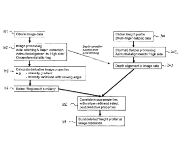
Figure 4 is a flowchart showing steps in a method according to the invention;
Figure 5 illustrates regions of similarity in an image with paths of fingers
of a multi-
finger caliper overlaid; and
Figure 6 illustrates a partial 3D model created by combining 2D image data
from the
image of Figure 5 and linear measurements from a multi-finger caliper tool.
DETAILED DESCRIPTION OF EMBODIMENTS OF THE INVENTION
The method of the present invention combines images of an internal surface of
a
pipe or conduit with physical surface height measurement data to obtain a
higher
resolution 3D model of the internal surface of the structure than that
obtainable from
the measurement data alone.
CA 3027904 2018-12-18
- 8 -
In one embodiment, the method therefore comprises obtaining an image of an
area
of the internal surface of a downhole structure using a downhole logging tool
equipped with a camera, and measuring the height profile of the internal
surface
within sub-regions of the imaged area, for example using a multi-fingered
caliper
tool of the type shown in Figures 1 and 2.
Accordingly, caliper data corresponding to measurements of the internal
diameter
or radius of the pipe are captured using the multi-finger caliper tool. The
caliper tool
may be located on the same logging tool as the camera or may be disposed on a
separate, different logging tool. Each finger of the multi-finger caliper tool
provides
a set of caliper data values that correspond to measurements made as the
finger
moves longitudinally through the pipe, resulting in a set of angularly-spaced
linear
strips of measured height profile data.
The caliper data is then aligned with the image, such that the strips of
linear caliper
data 20 are effectively overlaid onto the image 22 as illustrated in Figure 3.
It is then possible to correlate the measured height profile data with the
image data
in order to construct expected height profile data for parts of the internal
surface that
lie outside the sub-regions of the imaged area for which measured height
profile
data has been obtained. By correlating the measured height profile data with
image
properties derived from the image data, a substantially improved model of the
internal surface of the structure can be obtained compared to simply
extrapolating
the measured height profile data.
In one embodiment, the method uses image processing techniques to identify
parts
of the image between the strips that can be expected to correspond in surface
height
to parts of the image within the strips, so that the physical measurement data
can
be extrapolated to provide a higher resolution model of the surface height of
the
structure across the whole image or across a particular segment or region of
interest
within the image. In this way, a region of the image for which no measurement
data
is available can be matched to a similar region of the image for which
physical
CA 3027904 2018-12-18
- 9 -
measurement data is available, allowing expected height profile data to be
calculated using the relationships established during correlation.
One example of the method will now be described in more detail with reference
to
Figure 4.
In a first step 101, images of the internal surface of a pipe are captured as
a
downhole logging tool or camera tool moves through the pipe. In this example,
the
images are frames of a video stream.
In step 102, the images and related information are processed to produce image
data corresponding to an area of the internal surface of the structure.
For example, overlapping frames of the video can be aligned and stitched
together
to form a composite image of the area of interest. The amount of axial overlap
between video frames gives an estimate of the axial movement and speed of the
logging tool, allowing for the depth at which each frame was captured to be
determined or corrected.
In particular, the video stream consists of a series of images taken at a
predetermined frame rate. By comparing successive images in the video stream,
an
overlap distance between each pair of successive images can be determined.
This
comparison can be made using any suitable image analysis technique, as will be
familiar to those skilled in the art. The speed of movement of the camera tool
at the
.. time at which each image in the video stream was captured can then be
calculated
or estimated from knowledge of the overlap distance and the frame rate. The
depth
position of the image data corresponding to each image can then be determined
by
integrating the speeds with respect to image capture time. The depth position
can
for example be expressed as a distance from a known point in the structure,
such
as the top of the structure or an identifying point disposed along the
structure.
The depth position of the image data could be verified or alternatively
determined
by reference to a depth reading of the logging tool, which may be obtained
from
CA 3027904 2018-12-18
- 10 -
surface depth measurements, a timestamped depth encoder, or via onboard
accelerometer and gyronneter data, as is known in the art.
A further processing step that may be included in step 102 is circumferential
stitching of the images, to provide image data over an area that exceeds the
circumferential angle of view of the camera, preferably around the whole
circumference of the structure.
The processing in step 102 may also include azimuthal alignment of the image
data,
to correct for the tool (and therefore the camera or cameras) being
imperfectly
aligned with the vertical or with the axis of the structure. The azimuthal
alignment of
the tool can be determined for example using a "high side" detector of the
tool, which
indicates the azimuth of the tool that is uppermost at any time, and a
suitable
correction factor can be applied to the image data.
Similarly, the image data may be corrected in step 102 to account for non-
concentricity of the tool.
Step 102 may also involve the application of various image processing
techniques
such as are known in the art to improve contrast, enhance or correct colours,
remove
noise, and so on.
The output of step 102 is a set of corrected and aligned image data relating
to an
area of the internal surface of the structure at a known position.
At step 103, one or more derivative image properties are calculated from the
image
data. For example, an intensity gradient may be calculated for each pixel in
the
image by determining the change in intensity between the subject pixel and one
or
more neighbouring pixels, with each pixel corresponding to a particular
location on
the internal surface of the structure. The rate of change of intensity
gradient could
also be calculated in step 103.
CA 3027904 2018-12-18
-11 -
In another example, a plurality of sets of image data are available for the
same area,
for instance as a result of axially overlapping video frames or
circumferentially
overlapping images from a multiple-camera tool. The sets of image data will
differ
due to the differences in viewing angle from which the area was imaged. It is
therefore possible, in step 103, to calculate the difference in image
intensity for each
location on the internal surface as a result of different viewing angles.
In a further example, a plurality of sets of image data are available for the
same area
in which set of image data has been derived from images taken under different
lighting conditions, such as different lighting angles. In this case, in step
103, the
difference in image intensity is calculated for each location on the internal
surface
as a result of different lighting angles.
At step 104, the image property data is analysed to identify regions of
similarity.
Figure 4 shows an area of the surface of the structure with the position of
three strips
from which caliper data has been obtained. Regions of similarity 24, 26, 28
have
been identified in the image property data. The like-shaded and like-numbered
regions are corresponding regions of similarity. Within each region of
similarity, and
in corresponding regions of similarity, the height of the surface can be
expected to
20 be constant or to follow a functional relationship with one or more of
the derivative
image properties calculated in step 103.
The regions of similarity may be identified by analysis of the derivative
image
properties calculated in step 103. Alternatively, or in addition, the regions
of
similarity may be identified by analysis of other image properties, such as
RGB
values, intensity/brightness, and so on, or by image analysis techniques.
Algorithms that detect regions of similarity in the image property data have
been
developed based on the following categorisation techniques in various
combinations
to improve the level of confidence:
- Grouping pixels together via similarity (in, for example, RGB values and/or
brightness) to reference pixel values corresponding to known or expected
CA 3027904 2018-12-18
- 12 -
features of interest. For example, a range of RGB values corresponding to
rust.
- Pattern matching known reference patterns, such as pitting. This is
done, for
example, using an Eigenspace of reference patterns, providing a dataset of
prominent features of the reference patterns under different conditions
(exposure, lighting, fluid clarity, materials). The reference patterns are
then
used to search the image, and correct matches that fall within a threshold
structural similarity measure are then tagged. Regions of similarity can be
identified with cross correlation with the reference images.
- Image segmentation and blob analysis can be used to identify regular small
features of interest that may correspond, for example, to intrusions into the
structure that signifies pitting.
If a feature of interest spans more than one image, then multiple images may
be
stitched together using known image processing techniques to determine the
full
extent of the feature of interest (and hence the corresponding region of
similarity)
over the surface of the pipe.
The features of interest may, for example, correspond to corrosion pitting,
erosion,
deposits, obstructions, milling features, damage, wear, buckling or
perforations.
Processing of the image data to perform depth corrections, alignments and so
on in
step 102, to calculate image properties in step 103, and/or to determine
regions of
similarity in step 104 may occur in real time in the logging tool, or the raw
images
may be stored in a memory of the logging tool and/or transmitted to a remote
station
for post processing.
Returning to Figure 4, in step 201, physical measurements of the local radius
of the
structure are obtained using a multi-finger caliper tool, for example by
performing a
caliper survey as known in the ad.
At step 202, the raw data from the caliper survey is processed to correct for
azimuthal alignment, eccentricity of the tool and other factors as is
generally known
CA 3027904 2018-12-18
- 13 -
in the art. The resulting measured height profile data comprises a plurality
of sets of
axially-spaced height readings taken along the linear strips 20 of the
surface, with
each strip being angularly spaced from its neighbours.
At step 203, the measured height profile data is aligned with the image data,
so that
the height profile data can be correctly correlated with the image data. If
the caliper
tool and camera are mounted on the same logging tool or tool string, then the
tool
position determined in step 102 by analysis of axially overlapping images can
be
used to determine the depth position of each of the height profile data
points.
If the caliper tool is not mounted on the same tool as the camera, independent
depth
readings from the caliper tool survey can be used to determine the depth
position of
each of the measured height profile data points.
At step 106, the height profile data determined from the caliper measurement
is
correlated with one or more of the image properties within the regions of
similarity
that coincide with the strips or sub-regions of the imaged area for which the
height
profile data is available. Thus, for a plurality of locations on the surface
within each
strip, a measured height profile data point can be matched to the image
properties
derived for from the image data at the corresponding location. A relationship
function
relating the image properties to the measured height profile data is then
determined
for each region of similarity.
At step 107, expected height profile data is calculated for regions of the
imaged area
that lie outside the strips or sub-regions. Within each region of similarity,
the
corresponding relationship function is applied to the image properties for
each pixel
of the image to output an expected height value. In this way, an expected
height
value can be obtained that corresponds to each pixel in an area of interest of
the
image, resulting in the expected height profile data having being
substantially higher
spatial resolution than the measured height profile data obtained from the
caliper
survey.
CA 3027904 2018-12-18
- 14 -
Accordingly, by obtaining measurements from caliper fingers, which provide
accurate measurements along a relatively thin longitudinal slice of the
structure, and
correlating them with the features identified by image processing of the
captured
camera images, a 3D model may be created which accurately represents the
surface morphology of the internal surface of the pipe over the complete
internal
area, as shown in Figure 6. In particular, the method may be used to construct
a
quantitative map or model of pitting and other surface defects and their
severity
across the full area of the surface of the pipe rather than just in the
relatively thin
longitudinal regions covered by caliper data alone.
When assigning height profile data values to a region of similarity that is
not
intersected by the path of a caliper finger, it is preferable to use data
values from
the nearest caliper finger intersecting a corresponding region of similarity.
This
ensures that the caliper data value applied to each region of similarity has
the most
accurate value based on the actual caliper data obtained from measurements in
that
region of the pipe.
The quantitative area coverage data provided by correlating the results of the
image
processing with the caliper data provides far more accurate three dimensional
data
over the surface of a pipe than a traditional linear interpolation of the
caliper data
would provide. Furthermore, simple linear interpolation may also completely
miss
small pitting areas which exist between caliper fingers and which are not
contacted
by the caliper fingers, or pitting areas that have smaller dimensions than the
tip of
the caliper finger is able to access.
Where areas of pitting have been identified in an image, the visual
characteristics
of this section of the image can be noted ¨ for instance, the characteristics
of the
image area relating to the maximum radius or local maxima - and this severity
of
pitting can be interpolated to cover similar areas adjoining the caliper trace
area.
It will be appreciated that, in order to apply caliper data values
consistently across
multiple images, the images can be processed to account for fluid clarity and
uneven
or different lighting conditions. Additional processing of the images may be
used to
CA 3027904 2018-12-18
- 15 -
identify and remove features corresponding to fluid particulates, that might
otherwise be mistaken for features on the surface of the pipe or conduit.
It will also be appreciated that post processing of an image may need to
account for
the logging tool not being located centrally in the pipe or conduit when the
image
was captured. This is required to more accurately determine the
circumferential or
longitudinal dimensions of a defect or feature, which may otherwise be
considered
to be smaller than in reality if the camera lens is further from that region
of the
surface of the pipe or larger if the camera lens is nearer to that region of
the surface
of the pipe.
The method allows different relationship functions to be assigned to different
regions
of similarity, thus improving the accuracy of the expected height profile
data. It is
however conceivable that the step of identifying regions of similarity could
be
omitted, and a single relationship function derived between the measured
height
profile data and the image property data across the whole of the area of
interest.
One example of a possible relationship function is a proportional relationship
between the measured height profile data points and the magnitude of the
intensity
gradient of the image. Another example is a proportional relationship between
the
measured height profile data points and the magnitude of the difference in
image
intensity between images of the same location obtained at different viewing
angles.
Various other relationship functions, involving different image properties,
can be
conceived. In an embodiment, the method includes determining, for each region
of
similarity or for the whole area, a plurality of relationship functions, each
function
relating the measured height profile data to a different image property. The
fit of the
measured data to each function can be assessed statistically and the "best"
function
selected for subsequent calculation of the expected height profile data.
It is envisaged that the method of the invention has specific applications
when
analysing pipes and tubulars for pitting and monitoring the extent of
corrosion.
Utilising the information generated from this method can provide more accurate
corrosion measurements and can thereby provide a more accurate estimation of
CA 3027904 2018-12-18
- 16 -
metal loss from a pipe, casing or other structure. This in turn can be used to
provide
a more accurate estimation of pressure limitations of the corroded, damaged,
worn
or otherwise weakened structure.
Furthermore, the method of the present invention may be used to monitor
evolution
of corrosion or pitting of a pipe surface over time, by directly comparing
image and
caliper data collected at specified time points. In this way, specific
features of
interest may be automatically categorised and detected. With this information,
a
point cloud can be calculated and used to generate an accurate 3D model of the
pipe surface with automatically annotated regions of concern.
It will be appreciated that, while the above description concerns the use of
measurements obtained by a multi-finger caliper tool, in other embodiments
image
data may be combined with data obtained from other mechanical or electrical
sensors. Importantly, the mechanical or electrical sensors provide
quantitative data
or measurements relating to a physical property of the pipe surface that is
not
obtainable through image processing of the captured 2D images of the pipe
internal
surface, but the mechanical or electrical sensors measure the physical
property only
over a limited area of the surface of the pipe.
Although the image data required can most conveniently be obtained from video
data captured as a tool moves through the structure, it will be understood
that the
image data could instead be derived from one or more still images of the
internal
surface of the structure.
Other modifications and variations not explicitly disclosed above may also be
contemplated without departing from the scope of the invention as defined in
the
appended claims.
CA 3027904 2018-12-18