Note: Descriptions are shown in the official language in which they were submitted.
POINT-VECTOR BASED MODELING OF PETROLEUM RESERVOIR PROPERTIES
FOR A GRIDLESS RESERVOIR SIMULATION MODEL
CROSS-REFERENCE TO RELATED APPLICATIONS
[0001] The present application claims priority to U.S. Provisional Application
No.
62/383,311, filed on September 2, 2016, the benefit of which is claimed.
TECHNICAL FIELD
[0002]
The present description relates to reservoir simulation modeling, and
particularly, to
geostatistical modeling and simulation of petroleum reservoir properties.
BACKGROUND
[0003] In the oil and gas industry, geostatistical modeling techniques have
been used to
generate computer models of subsurface reservoir formations within a
hydrocarbon producing
field for purposes of estimating petroleum reserves and making decisions
regarding the
development of the field. Such a model may provide, for example, a static
description of
geological properties of a petroleum reservoir within a subsurface formation
prior to drilling and
production. Traditional models of petroleum reservoir properties generally
require a grid of cells
or blocks for which geological properties are defined or predicted. However,
the grid of cells for
a model imposes constraints on regridding and refinement of current models and
updating the
model with new data. Geological scalability of the model is another concern
with conventional
geostatistical techniques.
SUMMARY OF THE INVENTION
[0004] Embodiments of the present disclosure relate to geomodeling techniques
for
simulating geological properties of a petroleum reservoir in a gridless
manner. As will be
described in further detail below, such techniques may be used to generate
updatable and
scalable geological models without the model regridding and refinement
constraints that are
typically associated with conventional geocellular models. In one or more
embodiments, a
gridless model representing the geological properties of the reservoir may be
generated using
1
Date Recue/Date Received 2021-06-28
vector graphics, rather than rasterized pixels as in conventional geomodeling
and geostatistical
techniques. For example, the reservoir's properties may be represented in a
vector graphics
format that allows the gridless model to provide strict contact boundaries
between different
categorical variables (e.g., lithological facies) as well as strict contour
lines for continuous
variables (e.g. porosity or permeability) or geological elements (e.g. fluvial
channels). The
gridless model in this example may be a two-dimensional (2D) model in which
the contact
boundaries and geological elements are represented in 2D space, e.g., as a set
of connected
vectors or 2D splines. Alternatively, the gridless model may be a three-
dimensional (3D) model
in which the boundaries and geological elements are represented in 3D space,
e.g., as 3D spline
surfaces.
[0005] The disclosed gridless modeling techniques for generating such vector-
based models
are also referred to herein as "point-vector" (or "PV") techniques. Also, the
models generated
using the disclosed techniques may be referred to herein as point-vector or PV
models.
Therefore, it should be appreciated that the terms "gridless" and "point-
vector" are used
interchangeably herein to refer to the disclosed geomodeling techniques as
well as the 2D or 3D
models that are generated in vector graphics format using these techniques.
Advantages of such a
PV model relative to geological models generated using conventional
geostatistical techniques
include, but are not limited to, being infinitely resolvable, resolution
independent, and
geologically scalable. Also, the disclosed techniques may allow such a model
to be generated in
a stochastic manner while ensuring that the underlying data being represented
by the model is
still honored for different geological scales and resolutions, as will be
described in further detail
below.
BRIEF DESCRIPTION OF THE DRAWINGS
[0006] The present disclosure is best understood from the following detailed
description when
read with the accompanying figures.
[0007] FIGS. 1A-B are diagrams illustrating examples of a gridless model and a
gridded
model, respectively.
2
Date Recue/Date Received 2021-06-28
[0008] FIG. 2A is a diagram of an illustrative conditioning data set that may
be used to
generate geological models of reservoir properties with gridless and gridded
modeling
techniques.
[0009] FIGS. 2B-C are diagrams of illustrative gridless and gridded models
generated from
the conditioning data set of FIG. 2A.
[00010] FIG. 3 is a flow diagram of an illustrative process of simulating
geological
properties of a petroleum reservoir using a gridless vector-based or point-
vector (PV) model.
[00011] FIGS. 4A-I are different views of control points and splines
within an illustrative
two-dimensional (2D) vector space at various stages of a point-vector (PV)
simulation
procedure.
[00012] FIGS. 5A-D are different views of another 2D vector space
illustrating how
anisotropy is addressed by the PV simulation procedure of FIGS. 4A-I.
[00013] FIGS. 6A-G are different views of yet another 2D vector space
illustrating
different stages of a procedure for updating a graphical resolution of a
gridless PV model or
updating the gridless PV model with newly acquired conditioning data.
[00014] FIGS. 7A-D are different views of yet another 2D vector space
illustrating a
comparison between generating a PV model that incorporates only primary data
and one that
incorporates a combination of primary and secondary data.
[00015] FIG. 8 is a diagram of illustrative geological units within a
tiered system at
varying scales and zoom levels.
[00016] FIG. 9 is a diagram of illustrative graphical resolutions for
different geological
scales at varying levels of zoom.
[00017] FIGS. 10A-C are diagrams of an illustrative application of PV
techniques for
object based simulation of the growth of fractures and/or fluvial channels
within a reservoir rock
formation as a growing network of connected vectors within a PV model.
[00018] FIG. 11 is a diagram of an illustrative conditioning data set for
a 2D facies
simulation with transitional facies pattern and intrusive facies pattern.
[00019] FIG. 12 is a diagram of an illustrative relationship between
different types of
facies for a transitional facies pattern.
3
Date Recue/Date Received 2021-06-28
[00020] FIG. 13 is a diagram of an illustrative relationship between
different types of
facies for an intrusive facies pattern.
[00021] FIGS. 14A-B are different views of coarse directional polylines
and the resulting
facies model generated from the polylines according to a transitional facies
pattern.
[00022] FIGS. 15A-C are diagrams of intermediate and final facies models
generated
according to an intrusive facies pattern.
[00023] FIG. 16 is a diagram of an illustrative transition of a gridless
model to a gridded
model having a specified structure.
[00024] FIGS. 17A-F are different views of control points and splines
within an
illustrative three-dimensional (3D) vector space at various stages of PV
simulation procedure.
[00025] FIGS. 18A-B are different views of an illustrative spline surface
at various
di scretizati on levels.
[00026] FIG. 19 is a diagram of an illustrative tetrahedralization and
placement of control
points on the edges of tetrahedrons within a 3D vector space.
[00027] FIG. 20 is a block diagram illustrating an example of a computer
system in which
embodiments of the present disclosure may be implemented.
DETAILED DESCRIPTION
[00028] Embodiments of the present disclosure relate to modeling
geological properties of
a petroleum reservoir using a gridless reservoir simulation model. While the
present disclosure is
described herein with reference to illustrative embodiments for particular
applications, it should
be understood that embodiments are not limited thereto. Other embodiments are
possible, and
modifications can be made to the embodiments within the spirit and scope of
the teachings
herein and additional fields in which the embodiments would be of significant
utility. Further,
when a particular feature, structure, or characteristic is described in
connection with an
embodiment, it is submitted that it is within the knowledge of one skilled in
the relevant art to
effect such feature, structure, or characteristic in connection with other
embodiments whether or
not explicitly described.
[00029] It would also be apparent to one of skill in the relevant art that
the embodiments,
as described herein, can be implemented in many different embodiments of
software, hardware,
firmware, and/or the entities illustrated in the figures. Any actual software
code with the
4
Date Recue/Date Received 2021-06-28
specialized control of hardware to implement embodiments is not limiting of
the detailed
description. Thus, the operational behavior of embodiments will be described
with the
understanding that modifications and variations of the embodiments are
possible, given the level
of detail presented herein.
[00030] In the detailed description herein, references to "one or more
embodiments," "an
embodiment,- "an example embodiment,- etc., indicate that the embodiment
described may
include a particular feature, structure, or characteristic, but every
embodiment may not
necessarily include the particular feature, structure, or characteristic.
Moreover, such phrases are
not necessarily referring to the same embodiment. Further, when a particular
feature, structure,
or characteristic is described in connection with an embodiment, it is
submitted that it is within
the knowledge of one skilled in the art to effect such feature, structure, or
characteristic in
connection with other embodiments whether or not explicitly described.
[00031] Illustrative embodiments and related methodologies of the present
disclosure are
described below in reference to FIGS. 1-20 as they might be employed, for
example, in a
computer system for planning and control of wellsite operations. For example,
the disclosed
techniques may be employed in such a computer system to generate a PV model of
a reservoir
rock formation's geological properties and use the generated model to estimate
the petroleum
reserves of the formation or to simulate propagation of induced fractures in a
fracking process of
the reservoir rock. Another application of the generated PV model is to
simulate the flow of
fluids (e.g., oil and/or water) within the reservoir formation presented by
this PV model. The
results of the simulation may then be used to perform various wellsite
operations including, for
example and without limitation, well placement, production planning, and/or
stimulation
planning purposes. Other features and advantages of the disclosed embodiments
will be or will
become apparent to one of ordinary skill in the art upon examination of the
following figures and
detailed description. It is intended that all such additional features and
advantages be included
within the scope of the disclosed embodiments. Further, the illustrated
figures are only
exemplary and are not intended to assert or imply any limitation with regard
to the environment,
architecture, design, or process in which different embodiments may be
implemented.
[00032] FIGS. 1A and IB are diagrams of an illustrative gridless model
100A and an
illustrative gridded model 100B, respectively. Each of the models shown in
FIGS. 1A and IB
Date Recue/Date Received 2021-06-28
may be, for example, a 2D geological model representing different categories
of geological
properties for a subsurface volume of a reservoir rock formation. However, it
is assumed for
purposes of this example that gridless model 100A of FIG. 1A was generated
using the PV
techniques disclosed herein while gridded model 100B was generated using
conventional
geocellular modeling techniques. Such conventional modeling techniques
typically utilize a grid
having a regular spatial arrangement of cells, e.g., corresponding to
different points in a 2D
coordinate space, where each cell may be assigned geological properties of a
corresponding
portion of the reservoir formation based on its relative spatial position
within the grid. However,
as the grid of cells and values assigned to each cells of gridded model 100B
typically impose
various constraints on the resolution and scalability of the model.
[00033] By contrast, gridless model 100A generated using the PV techniques
disclosed
herein may be used to represent the reservoir formation's rock and fluid
properties without a
predetermined grid or the resolution and scalability constraints associated
with gridded model
100B. Also, as described above, the PV techniques disclosed herein enable
geological properties
to be represented in a vector graphics format rather than with rasterized
pixels, as in gridded
models generated using conventional geostatistical modeling techniques. This
allows gridless
models, e.g., gridless model 100A, generated using the disclosed techniques to
represent a
reservoir's geological properties in a resolution-independent way, as will be
described below
with respect to the example shown in FIGS. 2A, 2B, and 2C.
[00034] FIG. 2A is a diagram of an illustrative conditioning data set 200A
for different
categories of geological properties. Conditioning data set 200A may be applied
to a gridless or
gridded model according to a given graphical resolution of interest. FIGS. 2B-
C are diagrams
illustrating a graphical resolution of a gridless model 200B and a gridded
model 200C,
respectively, based on the conditioning data set of FIG. 2A. A comparison
between the different
resolutions of the models as shown in FIGS. 2B and 2C indicates that while
gridless model 200B
of FIG. 2B has continuous boundaries between categories, gridded model 200C of
FIG. 2C has a
rasterized modeling domain in which the categories are defined for individual
cells on a pixel-
by-pixel (or cell-by-cell) basis. Thus, the gridless modeling techniques
disclosed herein allow
gridless models, e.g., gridless model 200B, to provide a more accurate or
realistic representation
of modeled petroleum reservoir properties.
6
Date Recue/Date Received 2021-06-28
[00035] As described above, the reservoir's properties may be represented
in a vector
graphics format that allows the gridless model to provide strict contact
boundaries between
different categorical variables (e.g., lithological facies) as well as strict
contour lines for
continuous variables (e.g. porosity or permeability) or geological elements
(e.g. fluvial
channels). In one or more embodiments, the disclosed PV techniques may be used
to construct
contact boundaries between categories or contour lines of continuous variables
for either 2D or
3D models with only slight variations. In one or more embodiments, contact
boundaries between
different categories may be constructed as polylines in 2D space or as meshed
surfaces in 3D
space that would form objects of distinct categories.
[00036] In 2D space, the disclosed PV techniques may be used to simulate
connected
vectors of approximately equal magnitude that represent the boundaries between
different classes
of properties of natural phenomena (e.g., categories, intervals of continuous
properties, etc.) or
the different classes themselves (e.g., river channels, fractures, faults,
etc.). Such vectors may
form polylines that follow the path determined by the data distribution. The
triangulation of the
data may be required to establish this path. The polyline formed by simulated
vectors can be
replaced with spline curves (e.g. Hermite splines). In 3D space, spline
surfaces may be simulated
as part of the disclosed PV techniques for purposes of drawing the boundaries
between
categories. Thus, the disclosed PV techniques may be used to build geological
surfaces,
structural elements, lithological facies, and continuous properties of the
petroleum reservoirs in a
grid-free manner. The surface boundaries in 3D space are generated with spline
surfaces. Such
techniques may also be used to generate multiple realizations as needed or
desired for a
particular implementation.
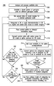
[00037] FIG. 3 is a flow diagram of an illustrative process 300 of
generating a gridless or
PV model for simulating geological properties of a petroleum reservoir. The PV
model generated
in this example may be either a 2D model or a 3D model. Accordingly, process
300 will be
described with respect to operations for both 2D and 3D models. As shown in
FIG. 3, process
300 begins in block 302, in which data from various sources is analyzed and
processed.
Examples of such data sources include, but are not limited to, core samples,
well log data,
seismic data, and geological interpretations.
7
Date Recue/Date Received 2021-06-28
[00038] In block 304, a tiered system or hierarchy of geological units
(e.g., lithological
facies) is established for various geological scales. The different geological
scales may include,
for example and without limitation, a basin scale, a depositional scale, and a
reservoir scale. An
example of such a tiered hierarchy is shown in FIG. 9, which will be described
in further detail
below. In one or more embodiments, the different geological scales and
geological units within
each scale in the tiered hierarchy for a gridless model may be associated with
a plurality of
graphical resolutions at different zoom levels. The plurality of graphical
resolutions may include,
for example, a coarse resolution and a fine resolution as well as a range of
resolutions that vary
between the coarse and fine resolutions. The geological scale of each
geological unit in the tiered
hierarchy also may vary between a range of coarse and fine scales. A
geological unit of relatively
coarse scale in the tiered system may include, for example, one or several
geological units of
relatively finer scale. Thus, block 304 may also include defining a
relationship between
geological units within each scale. In some implementations, block 304 may
further include
selecting data for conditioning the model given a particular graphical scale
of interest.
[00039] In block 306, pseudo-data are added at locations corresponding to
the domain
margins of the PV model being generated. The pseudo-data may be added to fill
in any gaps
between the domain boundaries and adjacent data values. Additional pseudo-data
are added at
model's corner points. In cases where spatial continuity of the modeled system
is less than data
density, the pseudo-data may also be added between the original data
locations. In one or more
embodiments, block 306 may include simulating values for the added pseudo-data
based on an
initial set of conditioning data and the spatial distribution of the data.
Multiple realizations of the
pseudo-data may also be generated in block 306.
[00040] Process 300 then proceeds to block 308, which includes
triangulating data points
in 2D space or applying tetrahedralization to points in 3D space corresponding
to the original
and added data values at the modeling domain margins.
[00041] In block 310, control points may be placed on the edges of the
triangles/tetrahedrons formed by the triangulation/tetrahedralization
performed in block 308. The
control points may be placed primarily on the edges that connect two different
data types. The
control points may be placed so as to preserve the spatial distribution of the
reservoir system
being modeled and any anisotropy that may be present within the modeled
categories or
8
Date Recue/Date Received 2021-06-28
domains. By implementing triangulation/tetrahedralization in various ways and
placing control
points on the edges of resulting triangles/tetrahedrons in different patterns,
data reproduction
may be ensured in the final PV model that is generated. In one or more
embodiments, block 310
may also include generating multiple realizations as needed or desired for a
particular
implementation.
[000421 In block 312, the control points that were placed in step 310 are
connected with
spline curves for a 2D PV model or spline surfaces for 3D PV models. The
control points are
used as anchor points to derive connected vectors or splines of a selected
discretization level.
These polylines form contact boundaries between categories. The magnitude of
the vectors or
discretization level of the splines may represent, for example, a resolution
of contact boundaries.
[00043] In block 314, local variability is added to the spline
curves/surfaces in order to
avoid over-smoothed contact boundaries. Multiple realizations may be generated
this way,
although their spatial connectivity would not differ much from each other. The
control points
may be adjusted in block 314 to ensure that no contact boundaries cross one
another.
[00044] In block 316, splines are converted into categorical objects
including a set of
polygons for a 2D model or a set of surfaces for a 3D model.
[00045] In block 318, it is determined whether or not the simulated or
modeled
proportions of modeled categories based on the control points adjusted in
block 314 above match
target proportions, e.g., within a predetermined error tolerance. If it is
determined in block 318
that the simulated/modeled proportions fail to match the target proportions,
process 300 proceeds
to block 320, where the control points may be further adjusted accordingly and
process 300
returns to block 314. However, if it is determined in block 318 that the
simulated/modeled
proportions match the target proportions, process 300 proceeds to block 322.
[00046] In block 322, it is determined whether any new data needs to be
incorporated into
the current PV model or whether there are any changes to the current graphical
resolution
specified for the current model at this stage of the process. If it is
determined in block 320 that
either the graphical resolution has changed or the current PV model needs to
be updated with
new data (e.g., additional conditioning data for a visual representation of
the PV model to be
displayed or recently acquired conditioning data from a newly drilled well),
process 300 returns
to block 308 and the operations in blocks 308, 310, 312, 314, 316, 318, 320
(if necessary), and
9
Date Recue/Date Received 2021-06-28
322 are repeated. In one or more embodiments, the current model may be
maintained so as to
preserve the previous results of the triangulation/tetrahedralization and the
operations in the
blocks 308 through 322 are repeated with the new data. For example, new
triangles/tetrahedrons
may be introduced based on the triangulation/tetrahedralization of the new
data at block 308
while keeping original triangles/tetrahedrons unchanged. However, if it is
determined in block
322 that the graphical resolution has not changed and that no new data needs
to be incorporated
into the current PV mode, process 300 proceeds to block 324.
[00047] Block 324 includes determining whether or not the geological scale
specified for
the current PV model has changed. If it is determined in block 324 that the
geological scale has
changed, process 300 returns to block 306 and the operations in blocks 306,
308, 310, 312, 314,
316, 318, 320 (if necessary), 322, and 324 are repeated. The operations in
these blocks may be
repeated with different model categories at finer geological scales that are
related to the
relatively coarse scale of the previous model categories. Otherwise, process
300 proceeds to
block 326, in which the current PV model is made final and used to simulate
reservoir conditions
for well planning and production operations.
[00048] Additional features and characteristics of the PV techniques
disclosed herein will
now be described in reference to the examples illustrated in FIGS. 4A-19.
Although the
examples in FIGS. 4A-16 will be described using 2D models, it should be
appreciated that the
disclosed PV techniques are not intended to be limited thereto and that these
techniques may be
applied to 3D models, as will be described with respect to FIGS. 17A-19. For
discussion
purposes and ease of explanation, it will be assumed that the PV models
illustrated in FIGS. 4A-
17F include only two categories of geological units or elements. In FIGS. 4A-
7D and 17A-17F
in particular, each element is shown as either a square-shaped or triangle-
shaped data point
within a 2D space depending on the category to which the particular element
belongs. It should
be appreciated that while different shapes are used to different the data
points, regions, or other
features of the geological categories represented in these figures, it should
be appreciated that the
disclosed embodiments are not limited thereto and that any of various
visualization techniques
may be used instead. For example, such categories may be illustrated using
different patterns,
colors or other type of visualization to differentiate the corresponding data
points.
Date Recue/Date Received 2021-06-28
[00049] However, it should be noted that the disclosed PV techniques are
not intended to
be limited to only two categories and that these techniques may be applied to
PV models
including any number of categories of geological elements.
[00050] FIGS. 4A-I illustrate an application of the PV techniques for
generating a gridless
model with two categories of geological elements (square vs. triangle-shaped
points). In FIG.
4A, the data for the model is defined. In FIG. 4B, the pseudo-data are added
at the model
margins and model corners. The values of pseudo-data are simulated conditional
to original data
and their spatial distribution. In FIG. 4C, triangulation is performed with
all original and pseudo-
data locations. In FIG. 4D, control points (circle-shaped points) are located
on the triangle edges
that connect two different categories. In FIG. 4E, the locations of control
points can be randomly
drawn from the triangular distribution between two data locations of different
categories. In FIG.
4F, the control points are connected with splines to define contact boundaries
between
categories. In FIG. 4G, the categorical objects are defined with splines. In
FIG. 4H, the local
variations are added to avoid excessive smoothness of the PV model. The
variability may be
added by, for example, perturbing splines at their discretization points. In
FIG. 41, the control
points are adjusted to match target proportions of the categories. Proportions
may be adjusted
using an optimization algorithm, for example, with simulated annealing.
[00051] The examples shown in FIGS. 5A-D highlight how anisotropy is
addressed by the
PV simulation procedure of FIGS. 4A-I. When correlation range is shorter than
length of the
triangulation edge, several control points should be simulated per an edge. An
anisotropy ellipse
of the correlation structure of the modeled system is shown in FIG. 5A that
leads to control
points distributed around one of the categories of elements, e.g., as
represented by the triangle-
shaped data points shown in FIGS. 5B and 5C. As indicated by the question
marks in FIG. 5C,
the PV model may be more continuous in the horizontal direction than necessary
or desired.
Therefore, additional control points may be added per edge in order to create
additional
categorical objects or interrupt existing boundaries as shown in FIG. 5D.
[00052] FIGS. 6A-G are different views of yet another 2D vector space
illustrating
different stages of a procedure for updating a graphical resolution of a
gridless PV model or
incorporating newly acquired conditioning data into the model.
11
Date Recue/Date Received 2021-06-28
[00053] Examples of updating the model with new data and changing the
model's
graphical resolution using the disclosed PV techniques are shown in FIGS. 6A-
G. In each of
FIGS. 6A-G, the original or initial PV model is shown on the left-hand side
and the updated
model is shown on right-hand side. In FIG. 6A, data are defined. In FIG. 6B,
marginal pseudo-
data are simulated. Original pseudo-data are preserved in the updated model.
In FIG. 6C,
triangulation is performed. Triangulation in the updated model is performed
after triangulation of
the original data is carried out. In FIG. 6D, control points are placed. The
location of original
control points is preserved. In FIG. 6E, control points are connected by
splines. In FIG. 6F,
categorical objects are produced. In FIG. 6G, local variability is added.
[00054] In one or more embodiments, secondary data may be used to
additionally
constrain where a contact boundary is drawn in the PV model. FIGS. 7A-D show a
comparison
between a first PV model (on the left hand side) that incorporates only
primary data relative to a
second PV model (on the right hand side) that incorporates both primary and
secondary data
types, where the secondary data is in the form of a regional map. In FIG. 7A,
the primary and
secondary data are shown. The secondary data in this example are represented
by a contact
boundary of various uncertainties between two categories. The contact boundary
may be
available with relatively little or no uncertainty in the upper part of the
model. However, the
uncertainty in the contact boundary may increase for locations further from
the upper part of the
model and closer to the lower part. In FIG. 7B, marginal data are introduced,
and control points
are located. In FIG. 7C, the splines are drawn. In FIG. 7D, the simulated
objects of categories are
obtained.
[00055] The scalability of PV model is ensured by a tiered system of
geological units. The
underlying concept is shown in FIG. 8. In this example, coarse (basin), medium
(depositional),
and fine (reservoir) scales are defined. The geological units of finer scale
are elements of
geological units at coarse scale. This consistency should be preserved in the
PV models.
[00056] In a graphical implementation of PV, both scalability and change
in the graphical
resolution should be taken into account. The zooming in/out feature of the PV
method is depicted
in FIG. 9. Each geological scale consists of several graphical resolutions.
The model is updated
from coarse scale to fine scale both for geological scale and graphical
resolution as described
12
Date Recue/Date Received 2021-06-28
above in a series of examples when the PV model is zoomed in for higher
resolution and finer
geological scale.
[00057] FIGS. 10A-C present how the above-described PV techniques may be
used to
simulate not only contact boundaries between categories, but geological
objects directly in the
form of polylines as fluvial channels or fracture network by growing network
of connected
vectors. The model shown in FIG. 10A may be generated using a multiple-point
statistics (MPS)
procedure and is provided for comparison purposes. The resulting PV model as
shown in FIG.
10C may be generated by updating the PV model as shown in FIG. 10B using the
gridless/PV
techniques disclosed herein tend to be more geologically realistic than models
generated with
conventional geostatistical simulation methods, e.g. with sequential indicator
simulation (SIS) or
1\,/iPS. The simulated geological objects have higher connectivity in PV
models in comparison
with conventional geostatistical categorical models, as illustrated in FIGS.
10A and 10C.
[00058] The geostatistical categories in a petroleum application usually
represent
lithological facies, which can be deposited in simple stacking pattern called
transitional
depositional rule or in more complex intrusive way. These facies relationships
are possible to
model with PV. A 2D example of PV fluvial models generated according to
stacking and
intrusive patterns is provided. The transitional type of deposition has been
described in all
examples above. The intrusive type of deposition is stressed out in this
example.
[00059] FIG. ibis a diagram of an illustrative conditioning data set for
different facies
types, including a background facies, channel facies, and levee facies.
Although only three types
of facies are shown in FIG. 11, it should be appreciated that embodiments are
not intended to be
limited thereto and the PV techniques disclosed herein may be applied to any
number of facies
types. FIG. 12 illustrates a relationship between the different facies types
of FIG. 11 for a
transitional facies pattern. FIG. 13 illustrates a relationship between the
different facies types for
an intrusive facies pattern.
[00060] FIGS. 14A-B are different views of coarse directional polylines
and the resulting
facies model generated from the polylines according to a stacking facies
pattern.
[00061] FIGS. 15A-C are diagrams of intermediate and final facies models
generated
according to an intrusive facies pattern. The final PV models in this example
may honor data
values and exhibit imposed relationship between lithological facies either in
transitional or
13
Date Recue/Date Received 2021-06-28
intrusive forms. The intrusive type depositional environments may be generated
as follows: first,
categories for modeling are defined and grouped according to their
depositional relationship,
where, as shown in FIG. 13, facies associations that consist of transitional
facies (e.g.,
background and channel facies) may be defined along with intrusive facies
(e.g., levee facies);
models for each of the defined facies associations, including a model for the
transitional facies
and another model for the intrusive facies (as shown in FIGS. 15A and 15B,
respectively), are
generated based on the disclosed PV simulation procedure or technique; and the
two models (the
transitional facies model and the intrusive facies model) are merged together
into a single PV
model (as shown in FIG. 15C).
[00062] In one or more embodiments, the generated PV model may be used
further for
flow simulation and reservoir forecasting. Imposing a grid on the top of the
PV model may be
relatively straightforward for any arbitrary (regular or irregular) grid
structure, as shown in the
example of FIG. 16. The inclusion of such a grid may be required for
subsequent flow simulation
in certain cases. The PV model with strict contact boundaries is averaged over
the imposed grid.
This process is similar to the upscaling procedure of geological facies,
where, for instance, the
facies with the largest proportion within the grid cell is assigned to this
entire grid cell.
[00063] As will be described in further detail below, only slight changes
to the above-
described PV techniques for generating 2D models may be needed for generating
3D models.
For example, the triangulation performed for 2D models may be replaced with
tetrahedralization
in 3D space. Spline curves may be replaced with spline surfaces to draw
contact boundaries
between categories in 3D.
[00064] FIGS. 17A-F illustrate a workflow for using the PV techniques to
generate a 3D
PV model of a reservoir formation. In FIG. 17A, data for the 3D model is
defined. In FIG. 17B,
tetrahedralization is performed. In FIG. 17C, control points are drawn on the
tetrahedron edges
that connect data of different values. In FIG. 17D, spline surfaces are
generated that go through
the control points. In FIGS. 18A and 18B, examples of such a spline surface
(e.g., a Hermite
spline surface) are shown at different discretization levels, e.g., coarse and
fine, respectively. In
FIG. 17E, local variability is added to overcome smoothness of the contact
boundaries. In FIG.
17F, categorical objects are defined through spline surfaces.
14
Date Recue/Date Received 2021-06-28
[00065] FIG. 19 illustrates the placement rule with respect to control
points for transitional
depositional type of lithological facies. As shown in FIG. 19, control points
are placed on the
edges of tetrahedrons resulting from a tetrahedralization of data in 3D space.
[00066] FIG. 20 is a block diagram illustrating an example of a computer
system 2000 in
which embodiments of the present disclosure may be implemented. For example,
process 300 of
FIG. 3, as described above, may be implemented using system 2000. System 2000
can be a
computer, phone, personal digital assistant device (PDA), or any other type of
electronic device.
Such an electronic device includes various types of computer readable media
and interfaces for
various other types of computer readable media. As shown in FIG. 20, system
2000 includes a
permanent storage device 2002, a system memory 2004, an output device
interface 2006, a
system communications bus 2008, a read-only memory (ROM) 2010, processing
unit(s) 2012, an
input device interface 2014, and a network interface 2016.
[00067] Bus 2008 collectively represents all system, peripheral, and
chipset buses that
communicatively connect the numerous internal devices of system 2000. For
instance, bus 2008
communicatively connects processing unit(s) 2012 with ROM 2010, system memory
2004, and
permanent storage device 2002.
[00068] From these various memory units, processing unit(s) 2012 retrieves
instructions to
execute and data to process in order to execute the processes of the subject
disclosure. The
processing unit(s) can be a single processor or a multi-core processor in
different
implementations.
[00069] ROM 2010 stores static data and instructions that are needed by
processing unit(s)
2012 and other modules of system 2000. Permanent storage device 2002, on the
other hand, is a
read-and-write memory device. This device is a non-volatile memory unit that
stores instructions
and data even when system 2000 is off. Some implementations of the subject
disclosure use a
mass-storage device (such as a magnetic or optical disk and its corresponding
disk drive) as
permanent storage device 2002.
[00070] Other implementations use a removable storage device (such as a
floppy disk,
flash drive, and its corresponding disk drive) as permanent storage device
2002. Like permanent
storage device 2002, system memory 2004 is a read-and-write memory device.
However, unlike
storage device 2002, system memory 2004 is a volatile read-and-write memory,
such a random
Date Recue/Date Received 2021-06-28
access memory. System memory 2004 stores some of the instructions and data
that the processor
needs at runtime. In some implementations, the processes of the subject
disclosure are stored in
system memory 2004, permanent storage device 2002, and/or ROM 2010. For
example, the
various memory units include instructions for computer aided pipe string
design based on
existing string designs in accordance with some implementations. From these
various memory
units, processing unit(s) 2012 retrieves instructions to execute and data to
process in order to
execute the processes of some implementations.
[0007/] Bus 2008 also connects to input and output device interfaces 2014
and 2006.
Input device interface 2014 enables the user to communicate information and
select commands
to the system 2000. Input devices used with input device interface 2014
include, for example,
alphanumeric, QWERTY, or T9 keyboards, microphones, and pointing devices (also
called
"cursor control devices"). Output device interfaces 2006 enables, for example,
the display of
images generated by the system 2000. Output devices used with output device
interface 2006
include, for example, printers and display devices, such as cathode ray tubes
(CRT) or liquid
crystal displays (LCD). Some implementations include devices such as a
touchscreen that
functions as both input and output devices. It should be appreciated that
embodiments of the
present disclosure may be implemented using a computer including any of
various types of input
and output devices for enabling interaction with a user. Such interaction may
include feedback to
or from the user in different forms of sensory feedback including, but not
limited to, visual
feedback, auditory feedback, or tactile feedback. Further, input from the user
can be received in
any form including, but not limited to, acoustic, speech, or tactile input.
Additionally, interaction
with the user may include transmitting and receiving different types of
information, e.g., in the
form of documents, to and from the user via the above-described interfaces.
[00072] Also, as shown in FIG. 20, bus 2008 also couples system 2000 to a
public or
private network (not shown) or combination of networks through a network
interface 2016. Such
a network may include, for example, a local area network ("LAN"), such as an
Intranet, or a wide
area network ("WAN"), such as the Internet. Any or all components of system
2000 can be used
in conjunction with the subject disclosure.
[00073] These functions described above can be implemented in digital
electronic
circuitry, in computer software, firmware or hardware. The techniques can be
implemented using
16
Date Recue/Date Received 2021-06-28
one or more computer program products. Programmable processors and computers
can be
included in or packaged as mobile devices. The processes and logic flows can
be performed by
one or more programmable processors and by one or more programmable logic
circuitry.
General and special purpose computing devices and storage devices can be
interconnected
through communication networks.
[000741 Some implementations include electronic components, such as
microprocessors,
storage and memory that store computer program instructions in a machine-
readable or
computer-readable medium (alternatively referred to as computer-readable
storage media,
machine-readable media, or machine-readable storage media). Some examples of
such computer-
readable media include RAM, ROM, read-only compact discs (CD-ROM), recordable
compact
discs (CD-R), rewritable compact discs (CD-RW), read-only digital versatile
discs (e.g., DVD-
ROM, dual-layer DVD-ROM), a variety of recordable/rewritable DVDs (e.g., DVD-
RAM,
DVD-RW, DVD+RW, etc.), flash memory (e.g., SD cards, mini-SD cards, micro-SD
cards, etc.),
magnetic and/or solid state hard drives, read-only and recordable Blu-Ray
discs, ultra density
optical discs, any other optical or magnetic media, and floppy disks. The
computer-readable
media can store a computer program that is executable by at least one
processing unit and
includes sets of instructions for performing various operations. Examples of
computer programs
or computer code include machine code, such as is produced by a compiler, and
files including
higher-level code that are executed by a computer, an electronic component, or
a microprocessor
using an interpreter.
[00075] While the above discussion primarily refers to microprocessor or
multi-core
processors that execute software, some implementations are performed by one or
more integrated
circuits, such as application specific integrated circuits (ASICs) or field
programmable gate
arrays (FPGAs). In some implementations, such integrated circuits execute
instructions that are
stored on the circuit itself. Accordingly, process 300 of FIG. 3, as described
above, may be
implemented using system 2000 or any computer system having processing
circuitry or a
computer program product including instructions stored therein, which, when
executed by at
least one processor, causes the processor to perform functions relating to
these methods.
[00076] As used in this specification and any claims of this application,
the terms
"computer", "server", "processor", and "memory" all refer to electronic or
other technological
17
Date Recue/Date Received 2021-06-28
devices. These terms exclude people or groups of people. As used herein, the
terms "computer
readable medium" and "computer readable media" refer generally to tangible,
physical, and non-
transitory electronic storage mediums that store information in a form that is
readable by a
computer.
[00077] Embodiments of the subject matter described in this specification
can be
implemented in a computing system that includes a back end component, e.g., as
a data server, or
that includes a middleware component, e.g., an application server, or that
includes a front end
component, e.g., a client computer having a graphical user interface or a Web
browser through
which a user can interact with an implementation of the subject matter
described in this
specification, or any combination of one or more such back end, middleware, or
front end
components. The components of the system can be interconnected by any form or
medium of
digital data communication, e.g., a communication network. Examples of
communication
networks include a local area network ("LAN") and a wide area network ("WAN"),
an inter-
network (e.g., the Internet), and peer-to-peer networks (e.g., ad hoc peer-to-
peer networks).
[00078] The computing system can include clients and servers. A client and
server are
generally remote from each other and typically interact through a
communication network. The
relationship of client and server arises by virtue of computer programs
running on the respective
computers and having a client-server relationship to each other. In some
embodiments, a server
transmits data (e.g., a web page) to a client device (e.g., for purposes of
displaying data to and
receiving user input from a user interacting with the client device). Data
generated at the client
device (e.g., a result of the user interaction) can be received from the
client device at the server.
[00079] It is understood that any specific order or hierarchy of steps in
the processes
disclosed is an illustration of exemplary approaches. Based upon design
preferences, it is
understood that the specific order or hierarchy of steps in the processes may
be rearranged, or
that all illustrated steps be performed. Some of the steps may be performed
simultaneously. For
example, in certain circumstances, multitasking and parallel processing may be
advantageous.
Moreover, the separation of various system components in the embodiments
described above
should not be understood as requiring such separation in all embodiments, and
it should be
understood that the described program components and systems can generally be
integrated
together in a single software product or packaged into multiple software
products.
18
Date Recue/Date Received 2021-06-28
[00080] Furthermore, the exemplary methodologies described herein may be
implemented
by a system including processing circuitry or a computer program product
including instructions
which, when executed by at least one processor, causes the processor to
perform any of the
methodology described herein.
[00081] As described above, embodiments of the present disclosure are
particularly useful
for modeling petroleum reservoir properties. In one embodiment of the present
disclosure, a
method of modeling petroleum reservoir properties includes: analyzing data
relating to
geological properties of a reservoir formation; generating a tiered hierarchy
of geological
elements within the reservoir formation at different geological scales, based
on the analysis;
categorizing the geological elements at each of the different geological
scales in the tiered
hierarchy; defining spatial boundaries between the categorized geological
elements for each of
the geological scales in the tiered hierarchy; and generating a gridless model
of the reservoir
formation, based on the spatial boundaries defined for at least one of the
geological scales in the
tiered hierarchy. In another embodiment of the present disclosure, a computer-
readable storage
medium having instructions stored therein is disclosed, where the
instructions, when executed by
a computer, cause the computer to perform a plurality of functions, including
functions to:
analyze data relating to geological properties of a reservoir formation;
generate a tiered hierarchy
of geological elements within the reservoir formation at different geological
scales, based on the
analysis; categorize the geological elements at each of the different
geological scales in the tiered
hierarchy; define spatial boundaries between the categorized geological
elements for each of the
geological scales in the tiered hierarchy; and generate a gridless model of
the reservoir
formation, based on the spatial boundaries defined for at least one of the
geological scales in the
tiered hierarchy.
[00082] One or more embodiments of the foregoing method and/or computer-
readable
storage medium may further include any one or any combination of the following
additional
elements, functions or operations: simulating fluid flow within the reservoir
formation, based on
the gridless model of the reservoir formation; the gridless model may be a two-
dimensional (2D)
model of the reservoir formation in a vector graphics format and the spatial
boundaries between
the categorized geological elements may be defined as polylines in 2D space;
the gridless model
may be a three-dimensional (3D) model of the reservoir formation in a vector
graphics format
19
Date Recue/Date Received 2021-06-28
and the spatial boundaries between the categorized geological elements may be
defined as spline
surfaces in 3D space; the data may be obtained from one or more data sources;
the one or more
data sources may include one or more of a core sample, a well log, seismic
data log, and a
geological interpretation. In one or more embodiments of the foregoing method
and/or computer-
readable storage medium, each of the different geological scales of the
gridless model may be
associated with a plurality of graphical resolutions at different zoom levels.
In one or more
embodiments of the foregoing method and/or computer-readable storage medium,
the different
geological scales may include a basin scale, a depositional scale, and a
reservoir scale, and the
plurality of graphical resolutions include a range of resolutions varying
between a coarse
resolution and a fine resolution.
[00083] Furthermore, a system is disclosed, where the system includes at
least one
processor and a memory coupled to the processor having instructions stored
therein, which when
executed by the processor, cause the processor to perform functions including
functions to:
analyze data relating to geological properties of a reservoir formation;
generate a tiered hierarchy
of geological elements within the reservoir formation at different geological
scales, based on the
analysis; categorize the geological elements at each of the different
geological scales in the tiered
hierarchy; define spatial boundaries between the categorized geological
elements for each of the
geological scales in the tiered hierarchy; generate a gridless model of the
reservoir formation,
based on the spatial boundaries defined for at least one of the geological
scales in the tiered
hierarchy; and simulate fluid flow within the reservoir formation, based on
the gridless model of
the reservoir formation.
[00084] In one or more embodiments of the foregoing system, the gridless
model may be a
two-dimensional (2D) model of the reservoir formation in a vector graphics
format and the
spatial boundaries between the categorized geological elements may be defined
as polylines in
2D space. Alternatively, the gridless model may be a three-dimensional (3D)
model of the
reservoir formation in a vector graphics format, and the spatial boundaries
between the
categorized geological elements may be defined as spline surfaces in 3D space.
Further, the data
may be obtained from one or more data sources, where the one or more data
sources may include
one or more of a core sample, a well log, seismic data log, and a geological
interpretation. In one
or more embodiments of the foregoing system, each of the different geological
scales of the
Date Recue/Date Received 2021-06-28
gridless model may be associated with a plurality of graphical resolutions at
different zoom
levels. In one or more embodiments of the foregoing system, the different
geological scales may
include a basin scale, a depositional scale, and a reservoir scale, and the
plurality of graphical
resolutions include a range of resolutions varying between a coarse resolution
and a fine
resolution.
[00085] While specific details about the above embodiments have been
described, the
above hardware and software descriptions are intended merely as example
embodiments and are
not intended to limit the structure or implementation of the disclosed
embodiments. For instance,
although many other internal components of the system 2000 are not shown,
those of ordinary
skill in the art will appreciate that such components and their
interconnection are well known.
[00086] In addition, certain aspects of the disclosed embodiments, as
outlined above, may
be embodied in software that is executed using one or more processing
units/components.
Program aspects of the technology may be thought of as "products" or "articles
of manufacture"
typically in the form of executable code and/or associated data that is
carried on or embodied in a
type of machine readable medium. Tangible non-transitory "storage" type media
include any or
all of the memory or other storage for the computers, processors or the like,
or associated
modules thereof, such as various semiconductor memories, tape drives, disk
drives, optical or
magnetic disks, and the like, which may provide storage at any time for the
software
programming.
[00087] Additionally, the flowchart and block diagrams in the figures
illustrate the
architecture, functionality, and operation of possible implementations of
systems, methods and
computer program products according to various embodiments of the present
disclosure. It
should also be noted that, in some alternative implementations, the functions
noted in the block
may occur out of the order noted in the figures. For example, two blocks shown
in succession
may, in fact, be executed substantially concurrently, or the blocks may
sometimes be executed in
the reverse order, depending upon the functionality involved. It will also be
noted that each block
of the block diagrams and/or flowchart illustration, and combinations of
blocks in the block
diagrams and/or flowchart illustration, can be implemented by special purpose
hardware-based
systems that perform the specified functions or acts, or combinations of
special purpose
hardware and computer instructions.
21
Date Recue/Date Received 2021-06-28
[00088] The above specific example embodiments are not intended to limit
the scope of
the claims. The example embodiments may be modified by including, excluding,
or combining
one or more features or functions described in the disclosure.
[00089] As used herein, the singular forms "a", "an" and "the" are
intended to include the
plural forms as well, unless the context clearly indicates otherwise. It will
be further understood
that the terms "comprise" and/or "comprising," when used in this specification
and/or the claims,
specify the presence of stated features, integers, steps, operations,
elements, and/or components,
but do not preclude the presence or addition of one or more other features,
integers, steps,
operations, elements, components, and/or groups thereof. The corresponding
structures,
materials, acts, and equivalents of all means or step plus function elements
in the claims below
are intended to include any structure, material, or act for performing the
function in combination
with other claimed elements as specifically claimed. The description of the
present disclosure has
been presented for purposes of illustration and description, but is not
intended to be exhaustive or
limited to the embodiments in the form disclosed. Many modifications and
variations will be
apparent to those of ordinary skill in the art without departing from the
scope and spirit of the
disclosure. The illustrative embodiments described herein are provided to
explain the principles
of the disclosure and the practical application thereof, and to enable others
of ordinary skill in the
art to understand that the disclosed embodiments may be modified as desired
for a particular
implementation or use. The scope of the claims is intended to broadly cover
the disclosed
embodiments and any such modification.
22
Date Recue/Date Received 2021-06-28