Note: Descriptions are shown in the official language in which they were submitted.
CA 03034906 2019-02-22
WO 2018/045331 PCT/US2017/049936
SYSTEM AND METHOD OF ESTIMATING LEAKAGE CURRENT
DISTRIBUTION ALONG LONG CONDUCTOR EXTENDING INTO THE
EARTH
CROSS-REFERENCE TO RELATED APPLICATIONS
[0001] This application claims the benefit of U.S. Provisional Application
No.
62/382,549, which was filed on September 1, 2016 and titled "Measurement of
Casing Current
for Borehole to Surface Electromagnetic Surveys". The entire content of this
application is
incorporated herein by reference.
FIELD OF THE INVENTION
[0002] The subject invention is directed to a system and method for
estimating a leakage
current distribution along a long conductor extending into the earth and for
performing an
electromagnetic geophysical survey of a subsurface volume of the earth. More
specifically, the
present invention provides a method for obtaining an accurate measurement or
estimate of the
electrical current along the long conductor and, in turn, of the current
leaving the long conductor.
BACKGROUND OF THE INVENTION
[0003] Efficient development of most oilfields requires knowledge of the
location and
extent of oil rich zones that have not been intersected by oil wells or of the
location of oil-water
boundaries. This is true both for understanding how to better develop the
field and in
applications such as geosteering where this knowledge is key to placing a well
where it can
produce most effectively. It is also important to monitor oil boundaries when
water, steam, CO2
or other flood-enhanced recovery techniques are used. Electromagnetic methods
of geophysics
are particularly well suited for mapping these situations because there is
often a high contrast in
electrical resistance between the fluids present in the formation or injected
during improved oil
recovery or enhanced oil recovery and the oil-saturated reservoir. Improved
oil recovery is often
CA 03034906 2019-02-22
WO 2018/045331 PCT/US2017/049936
referred to as secondary recovery, and enhanced oil recovery is often referred
to as tertiary
recovery. Herein, the terms are interchangeable.
[0004] Because most reservoirs are confined to sedimentary foiniations
that are relatively
thin compared to their depth below the surface, it is difficult or impossible
to map the resistivity
variations in the zone of interest using surface-based electromagnetic
techniques. It is known
that the sensitivity of these models is increased dramatically if the sources
of electromagnetic
fields can be located in the vicinity of the region of interest.
[0005] One well demonstrated method involves injecting current in the
earth between
two electrodes and measuring the distortions in electric field on the surface
or in adjacent drill
holes caused by the resistivity variations in the subsurface region of
interest. One way to
increase the current injected at depth is by using the long conductor to
provide an easy pathway
for current to flow deeper into the subsurface. The major problem with this
approach is that the
current flow off the Long conductor should be approximated using a geologic
model assumed to
represent the formation resistivity adjacent to the long conductor. If the
current leaving the Long
conductor is not accurately known or accurately approximated, then subsequent
modeling to find
a subsurface distribution of electrical resistivity that matches the observed
electric or magnetic
responses will likely have greater error.
[0006] As noted above, for the efficient development of most oilfields, it
is advantageous
to know the location and extent of oil rich zones that have not been
intersected by oil wells (the
problem of bypassed oil) or the location of oil-water boundaries or other
boundaries and to
monitor these boundaries over time as the field is produced. It is also
important to monitor oil-
water boundaries and other boundaries when water flood or other enhanced
recovery techniques
are used. Finally, it is important to locate the boundaries of injected CO2 or
other injected fluids
to ensure that they effectively drive oil to a producing well. In addition to
increasing production,
tracking fluid boundaries can also identify where fluid is migrating in an
undesirable direction
and thus could be corrected to reduce waste. Figure 1 shows highly simplified
models of all
three situations.
[0007] In one scenario, a well (denoted as 100 in Figure 1) penetrates a
layer that
constitutes the reservoir. Well 100 may be drilled into the oil-bearing
portion of the reservoir
(denoted as 105), and the water-oil contact lies at some distance from well
100. In this case,
knowing the oil-water boundary establishes the volume of oil. From a secondary
recovery point
2
CA 03034906 2019-02-22
WO 2018/045331 PCT/US2017/049936
of view, the oil-water boundary may be the result of water flooding from an
adjacent well,
pushing oil towards a recovery well (in this case, 105 in Figure 1 refers to
the water flooded
region). Keeping in mind that this model is truly three dimensional (3D), it
is extremely
important to know the oil-water contact in plan view and to be able to monitor
the contact to
prevent water flood breakthrough. Alternatively, the well can be thought of as
the source of
water for a flooding operation, and now the goal is to map the horizontal
and/or vertical water-oil
contact to determine if the water is being channeled in a particular direction
and/or is leaving
large amounts of oil behind. Another scenario is simply that there is a large
compartment of oil
displaced from the well that has been bypassed or that is undiscovered
(bypassed oil is denoted
as 110 in Figure 1). It would also be useful to be able to image the location
and extent of other
injected fluids such as CO2, steam, chemicals and polymers (CO2 is denoted as
115 in Figure 1).
These scenarios also highlight the importance of not only understanding where
these boundaries
exist but also being able to accurately target them while drilling and
maximizing recovery
through the precise placement of the wellbore with respect to the target.
There is also great
interest in mapping fractures induced to access oil contained in weakly
permeable formations,
including those associated with hydraulic-fracturing activities. Finally, it
is very important to be
able to monitor changes in reservoir properties over time whether by time-
lapse snapshots and/or
continuous monitoring.
100081 Electromagnetic methods of geophysics are particularly well suited
for mapping
these situations because there is a high contrast in electrical resistance
between the saline present
in the formation, or injected during improved or enhanced oil recovery, and
the oil-saturated
reservoir. Because most reservoirs are confined to sedimentary formations that
are relatively
thin compared to their depth below the surface, it is difficult or impossible
to map the boundaries
in the above scenarios using surface-based electromagnetic techniques. It is
known that the
sensitivity to the targets (oil water contact, region of bypassed oil, region
containing the injected
fluid, etc.) in the above situations is increased dramatically if the
measurements can be made in
the vicinity of the target. These techniques make use of sources of
electromagnetic fields and
receivers (also referred to as sensors) that are either located within the
well or in adjacent wells,
with at least one in the well and at least one other on the surface or by
using at least one Long
conductor to inject current into the fonnation at depth.
3
CA 03034906 2019-02-22
WO 2018/045331 PCT/US2017/049936
100091 Generally, when the depth of investigation is on the scale of
kilometers, surface-
based electromagnetic methods do not have the sensitivity to resolve
resistivity contrasts at
depth. This can be seen in Figure 2, which shows the basic physics for a
common surface
electromagnetic method. The source 120 is an electric bipole consisting of two
electrodes
widely separated on a surface 121 where current is transmitted from one to the
other (called the
transmitter). The electric field Ex is measured along surface 121,
approximated by the voltage
drop AV between two potential sensors 122 a short distance L apart, usually
called the receiver.
Specifically, Ex = AV / L. For a unifoiin half space (i.e., where the
electrical resistivity model
contains only two values¨one for the air above the ground surface and one for
the earth below
the ground surface), the electric field can be calculated analytically: when a
body having a
resistivity contrast with the half space is present, the current flow lines in
the half space are
distorted, and the surface fields change. The difference between the half
space field and the field
observed when the body is present is called the anomaly in Ex. In Figure 2,
the body is a simple
sphere 125 that is less resistive than the surroundings. The half space
current is drawn into the
body, and for this shape the anomaly is the electric field of an induced
electric dipole p. The
field lines from the induced source oppose the primary field along the surface
so the anomaly in
Ex is negative. The strength of the induced dipole depends on the resistivity
contrast, the
strength of the primary field at the depth of the body and the depth of the
body below the surface.
In practical field surveys, the current electrodes are moved laterally, with
varying spacing, and
the electric fields are measured with an array of potential sensors on the
surface for each source.
100101 This simple model illustrates the problem with all surface-based
transmitter-
receiver arrays. The primary fields fall off very rapidly with depth, and the
fields from the
currents induced in a small object fall off very quickly back towards the
surface. The primary
field strength can of course be increased arbitrarily by increasing the source
current. This is
theoretically possible, but it is technically difficult because, in most
geologic situations, it is
extremely difficult (if not impossible) to emplace electrodes with low enough
contact resistance
to allow the injection of large enough currents. Keeping in mind that
measurements should be
made with sources at varying distances and azimuths from the well-head to
define the horizontal
outline of the target zone, the logistics of moving such large sources to many
points on the
surface becomes impractically expensive. These problems are not as great in
shallow
exploration because the sources can be smaller and easily deployable.
4
CA 03034906 2019-02-22
WO 2018/045331 PCT/US2017/049936
Borehole to Surface Configurations
100111 The situation is improved dramatically if the current source can
be located in the
vicinity of the feature of interest. The primary field in the vicinity of the
body is now large, and
even with the falloff of the induced fields towards the surface the measured
anomalies are
significantly larger. The installation of a dedicated source current electrode
at the depth of
interest for typical oil reservoir studies is not economically practical.
However, many studies
and practical field surveys have been conducted using the steel casing of a
well as one of the
electrodes in an electromagnetic survey. The idea seems to have been presented
first by Rocroi
and Kulikov (1985). They point out that the source produces higher current
densities at depth
than can be obtained from surface sources. In a field experiment, they used a
point source at the
surface and then the casing as a line source and differenced the results to
obtain a residual
anomaly that seemed to outline the boundaries of the known oilfield. The
concept was picked up
by Takacs and Hursan (1998) and by Newmark et al. (1999) for relatively
shallow process
monitoring.
100121 With reference to Figures 3A and 3B, if a source of current is
attached to a Long
conductor 300, also referred to as a casing, at surface 305, the current flows
down casing 300 and
leaks radially off casing 300 into the medium. This phenomenon is illustrated
schematically in
Figures 3A and 3B. Figure 3A shows surface electrodes. By contrast, in Figure
3B the current
source is connected to casing 300 at surface 305 and the leakage of current
310 into the
formation is indicated by the horizontal arrows of decreasing magnitude
emanating from casing
300.
100131 Assuming perfect connection between the steel casing and the
adjacent folination,
Schenkel and Morrison (1990) and Kaufman (1990) derived a quantitative
solution for the
current leaving the casing, and the current along the casing, for a casing in
a layered half space
with layers of arbitrary resistivity. In general, the current leaks radially
from the casing
decreasing in a quasi-exponential manner with depth from the surface with
variations caused by
the layers. The casing can be represented as a succession of point pole
current sources
decreasing in amplitude from the surface downwards or by a succession of
electric dipoles of
magnitude Idi that fall off with depth. These studies show quantitatively
that, for the same
injected current, the primary field at the depth of the body of interest is
larger when the casing is
used to bring current down to the level of the body or target zone. With a
larger primary field,
CA 03034906 2019-02-22
WO 2018/045331 PCT/US2017/049936
the induced electric dipole moments are larger as are the anomalous fields at
the surface. This
solution can also be applied to the case of a current electrode placed at the
bottom of the casing
or, for that matter, a movable current electrode at various positions in the
well. Three common
current electrode configurations currently used in field studies are shown in
Figures 4A-C.
100141 In these examples, the return current can be located at some
distance away or at
the surface near the top of the well and is connected through the current
generator 400 by a long
wire to current electrodes at the surface 410 or at the bottom 420 of the
casing. See Figures A
and B respectively. Another configuration is illustrated in Figure 4C for the
movable electrode
source 430 where the return current electrode is attached to the casing at the
surface. These are
examples of current electrode configurations; the examples of Figures 4B and
4C could be used
in open-holes, i.e., where no or limited casing is present, and many other
electrode
configurations could be used. It should also be noted that these schematic
diagrams are for
electrode arrays that are collinear in a plane that passes through the well.
For practical field
surveys, the remote electrodes could be located along radial lines of various
azimuths from the
well, and the measuring sensors could similarly be located either along radial
lines or on a
rectangular grid on the surface or some mix of the two.
100151 The above examples depict vertical wells with no deviation, but
the same
electrode configurations can be used with any wellbore trajectory, including
vertical wells,
deviated wells, or wells with a significant horizontal component.
100161 It is current survey practice to derive a layered model of the
subsurface using the
resistivity logs from the well used for current injection and/or from other
nearby wells.
Alternatively, a more arbitrary resistivity model (i.e., not layered) can be
derived from any
modelling workflow. The currents leaking from the Long conductor can then be
calculated using
a formulation, such as the one developed by Schenkel and Morrison (1990) or
any other
numerical solution that models the electromagnetic, DC, Induced Polarization,
or time domain
response. These currents are then used as the source currents or source
function. The return
current electrode is usually at a point on or near the surface but may be
modelled in other more
numerically convenient ways. These currents can then be introduced in a 3D
numerical model of
the resistivity distribution in the earth. The model can comprise any 3D
electrical resistivity
distribution and is often derived from resistivity well logs constrained by
seismic horizons.
Interpretation usually involves an inversion procedure to find a distribution
of resistivities in the
6
CA 03034906 2019-02-22
WO 2018/045331 PCT/US2017/049936
region of the expected inhomogeneity that generates electric field anomalies
that match those
observed. The anomalies created for an arbitrary inhomogeneity near the well
are critically
dependent on the source function so the resulting interpretation also depends
strongly on the
source function.
100171 The major problem in using a long conductor as an electrode in the
way described
above is that the current leakage is not only determined by the resistivity of
the adjacent
formation but also by the nature of the small-scale effects at the contact
between the metal casing
and the surrounding media. All the papers referenced above suggesting the use
of the casing as a
source highlight the problem of not accurately knowing the source function.
Current leakage
depends very much on the interface impedance between the metal of the casing
and the ionic
solution that carries the current in the foiination. This is, at least in
part, an electrochemical
problem that depends on such things as the corrosion state of the interface
and solution
chemistry. The annulus between the casing and the drilled hole is customarily
filled with
cement. The quality or consistency of the cement job may have more influence
on the radial
current amplitude than the surrounding formation. The uncertainty in the
source current
distribution makes anything other than qualitative interpretation of the
target zone very
uncertain.
100181 Including the examples discussed above, there is a body of prior
art on the subject
of using a casing source for geophysical exploration (Wilt, 1995; Morrison,
World Patent
Application Publication No. WO 2015/127211; Strack, U.S. Patent No.
6,739,165), but in all of
these cases the subject is not specific on how to account for uncertainty in
the current flow along
the casing. As mentioned above, many of these cases discuss the necessity of
accurately
knowing the current distribution, but none of them discuss methods to obtain
this accurate
knowledge. The present invention is different in that it provides
methodologies for obtaining an
accurate knowledge or estimate of the current flowing along the casing (and,
by definition, this
leads to accurate estimates of the leakage current).
[0019] A number of prior patents also describe methods for characterizing
the casing,
related fluids, and/or the cement (Stewart, U.S. Patent No. 2,371,658;
Stewart, U.S. Patent No.
2,459,196; Davies, U.S. Patent No. 4,794,322; Davies, U.S. Patent No.
4,857,831). The goal of
these works is to use measurements of the current flow along the casing to
describe the condition
and characteristics of the steel casing (e.g., is the casing corroded and, if
so, by how much). The
7
CA 03034906 2019-02-22
WO 2018/045331 PCT/US2017/049936
method of the present invention is not interested in understanding the
condition of the casing, but
in understanding how the current flows in the casing. This difference leads to
practical design
differences that differentiate how the measurements are made and how the
measurements are
used.
100201 Similarly, there is a body of prior art dedicated to different
methods for obtaining
the formation resistivity from tools located inside a steel cased well (Vail,
U.S. Patent No.
6,246,240; Vail, U.S. Patent No. 6,249,122; Vail, U.S. Patent No. 6,577,144,
Vail, U.S. Patent
No. 4,820,989; Vail, U.S. Patent No. 4,882,542; Vail, U.S. Patent No.
5,570,024; Vail, U.S.
Patent No. 5,633,590; Vail, U.S. Patent No. 5,223,794; Vail, U.S. Patent No.
6,025,721; Vail,
U.S. Patent No. 6,157,195; Vail, U.S. Patent No. 6,157,195; Vail, U.S. Patent
No. 5,043,668;
Kaufman, U.S. Patent No. 4,796,186; Sezginer, U.S. Patent No. 5,510,712;
Prammer, U.S. Patent
No. 6,765,387). These methods cause current to flow along the casing as well
as into the
geological formations outside of the steel casing. The overall goal of these
works is to remove
the effect of the casing to obtain measurements of the current flowing in the
formations behind
the steel casing. This differs from the method described herein in that the
present invention is
not trying to provide a method that is sensitive to the forniation resistivity
at all. The present
invention is only interested in how the current flows in the casing. Similar
to above, this
difference in end goal leads to practical design differences that will be made
more apparent
below.
100211 In addition, U.S. Application Publication No. 2017/0038492, which
is
incorporated herein by reference, describes the use of a borehole, and
associated electrical
conductors installed as part of a well completion, as a source antenna for
geophysical
applications. The conductors can comprise the well casing, tubing, rods and
fluids, for example.
This antenna is energized by deploying an electrode or other conductor, such
as a metallic object,
deep underground within the borehole with a wire or cable or attaching such a
cable to the well
casing at the surface or near the surface. The idea is to energize underground
formations by
applying a voltage from an external source at one or more positions within a
borehole and place
a return current electrode on the surface, near the surface, deep underground
or in another
borehole. The resulting electromagnetic field is measured on the surface, near
the surface, or
deep underground (such as in another borehole), and this field is used to
determine the resistivity
distribution within the earth.
8
CA 03034906 2019-02-22
WO 2018/045331 PCT/US2017/049936
SUMMARY OF THE INVENTION
[0022] The present invention pertains to a system to infer or estimate
the current flowing
along a long conductor. A long conductor is a conductive body, such as metal
(including but not
limited to well casing, drill strings, tubing, or rods), fluids (including but
not limited to water or
brine) or a combination of metals and/or fluids, that creates an electrically
conductive pathway
from the surface or near the surface to the vicinity of target depth.
[0023] This capability has application in the field of borehole
geophysics, which uses
interpretation of measurements of ground currents to infer the composition of
the subsurface,
including formations containing desirable (or undesirable) geological
properties, resources
and/or fluids, such as oil, gas, water, steam, geothermal sources, carbon
dioxide (CO2),
hydraulic-fracture fluids or proppants, ore bodies, hydrates, chemicals,
polymers, karst, and
pollutants.
[0024] The expanded use of long conductors, such as well casings, to
distribute current
into the subsurface works best with an accurate measurement of the current
flowing along a long
conductor and the current that is "leaking" into the formation. The present
invention addresses
this need.
[0025] While the terminology used herein often refers to oil, and oil
specific applications,
the present invention can be used in a wide range of applications. These
applications include,
but are not limited to, exploration, assessment, or characterization of: any
hydrocarbon (such as
gas), any combination of hydrocarbons (such as oil and gas), ore bodies or
other mineral
exploration targets, geothermal targets, any targets related to CO2 injection
(sequestration,
storage, or enhanced oil recovery), wastewater disposal, groundwater, and
underground fluid or
gas storage.
[0026] For purposes of the present invention, the term "sensor" refers to
any hardware
specifically designed to sense either a single or a set of physical parameters
and record the
associated values for later interrogation. This includes any hardware
associated with measuring
potential differences, magnetic fields, or any other parameter that may be of
interest.
In general the present invention can be employed in an overall method of
perfoiming an
electromagnetic geophysical survey of a subsurface volume of the earth.
9
CA 03034906 2019-02-22
WO 2018/045331 PCT/US2017/049936
The method of estimating a leakage current distribution along a long conductor
extending
into the earth includes transmitting current from a source to a long conductor
extending into the
earth. Current that leaks from the long conductor creates a leakage current
distribution that
extends from the long conductor. The method also includes taking a series of
measurements
(two or more) of the current at spaced sensing locations and determining the
leakage current
distribution along the long conductor from the series of measurements. At this
point, it should be
understood that the measurements of current need not be direct, i.e., the
measurements need only
be related to the current. For instance, the potential difference or other
parameters could be
measured from which current can be determined. In any case, based on the
leakage current
distribution, the method of the invention can further include calculating a
resistivity distribution
within a subsurface volume with the leakage current distribution and
determining a source
current distribution from the leakage current distribution in connection with
a geophysical
survey. The leakage current distribution along the long conductor is
preferably determined by
modeling, e.g. such as by forward and/or inverse modeling, of the series of
measurements. The
series of measurements is taken with the sensors located along the long
conductor or along a
ground surface proximate to the long conductor. A resistivity distribution
within a subsurface
volume is calculated using subsurface data, a background model and the leakage
current
distribution.
100271 The present invention describes methods for inferring or
estimating the flow of
current within a long conductor and, by doing so, allows an estimation of the
current leaking out
of the long conductor. There are two broad categories of methods that are
applicable to this: 1)
making measurements using one or more sensors located inside the wellbore; and
2) making
measurements using one or more sensors located in proximity to the wellhead
along the ground
surface or near the surface.
Measurements Inside the Wellbore
100281 The principle of this portion of the present invention is that a
direct measurement
of the electric field along the axis of the long conductor is a direct
measurement of the electric
field in or on the adjacent wall of the long conductor. The tangential
electric field is continuous
across the conductor wall-borehole solution interface, and the conductance of
the conductor is so
much higher than the conductance of even highly saline borehole fluid that the
field along the
CA 03034906 2019-02-22
WO 2018/045331 PCT/US2017/049936
axis of the conductor is not diminished by the borehole fluid. Consequently,
the electric field
along the axis of the long conductor E obtained by measuring the difference in
potential AV
between two sensors L meters apart is an approximate measure of the
conductor's electric field.
The dimensions of the long conductor are often known from the well design, and
the resistivity
of the metal is known from its specification, so the current in or on the long
conductor is
obtained through Ohm's law, I = AV / Rc, where Rc is the resistance of a
length of conductor L
given by Rc = pcL / adctc, pc is the resistivity of the conductor, dc is the
diameter of the
conductor, and tc, is the thickness of the conductor. The current in this
segment of length L is:
LW
ic ( 1 )
PcL
7-t-d t
c c
[0029] The choice of L depends on the resolution desired for the source
function electric
dipole Idl or in this case IL. Generally, the source function is chosen to be
some average in the
vertical direction chosen such that the number of elementary dipoles is as
small as possible in the
sense that adding more would have negligible effect on the calculated values
of the surface fields
for the expected distribution of resistivities in the target region. For
example, for a thick shale
layer remote from the target area and made up of thin beds of alternating
resistivity, the small-
scale changes in E associated with each thin bed are typically of no or little
interest, but the
integrated current over the entire layer usually is of interest. In practice,
the interval dl depends
on the experiment design for a given geological situation.
Measurements at the Surface
100301 This portion of the present invention can be conducted either in
conjunction with
the above measurements or independently. In this part of the invention, the
electric field and/or
magnetic field is measured at one or more locations nearby the wellhead while
current is
transmitted into the long conductor following one of the methods described
above, for example
with regard to Figure 4. An initial model of the casing is constructed using
any available data
(such as well logs, casing specifications, etc.). This initial model is used
as input to a
geophysical inversion algorithm and/or forward modelling scheme where the
initial model is
updated until an acceptable fit is found between the measured data and the
calculated model
response.
11
CA 03034906 2019-02-22
WO 2018/045331 PCT/US2017/049936
[0031] Additional objects, features and advantages of the invention will
become more
readily apparent from the following detailed description of preferred
embodiments thereof when
taken in conjunction with the drawings wherein like reference numerals refer
to common parts in
the several views.
BRIEF DESCRIPTION OF THE DRAWINGS
[0032] Figure 1 is a simplified view of a well and the surrounding
subsurface;
[0033] Figure 2 shows a common surface-based electromagnetic system;
[0034] Figure 3A illustrates the current path for a source located at the
surface;
[0035] Figure 3B illustrates the current path for a source connected to a
long conductor;
[0036] Figure 4A shows a ground electrode configuration;
[0037] Figure 4B shows a casing electrode configuration;
[0038] Figure 4C shows a moveable in-casing electrode configuration;
[0039] Figure 5A is a graph of an electric field along a casing length for
two different
subsurface models;
[0040] Figure 5B is a graph of the electric field difference between the
two models of
Figure 5A;
[0041] Figure 6A is a graph of an electric field along a casing length for
two different
subsurface models;
[0042] Figure 6B is a graph of the electric field difference between the
two models of
Figure 6A;
[0043] Figure 7A shows a system and measuring tool with downhole sensors
in
accordance with the present invention;
[0044] Figure 7B shows a system and measuring tool with surface sensors in
accordance
with the present invention;
[0045]
[0046] Figure 8A is a schematic view of an electric field measuring tool
of the present
invention; and
[0047] Figure 8B is a schematic view of the electric field measuring tool
of Figure 8A
with a power supply and two current electrodes added.
12
CA 03034906 2019-02-22
WO 2018/045331 PCT/US2017/049936
DETAILED DESCRIPTION OF THE PREFERRED EMBODIMENTS
100481 Detailed embodiments of the present invention are disclosed
herein. However, it
is to be understood that the disclosed embodiments are merely exemplary of the
invention that
may be embodied in various and alternative forms. The figures are not
necessarily to scale, and
some features may be exaggerated or minimized to show details of particular
components.
Therefore, specific structural and functional details disclosed herein are not
to be interpreted as
limiting, but merely as a representative basis for teaching one skilled in the
art to employ the
present invention.
Measurements Inside the Wellbore
100491 There have been attempts to measure the electric field along the
axis of a well
casing in a borehole but usually for measurement configurations in which the
source is outside
the casing, either on the surface or in an adjacent borehole. In this case,
the casing acts as a
shield, and the electric fields in the casing and in the borehole are very
small. Compounding the
problem, the measurements are usually made using metal-to-metal contact
sensors on the inside
of the casing, and the measurements have a high degree of contact voltage
noise. Therefore,
small fields together with a high degree of voltage noise make these kinds of
measurements very
difficult. In the case discussed here, the fields in the casing are much
larger because the current
is injected directly into the long conductor, and with a new generation of
capacitively coupled
sensors the contact noise can be almost eliminated.
100501 To illustrate the magnitude of the variations in the electric
field in a casing
passing through layers, Figures 5 and 6 show the calculated fields from two
simple background
models with a casing that is two kilometers long, passes through a layer that
is 100 meters thick
at a depth of one kilometer and has a current of one Ampere injected in the
casing at the surface.
In Figure 5A, the dashed line shows the electric field calculated from a model
where the layer is
a relatively conductive ten Ohm meters, and the rest of the half space is a
more resistive thirty
Ohm meters. The solid line shows the fields from a uniform thirty Ohm meter
half space. In
Figure 5B, the difference in electric fields between the two models is plotted
on the expanded
scale. Figures 6A and 6B show the same plots as in Figures 5A and 5B but for a
model where
13
CA 03034906 2019-02-22
WO 2018/045331 PCT/US2017/049936
the layer is more resistive (thirty Ohm meters), and the rest of the half
space is more conductive
(ten Ohm meters).
100511 The field difference passing through the conductive layer (Figures
5A and 5B) is
12 x 10-7 V/m, and for the resistive layer (Figures 6A and 6B) it is 5.5 x 10-
7 V/m. The layers
basically look like an array of parallel resistors to the current leaving the
casing. The resistive
layer, being one high resistance value in the parallel resistor network, has
relatively little impact
on the current leaving the well. On the other hand, the conductive layer,
being a low value in a
parallel resistor network, channels a lot of current and modifies the voltage
distribution down the
well more than does the high value resistor. This indicates that differences
in the electric field
due to changes in the borehole are large enough to be measurable by a stable
and accurate sensor.
100521 The magnitudes of the electric field depicted in Figures 5A and 5B
are easily
measured with capacitive sensors and could potentially be measured with
galvanic sensors or any
other type of electric potential sensors. Capacitive sensors are fundamentally
different from
metal-to-metal contacting sensors or non-polarizing metal-metal electrolyte
sensors used in the
past. Being capacitively coupled to the conducting surroundings through an
insulated (or mostly
insulated) coating, they are independent (or mostly independent) of
electrochemical contact
effects or the solution chemistry. They consequently have very low intrinsic
noise.
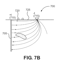
100531 Figures 7A and 7B illustrate a system 700 for determining a
leakage current
distribution along at least a portion of a long conductor extending into the
earth. Part of system
700, which includes a simple non-conductive structure supporting the spaced
apart sensors with
associated voltage amplifiers, power supply and an amplifier for sending the
resulting voltage
differences to the surface, is called an electric field measuring tool 701.
Specifically, Figure 7A
shows an electric field measuring tool 701 in a long conductor 705. A source
710 is electrically
or inductively connected to long conductor 705 and is configured to transmit
current along long
conductor 705 so that current leaks from along long conductor 705 forming a
leakage current
distribution 712 represented by a series of arrows with the length of each
arrow representing the
amount of current at that arrow. A receiver 715 measures an electromagnetic
field generated by
the current transmitted from source 710. In Figure 7B sensors 720, are placed
on or near the
ground surface 725. A schematic rendering of tool 701 is shown in Figure 8A.
Tool 701
includes two sensors 800 and 801 and a control (or computer) system 805
configured to
determine the leakage current distribution along the long conductor from a
series of
14
CA 03034906 2019-02-22
WO 2018/045331 PCT/US2017/049936
measurements. Computer system 805 is further configured to determine a source
current
distribution from leakage current distribution 712 in connection with a
geophysical survey. For
instance, computer system 805 can be configured to create a survey map from
the source current
distribution and a resistivity distribution within a subsurface volume with
the leakage current
distribution. Some of the sensors 720, 800, and 801 are magnetic field sensors
or capacitive
sensors. The sensor may be placed in, on or adjacent to long conductor 705 as
shown in Figure
7A or may be placed on or near the ground surface as shown in Figure 7B.
Sensors 720 are
analogous to sensors 800 and 801 and are connected to a computer system (not
shown)
analogous to system 805, which works in the same manner. Source 710 is
preferably a current
source or a magnetic source and may be fon-ned as a loop of wire. Natural
sources may also be
employed.
100541 A demonstrated capacitive marine system had a sensor separation of
one meter,
and the noise level was observed to be approximately 1.0 nanovolthiHz at 1.0
Hz. This system is
described in U.S. Patent Application Publication No. 2008/0246485, which is
incorporated
herein by reference. The corresponding noise level in V/m for a sensor spacing
of 5.0 meters,
which might be typical for the borehole tool, would be 0.2 nV/mNHz. From a
practical point of
view, such an electric field tool should accurately measure the change in
electric field E passing
through a layer. For example, from Figures 5 and 6, it would be desirable to
accurately measure
a change in field of 12 x 10-7 V/m across a conductive layer and 5.5 x 10⁻⁷
V/m across a resistive
layer. The actual voltage difference for a 5.0-meter spacing would be five
times that, and if
1.0 A of current were injected the electric field estimates are 6.0 x 10⁻⁶ V/m
and 2.95 x 10⁻⁶ V/m,
respectively. Given an expected noise level of 0.2 nV/m/AiHz, the signal-to-
noise for these
examples would be 3 x 10⁴ and approximately 1.5 x 10⁴, respectively. There may
be
unanticipated noise in the borehole so these signal-to-noise ratios could
easily be increased by a
factor of ten by using 10 Amperes of injected current. For this example,
source function electric
dipoles, Id!, are 5.0 meters long, and the current in each is calculated using
the casing current
expression shown above in Equation (1).
100551 Usually, the dimensions and resistivity of the long conductor are
accurately
known and are constant along its length. However, there are situations where
the conductor may
have corroded, resulting in a change of wall thickness or even diameter, or
the conductor may
have been damaged. For these situations, the long conductor's resistance
should be measured
CA 03034906 2019-02-22
WO 2018/045331
PCT/US2017/049936
experimentally by the tool. This can be done by adding a power supply and two
current
electrodes to the tool, as shown schematically in Figure 8B where the current
electrodes are
labeled 810 and 811. In this mode of operation, the tool is converted to a two
electrode¨two
sensor system for measuring the long conductor's resistance. In this example,
two current
electrodes 810, 811 are introduced in the middle one third of the overall
electrode length L.
Following the nomenclature of Figure 8B and noting the use of lowercase v for
voltage in the
casing resistivity system, the voltage difference, Av = v2 - vi, can be found
via:
+ I peL13
vi from +I current electrode, -1)1 =
gd,t,
_ ¨I p, 2L/ 3
vi from 4 current electrode, vi =
gdete
+ I p, 2L/3
1,2 from +1 current electrode, v2 =
rtdt
- ¨1P, ,
L13
V2 from -I current electrode, v2 =
gd,t,
Then:
I peL13 (2 1+1+2)= 4 II pcL
Av = v2¨ v1= (2)
7z-dcte 3 rrd,t,
From Equation (2):
p,L 3 Av
(3)
itdct, 4 I
Substituting this equation in Equation (1) yields an expression for /c:
AV
/ =
4 V
(4)
PcL = 3 I AAv
Ird t
c c
100561
Equation (4) yields the required current flowing in or on the long conductor
in
terms of the measured change in voltage caused by the injected current and the
measurements of
voltage and current in the two electrode¨two sensor mode of operation.
100571
Equation (3) can be used to calculate the voltage v expected for a given
current
via:
16
CA 03034906 2019-02-22
WO 2018/045331
PCT/US2017/049936
Av )9,1 4
I 7-t-cl et 3
100581 Assuming a typical long conductor resistivity of 5.4 x 10⁶ Ohm
meters, a diameter
of 10 inches (0.254 m) and a wall thickness of 0.5 inch (0.0127 m),
Ay
¨ = 1 .2x1 0-4 volts/ampere
100591 Given the sensitivities noted above for the capacitive sensors, a
current of only
10-3 A would provide more than enough voltage for the two electrode¨two sensor
measurement.
100601 In practice, the measurements would typically be made sequentially
first, the
voltage drop with the applied current in the long conductor and then, with
that current turned off,
the two electrode¨two sensor resistivity mode is turned on. Both operations
are controlled and
voltage measurements made by control system 805 (shown in Figures 8A and 8B).
All voltage
and current values can be sent to the surface by way of the cable used to
lower the tool in the
well.
100611 The most accurate measurements will be made with tool 701 stopped
at regular
intervals, for example, at separations of one tool length. More averaged
estimates of casing
current can be obtained by moving tool 701 continuously in the well, although
it is anticipated
that the tool will generate a certain amount of motion induced noise.
100621 The tool and method described above are only one potential system
for measuring
the electrical current using sensors inside a long conductor. There exist
alternative methods to
measure potential differences inside a long conductor, such as connecting a
source current to the
conductor at the ground surface and lowering sensors down the conductor or
attaching electric
field sensors to a moveable electrode and measuring potential differences
while transmitting
current from the surface down the wire and into the long conductor at depth.
In general, the
present invention is directed to any method of placing sensors in a borehole
with the intention of
measuring a casing current for interpreting borehole-to-surface
electromagnetic data.
100631 The method described above also focuses on the measurement of the
electric field
along the axis of the long conductor, but alternatively the same method can be
applied using
sensors that are sensitive to the magnetic field inside a long conductor.
Further to this, the
source discussed above is an electrical current source. Alternatively, one
could use a magnetic
field source either at or near the surface or within the Long conductor
itself. This includes the
17
CA 03034906 2019-02-22
WO 2018/045331 PCT/US2017/049936
use of a loop of wire as a source or any other inductively coupled methods of
causing current to
flow in or on the long conductor, including natural fields.
Measurements at the Surface
100641 Measurements of the electric and/or magnetic field made at or near
the surface
while current is being passed into a nearby long conductor can be made such
that they are
sensitive to variations in the flow of current in or on the conductor.
Measurements made very
close to the wellhead (where the long conductor is near the ground surface)
will be most
sensitive to the current flowing in or on the conductor close to the surface,
and further away the
measurements become more sensitive to deeper current flow. Preferably the
sensors extend in
one or two directions along a one dimensional line to a distance approximately
equal to the depth
of the well or length of the conductor.
100651 The data measured at multiple locations with varying radial
distances from the
wellhead can be used to determine if a particular model response matches or
not, and in that way
the surface data can be used to determine an accurate model of current flow on
the casing.
100661 There are a number of methods that can be used to derive an
acceptable model of
current flow from the data in this way. This can include the use of any form
of calculating,
modeling or other forms of determination used to derive the leakage current
distribution from the
sensed measurements. The term "modeling" includes, by way of examples,
geophysical
inversion methods, forward modelling procedures, or any form of modelling.
100671 As in the previous method described, the source used here can be
any method to
cause currents to flow in or on the long conductor, including but not limited
to an electrical
current source, a magnetic field source, a loop of wire source, or any other
inductively coupled
methods that drives an electrical current in or on the long conductor.
100681 Based on the above, it should be readily apparent that the present
invention
provides systems and methods for obtaining an accurate measurement or estimate
of the flow of
current along a long conductor and, by doing so, allows an estimation of the
current leaking out
of the long conductor. While certain preferred embodiments of the present
invention have been
set forth, it should be understood that various changes or modifications could
be made without
departing from the spirit of the present invention. In general, the invention
is only intended to be
limited by the scope of the following claims.
18