Note: Descriptions are shown in the official language in which they were submitted.
WO 2018/085107
PCTIUS2017/058477
GAP MEASUREMENT FOR VEHICLE CONVOYING
100011
BACKGROUND
100021 The present invention relates generally to systems and
methods for
enabling vehicles to closely follow one another safely using automatic or
partially
automatic control.
[0003] In recent years significant strides have been made in the
fields of
autonomous and semi-autonomous vehicles. One segment of vehicle automation
relates
to vehicular convoying systems that enable vehicles to follow closely together
in a safe,
efficient and convenient manner. Following closely behind another vehicle
has significant fuel savings benefits, but is generally unsafe when done
manually by the
driver. One type of vehicle convoying system is sometimes referred to as
vehicle
platooning systems in which a second, and potentially additional, vehicle(s)
is/are
autonomously or semi-autonomously controlled to closely follow a lead vehicle
in a safe
manner.
[0004] In vehicle platooning and convoying systems an understanding of the
distance between the vehicles is a very important control parameter and
multiple
different independent mechanisms may be used to determine the distance between
vehicles. These may include radar systems, transmitting absolute or relative
position
data between vehicles (e.g., GPS or other GNSS data), LIDAR systems, cameras,
etc.
A challenge that occurs when using radar in platooning type applications is
that the partner
vehicle must be reliably identified from a potentially ambiguous set of radar
reflections
and tracked under constantly changing conditions. The present application
describes
techniques for identifying and tracking specific vehicles based on vehicle
radar data that
are well suited for platooning, convoying and other autonomous or semi-
autonomous
driving applications.
1
CA 3042647 2019-08-29
CA 03042647 2019-05-02
WO 2018/085107
PCT/US2017/058477
SUMMARY
[0005] A variety of
methods, controllers and algorithms are described for
identifying the back of a particular vehicle (e.g., a platoon partner) in a
set of distance
measurement scenes and/or for tracking the back of such a vehicle. The
described
techniques can be used in conjunction with a variety of different distance
measuring
technologies including radar, LIDAR, sonar units or any other time-of-flight
distance
measuring sensors, camera based distance measuring units, and others.
[0006] In one
aspect, a radar (or other distance measurement) scene is received
and first vehicle point candidates are identified at least in part by
comparing the
relative position of the respective detected objects that they represent, and
in some
circumstances the relative velocity of such detected objects, to an estimated
position
(and relative velocity) for the first vehicle. The first vehicle point
candidates are
categorized based on their respective distances of the detected objects that
they
represent from the estimated position of the first vehicle. The categorization
is
repeated for a multiplicity of samples so that the categorized first vehicle
point
candidates include candidates from multiple sequential samples. The back of
the first
vehicle is then identified based at least in part of the categorization of the
first vehicle
point candidates. The identified back of the first vehicle or an effective
vehicle length
that is determined based at least in part on the identified back of the first
vehicle may
then be used in the control of the second vehicle.
[0007] In some
embodiments, a bounding box is conceptually applied around the
estimated position of the first vehicle and measurement system object points
that are
not located within the bounding box are not considered first vehicle point
candidates.
In some embodiments, the bounding box defines a region that exceeds a maximum
expected size of the first vehicle.
[0008] In some
embodiments, the relative velocity of the vehicles is estimated
together with an associated speed uncertainty. In such embodiments, object
points
within the set of detected object points that are moving at a relative speed
that is not
within the speed uncertainty of the estimated speed are not considered first
vehicle
point candidates.
[0009] In some
embodiments, categorizing the first vehicle point candidates
includes populating a histogram with the first vehicle point candidates. The
2
CA 03042647 2019-05-02
WO 2018/085107
PCT/US2017/058477
histogram including a plurality of bins, with each bin representing a
longitudinal
distance range relative to the estimated position of the first vehicle. In
such
embodiments, the identification of the back of the first vehicle may be done
after the
histogram contains at least a predetermined number of first vehicle point
candidates.
In some embodiments, a clustering algorithm (as for example a modified mean
shift
algorithm) is applied to the first vehicle point candidates to identify one or
more
clusters of first vehicle point candidates. In such embodiments, the cluster
located
closest to the second vehicle that includes at least a predetermined threshold
percentage or number of first vehicle radar point candidates may be selected
to
represent the back of the first vehicle.
[0010] In some
embodiments, Kalman filtering is used to estimate the position of
the first vehicle.
[0011] In another
aspect, methods of tracking a specific lead vehicle using a
distance measuring unit mounted on a trailing vehicle are described. In this
embodiment, a current radar (or other distance measurement) sample is obtained
from
a radar (or other distance measurement) unit. The current distance measurement
sample includes a set of zero or more object points. In parallel, a current
estimate of a
state of the lead vehicle corresponding to the current sample is obtained. The
current
state estimate includes one or more state parameters which may include (but is
not
limited to), a position parameter (such as the current relative position of
the lead
vehicle), a speed parameter (such as a current relative velocity of the lead
vehicle)
and/or other position and/or orientation related parameters.
[0012] The current
estimate of the state of the lead vehicle has an associated state
uncertainty and does not take into account any information from the current
distance
measurement sample. A determination is made regarding whether any of the
object
points match the estimated state of the lead vehicle within the state
uncertainty. If so,
the matching object point that best matches the estimated state of the lead
vehicle is
selected as a measured state of the lead vehicle. That measured state of the
lead
vehicle is then used in the determination of a sequentially next estimate of
the state of
the lead vehicle corresponding to a sequentially next sample. The foregoing
steps are
repeated a multiplicities of times to thereby track the lead vehicle. The
measured
states of the lead vehicle may be used in the control of one or both of the
vehicles ¨ as
3
CA 03042647 2019-05-02
WO 2018/085107
PCT/US2017/058477
for example in the context of vehicle platooning or convoying systems, in the
at least
partially automatic control of the trailing vehicle to maintain a desired gap
between
the lead vehicle and the trailing vehicle.
[0013] In some
embodiments, each sample indicates, for each of the object points,
a position of a detected object corresponding to such object point (relative
to the
distance measuring unit). Each current estimate of the state of the lead
vehicle
includes a current estimate of the (relative) position of the lead vehicle and
has an
associated position uncertainty. To be considered a valid measurement, the
selected
matching object point must match the estimated position of the lead vehicle
within the
position uncertainty. In some implementations, the current estimate of the
position of
the lead vehicle estimates the current position of a back of the lead vehicle.
[0014] In some
implementations, each sample indicates, for each of the object
points, a relative velocity of a detected object corresponding to such object
point
(relative to the distance measuring unit). Each current estimate of the state
of the lead
vehicle includes a current estimate of the relative velocity of the lead
vehicle and has
an associated velocity uncertainty. To be considered a valid measurement, the
selected matching object point must match the estimated relative velocity of
the lead
vehicle within the velocity uncertainty.
[0015] In some
embodiments, when none of the radar object points in a particular
distance measurement sample match the estimated state of the lead vehicle
within the
state uncertainty, then the state uncertainty is increased for the
sequentially next
estimate of the state of the lead vehicle.
[0016] In some
embodiments, global navigation satellite systems (GNSS) position
updates are periodically received based at least in part on detected GNSS
positions of
the lead and trailing vehicles. Each time a vehicle GNSS position update is
received,
the estimated state of the lead vehicle and the state uncertainty are updated
based on
such position update.
[0017] In some
embodiments vehicle speed updates are periodically received
based at least in part on detected wheel speeds of the lead and trailing
vehicles. Each
time a vehicle speed update is received, the estimated state of the lead
vehicle and the
state uncertainty are updated based on such lead vehicle speed update.
4
CA 03042647 2019-05-02
WO 2018/085107
PCT/1JS2017/058477
[0018] In another
aspect, a variety of methods, controllers and algorithms are
described for fusing sensor data obtained from different vehicles for use in
the at least
partial automatic control of a particular vehicle. The described techniques
are well
suited for use in conjunction with a variety of different vehicle control
applications
including platooning, convoying and other connected driving applications.
[0019] In one
aspect, information about a second vehicle is sensed at a first
vehicle using a first sensor on the first vehicle while the first and second
vehicles are
driving. Information about the second vehicle is also received by the first
vehicle
from the second vehicle. The received second vehicle information is utilized
to help
determine whether the sensed information about the second vehicle is a valid
measurement of the second vehicle. The first vehicle is then at least
partially
automatically controlled based at least in part on an aspect of the sensed
information
about the second vehicle.
[0020] In some
embodiments, the first sensor measures a distance to the second
vehicle. In some implementations, the first sensor also detects a velocity of
the
second vehicle relative to the first vehicle. In different embodiments, the
first sensor
may be any of a radar unit, a LIDAR unit, a sonar unit, a time-of-flight
distance
sensor, a sensor configured to receive a signal transmitted from a beacon on
the
second vehicle, a camera, and a stereo camera unit.
[0021] In some embodiments the received second vehicle information includes
one or more of: a global navigation satellite systems (GNSS) position
measurement of
a current position of the second vehicle; speed information indicative of a
speed or
relative speed of the second vehicle (as for example wheel speed); and an
indication
of at least one of an acceleration, an orientation, a steering angle, a yaw
rate, a tilt, an
incline or a lateral motion of the second vehicle.
[0022] In some
embodiments the received second vehicle information includes a
predicted state of the second vehicle. The predicted state may optionally
include one
or more of a predicted position, a predicted speed, a predicted acceleration,
a
predicted orientation, a predicted yaw rate, a predicted tilt, a predicted
incline and a
predicted lateral motion of the second vehicle.
5
CA 03042647 2019-05-02
WO 2018/085107
PCT/1JS2017/058477
[0023] The
described approaches are well suited for use in vehicle platooning
and/or vehicle convoying systems including tractor-trailer truck platooning
applications.
BRIEF DESCRIPTION OF THE DRAWINGS
[0024] The invention and the advantages thereof, may best be understood by
reference to the following description taken in conjunction with the
accompanying
drawings in which:
[0025] FIG. 1 is a
block diagram of a representative platooning control
architecture.
[0026] FIG. 2 is a flow chart illustrating a method of determining the
effective
length of a platoon partner based on outputs of a radar unit.
[0027] FIG. 3 is a
diagrammatic illustration showing the nature of a bounding box
relative to a partner vehicle's expected position.
[0028] FIG. 4A is a
diagrammatic illustration showing exemplary radar object
points that might be identified by a radar unit associated with a trailing
truck that is
following directly behind a lead truck.
[0029] FIG. 4B is a
diagrammatic illustration showing a circumstance where the
entire lead truck of FIG 4A is not within the radar unit's field of view.
[0030] FIG. 4C is a
diagrammatic illustration showing a circumstance where the
bounding box associated with the lead truck of FIG 4A is not entirely within
the radar
unit's field of view.
[0031] FIG. 4D is a
diagrammatic illustration showing a circumstance where the
lead truck is in a different lane than the trailing truck, but its entire
bounding box is
within the radar unit's field of view.
[0032] FIG. 5A is a graph that illustrates the relative location
(longitudinally and
laterally) of a first representative set of partner vehicle radar point
candidates that
might be detected when following a tractor-trailer rig.
[0033] FIG. 5B is a
histogram representing the longitudinal distances of the
detected partner vehicle radar point candidates illustrated in Fig. 5A.
[0034] FIG. 5C is a plot showing the mean shift centers of the histogram
points
represented in Fig. 5B.
6
WO 2018/085107
PCT/US2017/058477
[0035] FIG. 5D is a graph that illustrates the relative location
(longitudinally and
laterally) of a second (enlarged) set of partner vehicle radar point
candidates that might be
detected when following a tractor-trailer rig.
100361 FIG. 5E is a histogram representing the longitudinal
distances of the
detected partner vehicle radar point candidates illustrated in Fig. 5D.
100371 FIG. 5F is a plot showing the mean shift centers of the
histogram points
represented in Fig. 5E.
100381 FIG. 6 is a diagrammatic block diagram of a radar scene
processor suitable
for use by a vehicle controller to interpret received radar scenes.
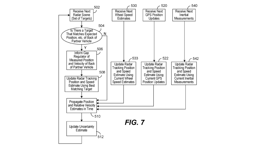
100391 FIG. 7 is a flow chart illustrating a method of determining whether
any
particular radar scene reports the position of the back of a partner vehicle
and updating
the estimator of Fig. 6.
[00401 FIG. 8 is a representation of a Kalman filter state array
and covariance
matrix suitable for use in some embodiments.
[0041] In the drawings, like reference numerals are sometimes used to
designate
like structural elements. It should also be appreciated that the depictions in
the figures
are diagrammatic and not to scale.
DETAILED DESCRIPTION OF THE PREFERRED EMBODIMENTS
100421 The Applicant has proposed various vehicle platooning
systems in which a
second, and potentially additional, vehicle(s) is/are autonomously or semi-
autonomously controlled to closely follow a lead vehicle in a safe manner. By
way
of example, U.S. Application Nos. 13/542,622, 13/542,627 and 14/292.583; U.S.
Provisional Application Nos. 61/505,076, 62/249,898, 62/343,819, 62/377,970
and;
and PCT Application Nos. PCT/US2014/030770, PCT/US2016/049143 and
PCT/US2016/060167 describe various vehicle platooning systems in which a
trailing
vehicle is at least partially automatically controlled to closely follow a
designated lead
vehicle.
100431 One of the goals of platooning is typically to maintain a
desired
longitudinal distance between the platooning vehicles, which is frequently
referred to
herein as the "desired gap". That is, it is desirable for the trailing vehicle
(e.g., a
trailing truck) to maintain a designated gap relative to a specific vehicle
(e.g., a lead truck).
The vehicles involved in a platoon will typically have sophisticated control
7
CA 3042647 2019-08-29
CA 03042647 2019-05-02
WO 2018/085107
PCT/US2017/058477
systems suitable for initiating a platoon, maintaining the gap under a wide
variety of
different driving conditions, and gracefully dissolving the platoon as
appropriate.
[0044] The
architecture and design of control systems suitable for implementing
vehicle platooning may vary widely. By way of example, Figure 1
diagrammatically
illustrates a vehicle control architecture that is suitable for use with
platooning tractor-
trailer trucks. In the illustrated embodiment a platoon controller 110,
receives inputs
from a number of sensors 130 on the tractor and/or one or more trailers or
other
connected units, and a number of actuators and actuator controllers 150
arranged to
control operation of the tractor's powertrain and other vehicle systems. An
actuator
interface (not shown) may be provided to facilitate communications between the
platoon controller 110 and the actuator controllers 150. The platoon
controller 110
also interacts with an inter-vehicle communications controller 170 which
orchestrates
communications with the platoon partner and a NOC communications controller
180
that orchestrates communications with a network operations center (NOC). The
vehicle also preferably has selected configuration files that include known
information about the vehicle.
[0045] Some of the
functional components of the platoon controller 110 include
gap regulator 112, mass estimator 114, radar tracker 116 and brake health
monitor
118. In many applications, the platoon controller 110 will include a variety
of other
components as well.
[0046] Some of the
sensors utilized by the platoon controller 110 may include
GNSS (GPS) unit 131, wheel speed sensors 132, inertial measurement devices
134,
radar unit 137, LIDAR unit 138, cameras 139, accelerator pedal position sensor
141,
steering wheel position sensor 142, brake pedal position sensor 143, and
various
accelerometers. Of course, not all of these sensors will be available on all
vehicles
involved in a platoon and not all of these sensors are required in any
particular
embodiment. A variety of other sensor (now existing or later developed or
commercially deployed) may be additionally or alternatively he utilized by the
platoon controller in other embodiments. In the primary embodiments described
herein, GPS position data is used. However, GPS is just one of the currently
available
global navigation satellite systems (GNSS). Therefore, it should be
appreciated that
8
CA 03042647 2019-05-02
WO 2018/085107
PCT/US2017/058477
data from any other GNSS system or from other suitable position sensing
systems
may be used in place of, or in addition to the GPS system.
[0047] Many (but
not all) of the described sensors, including wheel speed sensors,
132, radar unit 137, accelerator pedal position sensor 141, steering wheel
position
.. sensor 142, brake pedal position sensor 143, and accelerometer 144 are
relatively
standard equipment on newer trucks (tractors) used to pull semi-trailers.
However,
others, such as the GNSS unit 131 and LIDAR unit 138 (if used) are not
currently
standard equipment on such tractors or may not be present on a particular
vehicle and
may be installed as needed or desired to help support platooning.
[0048] Some of the vehicle actuators controllers 150 that the platoon
controller
directs at least in part include torque request controller 152 (which may be
integrated
in an ECU or power train controller); transmission controller 154, brake
controller
156 and clutch controller 158.
[0049] The
communications between vehicles may be directed over any suitable
.. channel and may be coordinated by inter-vehicle communications controller
170. By
way of example, the Dedicated Short Range Communications (DSRC) protocol (e.g.
the IEEE 802.11p protocol), which is a two-way short to medium range wireless
communications technology that has been developed for vehicle to vehicle
communications, works well. Of course other communications protocols and
channels may be used in addition to or in place of a DSRC link. For example,
the
inter vehicle communications may additionally or alternatively be transmitted
over a
Citizen's Band (CB) Radio channel, one or more General Mobile Radio Service
(GMRS) bands, and one or more Family Radio Service (FRS) bands or any other
now
existing or later developed communications channels using any suitable
communication protocol.
[0050] The specific
information transmitted back and forth between the vehicles
may vary widely based on the needs of the platoon controller. In various
embodiments, the transmitted information may include the current commands
generated by the platoon controller such as requested/commanded engine torque,
requested/commanded braking deceleration. They may also include steering
commands, gear commands, etc. when those aspects are controlled by platoon
controller. Corresponding information is received from the partner vehicle,
regardless
9
CA 03042647 2019-05-02
WO 2018/085107
PCT/US2017/058477
of whether those commands are generated by a platoon controller or other
autonomous or semi-autonomous controller on the partner vehicle (e.g., an
adaptive
cruise control system (ACC) or a collision mitigation system (CMS)), or
through
other or more traditional mechanisms ¨ as for example, in response to driver
inputs
(e.g., accelerator pedal position, brake position, steering wheel position,
etc.).
[0051] In many
embodiments, much or all of the tractor sensor information
provided to platoon controller is also transmitted to the platoon partner and
corresponding information is received from the platoon partner so that the
platoon
controllers on each vehicle can develop an accurate model of what the partner
vehicle
is doing. The same is true for any other relevant information that is provided
to the
platoon controller, including any vehicle configuration information that is
relevant to
the platoon controller. It should be appreciated that the specific information
transmitted may vary widely based on the requirements of the platoon
controllers, the
sensors and actuators available on the respective vehicles, and the specific
knowledge
that each vehicle may have about itself.
[0052] The
information transmitted between vehicles may also include
information about intended future actions. For example, if the lead vehicle
knows it
approaching a hill, it may expect to increase its torque request (or decrease
its torque
request in the context of a downhill) in the near future and that information
can be
conveyed to a trailing vehicle for use as appropriate by the platoon
controller. Of
course, there is a wide variety of other information that can be used to
foresee future
torque or braking requests and that information can be conveyed in a variety
of
different forms. In some embodiments, the nature of the expected events
themselves
can be indicated (e.g., a hill, or curve or exit is approaching) together with
the
expected timing of such events. In other embodiments, the intended future
actions
can be reported in the context of expected control commands such as the
expected
torques and/or other control parameters and the timing at which such changes
are
expected. Of course, there are a wide variety of different types of expected
events
that may be relevant to the platoon control.
[0053] The
communications between the vehicles and the NOC may be
transmitted over a variety of different networks, such as the cellular
network, various
Wi-Fi networks, satellite communications networks and/or any of a variety of
other
CA 03042647 2019-05-02
WO 2018/085107
PCT/US2017/058477
networks as appropriate. The communications with the NOC may be coordinated by
NOC communications controller 180. The information transmitted to and/or
received
from the NOC may vary widely based on the overall system design. In some
circumstances, the NOC may provide specific control parameters such as a
target gap
tolerance. These control parameters or constraints may be based on factors
known at
the NOC such as speed limits, the nature of the road/terrain (e.g., hilly vs.
flat,
winding vs. straight, etc.) weather conditions, traffic or road conditions,
etc. In other
circumstances the NOC may provide information such information to the platoon
controller. The NOC may also provide information about the partner vehicle
including its configuration information and any known relevant information
about its
current operational state such as weight, trailer length, etc.
Radar Tracking
[0054] The vehicles
involved in a platoon will typically have one or more radar
systems that are used to detect nearby objects. Since radar systems tend to be
quite
good at determining distances between objects, separation distances reported
by the
radar unit(s) are quite useful in controlling the gap between vehicles.
Therefore, once
a platooning partner is identified, it is important to locate that specific
partner vehicle
in the context of the radar system output. That is, to determine which (if
any) of a
variety of different objects that might be identified by the radar unit
correspond to the
targeted partner.
[0055]
Preliminarily, it should be appreciated that the platoon partner will not
always correlate to the closest vehicle detected by the radar unit or to the
vehicle that
is directly in front of the trailing truck. There are a wide variety of
different scenarios
that can cause this to be the case. For example, when the platoon is initially
being set
up, the partner may be out of sight of a host vehicle's radar unit because it
is too far
away. As the partner comes into sight of the radar unit, it becomes important
to
identify and distinguish that partner from other objects in the radar unit's
field of
view. The description below describes techniques that are particularly well
suited for
identifying and distinguishing a designated partner from other objects that
may be
detected by a radar unit so that the radar unit can effectively track the
partner vehicle
(sometimes referred to as "locking onto" the partner).
11
CA 03042647 2019-05-02
WO 2018/085107
PCT/US2017/058477
[0056] Furthermore,
during the course of driving, there will be traffic in adjacent
lanes that are traveling beside, passing or being passed by the platoon and it
is
important for the radar unit to be able to continue to differentiate the
platoon partner
from passing vehicles so that the gap controller doesn't start trying to
maintain the
gap from the wrong vehicle. In another example, a lead truck may change lanes
at
which point it may not be directly in front of the trailing vehicle, so again,
it is
important for that the distance between the platoon partners reported by the
radar unit
be associated with the platoon partner rather than merely the closest vehicle
or a
vehicle that happens to be directly in front of the trailing truck. There may
also be
times when the radar unit may not be able to "see" the platooning partner.
This could
be because an interloper has gotten between the platoon partners or the lead
vehicle
has maneuvered out of view of the trailing vehicle's radar unit, interference
with the
radar signals, etc.
[0057] For platoon
control purposes, it is also important to understand where the
back of the vehicle is relative to the vehicle's reported position. To
elaborate, the
position of the partner vehicle is generally known from the GPS based location
information that is transmitted to the host vehicle. However, the GPS system
typically reports a location on the tractor, which could for example, be the
position of
the antenna(s) that receive the GPS signals. The detected GPS position may
then be
translated to the position of a reference location on the vehicle that is a
known
distance from the GPS antenna, with the position of that reference location
serving as
the vehicle's reported GPS position. The specific reference location chosen
may vary
based on control system preferences. By way of example, in some tractor
trailer truck
platooning embodiments, the reference location may be the center of the rear
axles of
the tractor.
[0058] The
difference between the reported GPS position and the physical back of
the vehicle can be significant to the platoon control. Therefore, it is often
important
to know the distance between the reported vehicle position and the actual back
of the
vehicle. This is sometimes referred to herein as the "effective vehicle
length." The
effective vehicle length is particularly important in the context of a tractor
trailer truck
where the reported GPS position is typically located somewhere on the cab
(tractor)
and the distance from the reported GPS position to the back of the trailer may
be quite
12
CA 03042647 2019-05-02
WO 2018/085107
PCT/US2017/058477
long. By way of example, trailer lengths on the order of 12-18 meters are
common in
the U.S. although they can be shorter or longer (indeed much longer in the
context of
double or triple trailers). The distance from the reported GPS position to the
back of
the vehicle must also account for the longitudinal distance from the reported
GPS
position to the front of the trailer and/or any extensions associate with the
load. It
should be appreciated that in the trucking industry, the effective vehicle
length often
will not be known since any particular tractor may pull a variety of different
trailers
and the attachment point between the tractor and trailer is adjustable on the
tractor.
Establishing a Radar Fix on a Platoon Partner
[0059] As will be apparent from the discussion above, a challenge that
occurs
when using radar in platooning type applications is that the partner vehicle
must
initially be found and identified in the context of the radar system's output
and
thereafter reliably tracked under constantly changing conditions. In
application such
as the trucking industry, it is also desirable to determine the effective
length of at least
the lead vehicle.
[0060] Commercially
available radar units used in general road vehicle driving
automation systems typically output data that indicates the presence of any
object(s)
detected within a designated field together with the relative position and
speed of such
object(s). Thus, during driving, such a radar unit may detect the presence of
a variety
.. of objects within its operational field. The detected objects may include
any vehicle
positioned directly in front of the host vehicle, vehicles in adjacent lanes
that may be
passing, being passed by or driving in parallel to the platoon, stationary
objects such
as obstacles in the road, signs, trees, and other objects to the side of the
road, etc.
Although many different types of objects may be detected, the radar unit
itself
.. typically doesn't know or convey the identity or nature of the detected
object. Rather
it simply reports the relative position and motion of any and all perceived
objects
within its operational field. Therefore, to identify and track the partner
vehicle in the
context of the radar unit output, it is helpful for the logic interpreting the
output of the
radar unit to have and maintain a good understanding of exactly where the
partner
vehicle is expected to be relative to the radar unit's field of view
regardless of
whether the partner vehicle is even in that field of view. This is possible
even when
no explicit mechanism is provided for identifying the partner because the
platooning
13
WO 2018/085107
PCT1US2017/058477
system preferably has multiple independent mechanisms that can be used to help
determine a vehicle's position.
[00611 When a platoon partner is identified a communications link is
preferably
established between the platooning vehicles. The communications may be
established
over one or more wireless links such as a Dedicated Short Range Communications
(DSRC) link, a cellular link, etc. Once communications are established between
the two
vehicles, they begin transmitting data back and forth regarding their
respective selves,
their current locations and operational states. The processes used to identify
potential
platoon partners and to establish the platoon and appropriate communication
links may vary widely. By way of example, a few representative techniques are
described in U.S. Patent Application Nos. 13/542,622 and 13/542,627 as well as
PCT
Patent Application Nos. PCT/US2014/030770, PCT/US2016/049143 and
PCT/US2016/060167 previously filed by Applicant.
100621 Once a platoon partner has been identified, the platoon controller
110
requests the radar system control logic attempt to find the partner vehicle.
More
specifically, the trailing vehicle's radar tracker 116 needs to find and
thereafter track the
back of the lead vehicle in the context of the radar unit's outputs so that
its data can be
used in gap control. Referring next to Fig. 2, a method particularly well
suited
for establishing a radar fix on a platoon partner will be described. One
aspect of
establishing a radar fix is to determine the length of the partner so the GPS
position
information can be correlated to radar system outputs.
100631 When the process initiates, radar tracker control logic
determines, receives
or requests an estimate of the current relative position of the partner
vehicle and
subscribes to or regularly receives updates regarding the partner vehicle's
relative
position as they become available as represented by step 203 of Fig. 2. In
addition to the
relative locations, the estimated information may optionally include various
additional
position related information such as relative velocity of the vehicles, the
relative heading
of the vehicles, etc.
[0064] In some embodiments, the radar tracker control logic is configured
to
estimate the current relative position, velocity and orientation (heading) of
the partner
vehicle based on a variety of sensor inputs from both the host vehicle and the
partner
14
CA 3042647 2019-08-29
CA 03042647 2019-05-02
WO 2018/085107
PCT/US2017/058477
vehicle. As mentioned above, the platoon partners are in communication with
one
another and during platooning, they send extensive information back and forth
about
themselves, including continually updated information about their current
location
and operating states. By way of example, some of the location related
information
that can be helpful to interpreting radar unit data may include information
such as the
partner vehicle's UPS position, wheel speed, orientation/heading (direction
that the
vehicle is heading), yaw rate (which indicates the vehicle's rate of turn),
pitch, roll
and acceleration/deceleration (longitudinal and angular in any of the forgoing
directions). Operational related information may also include a variety of
other
information of interest such the current torque requests, brake inputs, gear,
etc.
Information about the vehicles, may include information such as the make and
model
of the vehicle, its length (if known), its equipment, estimated weight, etc.
Any of
these and/or other available information can be used in the position related
estimates.
By way of example, one particular position estimator is described below with
respect
to Figs. 6 and 7.
[0065] Although a
particular estimator is described, it should be appreciated that
the estimated partner vehicle position related information can come from any
appropriate source and the estimation does not need to be made by the radar
tracker
control logic itself. Additionally, although it is preferred that position and
operational
information be transmitted in both directions between vehicles, that is not
necessary
as long as the host vehicle is able to obtain the required information about
the partner
vehicle(s).
[0066] The current
location related information is updated very frequently.
Although the actual frequency of the updates can vary widely based on the
nature of
the information being updated and the nature of the communication link or
vehicle
system that provides the information, update frequencies for items such as GPS
position and wheel speed received over a DSRC link at frequencies on the order
of 10
to 500 Hz, as for example 50 Hz work well although slower and much faster
update
frequencies may be used as appropriate in other embodiments. Furthermore,
although
regular updates of the location related information are desirable, there is no
need that
they be received synchronously or at consistent intervals.
CA 03042647 2019-05-02
WO 2018/085107
PCT/US2017/058477
[0067] It should be
appreciated that when the radar system begins trying to locate
the partner vehicle, the partner vehicles may or may not be within the radar
unit's
field of view. However both the host vehicle's position and the partner
vehicle's
position are generally known based at least on the received GPS data so it is
easy to
estimate their separation with reasonable certainty. It should also be
appreciated that
although GPS location signals tend to be pretty good, the reported locations
may be
off by some amount and thus it is better to treat any reported GPS position as
an
estimate with some appropriate amount of uncertainty rather than treating the
reported
position as infallible information. More details regarding some specific
algorithms
that are suitable for estimating the partner vehicle position will be
described in more
detail below. Experience has shown that GPS position readings from
commercially
available GPS sensors used in vehicle automation applications tend to be
accurate
within about 2-3 meters in practical road conditions when there is a direct
line of sight
to at least 4 GPS satellites. However, it should be appreciated that some GPS
sensors
are regularly more precise and no GPS sensors are guaranteed to always be that
accurate due to variables such as interference, operations is regions where
there is not
line of sight visibility to the required number of operational GPS satellites,
etc.
[0068] Once the
partner vehicle's relative position estimate is known, a bounding
box is applied around the estimated relative position of the partner (step 206
of Fig.
2). The purpose of the bounding box is to define a region that the partner
vehicle is
"expected". to be found in. The logic will thereafter look for radar detected
objects
located within that bounding box in an effort to identify objects that may
correlate to
the partner vehicle. The concept of a bounding box is helpful for several
reasons.
Initially it should be appreciated that the GPS unit will typically report the
location of
its antenna, which in the context of a tractor-trailer truck is usually on the
cab. This
detected position is then typically translated to a predefined reference
location on the
tractor and that translated position is used as the reported GPS position.
Thus, the
reported GPS position for a tractor-trailer will he well in front of the back
of the
trailer which is (a) the point that is of primary interest to the gap control
purposes, and
(b) is typically the most prominent feature identified by the radar unit from
a trailing
platoon partner. Furthermore, the distance between the reported GPS position
and the
back of the trailer will not be known in many circumstances. One reason for
the
16
CA 03042647 2019-05-02
WO 2018/085107
PCT/US2017/058477
uncertainty is that a particular tractor (cab) may be used to pull a variety
of different
trailers (or other loads) which potentially have different lengths. Therefore
the
effective length of the tractor-trailer combination may vary from trip to trip
and from
a control standpoint it is generally undesirable to count on the driver to
manually
input the effective length of the tractor-trailer combination each trip. To a
lesser
extent the reported GPS positions of both platoon partners are subject to a
degree of
uncertainty.
[0069] The actual
size and geometry of the bounding box used may vary but it is
desirable that the region be large enough to encompass the entire range of
vehicle
lengths and widths that are possible plus a buffer to account of uncertainty
in the
estimated GPS position. Thus, for trucking applications, it is desirable that
the
longitudinal length of the bounding box be longer than any tractor-trailer
combination
that might be expected to be encountered. For example, U.S. commercial
trucking
applications involving normal tractor trailer combinations typically don't
significantly
exceed a combined length of 23 meters. In such applications, bounding boxes on
the
order of 32 meters long and 3-4.5 meters, as for example 3.8 meters wide have
been
found to work well. In regions that allow longer trailers or the use of double
or triple
trailers, the tractor-trailer combinations may be longer and therefore longer
bounding
boxes may be appropriate. If the actual length of the platoon partner is
known, the
size of the bounding box can be adjusted accordingly to more accurately
reflect the
expected offset between the GPS position and the back of the trailer ¨ which
correlates to the effective vehicle length. However, even when it is believed
that the
effective length and width of the platoon partner is "known," it is still
desirable to
utilize a bounding box greater in size than the reported length and width to
accommodate uncertainty in the GPS estimates and the possibility that the load
may
include a feature that extends beyond the vehicle's reported length.
[0070] It should be
appreciated though that there is no need for the bounding box
to be rectilinear in nature, rather, the bounding box may encompass any
desired
geometric shape and/or may include dimensions other than longitudinal length
and
lateral width ¨ as for example relative velocity. Thus, the bounding box may
be
defined in any desired manner.
17
CA 03042647 2019-05-02
WO 2018/085107
PCT/1JS2017/058477
[0071] A
representative bounding box 255 applied around a lead truck 251 in a
platoon of two trucks is diagrammatically illustrated in Fig. 3. In the
illustrated
embodiment, each truck has a GPS unit 258 located on its tractor (cab) and a
radar
unit 260 located at the front of the cab. It can be seen that the bounding box
exceeds
the length and width of the lead truck 251.
[0072] In some
embodiments, the bounding box may be defined more complexly.
For example, in one particular embodiment, the scaled squares of the lateral
offset
(Yoff) and the relative velocity (V) of the vehicles may be compared to a
threshold
(Th). A radar point would then be rejected if the sum of these squares exceeds
the
designated threshold (Th), even if the radar point is within the longitudinal
range of
the bounding box. Such a test may be represented mathematically as shown
below:
If kY0ff2 + V2 > Th, then the object is rejected
In such an approach, the bounding box has the effective appearance of a tube
with in a
state space map with velocity being the third axis. The logic of such an
approach is
that if both the measured lateral offset and the measured velocity of a
detected object
are relatively lower probability matches, then the detected point is less
likely to be a
match (and therefore more appropriate to disregard for the purposes of
identifying the
back of a partner vehicle) than if one of those parameters is off but the
other very
nearly matches the expected value. Although only a couple specific bounding
box
definition approaches have been described, it should be apparent that a wide
variety of
other bounding box definitions may be used as appropriate in other
implementations.
Additionally, the bounding box definition may be arranged to change over time.
For
example, one or more selected dimensions of the bounding box may be reduced as
the
algorithm begins to develop a better understanding of what radar object sample
points
are more likely to correspond to the partner vehicle or the back of the
partner vehicle.
[0073] Once the
bounding box has been established, the logic determines whether
the entire bounding box is within the other vehicle's radar unit's field of
view 263
(step 209). If not, the logic waits for the entire bounding box to come within
the radar
unit's field of view thereby effectively ignoring the radar system outputs for
the
purpose of identifying the partner vehicle (although of course the radar
system outputs
can be used for other purposes such as collision avoidance if desired). There
are a
variety of reasons why the partner vehicle may not be within or fully within
the radar
18
CA 03042647 2019-05-02
WO 2018/085107
PCT/US2017/058477
units field of view at any particular time. Initially, it should be
appreciated that
although the radar unit(s) used to support platooning may be placed at a
variety of
different locations on the vehicles, they often have a relatively narrow field
of view.
For example, one common approach is to place a forward facing radar unit
having a
relatively narrow fixed beam in the vicinity of the middle of the front bumper
to
detect objects in front of the vehicle. Such an arrangement is illustrated in
Fig. 3. In
that figure, the field of view 263 of radar unit 260 located on the trailing
truck 252 is
also shown.
[0074] When a
forward facing radar unit is used, it will be unable to see any
vehicle behind or to the side of its host vehicle. Even when the partner
vehicle is
ahead of the radar unit host, it may be out of the field of view if it is too
far ahead of
the host or is around a corner - as may be the case when a platoon partner is
first
identified. In some cases a platoon partner can be partially in the radar
unit's field of
view. A common example of this is when the partner vehicle in an adjacent lane
and
not far enough ahead for the back of its trailer to be seen by a narrow beamed
forward
facing radar unit. It should be appreciated that it is undesirable to utilize
radar
samples if the back of the bounding box is not within the radar unit's field
of view,
since there is a risk that the furthest back portion of the partner vehicle
that is detected
by the radar unit is not actually the back of the vehicle.
[0075] Figures 4A-4D illustrate a few (of the many) potential relative
positioning
of two trucks that are in the process of establishing a platoon. In Figure 4A,
the lead
truck 251 is directly ahead of the trailing truck 252 and its bounding box 255
is fully
within the field of view 263 of trailing truck radar unit 260. In contrast, in
Fig. 4B,
the lead truck 251 is in a lane adjacent the trailing truck 252 and some, but
not all of
the lead truck 251 itself (and thus not all of bounding box 255) is within the
field of
view 263 of trailing truck radar unit 260. In Fig. 4C, the lead truck 251 is
in a lane
adjacent to the trailing truck 252 and all of the lead truck 251 itself, but
not the entire
bounding box 255, is within the field of view 263 of trailing truck radar unit
260. In
Fig. 4D, the lead truck 251 is again in a lane adjacent the trailing truck 252
but differs
from FIGS 4B and 4C in that the entire bounding box 255 associated with lead
truck
251 is within the field of view 263 of trailing truck radar unit 260. In
circumstances
where the entire bounding box is not located within the radar unit's field of
view (e.g.,
19
CA 03042647 2019-05-02
WO 2018/085107
PCT/1JS2017/058477
a scenario such as shown in Figs 4B or 4C or when the lead vehicle is
otherwise out
of view), the partner vehicle identification logic waits at step 209 for the
entire
bounding box to come within the radar unit's field.
[0076] When the
entire bounding box is within the radar unit's field of view (e.g.
a scenario such as illustrated in FIG. 4A or FIG 4D), the radar system
controller logic
obtains a next radar sample (step 212) and a current estimate of the partner
vehicle's
position and velocity relative to itself (step 215). Commercially available
short range
radar units utilized in road vehicle applications are typically configured to
output their
sensed scene at a relatively rapid sample rate. Each scene typically
identifies a set of
zero or more objects that have been detected as well as the velocity of such
objects
relative to the radar unit itself.
[0077] The nature
of radar systems is that the transmitted radio waves can be
reflected by most anything in their path including both any intended target(s)
and
potentially a wide variety of different items. Therefore, when trying to
establish a
platoon, it is important to identify the reflected signal(s) that represent
the desired
partner and to be able to distinguish that partner from the noise reflected
from other
objects. By way of example, when driving along a road, the radar unit may
receive
reflections from multiple different vehicles including any vehicle that is
immediately
ahead, passing vehicles going in the same or opposite direction objects to the
side of
the road such as highway or street signs, trees or other objects along the
side of the
road, etc..
[0078] When a
sensed scene is received, the radar system control logic determines
whether any of the identified objects are partner vehicle radar point
candidates as
represented by step 218. Representative objects that might be detected by the
radar
unit 260 are marked with X's in Figs. 4A-4D. To qualify as a partner vehicle
radar
point candidate, an object detected in the scene must be located within the
bounding
box in terms of both position and speed. Radar objects located outside of the
bounding box are preferably rejected because there is a relatively higher
probability
that they do not correspond to the partner vehicle. For example, they could
correspond to vehicles in adjacent lanes 272, 273, an interloper located
between the
platoon partners (not shown), objects on the side of the road 274, etc.
Objects that do
not closely match the expected relative speed of the partner vehicle are also
preferably
CA 03042647 2019-05-02
WO 2018/085107
PCT/US2017/058477
rejected even if they match the expected position aspects of the bounding box
longitudinally and laterally because again, it is less likely that they
correspond to the
platoon partner. For example, a stationary object such as a feature to the
side of the
road (e.g. a road sign, tree or stationary vehicle), debris in the road, or a
detected
feature in the road itself (e.g. a pothole, etc.), will appear to be
approaching the radar
unit at the speed that the host vehicle is traveling at. It is noted that many
commercially available radar units will automatically filter out, and
therefore don't
report, stationary objects. When such a radar unit is used, the stationary
objects
would not even be identified as part of the radar scene.
[0079] Some of the reported radar objects may be traveling in the same
direction
as the host vehicle but are moving at a relative velocity that is different
than the
expected partner velocity. There is a relatively high probability that such
radar
objects do not correspond to the partner vehicle and therefore these types of
radar
points are also preferably discarded.
[0080] Any detected radar objects that appear to match the expected
location and
speed of the partner within the context of the defined bounding box are
considered
partner vehicle radar point candidates and are categorized with respect to how
far they
are longitudinally (along the longitudinal axis of the partner) from the
estimated
location of the partner (e.g., the partner's GPS position). In some
embodiments, a
histogram is utilized for to this categorization. The number of bins in the
histogram
may vary. For computational ease, 512 bins divided evenly over the length of
the
bounding box has been found to work well, although more or less bins can be
used as
appropriate for any particular application. In implementations that use a
bounding
box of approximately 32 meters, with 512 bins, each bin corresponds to
approximately 6 cm (2-3 inches). If greater resolution is desired, then more
bins can
be used.
[0081] It has been
observed that it is common for the short range radar units
utilized in road vehicle applications to identify multiple different "objects"
that may
be actually part of the same vehicle as represented by radar points 276- 279
in Figs.
4A-4D. This is particularly common in trucks and indeed it is common for the
radar
signature of a tractor-trailer truck to appear as more than one object. For
example, the
back of the trailer, an underride guard, and/or other features of the trailer
or load
21
CA 03042647 2019-05-02
WO 2018/085107
PCT/US2017/058477
located near the back of the trailer may appear in the radar output as one or
multiple
distinct objects (e.g., points 276, 277). Additionally, objects located
further up the
trailer and/or objects in the vicinity of the cab may be separately identified
(e.g. points
278, 279). For example when the radar is mounted relatively low on the host
vehicle
it may detect reflections from the transmission or other items along the
truck's
undercarriage or other features of the tractor-trailer such as the trailer's
landing gear
or the back of the tractor and identify those items as separate detected
"objects."
Therefore, it is possible (indeed it is relatively common) that any particular
sample
may identify more than one object that meets the criteria of a partner vehicle
radar
point candidates. In such circumstances multiple candidates associated with a
particular radar sample will be added to the histogram.
[0082] After the
histogram has been populated with any partner vehicle radar
point candidates identified in the sample, a determination is made regarding
whether
sufficient samples have been obtained to analyze the radar data to identify
the partner
vehicle in step 224. If not, the logic returns to step 212 where the next
sample is
obtained and the process repeats until sufficient samples have been obtained
to
facilitate analysis. If the bounding box moves partially out of the field of
view of the
radar unit at any point (as represented by the "no- branch from decision block
225),
then the logic returns to step 209 where it waits for the bounding box to come
back
into full view before taking additional samples.
[0083] As discussed
above, commercially available short range radar units
utilized in road vehicle applications are typically configured to output their
sensed
scene at a relatively rapid sample rate. By way of example, sample rates on
the order
of 20 to 25 hertz are common, although either higher or lower sample
frequencies
may be used. Therefore, the histogram will populate fairly quickly when the
partner
vehicle is within the radar unit's field of view and the histogram will
provide a rather
good indication of the radar signature of the partner.
[0084] Fig. 5A is a
plot showing a set of 98 detected partner vehicle radar point
candidates transposed into a reference frame based on the expected location of
the
front truck. The x-axis of the plot shows the longitudinal distance from the
expected
position of the front of the leading truck to the detected point. The y-axis
shows the
lateral offset of the detected point relative to the center axis of the
leading truck. It
22
CA 03042647 2019-05-02
WO 2018/085107
PCT/US2017/058477
can be seen that although there is noticeable variation in the locations of
the detected
points, in the illustrated sample set, the points tend to be clustered into a
couple of
regions. Fig. 5B is a histogram that shows the longitudinal distance to each
of the
detected partner vehicle radar point candidates in the plot of Fig. 5A. It can
be seen
that when only the longitudinal distance is considered, the clustering tends
to be even
more pronounced.
[0085] The large
cluster 290 located furthest back in the histogram typically
corresponds to the back of the vehicle and is often (although not always) the
largest
cluster. Cluster 292 located further forward typically correspond to other
features of
the partner truck. Experience has shown that radar reflections from the
forward
features tend to be weaker and more sporadically identified as a discrete
object by the
radar unit, which translates to a smaller cluster in the histogram.
[0086] If
sufficient samples have been obtained to support analysis, the logic
follows the yes branch from decision block 224 and flows to step 227 where a
clustering algorithm is applied to the histogram data. The trigger point for
when
processing may start can vary widely based on the needs of any particular
system. In
general, it is desirable for the histogram to contain enough data points so
that the
partner vehicle can be accurately identified. In some specific
implementations, the
histogram must include data from a first threshold worth of samples (e.g.,
samples
corresponding to at least 3 seconds worth of data or 60 samples) and include
at least a
second threshold worth of partner vehicle radar point candidates (e.g., at
least 60
partner vehicle radar points). The thresholds used may vary based on the needs
of a
particular implementation. By way of example, samples corresponding to at
least 1-5
seconds worth of data or thresholds in the range of 40 to 500 points may be
used in
some implementations. In one specific example, samples corresponding to at
least 3
seconds worth of data or 60 samples and 60 partner vehicle radar points are
used as
thresholds.
[0087] The dataset
illustrated in Figs. 5A and 5B is representative of a dataset that
might be available at the time that an attempt is initially made to identify
the back of
the partner vehicle ¨ that is, the first time that the "yes" branch from step
224 is
followed.
23
CA 03042647 2019-05-02
WO 2018/085107
PCT/US2017/058477
[0088] In general,
the clustering algorithm bunches data points that are highly
likely to represent the same point. A variety of conventional clustering
algorithms
can be used for this purpose. By way of example, modified mean shift
algorithms
work well. FIG. 5C is a plot showing the mean shift centers of the histogram
points
represented in Fig. 5B, with the heights of the centers being indicative of
the number
of points associated with that center. The two clusters 290 and 292 stand out
even
more dramatically in this representation.
[0089] The mean
shift data is then analyzed to determine whether one of the
clusters meets predefined back of partner vehicle criteria in step 230. If so,
that
cluster is identified as corresponding to the back of the vehicle. (Step 233).
Since
each cluster corresponds to a designated distance between the partner's
reported GPS
position and the back of the vehicle, the effective length of the vehicle is
defined by
the cluster. As noted above, the phrase "effective vehicle length" as used
herein
corresponds to the distance between the reported GPS position and the back of
the
vehicle ¨ which is an important distance to know for control purposes. It
should be
appreciated that this is typically different than the actual length of the
vehicle because
the reported reference position may not be located at the front of the
vehicle.
[0090] In some
implementations the cluster located closest to the back of
bounding box that has over a threshold percentage of the total number of radar
points
in the histogram is identified as back of the platoon partner vehicle. In some
implementations a further constraint is used that requires that the cluster
location not
move by more than a certain threshold on the last sample. By way of example,
maximum movement thresholds on the order of 1 mm have been found to work well
in some applications. This approach has been found to very reliably identify
the radar
point that corresponds to the back of a truck even when the radar unit
controller has
no predetermined knowledge of the length of the vehicle and regardless of the
presence of other traffic. However, it should be appreciated that the
threshold
percentage or other characteristics of the histogram used to identify the back
of the
vehicle may vary based on application. In the embodiment illustrated in Figs
5A-5C,
cluster 290 is designated as the back of the lead truck.
[0091] It is
particularly noteworthy that even though other traffic moving in
parallel with the platoon may be detected by the radar, the described approach
very
24
CA 03042647 2019-05-02
WO 2018/085107
PCT/US2017/058477
reliably filters those radar points by effectively applying a number of
different types
of filters. Radar points that report features that are not where the platoon
partner is
expected to be are filtered because they are not within the bounding box.
Radar
points that are not traveling at close to the expected relative speed are
filtered
regardless of where they are found. The back of vehicle criteria used on the
clustered
histogram data effectively filters any other vehicles traveling within the
footprint of
the bounding box at very near the same speed as the platoon partner because
the bins
are small enough that it is highly unlikely that such an interloper can
maintain a
constant enough gap to fool the algorithm into thinking that the interloper is
part of
the target (e.g., even if the interloper is traveling at nearly the same speed
as the
partner vehicle, if it is located within the bounding box, it's position
relative to the
partner vehicle's position is likely to vary enough to cause the back of
partner vehicle
test to fail. The back of vehicle criteria also filters out more random
objects reported
by the radar unit.
[0092] The effective vehicle length indicated by the selected mean shift
cluster
may be reported to the gap controller and any other controller concerned with
the
length of the partner. In most circumstances, the distance between the GPS
reference
location and the front of the host vehicle is known and therefore the
effective vehicle
length determined by the radar unit can readily be used in association with
known
information about the truck to positively indicate the front and back of the
truck as
represented by step 236.
[0093] In some
circumstances none of the mean shift clusters will meet the back
of partner vehicle criteria. In most cases this suggests that there is a risk
that the
partner vehicle is not being accurately tracked. In such cases (as illustrated
by the no
branch from decision 230) the process continues to run collecting radar points
from
additional samples until the criteria is met indicating that the partner
vehicle has
confidently been identified. In some embodiments, radar points may optionally
be
discarded after they become too old or the process restarted if the system has
trouble
identifying the back of the partner vehicle or for other reasons, such as the
vehicles
coming to a stop.
[0094] In some
embodiments, the back of the partner identification process
continues to run or is periodically rerun even after the vehicle length has
been
CA 03042647 2019-05-02
WO 2018/085107
PCT/US2017/058477
determined. There are several advantages to continuing to populate the
histogram.
Often the initial length determination is made while the platoon partners are
relatively
far apart (e.g., over 100 feet). Once the back of the partner vehicle has been
reliably
identified, the gap controller may tighten the gap thereby drawing the
vehicles closer
together. When the vehicles are closer together, the radar reading are often
more
precise than they are when the vehicles are 100+ feet apart.
Additionally,
remembering that in some circumstances the GPS measurements may be relatively
far
off for gap control purposes, more measurement give a better statistical
indication of
the relative position of the vehicle. By continuing to run the back of partner
identification process, those better measurements can be used to more
accurately
determine the effective length of the partner vehicle, which is highly
desirable for
control purposes.
[0095] Fig. 5D is a
plot showing a set of 1700 detected partner vehicle radar point
candidates on the same graph as shown in Fig. 5A. The 1700 sample points
include
the 98 points illustrated in Figs. 5A-5C and were obtained by continuing to
run the
same radar point classification algorithm. Figs. 5E and 5F show the histogram
and
mean shift centers respectively for the larger data set. Thus, Figs. 5E
corresponds to
Fig. 5B, and Fig. 5F corresponds to Fig. 5C. It can be seen that the larger
dataset
appears to have identified a small cluster 293 located near the front of the
lead vehicle
and has effectively filtered out some smaller clusters identified in the
smaller data set.
[0096] Continuing
to run the back of partner identification process has other
potential uses as well. For example, some trucks have the ability to draw the
trailer
closer to the cab when the truck is operating on the highway. Thus, although
it is
relatively rare, there are situations in which the effective length of the
truck can vary
over the course of a platoon. Such changes can automatically be detected by
rerunning or continuing to run the back of the partner identification process.
[0097] Over time,
the histogram and/or mean shift clusters also provide a very
good indication of the radar signature of the partner vehicle. This known
signature of
the partner vehicle can be used in a number of different ways as an
independent
mechanism for verifying that the proper vehicle is being tracked. For example,
in
scenarios where GPS data becomes unavailable or communications between the
vehicles are disrupted for a period of time, the histogram can be used as a
check to
26
CA 03042647 2019-05-02
WO 2018/085107
PCT/US2017/058477
verify that the correct vehicle is being tracked by the radar unit. In
circumstances
where the back of the lead truck is not within the view of the trailing
vehicle's radar,
but other portions of the trailer and tractor are within the radar's view, the
portion of
the truck that can be seen can be compared to the histogram signature to
determine the
relative positioning of the trucks, which can be used as a measurement for gap
control
or as part of autonomous or semi-autonomous control of the trailing vehicle.
[0098] In another
example, in circumstances when radar contact is lost, a new
histogram can be started at an appropriate time and a new histogram can be
compared
to a stored histogram indicative of the platoon partner. When there is a
match. that
match can be good independent evidence that radar contact with the platoon
partner
has been reestablished. Similarly, newly created histograms can be compared to
stored histograms representing the platoon partner at various times during
platooning
as a way of independently verifying that the platoon partner is still being
tracked.
This can be a good safety check to verify that the radar unit has not
inadvertently
switched and locked onto a vehicle that is traveling in parallel next to the
platoon
partner. The histograms can also be saved as a radar signature of the partner
vehicle
and shared with other trucks that may later seek to platoon with that vehicle
¨ which
can be useful in the initial identification process.
Estimating Position of Platoon Partners
[0099] In the context of platooning, it is helpful to maintain accurate
models of
the expected relative positions, speeds and orientations of each of the
vehicles in the
platoon as such information is very helpful in the accurate control of the gap
between
platoon partners. Such models preferably utilize inputs from multiple
different
sensing systems and include at least some redundant information from different
systems when practical. The provision of redundant information from different
systems is helpful as a double check as to the integrity of received data and
also
provides backup mechanisms for the inevitable times when a system is unable to
convey accurate information.
[NUM By way of example, the gap between vehicles can be determined using a
number of different techniques. One general approach is to use the distance to
the
platoon partner detected by the radar system. Although radar tends to very
accurately
measure the distance between vehicles, it is important to ensure that the
distance
27
CA 03042647 2019-05-02
WO 2018/085107
PCT/US2017/058477
being reported is actually the distance to the platoon partner rather than
some other
vehicle or feature. There are also times when the partner vehicle is not
within the
radar's field of view or the radar or the radar unit is not operating as
desired for a brief
period. An independent way of determining the distance between the platoon
partners
is to utilize their respective GPS data. Specifically, the distance between
the vehicles
should be the difference between the vehicle's respective GPS positions, minus
the
effective length of the lead vehicle and the offset distance between the front
of the
trailing vehicle and its GPS receiver. Limitations of using the GPS data
include the
fact that the GPS data will not always be available due to factors such as the
GPS
receivers not having a clear view of sufficient GPS satellites to be able to
determine a
location or the communication link between vehicles being down for a period of
time.
The GPS data is also fundamentally limited by the fact that the accuracy of
the GPS
data, which while good, is often less precise than desired for gap control.
Other
systems for measuring distances between the platoon partners have their own
advantages and limitations.
[00101] When the current gap between the vehicles is known, the gap expected
at a
time in the immediate future can be estimated based on factors such as the
current
positions, the relative velocities and yaw rates of the vehicles. The
respective
velocities of the vehicles may also be measured, determined, estimated and/or
predicted in a variety of different manners. For example, wheel speed sensors
can be
used to relatively accurately indicate the current speeds of the respective
vehicles.
Knowledge of the vehicle's orientation can be used in conjunction with the
knowledge of the vehicle's speed to determine its velocity. The radar unit can
be used
to measure the relative speeds of the platoon partners. Knowledge of other
factors
such as torque request, vehicle weight, engine characteristics and road grade
can be
used to predict vehicle speeds in the future.
[00102] In the context of the radar system control, knowing where the leading
vehicle is expected to he relative to the radar unit on a trailing vehicle can
be quite
helpful in determining whether one or more objects detected by the radar unit
correspond to the back of the lead vehicle. Therefore, in some embodiments,
the
radar system controller (or another controller whose determinations can be
utilized by
the radar system controller) includes a position estimator that maintains an
estimate of
28
CA 03042647 2019-05-02
WO 2018/085107
PCT/1JS2017/058477
the current position, orientation and relative speed of the partner vehicle
relative to the
radar unit. One suitable radar scene processor 600 that includes a
position/state
estimator 612 is illustrated in Fig. 6.
[00103] In the embodiment illustrated in Fig. 6, radar scene processor 600
includes
gap monitor 610 and a partner identifier 620. The gap monitor 610 is
configured to
track the position of the back of the partner vehicle based on radar
measurements
(after the back of the partner vehicle has been identified) and to report
radar position
and speed measurements corresponding to the back of the partner vehicle to the
gap
controller and/or any other component interested in such measurements made by
the
radar unit. One particular implementation of the gap monitoring algorithm will
be
described below with reference to the flow chart of Fig. 7.
[00104] In the illustrated embodiment, the gap monitor 610 includes a
position/state estimator 612 having a Kalman filter 615 that is used to
determine both
the most recent estimate of the position of the partner vehicle relative to
the host
vehicle and to predict the expected position of the partner vehicle at the
time the next
radar sample will be taken. As described in more detail with respect to Fig.
7, in the
illustrated embodiment, the position/state estimator 612 utilizes both the
detected
radar scenes and other available vehicle state information such as the
respective GPS
positions, wheel speeds, and inertial measurements of the host and partner
vehicles in
the estimate of the expected state (e.g. position, velocity etc.) of the
leading vehicle.
These state estimates can then be used to help interpret the received radar
scene. That
is, having a reasonable estimate of where the partner vehicle is likely to be
in the
context of a radar scene helps the gap monitor 600 properly identify the radar
return
object that corresponds to the back of the partner vehicle out of a radar
scene that may
include a set of detected objects. This helps ensure that the proper detected
point is
used in the gap control. It is also helpful in identifying situations in which
the tracker
does not have good confidence regarding which (if any) of the objects detected
by the
radar in a particular scene sample accurately represent the position of the
back of the
partner vehicle so that such a sample can be discounted, ignored or otherwise
properly
handled in the context of the gap control algorithm. One particular Kalman
filter
design that is well suited for use in the position/state estimator 612 is
described below
with respect to Fig. 8.
29
CA 03042647 2019-05-02
WO 2018/085107
PCT/US2017/058477
[00105] The partner identifier 620 includes its own position/state estimator
622, a
histogram 624, a clustering algorithm 625 which produces mean shift clusters
626 and
partner length estimator 627. The partner identifier 620 executes an algorithm
such as
the algorithm discussed above with respect to Fig. 2 to identify the back of
the partner
vehicle. As part of that process, histogram 624 is populated. The histogram is
diagrammatically shown as being part of the partner identifier 620, but it
should be
appreciated that the histogram is merely a data structure that can be
physically located
at any appropriate location and may be made available to a variety of other
processes
and controllers within, or external to, the radar tracker 620. The partner
length
estimator 624 is configured to determine the length of the partner vehicle
(including
its front and back relative to its GPS reference position) based on the
histogram and
other available information.
[00106] The position/state estimator 622 in the partner identifier 620
functions
similarly to the position/state estimator 612 describe above and may also
include a
Kalman filter 623. A significant difference between position state estimator
622 used
for partner identification and position /state estimator 612 is that what
radar point
corresponds to the back of the partner truck is not known during
identification and
therefore the radar unit samples cannot be used as part of the position/state
estimates.
[00107] The position/state estimation, partner detection, partner length
estimating
and gap monitoring algorithms may be executed on a radar tracking processor
dedicated to radar tracking alone, or they may be implemented on a processor
that
performs other gap or platoon management tasks as well. The respective
algorithms
may be implemented as distinct computing processes or they may be integrated
in
various manners with each other and/or other functionality in various
computing
processes. In other embodiments, discrete or programmable logic may be used to
implement the described functionality. It should be apparent that a wide
variety of
different models can be used to track the position of the back of the partner
vehicle
relative to the radar unit and to estimate future positions. Two
particular
position/state estimators are diagrammatically illustrated as part of Fig. 6
and a
method that can be used to estimate the current position at any given radar
sample
time is illustrated in the flow chart of Fig. 7.
CA 03042647 2019-05-02
WO 2018/085107
PCT/1JS2017/058477
[00108] Referring next to Fig. 7, a method of tracking a partner vehicle and
estimating its future position based in part on information received from the
radar unit
will be described. In the illustrated embodiment, the trailing vehicle is
tracking the
position of the back of a lead vehicle, although an analogous process can be
used by
the lead vehicle to track a following vehicle or for parallel vehicles to
track one
another. The described method presupposes that we have a reasonable estimate
of the
location of the back of the partner vehicle ¨ which can initially be
determined using
the method described above with respect to Fig. 2 or in any other suitable
manner.
For example, when the effective length of the front vehicle is known, the
initial
estimate for the relative position of the back of the lead vehicle can be
estimated
based on GPS position data.
[00109] Each time a new radar scene is received (step 502) a determination is
made
regarding whether any of the radar object points (targets) matches the
expected
position and relative velocity of the back of the partner vehicle (step 504).
This is
preferably a probabilistic determination in which it is concluded that that
there is a
high probability that the "matching" target indeed represents the back of the
partner
vehicle. One way to determine whether a matching target is to quantify an
uncertainty factor in association with the estimated position. If a radar
target point is
within the range of the uncertainty factor of the expected position, then it
can be
considered a match. As will be described in more detail below in some
implementations Kalman filtering is used to estimate the position of the back
of the
partner vehicle and to quantify the uncertainty. Kalman filtering is
particularly
appropriate because it inherently adjusts the uncertainty level based on the
perceived
accuracy of the measurements.
[00110] If more than one of the reported radar target points match the
estimated
position within the range defined by the uncertainty factor (sometimes
referred to as a
ball of uncertainty), then the closest radar object point identified in the
radar scene is
treated as the "matching" target. In the context of this determination, the
"closest"
match may be selected based on a combination of metrics including longitudinal
position, lateral position, relative speeds, etc.
[00111] If a match is found, the radar tracker transmits the distance to the
matched
object and relative speed of the matched object to the gap controller 112 as
the current
31
CA 03042647 2019-05-02
WO 2018/085107
PCT/US2017/058477
gap to and relative speed of, the back of partner vehicle (step 506). In some
embodiments, the only information transmitted is the longitudinal distance to
the back
of the trailer and its relative speed. This is because while currently
available radar
units are generally quite good at measuring distance and relative speed, they
are not as
good at precisely measuring lateral velocities or providing precise lateral
position
information regarding identified objects. However, if the radar unit used can
accurately measure other useful attributes of the target such as lateral
velocities,
acceleration, etc., ¨ that information may optionally be transmitted as well.
[00112] When a match is found, the best matched target is used to update the
radar
tracking position and speed estimate for the back of the truck as well (step
508). The
position and speed estimate is then propagated in time to the position
expected for the
next radar sample in step 510. That is, the logic estimates the expected
position of the
back of the truck at the time the next radar sample is expected. This is a
relatively
simple matter since the radar samples are provided at regular intervals so the
timing of
the next expected sample is easy to determine. For example, if the radar
sample rate
is 20 Hz, the next sample can be expected to occur 0.05 seconds after the last
sample.
If the front and rear vehicles are traveling at exactly the same velocity and
both
vehicles are traveling in the same direction, than the "expected" position of
the back
of the front vehicle would be exactly the same as the last detected position
of the back
of the front vehicle. However, often vehicles will be traveling at slightly
different
speeds and possibly in slightly different directions if one of the vehicles is
turned or
turning slightly relative to the other. For example, using a simple example,
if the
trailing vehicle is moving in exactly the same direction as the lead vehicle
at a
constant velocity of 1.00 meters per second faster than the lead vehicle, then
the back
of the lead vehicle would be expected to be 5 cm closer to the lead vehicle at
the time
the next radar sample is taken (0.05 seconds after the last sample was taken).
Simple
trigonometry may be used to determine the expected position if the vehicles
are
turned or turning slightly with respect to one another. Of course, any number
of other
relevant variables that are known to or obtainable by the radar system
controller can
be considered in the calculation of the expected position and speed to further
improve
the estimates. These might include the respective accelerations (measured or
estimated) of the vehicles, the respective directions of travel and/or rates
of turn of the
32
CA 03042647 2019-05-02
WO 2018/085107
PCT/1JS2017/058477
two vehicles, etc. Factors that may influence the velocity, acceleration or
rate of turn
of the vehicles such as the respective vehicles torque requests, the current
grade, the
vehicle weights, etc. may also be used to further refine the estimate.
[00113] In addition to propagating the position estimate in time, the
uncertainty
estimate is updated as represented by block 512 as described in more detail
below.
[00114] After the position estimate has been propagated in time and the
uncertainty
estimate has been updated, the process repeats for the next sample as
represented in
the flow chart of Fig. 7 by returning to step 502 where the next radar scene
sample is
received. The propagation of the estimated position in time is particularly
useful in
step 504 which utilizes the then current estimate of the position of the back
of the lead
vehicle to determine whether a match occurs. The current estimate of the
position of
the lead vehicle can be expected to (indeed likely will) change over time. For
each
radar sample, the then current best estimate of the position of the back of
front vehicle
may be used which helps ensure that the partner vehicle is accurately tracked.
[00115] As suggested above, the platoon system preferably utilizes multiple
independent or partially-independent mechanisms for tracking the position and
speed,
of the respective vehicles. For example, as discussed above, the platoon
controller
may have access to GPS position data which provides an independent mechanism
for
determining the relative positions of the platooning vehicles. The platoon
controller
may also have access to wheel speed data which provides an alternative
mechanism
for determining the respective speeds, and thus the relative speed of the
platoon
partners. Such data for the host vehicle is available from the host vehicle
sensors.
Data for the partner vehicles is available over the communications link (e.g.
the
DSRC link, a cellular link or any other available communication method).
[00116] Each time that a new GPS position estimates are received (as
represented
by box 520 in Fig. 7), the radar tracking position and speed estimate is
updated using
the current GPS position estimate (step 523), and that updated position and
speed
estimate is propagated in time to the expected receipt of the next radar
sample as
represented by step 510. In parallel, each time that new wheel speed estimates
are
received (as represented by box 530 in Fig. 7), the radar tracking position
and speed
estimate is updated using the current wheel speed estimates (step 533), and
that
updated position and speed estimate is propagated in time to the expected
receipt of
33
CA 03042647 2019-05-02
WO 2018/085107
PCT/US2017/058477
the next radar sample as represented by step 510. Similarly, each time new
inertial
measurements such as yaw rates, vehicle orientation (heading), vehicle pitch
and/or
vehicle roll are received (as represented by box 540), the radar tracking
position and
speed estimate s updated using the current inertial measurements (step 542).
[00117] The GPS position, wheel speed and inertial measurements are preferably
updated on a relatively rapid basis ¨ which is often (although not
necessarily) more
frequent than the radar samples. By way of example, GPS update frequencies in
the
range of 25 to 500 Hz, as for example 50 Hz have been found to work well for
open
road platoon control applications. Similar wheel speed and inertial
measurement
update frequencies have also been found to work well ¨ although there is no
need to
update the GPS positions, wheel speed and/or inertial measurements at the same
sample rate as each other, or at the same sample rate as the radar unit.
[00118] In the embodiment shown, the updates from the radar unit, the GPS
sensors, the wheel speed sensor and inertial measurements are handled
asynchronously as they are received. Although not required, this is useful to
help
ensure that the latest sensor inputs are utilized in estimating the expected
relative
positions and speeds of the platooning vehicles at the time the next radar
unit scene
sample is received. This is contrasted with a system in which the wheel speed
sensor
and GPS sensor information is updated once each sample of the radar unit.
Although
synchronous updates can also work well, the use of asynchronous updates tends
to
improve the accuracy of the estimates because various sensor inputs can be
updated
more frequently than the radar unit sampling rate.
[00119] Although the different types of measurements do not need to be
synchronized with one another, the same types of measurements on the different
trucks are preferably synchronized in time. That is, GPS position measurements
on
the front truck are preferably synchronized in time with GPS position
measurements
on the back truck so that the relative positions of the trucks can be
determined at a
particular instant in time. Similarly, the wheel speed measurements on the
front truck
are preferably synchronized in time with wheel speed measurements on the back
truck
so that the relative speeds of the trucks can be determined at a particular
instant in
time. The various inertial measurements are also preferably synchronized with
each
other as well.
34
CA 03042647 2019-05-02
WO 2018/085107
PCT/US2017/058477
[00120] It should be appreciated that it is relatively simple to coordinate
the timing
of the various measurements between vehicles because CPS is used and the
vehicles
communicate with one another over the communications link. As is well known,
the
GPS system provides very accurate global timing signals. Thus, the clocks used
for
the platoon partners can be synchronized with the GPS signals and the various
measurements (e.g. GPS position measurements, wheel speed measurements,
inertial
measurements, etc.) can therefore be instructed to occur at specific
synchronized
times on the respective trucks. Each measurement may also be accompanied by a
timestamp that indicates when the measurement was taken so that the
synchronization
of the measurements can be verified (or accounted for if similar sensor
measurements
are not synchronized between vehicles).
[00121] The propagation of the estimated position in time is particularly
useful in
step 504 which utilizes the then current estimate of the position of the back
of the lead
vehicle to determine whether any of the received radar sample object points
(targets)
match the expected position of the back of the partner vehicle. It should be
appreciated that there may be times when no radar sample targets match the
expected
position of the back of the partner vehicle as represented by the "no" branch
from
decision 504. In such cases the radar system controller still propagates the
position
estimate in time (step 510) so that the position estimate is updated for the
next radar
sample based on the other information the controller has. Such other
information
includes the then current estimates and may be further updated based on inputs
from
other systems (e.g., the GPS or wheel speed sensor) as previously discussed.
[00122] There are some operational circumstances where one or more
measurements might be expected to be suspect. For example, when a host vehicle
is
shaken unusually hard ¨ as may occur when a wheel runs over a pothole or
encounters
other unusual roughness in the road - the radar unit will be shaken
accordingly and
any radar measurement samples taken at that instant are less likely to be
accurate
and/or useful to the model. Other sensors such as the wheel speed and inertial
measurement sensor are less likely to be accurate at such times as well. In
another
example, when the lead truck is aggressively braking it is more likely that
its trailer
will move back and forth more than usual which again suggests that any radar
samples taken during such braking are less likely to be useful for predicting
the future
CA 03042647 2019-05-02
WO 2018/085107
PCT/US2017/058477
position of the back of the trailer. When the controller detects, or is
informed, that an
event is occurring that makes the measurements of any particular sensor
suspect, the
measurements from such sensor(s) can safely be ignored in the context of the
position
estimate. In such circumstances inputs from other sensors deemed more reliable
(if
any) may continue to be used to update the position model and the position
estimate
may continue to he propagated in time for each subsequent sample. The
uncertainty
associated with position estimate can be expected to increase slightly with
each
ignored sample, which has the effect of increasing the variation from the
estimated
position of the back of the partner vehicle that would be tolerated when
determining
whether there is a target that matches the expected position of the back of
the partner
vehicle.
[00123] The position model described above is relatively simple in that it
utilizes a
relatively small set of measured inputs including (1) the received radar
scenes (which
show the relative position and relative velocity of detected objects); (2)
measured
UPS positions of the platoon partners (which can be used to determine their
relative
positions); (3) measured wheel speeds of the platoon partners (which can be
used to
determine their relative speeds); and (4) measured yaw rate and orientation.
In other
embodiments, when different or additional types of sensor information is
available to
the radar controller, the position model can be adapted to utilize whatever
relevant
information is available to it in the position estimates. For example, if the
pitch or roll
of the vehicles are available, the position model can incorporate such
measurements
into the position estimates. The roll can be useful because on trucks the GPS
antennas
tend to be located on top of the cabs at locations over 4 meters above the
ground (e.g.
14-15 feet). At such heights, even relatively small tilting in the roll
direction can
cause the reported position of the respective vehicles to vary significantly.
The pitch
can be useful for similar reasons. For example, with a platooning gap of 15
meters, a
difference in pitch of just 2 degrees can result in a difference of a meter
in the
apparent or detected height of an object. At further distances and/or larger
pitch
variations, those differences are amplified. Since many radar units used in
platooning
systems have relatively narrow views this can lead to expected objects not
being
detected, or detected objects being discarded, because they are further from
the
estimated position than expected when pitch is not considered. Similarly, if
36
CA 03042647 2019-05-02
WO 2018/085107
PCT/US2017/058477
longitudinal and/or angular accelerations are available, the position model
can
incorporate the acceleration measurements into the position estimates.
[00124] In embodiments in which the relative positioning and/or speed and/or
orientation of the vehicles can relatively accurately be measured using other
systems
such as LIDAR, sonar, other time of flight distance sensors, sensors
configured to
receive a signal transmitted from another vehicle, cameras, stereo cameras or
other
appropriate technologies, those measurements can be incorporated into the
position
model in addition to, or in place of, the GPS, wheel speed and inertial
measurements.
[00125] In some embodiments, the position model can be considerably more
sophisticated using inputs such a torque requests, braking signals and/or
other
operational information about the respective platoon partners to further
refine the
predicted position at the time of the next radar sample.
[00126] In the primary described embodiment the radar sample object points are
compared to the estimated (expected) position and relative speed of the back
of the
partner vehicle. In other embodiments, more or fewer parameters can be
compared to
identify a match. For example, in some embodiments matches (or lack thereof)
may
be based on matching the expected position of the partner vehicle rather than
position
and speed/velocity. If the radar unit is capable of reliably reporting other
information
such as acceleration, rates of lateral movement, etc., then such information
can also be
compared to corresponding estimates as part of the match identification 504.
[00127] A significant advantage of the described approach is that the relative
position and velocity estimates can reliably continue even when the back of
the
platoon partner is outside the view of the radar unit ¨ as may sometimes be
the case
when the lead vehicle changes to a different lane, an interloper cuts in
between the
platooning vehicles, or a transitory fault occurs with the radar unit. With
such
tracking, radar identification of the platoon partner can more easily be
reestablished
when the back of the platoon partner comes back into the radar unit's view. As
will
be appreciated by those familiar with the art, this is very different than
adaptive cruise
control systems that utilize radar only to track the distance to the vehicle
directly in
front of the host vehicle ¨ regardless of who that leading vehicle may be.
[00128] It is noted that the histogram and/or mean shift clusters described
above
with respect to Fig. 5 can be used as another check to verify that the correct
vehicle is
37
CA 03042647 2019-05-02
WO 2018/085107
PCT/US2017/058477
being tracked by the radar unit or to provide a reference point when some, but
not all
of the truck is within the radar unit's field of view.
[00129] A noteworthy feature of the method described with respect to Fig. 7 is
that
the same algorithm(s) can be used to estimate the relative position/velocity
of the
partner vehicle during the initial radar identification of the partner vehicle
as
described above with respect to Fig. 2. In that situation, the radar tracker
116/600
would not have a good estimate of the position of the back of the partner
vehicle. As
such, no target would match the expected position of the back of the partner
vehicle at
decision point 504 so no measured position would be reported to the gap
controller
and the radar unit's measurements would not be used to update the position and
speed
estimates ¨ thereby following the "no" branch from decision point 504 which
causes
steps 506 and 508 to be skipped. However, the other available sensors,
including the
GPS sensors 131, the wheel speed sensors 132 and inertial measurement sensors
134
all provide their respective measurements, which provides a reasonable
estimate of
the position of the vehicle suitable for use in the initial identification of
the partner
vehicle.
Kalman Filtering
[00130] The method described with respect to Fig. 7 can be implemented using a
variety of techniques. One presently preferred embodiment that works
particularly
well utilizes Kalman Filtering. As used herein, the phrase Kalman filtering is
intended to encompass linear quadratic estimation (LQE) as well as extensions
and
generalizations of LQE such as the extended Kalman filter and the unscented
Kalman
filter which are designed to work with nonlinear systems. As will be
understood by
those familiar with Kalman filtering in general, Kalman filtering uses a
series of
measurements observed over time containing noise and other inaccuracies and
produces estimates of unknown variables that tend to be more precise than
those
based on a single measurement alone. The Kalman filter keeps track of the
estimated
state of the system and the variance or uncertainty of the estimate. This is
particularly
well suited for estimating the position, speed and other state information
related to
gap control because of the errors inherent is some of the measurements and the
potential unavailability at times of some of the desired measurement samples.
38
CA 03042647 2019-05-02
WO 2018/085107
PCT/1JS2017/058477
[00131] The state variables used in the Kalman filter may vary widely with the
nature of the model used. One particular state array (X) suitable for use in
some of
the described embodiments that involve a pair of platooning tractor-trailer
trucks
includes:
(1) the longitudinal
position of the center of the rear axles of the front
truck relative to the center of the rear axles of the back truck (x);
(2) the lateral position of the center of the rear axle of the front truck
relative to the center of the rear axles of the back truck (y);
(3) the heading of the front truck relative to the heading of the trailing
truck (x);
(4) the speed of the lead vehicle (vi); and
(5) the speed of the trailing vehicle (v2).
[00132] This can be represented mathematically as follows:
yx
x= X
vi
v2
[00133] The estimated state at the time of the next radar sample (Xk+i) is a
function
of the previous state (Xk) and a covariance matrix (Pk) indicative of the
level of
uncertainty in the measurements. A covariance matrix corresponding to the
state
array (X) represented above is illustrated in Fig. 8. As will be understood by
those
familiar with Kalman filtering in general, the estimated state at the time of
the next
radar sample (Xk+i) is equal to the product of a state transition model (A)
and the
previous state (Xk) plus the product of a control input model (B) and any
modeled
inputs (uk4). This can be represented mathematically as follows.
[00134] Xk+1 = AXk Buk
[00135] One particular control input array (U) includes:
[00136] (1) the yaw rate of the front vehicle(xvi); and
[00137] (2) the yaw rate of the rear vehicle (NO
[00138] This can be represented mathematically as follows:
[00139] U = [4:1)121
39
CA 03042647 2019-05-02
WO 2018/085107
PCT/1JS2017/058477
[00140] Although specific state and modeled input arrays are illustrated, it
should
be appreciated that the specific state and control input variables used in any
particular
implementation may vary widely based on the nature of the estimation model
used.
[00141] Kalman
filtering is particularly well adapted to making the types of
position and velocity estimations useful in the techniques described herein.
Although
Kalman filtering works particularly well, it should be appreciated that other
state/space estimation algorithms, such as Particle Filtering, etc. can be
used in
alternative embodiments.
[00142] One of the reasons that Kalman filtering works well is that most of
the
measurements, including the GPS measurements, the radar measurements, the
wheel
speed measurements and the inertial measurements tend to be subject to varying
measurement errors. For example, it is not uncommon for any particular GPS
measurement to be off by more than a meter. The covariance matrix (Pk)
quantifies
the statistical variation (error) observed in the measurements and utilizes
that
knowledge to improve the quality of the position and speed estimates.
Integrating Other Information into Sensor Data Verification
[00143] In the embodiments described above, information about the state of the
partner vehicle that is received from the partner vehicle is used by the host
to help
verify or confirm that data from a sensor on the host vehicle that is believed
to
measure a characteristic of the partner vehicle is actually representative of
the partner
vehicle. For example, in some of the described embodiments, information from a
lead
vehicle about its position, speed, orientation etc. is used by a radar scene
processor on
the trailing vehicle to predict an expected position and speed of the lead
vehicle.
Those predictions are then used to help determine which (if any) of the
detected radar
objects correspond to the lead vehicle. The state information received from
the lead
vehicle may be a measured value (such as a measure wheel speed) or a predicted
value (such as a predicted speed) which may be even more reliable in
circumstances
in which the parameter (e.g., speed) is changing.
[00144] It should be appreciated that a wide variety of other information/data
received from the partner vehicle can additionally or alternatively be used to
further
help with such verification. This can include other partner vehicle state
information
such as the partner vehicle's: current torque request; braking status
(including the
CA 03042647 2019-05-02
WO 2018/085107
PCT/1JS2017/058477
status of the foundation brakes, a retarder, engine braking and/or any other
braking
device in the context of larger trucks); or steering angle. The information
can also
include a status indicator such as an indication that a blinker, the hazard
lights, the
taillights or other lights are on. It can also include qualitative information
about the
partner vehicle such as its radar signature, or its visual appearance (e.g.
its color, a
identifying marker, or some other feature or characteristic that can be
readily
identified by one of the controllers on the host vehicle). It can also include
information about an intended or expected action ¨ such as notification that
the lead
vehicle is about to change lanes, will take the next exit or turn at the next
intersection.
[00145] In some circumstances, the host vehicle may request that the partner
vehicle take specific actions to help with such identification. The nature of
such a
request may vary widely ¨ for example, the rear truck may request that the
lead truck
turn on specific lights, switch lanes, accelerate or decelerate to a specific
speed, honk
its horn, etc.
[00146] Additionally, it should be appreciated that additional information
about the
partner vehicle can also be obtained from a third vehicle, a larger mesh of
vehicles or
from another external source. For example a third vehicle travelling in
parallel with
the platoon partners may have measured the position, velocity and/or other
characteristics of the partner vehicle and that information can be used as
another
independent check. In another example, a network operations center (NOC) in
communication with both platoon partners may know the intended route and
communicate that route, or more short term directions to the host vehicle as
appropriate. In other circumstances information from the partner vehicle may
be
transmitted via an intermediary such as a third vehicle, a NOC, etc. Any of
this type
of data can be useful ¨ and some of the information may be particularly
helpful in
circumstance in which communications between the vehicles is temporarily lost.
[00147] Although only a few embodiments of the inventions have been described
in detail, it should be appreciated that the inventions may be implemented in
many
other forms without departing from the spirit or scope of the invention. The
inventions have been described primarily in the context of a pair of trucks
platooning
with a forward facing radar unit being located at the front of the trailing
truck.
However, it should be appreciated that the same concepts can be applied to any
types
41
CA 03042647 2019-05-02
WO 2018/085107
PCT/US2017/058477
of vehicles operating in any type of connected vehicle applications,
regardless of
where the radar unit is located on the vehicle and/or the direction (or
directions) that
the radar unit(s) interrogates. Thus, for example, a backward facing radar
unit on a
lead vehicle can be used to identify and/or track following vehicles using
radar in
substantially the same manner as described. Similarly if omni-directional
radar is
used, similar approaches can be used to identify and/or track other vehicles
using
radar regardless of their position relative to the host vehicle.
[00148] As suggested above, the described radar based vehicle identification
and
tracking can be used in any type of connected vehicle application in which
independent information about the position and/or velocity of one or more
other
vehicles is known or available to the unit interpreting the radar data. Thus,
for
example, the described techniques are particularly well suited for use in
convoying
systems involving more than two vehicles. Also, the described techniques are
very
well adapted for use in autonomous vehicle traffic flow applications where
knowledge
about the intentions of other specific vehicles is deemed important. Indeed,
this is
expected to be an important application of the inventions with the growth of
the
autonomous and connected vehicle markets.
[00149] The inventions have been described primarily in the context of
identifying
and tracking other vehicles using commercially available radar units designed
for use
in driving automation systems. Such units are typically designed to analyze
the
received radar energy and identify objects that are believed to the radar
manufacturer
to be relevant. Although the described inventions work well with such units,
they are
not so constrained. Rather, both the vehicle identification and vehicle
tracking
processes are well suited for use with radar units that don't filter the
response as much
and report the reflected radar signal intensities in a more general way rather
than
attempting to identify particular objects. In particular, the statistical
nature of the
radar return binning and the back of vehicle detection are quite well suited
for using
radar data provided in other forms such as intensity/location. Furthermore,
the
invention is not limited to distance measurement systems using electromagnetic
energy in the frequency range of radar. Rather, it should be appreciated that
the same
target vehicle identification and/or tracking techniques may readily be used
in
conjunction with other electromagnetic energy based distance measuring
technologies
42
CA 03042647 2019-05-02
WO 2018/085107
PCT/US2017/058477
such as LIDAR which utilize electromagnetic energy in different frequency
ranges,
sound based distance measurement (e.g., sonar, ultrasound, etc.) or various
time of
flight based distance measuring systems. The described techniques can also be
used
in conjunction with distance measuring techniques using cameras or stereo
cameras,
beacon based technologies in which the sensor measures a beacon signal
transmitted
from the partner vehicle and/or other technologies.
[00150] In some implementations, the platooning vehicles may have mechanisms
such as transponders suitable for identifying themselves to the radar unit.
When
available, information from such devices can be used to further assist with
the
.. identification and tracking of the platoon partner.
[00151] Therefore, the present embodiments should be considered illustrative
and
not restrictive and the invention is not to be limited to the details given
herein, but
may be modified within the scope and equivalents of the appended claims.
43