Language selection

Search

Patent 3043138 Summary

Third-party information liability

Some of the information on this Web page has been provided by external sources. The Government of Canada is not responsible for the accuracy, reliability or currency of the information supplied by external sources. Users wishing to rely upon this information should consult directly with the source of the information. Content provided by external sources is not subject to official languages, privacy and accessibility requirements.

Claims and Abstract availability

Any discrepancies in the text and image of the Claims and Abstract are due to differing posting times. Text of the Claims and Abstract are posted:

  • At the time the application is open to public inspection;
  • At the time of issue of the patent (grant).
(12) Patent: (11) CA 3043138
(54) English Title: SYSTEM FOR DETERMINING THE LOCATION OF PIPELINES
(54) French Title: SYSTEME DE DETERMINATION DE LA POSITION DE CANALISATIONS
Status: Granted and Issued
Bibliographic Data
(51) International Patent Classification (IPC):
  • G01V 03/08 (2006.01)
  • F16L 55/48 (2006.01)
  • G01V 03/15 (2006.01)
  • G01V 03/16 (2006.01)
(72) Inventors :
  • BIRCHBAUER, JOSEF ALOIS (Austria)
  • LINNERT, UWE (Germany)
  • LUDWIG, KLAUS (Germany)
  • RICHTER, MARKUS (Germany)
(73) Owners :
  • SIEMENS ENERGY GLOBAL GMBH & CO. KG
(71) Applicants :
  • SIEMENS ENERGY GLOBAL GMBH & CO. KG (Germany)
(74) Agent: SMART & BIGGAR LP
(74) Associate agent:
(45) Issued: 2021-11-09
(86) PCT Filing Date: 2017-11-08
(87) Open to Public Inspection: 2018-06-07
Examination requested: 2019-05-07
Availability of licence: N/A
Dedicated to the Public: N/A
(25) Language of filing: English

Patent Cooperation Treaty (PCT): Yes
(86) PCT Filing Number: PCT/EP2017/078546
(87) International Publication Number: EP2017078546
(85) National Entry: 2019-05-07

(30) Application Priority Data:
Application No. Country/Territory Date
10 2016 223 774.8 (Germany) 2016-11-30

Abstracts

English Abstract


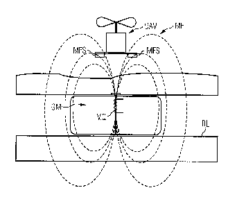
A system for determining the location of pipelines using at
least one geopig that is introduced into a pipeline, advances
therein and that has a magnetic source for generating a
magnetic field, wherein at least one unmanned aerial vehicle is
provided with magnetic field sensors and position determination
devices, a controller is provided for determining the field
strength profile of the magnetic field and for positioning the
unmanned aerial vehicle at a defined distance from the at least
one geopig, and a device is provided for determining the
location Of the at least one geopig from the position of the
unmanned aerial vehicle and the defined distance between the at
least one geopig and the unmanned aerial vehicle.


French Abstract

L'invention concerne un système de détermination de la position de canalisations à l'aide d'au moins une géo-sonde qui est introduite dans une canalisation, qui se déplace à l'intérieur et qui possède une source magnétique destinée à générer un champ magnétique. Au moins un drone (UAV) est équipé de capteurs de champ magnétique (MFS) et de moyens de positionnement. Des moyens de commande sont prévus pour déterminer l'allure du champ du champ magnétique (MF) et positionner le drone (UAV) à une distance définie de la géo-sonde (GM). Des moyens sont prévus pour déterminer la position de la géo-sonde (GM) à partir de la position du drone (UAV) et de la distance définie entre la géo-sonde (GM) et le drone (UAV).

Claims

Note: Claims are shown in the official language in which they were submitted.


, .
85231621
8
CLAIMS:
1. A system for determining the location of pipelines
having at least one geopig which is introduced into a pipeline,
moves forward in said pipeline and which comprises a magnetic
source for generating a magnetic field, the system comprising:
at least one unmanned aerial vehicle having
magnetic field sensors and position determining
devices;
a controller for determining a course of a field
strength of the magnetic field and for positioning
the unmanned aerial vehicle at a defined distance
from the at least one geopig; and
means for determining a location of the geopig
from a position of the unmanned aerial vehicle and a
defined distance between the at least one geopig and
the unmanned aerial vehicle.
2. The system as claimed in claim 1, wherein the
position determining devices of the unmanned aerial vehicle
comprise satellite navigation components.
3. The system as claimed in claim 1, wherein the at
least one geopig is moved forward via flow of the medium being
transported in the pipeline.
4. The system as claimed in claim 2, wherein the at
least one geopig is moved forward via flow of the medium being
transported in the pipeline.
CA 3043138 2019-05-30

85231621
9
5. The system as claimed in claim 1, wherein the
location of the pipeline is determined from a sequence of
ascertained positions of the at least one geopig while moving.
6. The system as claimed in claim 2, wherein the
location of the pipeline is determined from a sequence of
ascertained positions of the at least one geopig while moving.
7. The system as claimed in claim 3, wherein the
location of the pipeline is determined from a sequence of
ascertained positions of the at least one geopig while moving.
8. The system as claimed in claim 1, wherein the
magnetic source comprises a coil to which an alternating
current is applied; and wherein the alternating current
comprises a typical and distinguishable frequency pattern.
9. The system as claimed in claim 1, wherein the
magnetic field comprises a constant field having an alternating
field superimposed on said constant field.
CA 3043138 2019-05-30

Description

Note: Descriptions are shown in the official language in which they were submitted.


85231621
1
System for Determining the Location of Pipelines
FIELD OF THE INVENTION
The invention relates to a system for determining the location
of pipelines having at least one geopig that is introduced into
a pipeline and moves forward in the pipeline and comprises a
magnetic source for generating a magnetic field.
BACKGROUND OF THE INVENTION
When performing inspection tasks, it is necessary to know the
very precise location of subsoil pipelines, such as pipelines
for gas, oil, or water. Once these pipelines are laid and the
ground region is restored, the pipelines and particularly the
location of their upper edge are usually no longer visible from
the outside.
During the procedure of laying new pipelines, the location of
the pipelines is recorded with cadastral accuracy using
contemporary methods during the laying procedure, in other
words prior to restoring the ground region. However, in the
past, the locations of older pipelines were not recorded with
sufficient accuracy when laying pipelines. In addition, it is
possible as a result of unstable subsoils, such as marshlands
or desert sand, that the location of the pipeline embedded in
the subsoil changes.
Methods for locating pipelines and accordingly their metal
structure in the ground are known from the prior art.
CA 3043138 2019-05-30

. .
85231621
2
This method is performed close to the surface of the ground by
way of example using hand-held devices, such as devices
marketed by the CORROCONT Group, which favors the transmission
of the coupled measurement signal and thus the sensitivity of
the measuring procedure.
Other methods for the internal inspection of pipelines use
"geopigs" that are introduced into the pipeline and are moved
forward via the flow of the transported medium in the pipeline.
The position of the geopig is determined via inertial measuring
systems.
These systems are encumbered with the disadvantage that their
measurement results drift, i.e., the incremental feed-forward
determination causes error propagation in the results.
Owing to the lack of contact with the outside world, it is not
possible to compensate this error behavior, for instance, via
external and thus absolute measuring procedures, where the
mainly metal structure of the pipeline particularly represents
an obstacle that distorts the transmission of radio signals
(electrical fields) (Faraday cage).
Pigging is described, for example, at Wikipedia. As such, it
is known from the prior art to attach to the outer skin of the
pipeline acoustic or magnetic locating devices or locating
devices that use wireless technology, where the locating
devices can detect the passage of the geopig.
CA 3043138 2019-05-30

. .
85231621
3
This form of sensor technology is, however, not available in
particular for the poorly calibrated locations of older
pipelines.
SUMMARY OF THE INVENTION
In view of the foregoing, it is therefore an object of the
invention to further develop the prior art and in particular
to improve the use of geopigs for surveying pipelines.
This and other objects and advantages are achieved in
accordance with the invention by a system, where at least one
unmanned aerial vehicle is provided with magnetic field sensors
and position determining devices, and a controller is provided
for determining the course of the field strength of a magnetic
field and for positioning the unmanned aerial vehicle at a
defined distance from a geopig and where means are provided for
determining the location of the geopig from the position of the
unmanned aerial vehicle and the defined distance between the
geopig and the unmanned aerial vehicle.
BRIEF DESCRIPTION OF THE DRAWINGS
The invention is explained in detail with reference to the
figures, in which:
Fig. 1 shows the use of a system in accordance with the
invention in a schematic and side view; and
Fig. 2 shows the use of the system in accordance with the
invention in a plan view.
CA 3043138 2019-05-30

85231621
4
DETAILED DESCRIPTION OF THE EXEMPLARY EMBODIMENTS
The figures illustrate the use of a geopig GM for determining
the location of a pipeline RL.
The geopig GM is equipped with a magnetic source MQ that
generates a magnetic field. The course of the field strength of
the magnetic field is detected via a magnetic field sensor MFS
that is attached to an unmanned aerial vehicle UAV and
spatially allocated.
The unmanned aerial vehicle UAV follows the maximum of the
magnetic signal at a predetermined flight height and positions
itself in each case at a defined distance from the geopig GM,
by way of example, directly above the geopig GM.
Therefore, the movement of the geopig GM in the pipeline RL
also causes the unmanned aerial vehicle UAV to follow the
course of the pipeline RL.
The location and course of the pipeline RL are ascertained from
the position of the unmanned aerial vehicle UAV, which is
continuously determined using satellite navigation, and from
the distance between the geopig GM and the unmanned aerial
vehicle UAV, where distance is determinable from the course of
the field strength of the magnetic field MF.
In so doing, it is expedient if the data that is obtained using
inertial measuring systems and that relates to the position of
CA 3043138 2019-05-30

85231621
the geopig is likewise used in the procedure of determining the
location and course of the pipeline RL.
Permanent magnets or magnetic coils are, by way of example,
5 conceivable as the magnetic source.
It is advantageous to use a coil to which an alternating
current is applied as a magnetic source MQ for generating an
alternating magnetic field MF at an impressed frequency
signature, with the result that it is possible to identify
interference signals.
It is expedient for this purpose if the frequency and field
strength of the magnetic field MF are adjusted to suit the
characteristics of the pipeline RL in order that the eddy
currents that are induced therein are minimal.
It is also advantageously possible to configure the magnetic
field MF as a constant field that has an alternating field
superimposed on it because it is possible to improve the
alternating field permeability of magnetic materials by
superimposing the alternating field on a constant field that
magnetically saturates the material at a corresponding point.
In order to avoid the pig magnetically attaching itself to the
surrounding pipe, the magnetic constant field should continue
to extend within the pipe as symmetrically possible.
It may also be advantageous to equip the unmanned aerial
vehicle UAV with a plurality of magnetic field sensors MFS and
to arrange these sensors in the form of a cross, as is
CA 3043138 2019-05-30

. .
85231621
6
illustrated in Fig. 2. Consequently, the localization of the
geopig GM and thus of the pipeline RL is improved in the
lateral direction by virtue of the detection results being at a
maximum.
In a further advantageous embodiment of the invention, the
magnetic field is also used simultaneously for detecting weak
points in the pipeline casing or for detecting irregularities
in the ground lying above the pipeline (for example, "illegal
tapping" via attaching branch lines).
A bi-directional measurement would also be conceivable, in that
the signal that is measured via the magnetic field probe MFS is
returned, for example, at another lower frequency to the geopig
GM. As a consequence, it is possible using suitable coding over
the propagation delay time of the signals to determine the
distance between the unmanned aerial vehicle UAV and the geopig
GM.
Alternatively, it would also be conceivable to measure the
distance by comparing the phase position of the signals.
The advantages that are achieved using the system in accordance
with the invention particularly reside in a high degree of
accuracy when determining the position of the geopig GM, above
all in the case of comparatively long pipelines RL, by
eliminating the drift behavior of the incremental measurement
using an inertial measuring system.
Consequently, it is also possible to use comparatively simple
and cost-effective measuring systems in the geopig GM.
CA 3043138 2019-05-30

85231621
7
Furthermore, the system renders it possible to fully automate
the measuring procedure.
Thus, while there have been shown, described and pointed out
fundamental novel features of the invention as applied to a
preferred embodiment thereof, it will be understood that
various omissions and substitutions and changes in the form and
details of the devices illustrated, and in their operation, may
be made by those skilled in the art without departing from the
spirit of the invention. For example, it is expressly intended
that all combinations of those elements and/or method steps
which perform substantially the same function in substantially
the same way to achieve the same results are within the scope
of the invention. Moreover, it should be recognized that
structures and/or elements shown and/or described in connection
with any disclosed form or embodiment of the invention may be
incorporated in any other disclosed or described or suggested
form or embodiment as a general matter of design choice. It is
the intention, therefore, to be limited only as indicated by
the scope of the claims appended hereto.
CA 3043138 2019-05-30

Representative Drawing
A single figure which represents the drawing illustrating the invention.
Administrative Status

2024-08-01:As part of the Next Generation Patents (NGP) transition, the Canadian Patents Database (CPD) now contains a more detailed Event History, which replicates the Event Log of our new back-office solution.

Please note that "Inactive:" events refers to events no longer in use in our new back-office solution.

For a clearer understanding of the status of the application/patent presented on this page, the site Disclaimer , as well as the definitions for Patent , Event History , Maintenance Fee  and Payment History  should be consulted.

Event History

Description Date
Inactive: Recording certificate (Transfer) 2023-02-23
Inactive: Multiple transfers 2023-01-25
Inactive: Grant downloaded 2021-11-10
Grant by Issuance 2021-11-09
Letter Sent 2021-11-09
Inactive: Cover page published 2021-11-08
Pre-grant 2021-09-16
Inactive: Final fee received 2021-09-16
Notice of Allowance is Issued 2021-05-21
Letter Sent 2021-05-21
Notice of Allowance is Issued 2021-05-21
Inactive: QS passed 2021-05-05
Inactive: Approved for allowance (AFA) 2021-05-05
Common Representative Appointed 2020-11-07
Amendment Received - Voluntary Amendment 2020-10-22
Examiner's Report 2020-07-07
Inactive: Report - No QC 2020-07-02
Common Representative Appointed 2019-10-30
Inactive: Cover page published 2019-05-30
Amendment Received - Voluntary Amendment 2019-05-30
Inactive: Acknowledgment of national entry - RFE 2019-05-28
Inactive: First IPC assigned 2019-05-17
Letter Sent 2019-05-17
Inactive: IPC assigned 2019-05-17
Application Received - PCT 2019-05-17
National Entry Requirements Determined Compliant 2019-05-07
Request for Examination Requirements Determined Compliant 2019-05-07
All Requirements for Examination Determined Compliant 2019-05-07
Application Published (Open to Public Inspection) 2018-06-07

Abandonment History

There is no abandonment history.

Maintenance Fee

The last payment was received on 2021-10-25

Note : If the full payment has not been received on or before the date indicated, a further fee may be required which may be one of the following

  • the reinstatement fee;
  • the late payment fee; or
  • additional fee to reverse deemed expiry.

Patent fees are adjusted on the 1st of January every year. The amounts above are the current amounts if received by December 31 of the current year.
Please refer to the CIPO Patent Fees web page to see all current fee amounts.

Fee History

Fee Type Anniversary Year Due Date Paid Date
Request for examination - standard 2019-05-07
Basic national fee - standard 2019-05-07
MF (application, 2nd anniv.) - standard 02 2019-11-08 2019-10-07
MF (application, 3rd anniv.) - standard 03 2020-11-09 2020-10-30
Final fee - standard 2021-09-21 2021-09-16
MF (application, 4th anniv.) - standard 04 2021-11-08 2021-10-25
MF (patent, 5th anniv.) - standard 2022-11-08 2022-10-31
Registration of a document 2023-01-25
MF (patent, 6th anniv.) - standard 2023-11-08 2023-10-11
Owners on Record

Note: Records showing the ownership history in alphabetical order.

Current Owners on Record
SIEMENS ENERGY GLOBAL GMBH & CO. KG
Past Owners on Record
JOSEF ALOIS BIRCHBAUER
KLAUS LUDWIG
MARKUS RICHTER
UWE LINNERT
Past Owners that do not appear in the "Owners on Record" listing will appear in other documentation within the application.
Documents

To view selected files, please enter reCAPTCHA code :


To view images, click a link in the Document Description column (Temporarily unavailable). To download the documents, select one or more checkboxes in the first column and then click the "Download Selected in PDF format (Zip Archive)" or the "Download Selected as Single PDF" button.

List of published and non-published patent-specific documents on the CPD .

If you have any difficulty accessing content, you can call the Client Service Centre at 1-866-997-1936 or send them an e-mail at CIPO Client Service Centre.

({010=All Documents, 020=As Filed, 030=As Open to Public Inspection, 040=At Issuance, 050=Examination, 060=Incoming Correspondence, 070=Miscellaneous, 080=Outgoing Correspondence, 090=Payment})


Document
Description 
Date
(yyyy-mm-dd) 
Number of pages   Size of Image (KB) 
Drawings 2019-05-06 1 17
Claims 2019-05-06 2 43
Abstract 2019-05-06 1 17
Description 2019-05-06 7 188
Representative drawing 2019-05-06 1 8
Abstract 2019-05-29 1 20
Claims 2019-05-29 2 55
Description 2019-05-29 7 238
Representative drawing 2021-10-19 1 6
Acknowledgement of Request for Examination 2019-05-16 1 174
Notice of National Entry 2019-05-27 1 202
Reminder of maintenance fee due 2019-07-08 1 111
Commissioner's Notice - Application Found Allowable 2021-05-20 1 548
Electronic Grant Certificate 2021-11-08 1 2,527
Amendment - Abstract 2019-05-06 2 88
International search report 2019-05-06 6 168
National entry request 2019-05-06 3 70
Amendment / response to report 2019-05-29 21 676
Examiner requisition 2020-07-06 4 225
Amendment / response to report 2020-10-21 5 158
Final fee 2021-09-15 5 135