Sélection de la langue

Search

Sommaire du brevet 3043138 

Énoncé de désistement de responsabilité concernant l'information provenant de tiers

Une partie des informations de ce site Web a été fournie par des sources externes. Le gouvernement du Canada n'assume aucune responsabilité concernant la précision, l'actualité ou la fiabilité des informations fournies par les sources externes. Les utilisateurs qui désirent employer cette information devraient consulter directement la source des informations. Le contenu fourni par les sources externes n'est pas assujetti aux exigences sur les langues officielles, la protection des renseignements personnels et l'accessibilité.

Disponibilité de l'Abrégé et des Revendications

L'apparition de différences dans le texte et l'image des Revendications et de l'Abrégé dépend du moment auquel le document est publié. Les textes des Revendications et de l'Abrégé sont affichés :

  • lorsque la demande peut être examinée par le public;
  • lorsque le brevet est émis (délivrance).
(12) Brevet: (11) CA 3043138
(54) Titre français: SYSTEME DE DETERMINATION DE LA POSITION DE CANALISATIONS
(54) Titre anglais: SYSTEM FOR DETERMINING THE LOCATION OF PIPELINES
Statut: Accordé et délivré
Données bibliographiques
(51) Classification internationale des brevets (CIB):
  • G01V 03/08 (2006.01)
  • F16L 55/48 (2006.01)
  • G01V 03/15 (2006.01)
  • G01V 03/16 (2006.01)
(72) Inventeurs :
  • BIRCHBAUER, JOSEF ALOIS (Autriche)
  • LINNERT, UWE (Allemagne)
  • LUDWIG, KLAUS (Allemagne)
  • RICHTER, MARKUS (Allemagne)
(73) Titulaires :
  • SIEMENS ENERGY GLOBAL GMBH & CO. KG
(71) Demandeurs :
  • SIEMENS ENERGY GLOBAL GMBH & CO. KG (Allemagne)
(74) Agent: SMART & BIGGAR LP
(74) Co-agent:
(45) Délivré: 2021-11-09
(86) Date de dépôt PCT: 2017-11-08
(87) Mise à la disponibilité du public: 2018-06-07
Requête d'examen: 2019-05-07
Licence disponible: S.O.
Cédé au domaine public: S.O.
(25) Langue des documents déposés: Anglais

Traité de coopération en matière de brevets (PCT): Oui
(86) Numéro de la demande PCT: PCT/EP2017/078546
(87) Numéro de publication internationale PCT: EP2017078546
(85) Entrée nationale: 2019-05-07

(30) Données de priorité de la demande:
Numéro de la demande Pays / territoire Date
10 2016 223 774.8 (Allemagne) 2016-11-30

Abrégés

Abrégé français

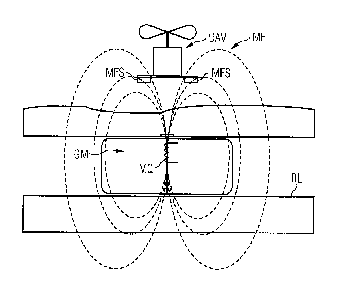
L'invention concerne un système de détermination de la position de canalisations à l'aide d'au moins une géo-sonde qui est introduite dans une canalisation, qui se déplace à l'intérieur et qui possède une source magnétique destinée à générer un champ magnétique. Au moins un drone (UAV) est équipé de capteurs de champ magnétique (MFS) et de moyens de positionnement. Des moyens de commande sont prévus pour déterminer l'allure du champ du champ magnétique (MF) et positionner le drone (UAV) à une distance définie de la géo-sonde (GM). Des moyens sont prévus pour déterminer la position de la géo-sonde (GM) à partir de la position du drone (UAV) et de la distance définie entre la géo-sonde (GM) et le drone (UAV).


Abrégé anglais


A system for determining the location of pipelines using at
least one geopig that is introduced into a pipeline, advances
therein and that has a magnetic source for generating a
magnetic field, wherein at least one unmanned aerial vehicle is
provided with magnetic field sensors and position determination
devices, a controller is provided for determining the field
strength profile of the magnetic field and for positioning the
unmanned aerial vehicle at a defined distance from the at least
one geopig, and a device is provided for determining the
location Of the at least one geopig from the position of the
unmanned aerial vehicle and the defined distance between the at
least one geopig and the unmanned aerial vehicle.

Revendications

Note : Les revendications sont présentées dans la langue officielle dans laquelle elles ont été soumises.


, .
85231621
8
CLAIMS:
1. A system for determining the location of pipelines
having at least one geopig which is introduced into a pipeline,
moves forward in said pipeline and which comprises a magnetic
source for generating a magnetic field, the system comprising:
at least one unmanned aerial vehicle having
magnetic field sensors and position determining
devices;
a controller for determining a course of a field
strength of the magnetic field and for positioning
the unmanned aerial vehicle at a defined distance
from the at least one geopig; and
means for determining a location of the geopig
from a position of the unmanned aerial vehicle and a
defined distance between the at least one geopig and
the unmanned aerial vehicle.
2. The system as claimed in claim 1, wherein the
position determining devices of the unmanned aerial vehicle
comprise satellite navigation components.
3. The system as claimed in claim 1, wherein the at
least one geopig is moved forward via flow of the medium being
transported in the pipeline.
4. The system as claimed in claim 2, wherein the at
least one geopig is moved forward via flow of the medium being
transported in the pipeline.
CA 3043138 2019-05-30

85231621
9
5. The system as claimed in claim 1, wherein the
location of the pipeline is determined from a sequence of
ascertained positions of the at least one geopig while moving.
6. The system as claimed in claim 2, wherein the
location of the pipeline is determined from a sequence of
ascertained positions of the at least one geopig while moving.
7. The system as claimed in claim 3, wherein the
location of the pipeline is determined from a sequence of
ascertained positions of the at least one geopig while moving.
8. The system as claimed in claim 1, wherein the
magnetic source comprises a coil to which an alternating
current is applied; and wherein the alternating current
comprises a typical and distinguishable frequency pattern.
9. The system as claimed in claim 1, wherein the
magnetic field comprises a constant field having an alternating
field superimposed on said constant field.
CA 3043138 2019-05-30

Description

Note : Les descriptions sont présentées dans la langue officielle dans laquelle elles ont été soumises.


85231621
1
System for Determining the Location of Pipelines
FIELD OF THE INVENTION
The invention relates to a system for determining the location
of pipelines having at least one geopig that is introduced into
a pipeline and moves forward in the pipeline and comprises a
magnetic source for generating a magnetic field.
BACKGROUND OF THE INVENTION
When performing inspection tasks, it is necessary to know the
very precise location of subsoil pipelines, such as pipelines
for gas, oil, or water. Once these pipelines are laid and the
ground region is restored, the pipelines and particularly the
location of their upper edge are usually no longer visible from
the outside.
During the procedure of laying new pipelines, the location of
the pipelines is recorded with cadastral accuracy using
contemporary methods during the laying procedure, in other
words prior to restoring the ground region. However, in the
past, the locations of older pipelines were not recorded with
sufficient accuracy when laying pipelines. In addition, it is
possible as a result of unstable subsoils, such as marshlands
or desert sand, that the location of the pipeline embedded in
the subsoil changes.
Methods for locating pipelines and accordingly their metal
structure in the ground are known from the prior art.
CA 3043138 2019-05-30

. .
85231621
2
This method is performed close to the surface of the ground by
way of example using hand-held devices, such as devices
marketed by the CORROCONT Group, which favors the transmission
of the coupled measurement signal and thus the sensitivity of
the measuring procedure.
Other methods for the internal inspection of pipelines use
"geopigs" that are introduced into the pipeline and are moved
forward via the flow of the transported medium in the pipeline.
The position of the geopig is determined via inertial measuring
systems.
These systems are encumbered with the disadvantage that their
measurement results drift, i.e., the incremental feed-forward
determination causes error propagation in the results.
Owing to the lack of contact with the outside world, it is not
possible to compensate this error behavior, for instance, via
external and thus absolute measuring procedures, where the
mainly metal structure of the pipeline particularly represents
an obstacle that distorts the transmission of radio signals
(electrical fields) (Faraday cage).
Pigging is described, for example, at Wikipedia. As such, it
is known from the prior art to attach to the outer skin of the
pipeline acoustic or magnetic locating devices or locating
devices that use wireless technology, where the locating
devices can detect the passage of the geopig.
CA 3043138 2019-05-30

. .
85231621
3
This form of sensor technology is, however, not available in
particular for the poorly calibrated locations of older
pipelines.
SUMMARY OF THE INVENTION
In view of the foregoing, it is therefore an object of the
invention to further develop the prior art and in particular
to improve the use of geopigs for surveying pipelines.
This and other objects and advantages are achieved in
accordance with the invention by a system, where at least one
unmanned aerial vehicle is provided with magnetic field sensors
and position determining devices, and a controller is provided
for determining the course of the field strength of a magnetic
field and for positioning the unmanned aerial vehicle at a
defined distance from a geopig and where means are provided for
determining the location of the geopig from the position of the
unmanned aerial vehicle and the defined distance between the
geopig and the unmanned aerial vehicle.
BRIEF DESCRIPTION OF THE DRAWINGS
The invention is explained in detail with reference to the
figures, in which:
Fig. 1 shows the use of a system in accordance with the
invention in a schematic and side view; and
Fig. 2 shows the use of the system in accordance with the
invention in a plan view.
CA 3043138 2019-05-30

85231621
4
DETAILED DESCRIPTION OF THE EXEMPLARY EMBODIMENTS
The figures illustrate the use of a geopig GM for determining
the location of a pipeline RL.
The geopig GM is equipped with a magnetic source MQ that
generates a magnetic field. The course of the field strength of
the magnetic field is detected via a magnetic field sensor MFS
that is attached to an unmanned aerial vehicle UAV and
spatially allocated.
The unmanned aerial vehicle UAV follows the maximum of the
magnetic signal at a predetermined flight height and positions
itself in each case at a defined distance from the geopig GM,
by way of example, directly above the geopig GM.
Therefore, the movement of the geopig GM in the pipeline RL
also causes the unmanned aerial vehicle UAV to follow the
course of the pipeline RL.
The location and course of the pipeline RL are ascertained from
the position of the unmanned aerial vehicle UAV, which is
continuously determined using satellite navigation, and from
the distance between the geopig GM and the unmanned aerial
vehicle UAV, where distance is determinable from the course of
the field strength of the magnetic field MF.
In so doing, it is expedient if the data that is obtained using
inertial measuring systems and that relates to the position of
CA 3043138 2019-05-30

85231621
the geopig is likewise used in the procedure of determining the
location and course of the pipeline RL.
Permanent magnets or magnetic coils are, by way of example,
5 conceivable as the magnetic source.
It is advantageous to use a coil to which an alternating
current is applied as a magnetic source MQ for generating an
alternating magnetic field MF at an impressed frequency
signature, with the result that it is possible to identify
interference signals.
It is expedient for this purpose if the frequency and field
strength of the magnetic field MF are adjusted to suit the
characteristics of the pipeline RL in order that the eddy
currents that are induced therein are minimal.
It is also advantageously possible to configure the magnetic
field MF as a constant field that has an alternating field
superimposed on it because it is possible to improve the
alternating field permeability of magnetic materials by
superimposing the alternating field on a constant field that
magnetically saturates the material at a corresponding point.
In order to avoid the pig magnetically attaching itself to the
surrounding pipe, the magnetic constant field should continue
to extend within the pipe as symmetrically possible.
It may also be advantageous to equip the unmanned aerial
vehicle UAV with a plurality of magnetic field sensors MFS and
to arrange these sensors in the form of a cross, as is
CA 3043138 2019-05-30

. .
85231621
6
illustrated in Fig. 2. Consequently, the localization of the
geopig GM and thus of the pipeline RL is improved in the
lateral direction by virtue of the detection results being at a
maximum.
In a further advantageous embodiment of the invention, the
magnetic field is also used simultaneously for detecting weak
points in the pipeline casing or for detecting irregularities
in the ground lying above the pipeline (for example, "illegal
tapping" via attaching branch lines).
A bi-directional measurement would also be conceivable, in that
the signal that is measured via the magnetic field probe MFS is
returned, for example, at another lower frequency to the geopig
GM. As a consequence, it is possible using suitable coding over
the propagation delay time of the signals to determine the
distance between the unmanned aerial vehicle UAV and the geopig
GM.
Alternatively, it would also be conceivable to measure the
distance by comparing the phase position of the signals.
The advantages that are achieved using the system in accordance
with the invention particularly reside in a high degree of
accuracy when determining the position of the geopig GM, above
all in the case of comparatively long pipelines RL, by
eliminating the drift behavior of the incremental measurement
using an inertial measuring system.
Consequently, it is also possible to use comparatively simple
and cost-effective measuring systems in the geopig GM.
CA 3043138 2019-05-30

85231621
7
Furthermore, the system renders it possible to fully automate
the measuring procedure.
Thus, while there have been shown, described and pointed out
fundamental novel features of the invention as applied to a
preferred embodiment thereof, it will be understood that
various omissions and substitutions and changes in the form and
details of the devices illustrated, and in their operation, may
be made by those skilled in the art without departing from the
spirit of the invention. For example, it is expressly intended
that all combinations of those elements and/or method steps
which perform substantially the same function in substantially
the same way to achieve the same results are within the scope
of the invention. Moreover, it should be recognized that
structures and/or elements shown and/or described in connection
with any disclosed form or embodiment of the invention may be
incorporated in any other disclosed or described or suggested
form or embodiment as a general matter of design choice. It is
the intention, therefore, to be limited only as indicated by
the scope of the claims appended hereto.
CA 3043138 2019-05-30

Dessin représentatif
Une figure unique qui représente un dessin illustrant l'invention.
États administratifs

2024-08-01 : Dans le cadre de la transition vers les Brevets de nouvelle génération (BNG), la base de données sur les brevets canadiens (BDBC) contient désormais un Historique d'événement plus détaillé, qui reproduit le Journal des événements de notre nouvelle solution interne.

Veuillez noter que les événements débutant par « Inactive : » se réfèrent à des événements qui ne sont plus utilisés dans notre nouvelle solution interne.

Pour une meilleure compréhension de l'état de la demande ou brevet qui figure sur cette page, la rubrique Mise en garde , et les descriptions de Brevet , Historique d'événement , Taxes périodiques et Historique des paiements devraient être consultées.

Historique d'événement

Description Date
Inactive : Certificat d'inscription (Transfert) 2023-02-23
Inactive : Transferts multiples 2023-01-25
Inactive : Octroit téléchargé 2021-11-10
Accordé par délivrance 2021-11-09
Lettre envoyée 2021-11-09
Inactive : Page couverture publiée 2021-11-08
Préoctroi 2021-09-16
Inactive : Taxe finale reçue 2021-09-16
Un avis d'acceptation est envoyé 2021-05-21
Lettre envoyée 2021-05-21
Un avis d'acceptation est envoyé 2021-05-21
Inactive : QS réussi 2021-05-05
Inactive : Approuvée aux fins d'acceptation (AFA) 2021-05-05
Représentant commun nommé 2020-11-07
Modification reçue - modification volontaire 2020-10-22
Rapport d'examen 2020-07-07
Inactive : Rapport - Aucun CQ 2020-07-02
Représentant commun nommé 2019-10-30
Inactive : Page couverture publiée 2019-05-30
Modification reçue - modification volontaire 2019-05-30
Inactive : Acc. récept. de l'entrée phase nat. - RE 2019-05-28
Inactive : CIB en 1re position 2019-05-17
Lettre envoyée 2019-05-17
Inactive : CIB attribuée 2019-05-17
Demande reçue - PCT 2019-05-17
Exigences pour l'entrée dans la phase nationale - jugée conforme 2019-05-07
Exigences pour une requête d'examen - jugée conforme 2019-05-07
Toutes les exigences pour l'examen - jugée conforme 2019-05-07
Demande publiée (accessible au public) 2018-06-07

Historique d'abandonnement

Il n'y a pas d'historique d'abandonnement

Taxes périodiques

Le dernier paiement a été reçu le 2021-10-25

Avis : Si le paiement en totalité n'a pas été reçu au plus tard à la date indiquée, une taxe supplémentaire peut être imposée, soit une des taxes suivantes :

  • taxe de rétablissement ;
  • taxe pour paiement en souffrance ; ou
  • taxe additionnelle pour le renversement d'une péremption réputée.

Les taxes sur les brevets sont ajustées au 1er janvier de chaque année. Les montants ci-dessus sont les montants actuels s'ils sont reçus au plus tard le 31 décembre de l'année en cours.
Veuillez vous référer à la page web des taxes sur les brevets de l'OPIC pour voir tous les montants actuels des taxes.

Historique des taxes

Type de taxes Anniversaire Échéance Date payée
Requête d'examen - générale 2019-05-07
Taxe nationale de base - générale 2019-05-07
TM (demande, 2e anniv.) - générale 02 2019-11-08 2019-10-07
TM (demande, 3e anniv.) - générale 03 2020-11-09 2020-10-30
Taxe finale - générale 2021-09-21 2021-09-16
TM (demande, 4e anniv.) - générale 04 2021-11-08 2021-10-25
TM (brevet, 5e anniv.) - générale 2022-11-08 2022-10-31
Enregistrement d'un document 2023-01-25
TM (brevet, 6e anniv.) - générale 2023-11-08 2023-10-11
Titulaires au dossier

Les titulaires actuels et antérieures au dossier sont affichés en ordre alphabétique.

Titulaires actuels au dossier
SIEMENS ENERGY GLOBAL GMBH & CO. KG
Titulaires antérieures au dossier
JOSEF ALOIS BIRCHBAUER
KLAUS LUDWIG
MARKUS RICHTER
UWE LINNERT
Les propriétaires antérieurs qui ne figurent pas dans la liste des « Propriétaires au dossier » apparaîtront dans d'autres documents au dossier.
Documents

Pour visionner les fichiers sélectionnés, entrer le code reCAPTCHA :


Pour visualiser une image, cliquer sur un lien dans la colonne description du document (Temporairement non-disponible). Pour télécharger l'image (les images), cliquer l'une ou plusieurs cases à cocher dans la première colonne et ensuite cliquer sur le bouton "Télécharger sélection en format PDF (archive Zip)" ou le bouton "Télécharger sélection (en un fichier PDF fusionné)".

Liste des documents de brevet publiés et non publiés sur la BDBC .

Si vous avez des difficultés à accéder au contenu, veuillez communiquer avec le Centre de services à la clientèle au 1-866-997-1936, ou envoyer un courriel au Centre de service à la clientèle de l'OPIC.

({010=Tous les documents, 020=Au moment du dépôt, 030=Au moment de la mise à la disponibilité du public, 040=À la délivrance, 050=Examen, 060=Correspondance reçue, 070=Divers, 080=Correspondance envoyée, 090=Paiement})


Description du
Document 
Date
(aaaa-mm-jj) 
Nombre de pages   Taille de l'image (Ko) 
Dessins 2019-05-06 1 17
Revendications 2019-05-06 2 43
Abrégé 2019-05-06 1 17
Description 2019-05-06 7 188
Dessin représentatif 2019-05-06 1 8
Abrégé 2019-05-29 1 20
Revendications 2019-05-29 2 55
Description 2019-05-29 7 238
Dessin représentatif 2021-10-19 1 6
Accusé de réception de la requête d'examen 2019-05-16 1 174
Avis d'entree dans la phase nationale 2019-05-27 1 202
Rappel de taxe de maintien due 2019-07-08 1 111
Avis du commissaire - Demande jugée acceptable 2021-05-20 1 548
Certificat électronique d'octroi 2021-11-08 1 2 527
Modification - Abrégé 2019-05-06 2 88
Rapport de recherche internationale 2019-05-06 6 168
Demande d'entrée en phase nationale 2019-05-06 3 70
Modification / réponse à un rapport 2019-05-29 21 676
Demande de l'examinateur 2020-07-06 4 225
Modification / réponse à un rapport 2020-10-21 5 158
Taxe finale 2021-09-15 5 135