Note: Descriptions are shown in the official language in which they were submitted.
SYSTEM AND METHOD FOR ANALYZING VEHICLE DATA
TECHNICAL FIELD
[0001] The following relates generally to analyzing vehicle data.
BACKGROUND
[0002] Usage-based insurance (UBI) is a type of vehicle insurance that may
be used
to set or adjust the cost of a premium paid by a user based on factors such as
the
driving habits of the user, the type of vehicle being used, how often the
vehicle is used,
or where the vehicle is being used, to name a few. UBI may also be referred to
as "pay
as you drive" or "pay how you drive" insurance. UBI programs typically require
a device
to be installed in or coupled to a vehicle or require an application to be
installed in
another device such as a smart phone that is meant to be located in the
vehicle while
the user is driving. Such devices or applications are often referred to as
telematics
devices or telematics applications and are normally connectable to a
telematics system
that collects driver data for several users.
[0003] With the collected data, a UBI program may analyze certain variables
for a
UBI model. For example, speed, acceleration, and distance variables may be
determined from the collected data and used in a UBI model to rate the driver.
Many
auto rating variables for such UBI models are not causal. Instead, many of
these
variables serve as a proxy to the cause of a change to the variable. Using
proxy
variables can increase the variance of the estimates and thus the overall
premiums
calculated in a UBI program.
[0004] Issues with auto rating variables can lead to issues in fairness in
that, for
example, not all young drivers are necessarily high-risk drivers. Moreover,
using
variables such as gender, age, territory, and marital status can lead to
potential issues
with discrimination. Due to these factors, some regions control or even forbid
the use of
such variables in determining insurance premiums.
-1 -
23714293.1
CA 3052159 2019-08-15
SUMMARY
[0005] Certain example systems and methods described herein enable vehicle
data
that has been collected in a telematics system to be used in determining
driving
patterns, e.g., for UBI pricing. In one aspect, there is provided a device for
analyzing
vehicle data. The device includes a processor, a data interface coupled to the
processor, and a memory coupled to the processor. The memory stores computer
executable instructions that when executed by the processor cause the
processor to
obtain a set of vehicle data via the data interface, the set of vehicle data
comprising a
plurality of location measurements and a corresponding plurality of speed
measurements for a vehicle. The computer executable instructions also cause
the
processor to associate the plurality of location measurements and the
plurality of speed
measurements with a geographic area to generate a geographic map image and
apply
an image processing technique to the map image to identify at least one path.
The
computer executable instructions also cause the processor to analyze the at
least one
path and data associated with the geographic area, to identify at least one
driving
pattern within the geographic area, and provide an indication of the at least
one driving
pattern to contribute to a risk assessment associated with a driver of the
vehicle.
[0006] In another aspect, there is provided a method of analyzing vehicle
data. The
method is executed by a device having a processor and includes obtaining a set
of
vehicle data via a data interface, the set of vehicle data comprising a
plurality of location
measurements and a corresponding plurality of speed measurements for a
vehicle. The
method also includes associating the plurality of location measurements and
the
plurality of speed measurements with a geographic area to generate a
geographic map
image and applying an image processing technique to the map image to identify
at least
one path. The method also includes analyzing the at least one path and data
associated with the geographic area, to identify at least one driving pattern
within the
geographic area and providing an indication of the at least one driving
pattern to
contribute to a risk assessment associated with a driver of the vehicle.
-2-
23714293.1
CA 3052159 2019-08-15
[0007] In another aspect, there is provided non-transitory computer
readable
medium for analyzing vehicle data. The computer readable medium includes
computer
executable instructions for obtaining a set of vehicle data via a data
interface, the set of
vehicle data comprising a plurality of location measurements and a
corresponding
plurality of speed measurements for a vehicle. The computer readable medium
further
includes computer executable instructions for associating the plurality of
location
measurements and the plurality of speed measurements with a geographic area to
generate a geographic map image and applying an image processing technique to
the
map image to identify at least one path. The computer readable medium further
includes computer executable instructions for analyzing the at least one path
and data
associated with the geographic area, to identify at least one driving pattern
within the
geographic area and providing an indication of the at least one driving
pattern to
contribute to a risk assessment associated with a driver of the vehicle.
BRIEF DESCRIPTION OF THE DRAWINGS
[0008] Embodiments will now be described with reference to the appended
drawings wherein:
[0009] FIG. 1 is a schematic diagram of an example computing environment.
[0010] FIG. 2 is a block diagram of an example configuration of a driving
pattern
analysis system.
[0011] FIG. 3 is a block diagram of an example configuration of a
telematics device.
[0012] FIG. 4 is a block diagram of an example configuration of a
telematics
system.
[0013] FIG. 5 is an example of a graphical output displaying driving paths
in a
geographic area.
[0014] FIG. 6 is an example of a graphical output displaying speed maps in
a
geographic area.
-3-
23714293.1
CA 3052159 2019-08-15
[0015] FIG. 7 is a flow diagram of an example of computer executable
instructions
for collecting vehicle data for a driving pattern analysis.
[0016] FIG. 8 is a flow diagram of an example of computer executable
instructions
for analyzing vehicle data.
DETAILED DESCRIPTION
[0017] It will be appreciated that for simplicity and clarity of
illustration, where
considered appropriate, reference numerals may be repeated among the figures
to
indicate corresponding or analogous elements. In addition, numerous specific
details
are set forth in order to provide a thorough understanding of the example
embodiments
described herein. However, it will be understood by those of ordinary skill in
the art that
the example embodiments described herein may be practiced without these
specific
details. In other instances, well-known methods, procedures and components
have not
been described in detail so as not to obscure the example embodiments
described
herein. Also, the description is not to be considered as limiting the scope of
the example
embodiments described herein.
[0018] A cause of risk in providing auto insurance can be linked to driving
habits.
Driving habits can be accurately portrayed using a customer's vehicle
position, speed,
and acceleration at each point in time. Such data points can be collected, for
example,
on a second-by-second basis and used to assess risk. This provides an
opportunity to
improve the pricing scheme used in a UBI system in order to be fairer and more
accurate. A system and method may be provided that leverage such data to
create a
risk assessment process based on long term driving habits. Image processing
and
analysis techniques may be used to identify and analyze driving paths and
speed maps
of users in order to assess risks related to driving patterns. Deep learning
may also be
applied to build a model based on the paths and the data associated with these
paths
(e.g., frequency of use, speed at different portions, etc.). The assessed
risks can be
provided to or used by a pricing team to apply an improved pricing scheme,
e.g., by
ignoring traditional constraints and to view driving patterns in context
rather than
focusing on individual data points like total speed, number of accelerations,
etc.
-4-
23714293.1
CA 3052159 2019-08-15
[0019] Certain example systems and methods described herein enable vehicle
data
that has been collected in a telematics system to be used in determining
driving
patterns, e.g., for UBI pricing. In one aspect, there is provided a device for
analyzing
vehicle data. The device includes a processor, a data interface coupled to the
processor, and a memory coupled to the processor. The memory stores computer
executable instructions that when executed by the processor cause the
processor to
obtain a set of vehicle data via the data interface, the set of vehicle data
comprising a
plurality of location measurements and a corresponding plurality of speed
measurements for a vehicle. The computer executable instructions also cause
the
processor to associate the plurality of location measurements and the
plurality of speed
measurements with a geographic area to generate a geographic map image and
apply
an image processing technique to the map image to identify at least one path.
The
computer executable instructions also cause the processor to analyze the at
least one
path and data associated with the geographic area, to identify at least one
driving
pattern within the geographic area, and provide an indication of the at least
one driving
pattern to contribute to a risk assessment associated with a driver of the
vehicle.
[0020] In another aspect, there is provided a method of analyzing vehicle
data. The
method is executed by a device having a processor and includes obtaining a set
of
vehicle data via a data interface, the set of vehicle data comprising a
plurality of location
measurements and a corresponding plurality of speed measurements for a
vehicle. The
method also includes associating the plurality of location measurements and
the
plurality of speed measurements with a geographic area to generate a
geographic map
image and applying an image processing technique to the map image to identify
at least
one path. The method also includes analyzing the at least one path and data
associated with the geographic area, to identify at least one driving pattern
within the
geographic area and providing an indication of the at least one driving
pattern to
contribute to a risk assessment associated with a driver of the vehicle.
[0021] In another aspect, there is provided non-transitory computer
readable
medium for analyzing vehicle data. The computer readable medium includes
computer
executable instructions for obtaining a set of vehicle data via a data
interface, the set of
-5-
23714293.1
CA 3052159 2019-08-15
vehicle data comprising a plurality of location measurements and a
corresponding
plurality of speed measurements for a vehicle. The computer readable medium
further
includes computer executable instructions for associating the plurality of
location
measurements and the plurality of speed measurements with a geographic area to
generate a geographic map image and applying an image processing technique to
the
map image to identify at least one path. The computer readable medium further
includes computer executable instructions for analyzing the at least one path
and data
associated with the geographic area, to identify at least one driving pattern
within the
geographic area and providing an indication of the at least one driving
pattern to
contribute to a risk assessment associated with a driver of the vehicle.
[0022] In certain example embodiments, the device may generate or update a
model
with the at least one path using a machine learning algorithm and use the
model to
identify the at least one driving pattern. The device may obtain the model,
the model
having been generated from vehicle data for a plurality of vehicles and update
the
model with the at least one path. The vehicle data collected from the
plurality of
vehicles may comprise at least one similar path traveled by another vehicle.
[0023] In certain example embodiments, the at least one path may include a
driving
path traveled by the vehicle. The map image may include at least one repeated
driving
path that is distinguishable by the image processing technique from at least
one other
driving path to be indicative of a higher frequency of use.
[0024] In certain example embodiments, the at least one path can include a
vehicle
trip with a plurality of portions each identifying respective vehicle speed
data. The
vehicle speed data may include an acceleration value.
[0025] In certain example embodiments, the device may communicate via the
data
interface with a telematics system connected to the vehicle for collecting the
vehicle
data. The device may communicate with a database in the telematics system to
obtain
the vehicle data. The device may communicate with a telematics device used or
having
been used in the vehicle to obtain the vehicle data.
[0026] In certain example embodiments, the indication of the at least one
driving
pattern used in the risk assessment may be used to calculate an insurance
premium for
-6-
23714293.1
CA 3052159 2019-08-15
a usage-based insurance program. The indication of the at least one driving
pattern
may also be combined with one or more additional factors in calculating the
insurance
premium. An additional factor may include a road type associated with the at
least one
path, the road type being determinable from data associated with the
geographic area.
[0027] In certain example embodiments, the plurality of location
measurements each
may include a latitude and a longitude, the set of vehicle data having been
generated at
least in part by a global positioning system receiver positioned in the
vehicle while
collecting the vehicle data.
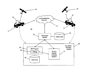
[0028] FIG. 1 illustrates an exemplary computing environment 10 in which a
driving
pattern analysis system 12 communicates with a telematics system 18 to obtain
vehicle
data 20 collected by the telematics system 18 from in-vehicle telematics
devices 16
over a communications network 14. The in-vehicle telematics devices 16 may
include
devices that are embedded in a vehicle 17 (e.g., in-vehicle navigation or
infotainment
systems), devices that are coupled to a data port in the vehicle 17 (e.g.,
dongles or
other custom devices connected to an interface such as an on-board diagnostics
(OBD)
connector), or personal devices associated with a driver or other occupant of
the vehicle
and having a telematics application running thereon (e.g., smartphones, gaming
devices, tablets, etc.). The telematics devices 16 of any of these types, are
capable of
determining data and information that is indicative of the location and speed
of the
vehicle 17 at various points in time. For example, in the configuration shown
in FIG. 1,
the devices 16 are in communication with a global positioning system (GPS)
having a
number of GPS satellites 19 that provide location-based information to an
application
running on or connected to the devices 16. However, it can be appreciated that
other
types of devices 16 such as dongles connected to an OBD port in the vehicle 17
may
have access to at least speed information that is calculated by the vehicle
17.
[0029] In the example configuration shown in FIG. 1, the driving pattern
analysis
system 12 is an entity within an insurance provider system 28. However, it can
be
appreciated that the driving pattern analysis system 12 may also be provided
as a
standalone entity, such as an independent service that can communicate with
multiple
insurance provider systems 28. Similarly, while the telematics system 18 is
shown in
-7-
23714293.1
CA 3052159 2019-08-15
FIG. 1 as a separate entity, the telematics system 18 may also be integrated
into the
insurance provider system 28 or a UBI program 22 within the insurance provider
system
28. The driving pattern analysis system 12 in this example is separate from
and
coupled to at least a pricing module 24 of the UBI program 22. The UBI program
22
may also have access to other data 26 within the insurance provider system 28,
such as
customer data. The UBI program 22, driving pattern analysis system 12, and
telematics
system 18 are delineated as shown in FIG. 1 for illustrative purposes and such
a
configuration should not be considered limiting.
[0030] Details of the insurance provider system 28 are omitted for ease of
illustration
and it will be appreciated that the insurance provider system 28 can be
associated with
a variety of business types, such as insurance providers, financial
institutions having
insurance products, government entities, private lenders, etc.
[0031] The vehicle data 20 that is collected by the telematics system 18
may include
any data that the telematics devices 16 are capable of collecting. For
example, the
telematics devices 16 may typically collect at least latitude and longitude
values
(collectively indicative of a location) and speed values. Other values such as
acceleration can be collected if available or computed based on the location
and speed
values.
[0032] The telematics system 18 and driving pattern analysis system 12 can
include
one or more devices such as servers capable of communicating with each other
and/or
the network 14 and with the insurance provider system 28.
[0033] The driving pattern analysis system 12 may have access to the
vehicle data
20 directly or via the telematics system 18. Such vehicle data 20 may be
accessed via
an Internet or other remote data connection such as an application programming
interface (API).
[0034] In certain aspects, telematics device 16, telematics system 18,
driving pattern
analysis system 12, and UBI program 22 can include, but are not limited to, a
data
communication device; and these may include a mobile or smart phone, a laptop
computer, a tablet computer, a notebook computer, a hand-held computer, a
personal
digital assistant, an embedded device, a virtual reality device, an augmented
reality
-8-
23714293.1
CA 3052159 2019-08-15
device, third party portals, a personal computer, and any additional or
alternate
computing device, and may be operable to transmit and receive data across
communication network 14.
[0035] Communication network 14 may include a telephone network, cellular,
and/or
data communication network to connect different types of devices as will be
described
in greater detail below. For example, the communication network 14 may include
a
private or public switched telephone network (PSTN), mobile network (e.g.,
code
division multiple access (CDMA) network, global system for mobile
communications
(GSM) network, and/or any 3G, 4G, or 5G wireless carrier network, etc.), WiFi
or other
similar wireless network, and a private and/or public wide area network (e.g.,
the
Internet). While the configuration shown in FIG. 1 illustrates the UBI program
22 and
driving pattern analysis system 12 communicating with the communications
network 14
via the telematics system 18, this is done for illustrative purposes and these
devices
may also connect directly to communications network 14. For example, as shown
in
dashed lines in FIG. 1, the insurance provider system 28 may have a customer
relationship with the users of the telematics devices 16 and/or vehicles 17
and therefore
may communicate with those users separately, which may include communications
over
the communications network 14 or another network or medium (not shown).
[0036] The computing environment 10 may also include a cryptographic server
(not
shown) for performing cryptographic operations and providing cryptographic
services
(e.g., authentication (via digital signatures), data protection (via
encryption), etc.) to
provide a secure interaction channel and interaction session, etc. Such a
cryptographic
server can also be configured to communicate and operate with a cryptographic
infrastructure, such as a public key infrastructure (PKI), certificate
authority (CA),
certificate revocation service, signing authority, key server, etc. The
cryptographic
server and cryptographic infrastructure can be used to protect the various
data
communications described herein, to secure communication channels therefor,
authenticate parties, manage digital certificates for such parties, manage
keys (e.g.,
public and private keys in a PKI), and perform other cryptographic operations
that are
-9-
23714293.1
CA 3052159 2019-08-15
required or desired for particular applications of the telematics devices 16,
vehicles 17,
telematics system 18, UBI program 22, driving pattern analysis system 12, and
insurance provider system 28. The cryptographic server may be used to protect
the
data or results of the data by way of encryption for data protection, digital
signatures or
message digests for data integrity, and by using digital certificates to
authenticate the
identity of the users and devices within the computing environment 10, to
inhibit data
breaches by adversaries. It can be appreciated that various cryptographic
mechanisms
and protocols can be chosen and implemented to suit the constraints and
requirements
of the particular deployment of the computing environment 10 as is known in
the art.
[0037] In
FIG. 2, an example configuration of the driving pattern analysis system 12
is shown. In certain embodiments, the driving pattern analysis system 12 may
include
one or more processors 30, a communications module 32, and a data interface
module
34 for interfacing with the vehicle data 20 to receive or retrieve vehicle
data 20
associated with a customer, client, or vehicle 17 for which a driving pattern
analysis is
being conducted. The data interface 34 may also be used to interface with the
UBI
program 22 to obtain the other data 26, or to interface directly with the
other data 26 by
having the appropriate permissions or credentials issued by the insurance
provider
system 28. Communications module 32 enables the driving pattern analysis
system 12
to communicate with one or more other components of the computing environment
10,
such as telematics system 18, UBI program 22 (e.g., pricing module 24),
vehicles 17,
and telematics devices 16, via a bus or other communication network, such as
the
communication network 14. While not delineated in FIG. 2, the driving pattern
analysis
system 12 includes at least one memory or memory device that can include a
tangible
and non-transitory computer-readable medium having stored therein computer
programs, sets of instructions, code, or data to be executed by processor 30.
FIG. 2
illustrates examples of modules, tools and engines stored in memory on the
driving
pattern analysis system 12 and operated by the processor 30. It can be
appreciated
that any of the modules, tools, and engines shown in FIG. 2 may also be hosted
on the
telematics system 18 or by the UBI program 22 (or other component of the
insurance
provider system 28) as discussed above.
- 10 -
23714293.1
CA 3052159 2019-08-15
[0038] In the example embodiment shown in FIG. 2, the driving pattern
analysis
system 12 includes a driving pattern analysis engine 36 for analyzing and
evaluating
driving patterns of vehicles 17 using the vehicle data 20 and other data
associated with
a geographic area in which the vehicle 17 travels. The driving pattern
analysis system
12 may also include a machine learning engine 38, a classification module 40,
a training
module 42, a geolocation tool 44, a UBI interface module 46, a mapping tool
48, an
insurance system interface module 50, and a telematics system interface module
52.
[0039] The machine learning engine 38 is used by the driving pattern
analysis
engine 36 (or "analysis engine 36" for brevity) to generate and train models
350 (see
also FIG. 8) to be used in evaluating vehicle data 20 and associated
geolocation or
mapping data, for determining driving patterns that can be used in UBI
pricing. The
analysis engine 36 may utilize or otherwise interface with the machine
learning engine
38 to both classify data currently being analyzed to generate the models, and
to train
classifiers using data that is continually being processed and accumulated by
the
telematics devices 16 and telematics system 18.
[0040] The machine learning engine 38 may also perform operations that
classify the
vehicle data 20 (or information derived from the vehicle data 20) in
accordance with
corresponding classifications parameters, e.g., based on an application of one
or more
machine learning algorithms to the data. The machine learning algorithms may
include,
but are not limited to, a one-dimensional, convolutional neural network model
(e.g.,
implemented using a corresponding neural network library, such as Keras ), and
the
one or more machine learning algorithms may be trained against, and adaptively
improved using, elements of previously classified profile content identifying
expected
datapoints. Subsequent to classifying the data, the machine learning engine 38
may
further process each data point to identify, and extract, a value
characterizing the
corresponding one of the classification parameters, e.g., based on an
application of one
or more additional machine learning algorithms to each of the data points. By
way of the
example, the additional machine learning algorithms may include, but are not
limited to,
an adaptive natural language processing algorithm that, among other things,
predicts
-11-
23714293.1
CA 3052159 2019-08-15
starting and ending indices of a candidate parameter value within each data
point,
extracts the candidate parameter value in accordance with the predicted
indices, and
computes a confidence score for the candidate parameter value that reflects a
probability that the candidate parameter value accurately represents the
corresponding
classification parameter. As described herein, the one or more additional
machine
learning algorithms may be trained against, and adaptively improved using, the
locally
maintained elements of previously classified data. Classification parameters
may be
stored and maintained using the classification module 40, and training data
may be
stored and maintained using the training module 42.
[0041] In some instances, classification data stored in the classification
module 40
may identify one or more parameters, e.g., "classification" parameters, that
facilitate a
classification of corresponding elements or groups of recognized data points
based on
any of the exemplary machine learning algorithms or processes described
herein. The
one or more classification parameters may correspond to parameters that can
identify
expected and unexpected data points for certain types of data.
[0042] In some instances, the additional, or alternate, machine learning
algorithms
may include one or more adaptive, natural-language processing algorithms
capable of
parsing each of the classified portions of the data being examined and
predicting a
starting and ending index of the candidate parameter value within each of the
classified
portions. Examples of the adaptive, natural-language processing algorithms
include, but
are not limited to, natural-language processing models that leverage machine
learning
processes or artificial neural network processes, such as a named entity
recognition
model implemented using a SpaCy library.
[0043] Examples of these adaptive, machine learning processes include, but
are not
limited to, one or more artificial, neural network models, such as a one-
dimensional,
convolutional neural network model, e.g., implemented using a corresponding
neural
network library, such as Keras . In some instances, the one-dimensional,
convolutional
neural network model may implement one or more classifier functions or
processes,
such a Softmax classifier, capable of predicting an association between a
data point
- 12 -
23714293.1
CA 3052159 2019-08-15
and a single classification parameter and additionally, or alternatively,
multiple
classification parameters.
[0044] Based on the output of the one or more machine learning algorithms
or
processes, such as the one-dimensional, convolutional neural network model
described
herein, machine learning engine 38 may perform operations that classify each
of the
discrete elements of the vehicle and/or geographic area-related data being
examined as
a corresponding one of the classification parameters, e.g., as obtained from
classification data stored by the classification module 40.
[0045] The outputs of the machine learning algorithms or processes may then
be
used by the analysis engine 36 to generate and train models and to use such
models to
determine driving patterns from data and information observed or derived from
the
vehicle data 20 and/or related or associated geolocation or mapping data for a
relevant
geographic area. The analysis engine 36 may also use a set of rules, a
weighted
formula or any other statistical or mathematical function or tool to evaluate
the vehicle
data 20 and related geolocation/mapping data, or information derived
therefrom.
[0046] Referring again to FIG. 2, the UBI interface module 46 may be used
to
provide one or more outputs based on the results generated by the analysis
engine 36.
Example outputs include indicators of driving patterns and/or graphical
outputs that can
be used to visualize driving paths and/or speed paths identified using image
generation
and image processing techniques employed by (or input to) the analysis engine
36 and
used to assess driving patterns. The graphical output may also be displayed
for a user
or administrator or may be used internally by the driving pattern analysis
system 12 or
pricing module 24 with respect to driving patterns and pricing derived
therefrom. That
is, graphical outputs generated by the driving pattern analysis system 12 may
be
displayed to a user or may be machine-processed without a need to be
displayed.
[0047] The geolocation tool 44 may be used by the driving pattern analysis
system
12 to identify geolocation data associated with location measurements taken in
a
geographic area. For example, the driving pattern analysis system 12 can
identify a
geographic area from a set of location measurements in the vehicle data 20 and
use the
- 13 -
23714293.1
CA 3052159 2019-08-15
geolocating tool 44 to identify additional entities and features within that
geographic
area. The mapping tool 48 may also be used by the driving pattern analysis
system 12
to obtain or generate mapping data associated with the geographic area,
including
existing roadways, intersections, landmarks, and topographical features. For
example,
when associating location data with the geographic area, the mapping tool 48
may be
used to generate a visual map on which the location measurements of a vehicle
17 and
the associated geolocation data can be plotted. This image or map generation
operation can be performed by the mapping tool 48 or by the analysis engine
36, or
both. It can be appreciated that the geolocation tool 44, mapping tool 48, and
analysis
engine 36 are shown as being delineated in FIG. 2 for illustrative purposes
only and the
associated functionality may also be integrated into the analysis engine 36 or
be
provided by a location-based application or service accessible to the analysis
engine
36. The geolocation tool 44 and/or mapping tool 48 may also be provided by one
or
more third party APIs that are accessed by the driving pattern analysis system
12 to
integrate geolocating and mapping services into the functionality provided by
the
analysis engine 36.
[0048] The insurance system interface module 50 provides one or more
interfaces to
the insurance provider system 28, e.g., to enable the driving pattern analysis
system 12
to access or interface with the other data 26 stored by the insurance provider
system
28. The insurance system interface module 50 can also be used to access or
otherwise
interact or communicate with internal programs, devices, or systems of the
insurance
provider system 28 that can provide any suitable information that can be used
in
analyzing driving patterns, e.g., customer information.
[0049] The telematics system interface module 52 is shown in FIG. 2 for
illustrative
purposes and the functionality thereof may be provided by the UBI interface
module 46
or insurance system interface module 50. The telematics system interface
module 52
enables the driving pattern analysis system 12 to interface with the
telematics system
18 (e.g., directly or via the UBI program 22) to obtain vehicle data 20.
- 14 -
23714293.1
CA 3052159 2019-08-15
[0050] In FIG. 3, an example configuration of the telematics device 16 is
shown. In
certain embodiments, the telematics device 16 may include one or more
processors 60,
a communications module 62, a data interface module 64, a telematics client
app 66,
and a data store 70 storing device data 72 and application data 74.
Communications
module 62 enables the telematics device 12 to communicate with one or more
other
components of the computing environment 10, such as a vehicle 17, the
telematics
system 18, driving pattern analysis system 12, and insurance provider system
28 (or
one of its components), via a bus or other communication network, such as the
communication network 14. While not delineated in FIG. 3, the telematics
device 16
includes at least one memory or memory device that can include a tangible and
non-
transitory computer-readable medium having stored therein computer programs,
sets of
instructions, code, or data to be executed by processor 60. FIG. 3 illustrates
examples
of modules and applications stored in memory on the telematics device 16 and
operated
by the processor 60. It can be appreciated that any of the modules and
applications
shown in FIG. 3 may also be hosted externally by the telematics system 18 and
be
available to the telematics device 16, e.g., via the communications module 62.
It can be
appreciated that the data interface module 64 is shown in FIG. 3 for
illustrative purposes
only and the functionality thereof may also be provided by the communications
module
62, e.g., when raw location and speed data to be collected by the telematics
device 16
is available via a connection to the communications network 14.
[0051] In the example embodiment shown in FIG. 3, the telematics device 16
includes a telematics client app 66 for enabling the user of the telematics
device 16 to
initiate and operate a UBI application in association with the insurance
provider system
28. The telematics client app 66 may include a display module for rendering
GUIs and
other visual output on a display device such as a display screen, and an input
module
for processing user or other inputs received at the telematics device 16,
e.g., via a
touchscreen, input button, transceiver, microphone, keyboard, etc. The
telematics
device 16 may also include the same or a similar geolocation tool 44 and/or
mapping
tool 48 used by the driving pattern analysis system 12. When used by the
telematics
device 16, the geolocation tool 44 or mapping tool 48 may include a module or
- 15 -
23714293.1
CA 3052159 2019-08-15
application that is configured to act as a GPS receiver for obtaining GPS data
by
communicating with one or more GPS satellites 19. This can be done using or in
conjunction with the communications module 32 or data interface module 34 of
the
telematics device 16. It can be appreciated that the geolocation tool 44 and
mapping
tool 48 are shown in both FIGS. 2 and 3 to illustrate that such services may
be available
to both the client- and server-based devices for use in mapping geographic
areas and
identifying geolocated entities and vehicle data 20 in a map interface.
[0052] The telematics device 16 may also include other applications not
shown in
FIG. 3, such as a web browser application for accessing Internet-based
content, e.g.,
via a mobile or traditional website. The data store 70 may be used to store
device data
72, such as, but not limited to, an IP address or a MAC address that uniquely
identifies
telematics device 16 within environment 10. The data store 70 may also be used
to
store application data 74, such as, but not limited to, login credentials,
user preferences,
cryptographic data (e.g., cryptographic keys), etc.
[0053] In FIG. 4, an example configuration of the telematics system 18 is
shown. In
certain embodiments, the telematics system 18 may include one or more
processors 80,
a communications module 82, a data interface module 84, a UBI interface module
86, a
telematics device interface module 88, a driving pattern analysis system
interface
module 90, and a data storage for the vehicle data 20. Communications module
82
enables the telematics system 18 to communicate with one or more other
components
of the computing environment 10, such as a vehicle 17, the telematics device
16, driving
pattern analysis system 12, and insurance provider system 28 (or one of its
components), via a bus or other communication network, such as the
communication
network 14. While not delineated in FIG. 4, the telematics system 18 includes
at least
one memory or memory device that can include a tangible and non-transitory
computer-
readable medium having stored therein computer programs, sets of instructions,
code,
or data to be executed by processor 80. FIG. 4 illustrates examples of modules
and
applications stored in memory on the telematics system 18 and operated by the
processor 60.
- 16 -
23714293.1
CA 3052159 2019-08-15
[0054] The UBI interface module 86 may be the same or similar to the UBI
interface
module 46 used by the driving pattern analysis system 12 to interface with the
UBI
program 22 to provide access to collected vehicle data 20 for one or more
users. The
telematics device interface module 88 may be used to interface and communicate
with
one or more telematics devices 16 either directly or via a connection with the
vehicle 17.
The driving pattern analysis system interface module 90 may be used to
interface and
communicate with the driving pattern and analysis system 12 directly. It can
be
appreciated that the modules 86, 88, and 90 are shown as being delineated in
FIG. 4 for
illustrative purposes only and such modules could be combined into any one or
more
module or application while providing the functionality illustrated herein.
The vehicle
data 20 is shown as being integrated in the telematics system 18 in FIG. 4 but
may also
be located externally to the telematics system 18 as shown in FIG. 1. For
example, the
vehicle data 20 can be stored by a third-party cloud-based storage service and
accessed by entities with the appropriate permissions and credentials,
entities such as
the telematics system 18, insurance provider system 28, driving pattern
analysis system
12, etc.
[0055] It will be appreciated that only certain modules, applications,
tools and
engines are shown in FIGS. 2 to 4 for ease of illustration and various other
components
would be provided and utilized by the driving pattern analysis system 12,
telematics
device 16, and telematics system 18 as is known in the art.
[0056] It will be appreciated that any module or component exemplified
herein that
executes instructions may include or otherwise have access to computer
readable
media such as storage media, computer storage media, or data storage devices
(removable and/or non-removable) such as, for example, magnetic disks, optical
disks,
or tape. Computer storage media may include volatile and non-volatile,
removable and
non-removable media implemented in any method or technology for storage of
information, such as computer readable instructions, data structures, program
modules,
or other data. Examples of computer storage media include RAM, ROM, EEPROM,
flash memory or other memory technology, CD-ROM, digital versatile disks (DVD)
or
- 17 -
23714293.1
CA 3052159 2019-08-15
other optical storage, magnetic cassettes, magnetic tape, magnetic disk
storage or
other magnetic storage devices, or any other medium which can be used to store
the
desired information and which can be accessed by an application, module, or
both. Any
such computer storage media may be part of the telematics device 16,
telematics
system 18, insurance provider system 28, driving pattern analysis system 12,
UBI
program 22, pricing module 24, or accessible or connectable thereto. Any
application or
module herein described may be implemented using computer readable/executable
instructions that may be stored or otherwise held by such computer readable
media.
[0057] As indicated above, the vehicle data 20 and data associated with a
geographic area (e.g., geolocation/mapping data) may be used by the driving
pattern
analysis system 12 to identify driving patterns and analyze those driving
patterns to
inform a pricing module 24 for the UBI program 22 in determining UBI-based
insurance
pricing. In this example embodiment, the vehicle data 20 includes at least
location
measurements and associated time stamps for each location measurement. The
vehicle data 20 may also typically include speed measurements, however, it can
be
appreciated that speed and other measurements such as acceleration can be
computed
by the driving pattern analysis system 12 from the location measurements and
the time
stamps (i.e., by determining how long it takes for the vehicle 17 to travel a
certain
distance). The vehicle data 20 may be raw data such as latitude, longitude and
speed
measurements with associated time stamps. This vehicle data 20 is associated
with the
mapping and geolocation data for an associated geographic area in which the
vehicle
data 20 was captured to provide additional context and to permit a deeper
analysis
alongside other traditional variables used in UBI pricing.
[0058] Referring to FIG. 5, a graphical output 100 is shown which includes
a
geographic map image 102 that may be generated from the mapping and
geolocation
data provided by the geolocation tool 44 and mapping tool 48. The vehicle data
20 that
is associated with a vehicle 17 and telematics device 16 may be associated
with the
geographic map image 102 and can be used to visualize one or more driving
paths 104.
For example, the raw location data may be plotted on the map image 102 and
resolved
- 18 -
23714293.1
CA 3052159 2019-08-15
or otherwise corrected to align with preexisting roadways. Such plotting can
be
performed by the geolocation tool 44, mapping tool 48 or analysis engine 36 by
implementing an image rendering or processing technique to generate visual
representations of one or more paths 104 driven by the vehicle 17. Each data
point
plotted along a path 104 has an associated location, speed, and time stamp,
which
enables multiple types of paths to be visualized, as discussed below.
[0059] As shown in FIG. 5, darkened driving paths 106 can be identified
when
individual driving paths 104 are repeated or otherwise include overlapping
portions. By
tracing out driving paths 104 as shown in FIG. 5, the analysis engine 36 of
the driving
pattern and analysis system 12 can apply one or more image analysis techniques
to the
driving paths 104 to assess a driving pattern. For example, the number of
darkened
paths 106 can be identified to determine daily or frequent routes, geolocation
data can
be referenced to determine a type of road or heavy traffic zone, or the number
of paths
or overall distance can be used to determine driving frequency, etc.
[0060] Turning now to FIG. 6, a graphical output 120 is shown for another
type of
image analysis. In this example, the graphical output 120 includes a
geographic map
image 122 that, as above, may be generated from the mapping and geolocation
data
provided by the geolocation tool 44 and mapping tool 48. The vehicle data 20
for a
particular driving path 124 may be shown with a number of segments 126
differentiated
by color or shade to indicate speed variations over the driving path 124. That
is, each
driving path 124 (or driving paths 104 taken from image 100) can be separately
analyzed to determine driving patterns such as speed and acceleration within
the path
124. By plotting the paths 124 as shown in FIG. 6, the analysis engine 36 of
the driving
pattern and analysis system 12 can apply one or more image analysis techniques
to the
speed pattern to determine a driving pattern. As such, it can be appreciated
that the
driving paths 104, 124 and speed patterns can be collectively referred to as
data inputs
to determine a driving pattern or can be considered driving patterns
themselves.
[0061] It can also be appreciated that the graphical outputs shown in FIGS.
5 and 6
may be linked such that any driving path 104 shown in FIG. 5 may be selected
to initiate
- 19 -
23714293.1
CA 3052159 2019-08-15
the graphical output 120 in FIG. 6 for that specific driving path 104 to show
speed data
as path 124.
[0062] The graphical outputs 100, 102 generated by the analysis engine 36
may be
analyzed by the analysis engine 36 itself or may be provided to the pricing
module 24
as additional variable with any additional analysis outputs generated by the
analysis
engine 36. That is, the driving patterns may be determined directly by the
analysis
engine 36 or may be indicated or identified by the analysis engine 36 for the
pricing
module 24 or UBI program 22 more generally for a subsequent step in a pricing
calculation. As such, operations described herein may be performed by one or
more of
the elements of the computing environment 10 according to the principles
discussed
herein.
[0063] Referring to FIG. 7, an example embodiment of computer executable
instructions for collecting vehicle data 20 for a driving pattern analysis is
shown. The
example shown in FIG. 7 is based on the example configuration for the
computing
environment 10 in FIG. 1 in which the telematics system 18 collects vehicle
data 20
from telematics devices 16. At block 200, the telematics device 16 collects
speed
measurements with associated time stamps, which are associated with a vehicle
17 and
driver/user. At block 202, the telematics device 16 collects location
measurements with
associated time stamps, e.g., via access to a GPS system connected to the
telematics
device 16 or vehicle 17. The telematics device 16 in this example is
configured to
report a set of vehicle data 20 to the telematics system 18 at block 204. It
can be
appreciated that the frequency of reporting vehicle data 20 at block 204 can
vary based
on user preferences, system preferences or constraints such as available
bandwidth or
data communication restrictions. For example, the telematics device 16 can
locally
store its collected vehicle data 20 and report such data as frequently as in
real-time or
near-real-time, or on a less frequent basis such as intra-daily, daily or
weekly.
[0064] The set of vehicle data 20 collected by the telematics device 16 is
received by
the telematics system 18 at block 206 and the received vehicle data 20 is
stored at
block 208. The vehicle data 20 that is received and stored may be associated
with a
- 20 -
23714293.1
CA 3052159 2019-08-15
user or vehicle account in the datastore used for the vehicle data 20. The
telematics
system 18 in this example is configured to report vehicle data 20 collected
from one or
more telematics devices 16 to the UBI program 22 at block 210. For example,
the
telematics system 18 may be responsible for collecting data from a number of
customers associated with the UBI program 22 for the insurance provider system
28
and may be instructed to report the vehicle data 20 to the UBI program 22. The
UBI
program 22 may store the received vehicle data 20 with the other data 26
within the
insurance provider system 28. The UBI program 22 may also be provided with a
permission and/or credential to access the vehicle data 20 directly from the
datastore or
service utilized by the telematics system 18.
[0065] In this example embodiment, the telematics system 18 may also
provide the
vehicle data 20 to the driving pattern analysis system 12 at block 212, either
by sending
the data thereto, or by providing access via a credential to access the
datastore or
service used by the telematics system 18 or via the access provided to the UBI
program
22. As such, it can be appreciated that blocks 210 and 212 may be executed
using a
single operation or communication between the telematics system 18 and the
insurance
provider system 28. For example, the telematics system 18 may be configured to
send
an alert to the UBI program 22 and/or driving pattern analysis system 12 when
a new
set or new sets of vehicle data 20 are available for processing.
[0066] The driving pattern analysis system 12 obtains the vehicle data 20
at block
214, either directly or via the UBI program 22 in this example. The vehicle
data 20 thus
obtained can be used to conduct a driving pattern analysis at block 216 as
discussed
above and described in greater detail below. Based on the analysis or analyses
conducted at block 216, the driving pattern analysis system 12 can provide one
or more
driving patterns to a risk assessment function, such as that used by the
pricing module
24 of the UBI program 22. As indicated above, the driving pattern(s) can be
indicated
using various output types, including graphical outputs such as those shown in
FIGS. 5
and 6. The outputs may also include numerical or statistical values, scores,
weights, or
- 21 -
23714293.1
CA 3052159 2019-08-15
rankings that can show, on a relative scale, a degree of driving behavior,
either positive
or negative, that can be used in calculating or adjusting an insurance
premium.
[0067] Referring to FIG. 8, an example embodiment of computer executable
instructions for analyzing vehicle data 20 is shown. The operations
illustrated in FIG. 8
may be executed by the analysis engine 36 of the driving pattern analysis
system 12
according to the configuration shown in FIG. 2 within the computing
environment 10
shown in FIG. 1, however, the principles may apply in other configurations.
[0068] At block 300, the analysis engine 36 obtains the set of vehicle data
20 that is
to be analyzed, e.g., by obtaining a set of vehicle data 20 associated with a
single
vehicle 17 (or a single driver of multiple vehicles 17) covering a certain
period of time
(e.g., a week, a month, a quarter, etc.).
[0069] At block 302 the geolocation tool 44 and mapping tool 48 may be used
to
generate a map image 102, 122 and location and speed measurements may be
associated with the map image 102, 122 to generate a graphical output 100,
120. This
can include resolving or adjusting datapoints to fit within predetermined
driving paths
such as roadways to allow driving paths 104, 124 to be rendered using one or
more
image processing techniques in block 304, as discussed above. That is, the
graphical
output 100, 120 visualizes the vehicle data 20 within the map image 102, 122
such that
one or more vehicle-related paths are identified. For example, a collection of
successive location measurements can trace out a driving path as shown in FIG.
5, and
a collection of speed measurements within a driving path can be used to
highlight
variations in speed along that path as shown in FIG. 6. In this way,
significant amounts
of raw data generated by the telematics system 18 can be efficiently and
conveniently
assembled and graphically visualized to allow image-based techniques to assess
driving patterns and/or driving habits.
[0070] At block 306 the path(s) and associated geolocation/mapping data are
analyzed by the analysis engine 36 to identify one or more driving patterns.
The
geolocation/mapping data may include, for example, posted road speeds, road
type
(e.g., city street versus freeway), elevation, time of day (e.g., sunset and
sunrise
- 22 -
23714293.1
CA 3052159 2019-08-15
conditions), geographic area (e.g., rural versus urban), traffic data, weather
data, etc.
This geolocation/mapping data can then be associated with the actual driven
path(s)
and the speed(s) used by the vehicle 17 along those paths to enable the
analysis
engine 36 and/or the pricing module 24 to generate deeper insights. For
example,
frequently used driving paths may be indicative of a daily commute, and road
types may
be indicative of highway versus city driving. Moreover, other factors such as
traffic and
weather can be accounted for with the time stamp information associated with
the
location and speed measurements.
[0071] The path(s) identified at block 304 and the analyses conducted at
block 306
can be influenced by and/or contribute to one or more models 350 that may be
trained
and updated by the machine learning module 38 of the driving pattern analysis
system
12 using vehicle data 20 having been generated by multiple vehicles 17. By
analyzing
driving patterns for a multitude of vehicles, certain observations and
inferences can be
determined that can benefit subsequent analyses. For example, relatively high
vehicle
speeds along a certain driving path 124 can be observed as an anomaly and
potentially
negative driving pattern when compared to a sample set of driving paths 124
from other
drivers that recorded a relatively lower speed. Similarly, historical data
from the same
driver can be used, tracked, and modeled over time to determine if
improvements or
adjustments have been made in driving patterns and driving habits that can
inform the
pricing module 24.
[0072] At block 308, an output indicative of a driving pattern may be
provided by the
driving pattern analysis system 12 to the pricing module 24. As discussed
above, this
can include providing graphical outputs 100, 120 for subsequent use by the
pricing
module 24, variable scores for certain parameters as determined by the
analysis engine
36 using the graphical outputs 100, 120, or a combination of such outputs.
That is, the
pricing module 24 and driving pattern analysis system 12 are delineated in the
present
example for illustrative purposes and such elements may be integral with each
other
and/or work in concert to assess and identify driving patterns or habits that
can be used
as additional variables in assessing risk related to such driving patterns.
- 23 -
23714293.1
CA 3052159 2019-08-15
[0073] It will be appreciated that the examples and corresponding diagrams
used
herein are for illustrative purposes only. Different configurations and
terminology can be
used without departing from the principles expressed herein. For instance,
components
and modules can be added, deleted, modified, or arranged with differing
connections
without departing from these principles.
[0074] The steps or operations in the flow charts and diagrams described
herein are
just for example. There may be many variations to these steps or operations
without
departing from the principles discussed above. For instance, the steps may be
performed in a differing order, or steps may be added, deleted, or modified.
[0075] Although the above principles have been described with reference to
certain
specific examples, various modifications thereof will be apparent to those
skilled in the
art as outlined in the appended claims.
- 24 -
23714293.1
CA 3052159 2019-08-15