Note: Descriptions are shown in the official language in which they were submitted.
CA 03058856 2019-10-02
WO 2018/185478 PCT/GB2018/050901
1
Apparatus and Method for Monitoring Objects in Space
Technical Field
The embodiments described herein relate to an apparatus and method for
monitoring objects in space, for example an apparatus and method for
detecting, imaging or tracking objects in space, for example debris or other
small objects in space, including satellites.
Background
With the forever increasing number of satellites and other spacecraft being
launched into space, it is becoming increasingly important to monitor objects
in space, for example to detect and assess the shape and size distributions
of space debris, which include for example fragments of satellites and
rocket bodies left in the orbit of the earth. This is an important task in
evaluating the possibility of space debris colliding with future operational
spacecraft. With the increasing usage of space and resulting break-up of
materials into smaller debris fields, the mapping of such targets has become
a very difficult evaluation task. With the increased access to space by small
nations and private enterprises, the potentially unregulated deployment or
jettisoning of small objects is also likely to become an important issue and
will
need monitoring.
Based on a publically released bulletin in February 2002 by D. Mehrholz, L.
Leushacke of the FGAN Research Institute for High-Frequency Physics and
Radar Techniques, Wachtberg, and by W. Flury, R. Jehn, H. Klinkrad, M.
Landgraf of the European Space Operations Centre (ESOC), Darmstadt,
Germany, there are currently more than 8700 objects larger than 10-30 cm
in Lower Earth Orbit (LEO) and larger than 1m in Geostationary Orbit
(GEO), registered in the US Space Command Satellite Catalogue.
Figure 1, taken from the paper above, shows the history of catalogued
CA 03058856 2019-10-02
WO 2018/185478 PCT/GB2018/050901
2
objects in orbit over the decades leading up to the end of the last century,
and these numbers have continued to increase since.
It is also disclosed and well known that US Space Command tracks these
objects with ground based radars and optical telescopes to determine their
orbits and other characteristic parameters, including their sizes. From the
2002 bulletin and other open literature, approximately 6% of objects in
space are operational spacecraft, 21% are old spacecraft, 17% are rocket
upper stages, 13% are mission-related debris, and 43% are fragments from
(mostly) explosions or collisions. Consequently, about 94% of the
catalogued objects no longer serve any useful purpose and are collectively
referred to as "space debris". In addition, there are a large number of
smaller objects that are not routinely tracked, with estimates for the number
of objects larger than 1 cm ranging from 100,000 to 200,000.
Since 2002, the severity of the space-debris situation has exponentially
increased. To aid in the mitigation problem of having debris collide with
future space satellite and manned spacecraft activities, various space-
debris environmental models have been created by various space agencies.
The effectiveness of the models and any future active satellite based debris
removal mitigation measures to be employed requires detailed descriptions
of the spatial particle distribution as a function of its size, origin or
nature
and location in space. These mathematical tracking space-debris models
have to be validated with measurement data. However, there is currently no
mechanism for measuring or quantifying space debris.
Summary
It is an aim of the present invention to provide a method and apparatus which
obviate or reduce at least one or more of the disadvantages mentioned above.
According to a first aspect of the present invention there is provided a
system
CA 03058856 2019-10-02
WO 2018/185478 PCT/GB2018/050901
3
for detecting objects in space, for example space debris or small objects. The
system comprises an array of satellite nodes. The array of satellite nodes
comprises at least one transmitter module for transmitting an electromagnetic
signal, and a plurality of receiver modules for receiving diffractions from
electromagnetic waves scattered from objects in space. The system comprises
a control module for focussing the plurality of receiver modules to receive
diffractions from a focussed virtual aperture in space.
The at least one transmitter and at least one receiver may be adaptively or
dynamically controlled to provide an antenna array that can be adapted to
control the focussed virtual aperture in space.
According to another aspect of the present invention there is provided a
system
for assessing objects in space. The system comprises an array of satellite
nodes, wherein the array of satellite nodes comprise at least one transmitter
module for transmitting an electromagnetic signal, and a plurality of antenna
elements for receiving diffractions from electromagnetic waves scattered from
objects in space. The system comprises a control module for controlling the
plurality of antenna elements to receive diffractions from a focussed virtual
aperture in space, and an imaging module to assess a target object based on
the signals received from the plurality of antenna elements.
According to another aspect, there is provided an imaging system for imaging
objects. The imaging system comprises an array of satellite nodes, wherein the
array of satellite nodes comprise at least one transmitter module for
transmitting
an electromagnetic signal, and a plurality of receiver modules for receiving
diffractions from electromagnetic waves scatted from objects in space. The
imaging system comprises an imaging unit for generating an image of a target
object from the diffractions received at the plurality of receiver modules.
According to another aspect there is provided a method for detecting objects
in
CA 03058856 2019-10-02
WO 2018/185478 PCT/GB2018/050901
4
space using an array of satellite nodes. The method comprises transmitting an
electromagnetic signal from at least one transmitter module in the array of
satellite nodes, and receiving diffracted signals from electromagnetic waves
scattered from objects in space via a plurality of receiver modules in the
array of
satellite nodes. The method comprises focussing the plurality of receiver
modules to receive diffractions from a virtual aperture in space, to detect an
object within the virtual aperture.
According to another aspect, once the data from multiple aspects has been
gathered, it is possible to dynamically create a virtual beamformer and sweep
into the data, creating virtual pencil beams from which high-resolution
imagery
can be formed.
Brief description of the drawings
For a better understanding of examples of the present invention, and to show
more clearly how the examples may be carried into effect, reference will now
be
made, by way of example only, to the following drawings in which:
Figure 1 shows a history of catalogued objects in orbit;
Figure 2a shows an example of a system according to an embodiment, using
satellite nodes along one particular orbit;
Figure 2b shows an example of a system according to another embodiment,
using satellite nodes in different orbits;
Figure 3 shows an example of a satellite node for use in the system of Figures
2a and 2b;
CA 03058856 2019-10-02
WO 2018/185478 PCT/GB2018/050901
Figures 4a to 4c show examples of modulation schemes that may be used with
embodiments;
Figure 5 shows another example of a satellite node for use in the system of
5 Figures 2a or 2b;
Figure 6 shows an example of how cross-correlation may be used in an
embodiment;
Figure 7 shows an example of a method according to an embodiment;
Figure 8a shows an example of a transmitter part of an embodiment;
Figure 8b shows an example of a receiver part of an embodiment;
Figure 8c shows an example of a source array and a receiver array of an
embodiment;
Figure 9 shows an example of another method according to an embodiment
and;
Figure 10 shows an example of an adaptive filter and sum stage according to
an embodiment.
Detailed description
The following sets forth specific details, such as particular embodiments for
purposes of explanation and not limitation. But it will be appreciated by one
skilled in the art that other embodiments may be employed apart from these
specific details. In some instances, detailed descriptions of well-known
methods, principles, circuits, and devices are omitted so as not obscure the
description with unnecessary detail.
CA 03058856 2019-10-02
WO 2018/185478 PCT/GB2018/050901
6
The embodiments described herein relate generally to the field of
electromagnetic imaging and its use for the specific evaluation of objects
such as debris fields and targets that are present in space. More
specifically, the embodiments relate to an apparatus and method for
determining electromagnetic attributes related to specific imaged targets in
orbit to a relatively high lateral and vertical resolution whilst operating
off an
array of satellites also placed in Lower Earth Orbit (LEO) but which could
also be placed in larger orbits, including Geosynchronous Orbit (GEO), or in
intermediate orbits between LEO and GEO, or orbits beyond GEO, or in any
general orbit around any planetary body.
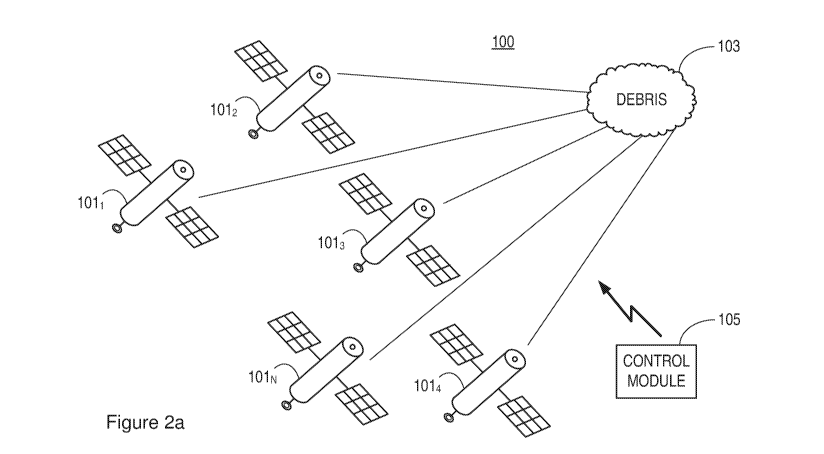
Figure 2a shows an example of a system 100 for detecting objects in space
according to a first embodiment, for example detecting an object such as space
debris or small object 103, including for example nanosatellites. The system
100 comprises an array of satellite nodes 1011 to 101N. The array of satellite
nodes comprises at least one transmitter module 107 (not shown) for
transmitting an electromagnetic signal, and a plurality of receiver modules
109
(not shown) for receiving diffractions from electromagnetic waves scattered
from objects in space. The system 100 comprises a control module 105 for
focussing the plurality of receiver modules 109 to receive diffractions from a
virtual aperture in space.
For example, one of the satellite nodes within the array, e.g. satellite node
1011,
may comprise a transmitter module 107 (not shown) for transmitting an
electromagnetic signal, while a plurality of other satellite nodes within the
array,
e.g. satellite nodes 1012 to 101N, comprise receiver modules 109 (not shown)
for detecting diffracted signals that have been scattered from any objects in
space which are located within the virtual aperture.
In another example, each satellite node 1011 to 101N may comprise a
CA 03058856 2019-10-02
WO 2018/185478 PCT/GB2018/050901
7
transmitter module, for example such that a particular satellite node 101 that
best suits a particular application or monitoring process can be selected for
transmission of the electromagnetic signal. In some embodiments, multiple
transmitter modules 107 may be activated to create multiple electromagnetic
signals, for example which are activated in a particular pattern or series. In
some examples, positive/destructive interference may be used between
sources to induce high signals in places of interest and null signals in other
places. This can be used to maximize the energy scattered by targets of
interest, or to ensure the imaging process is not detectable in other volumes
of
space (e.g. to avoid electromagnetic interference on sensitive equipment,
including third-parties, or for "stealth" imaging). The control module 105 may
therefore be configured to control a plurality of transmitter modules, for
example
to beamsteer the electromagnetic signals transmitted from the transmitter
modules.
Each satellite node 1011 to 101N may comprise a receiver module, for example
to maximise the possible number of different configurations of the plurality
of
satellite nodes that are selected to form an antenna for focussing on the
virtual
aperture, and receiving the diffracted signals. By having a receiver module
109
on each satellite node 1011 to 101N, this enables the range of different
receiver
module configurations to be maximised when the receiver modules 109 act as
separate antenna elements forming part of a larger antenna. It is noted,
however, that the invention also embraces receiver modules being located on a
sub-set of the satellite nodes 1011 to 101N.
In some examples, each satellite node 1011 to 101N comprises a transceiver
module 107/109, i.e. comprising a transmitter and receiver, such that any
satellite node within the array can transmit an electromagnetic signal,
receive
diffracted signals, or both.
The control module (105) may comprise a dynamic beamformer that is
CA 03058856 2019-10-02
WO 2018/185478 PCT/GB2018/050901
8
adaptively configured to sweep into data virtual pencil beams to form imagery
from data received from the plurality of receiver modules.
The satellite nodes 1011 to 101N of Figure 2a may be arranged in the same
orbit. However, it is noted that different satellites nodes of the array of
satellite
nodes 1011 to 101 N may be arranged in one or more different orbits.
For example, Figure 2b shows an example in which different satellite nodes
1011 to 1015 are arranged to be in different orbits.
The array of satellite nodes 1011 to 101 N of Figures 2a and 2b may be
arranged
to create two dimensional or three dimensional arrays of satellite nodes. The
arrays can also be configured to change dynamically during use.
Figure 3 shows an example of such a satellite node 101, comprising a
transmitter module 107 and a receiver module 109.
In yet another example, a satellite node 101 may comprise a plurality of
transmitter modules 107 and/or a plurality of receiver modules 109, for
example
so that a plurality of receiver modules on the same satellite node can form
part
of antenna elements for a larger antenna, or merely to provide failure back-up
for a transmitter module 107 or receiver module 109.
In view of the above, an individual satellite node 101 within the array of
satellite
nodes comprises: a transmitter module 107; or a receiver module 109; or a
transceiver module 107/109; or a plurality of transmitter modules 107 and/or
receiver modules 109.
As mentioned above, a plurality of receiver modules 109 act together to form a
larger antenna, for receiving diffracted signals which have been diffracted
from
CA 03058856 2019-10-02
WO 2018/185478 PCT/GB2018/050901
9
a target object in response to an electromagnetic signal (or series of
electromagnetic signals) which has been transmitted towards the target object.
It is noted that although the control module 105 of Figure 2a is shown as a
separate entity, the control module 105 may in fact be located on one of the
satellite nodes 1011 to 101N in the satellite array, for example a master
satellite
node. Alternatively, the functions of the control module 105 may be
distributed
among a plurality of satellite nodes within the satellite array (including for
example all of the satellite nodes). For example, individual processors may be
co-located with antenna elements on the satellite nodes. In another
embodiment, part or whole of the function of the control module 105 is located
in a ground based node, and/or in a cloud based node.
The control module 105 may be configured to control the position of a
plurality
of satellite nodes 1011 to 101m within the array of satellite nodes 1011 to
101N,
relative to one another. In one example, the relative positions of all of the
satellite nodes 1011 to 101N in the array are controlled relative to one
another.
The relative positions of the plurality of satellite nodes 1011 to 101m may be
controlled dynamically, including from within the array itself (e.g. in a self-
organised manner). This may also include the use of artificial intelligence or
neural networks with learning algorithms, as will be described later in the
application.
The relative positions may be controlled such that the control module 105 can
be configured to adaptively tune the array of satellite nodes 1011 to 101N
such
that the plurality of receiver modules 105 are focussed towards the virtual
aperture for monitoring a specific area within a larger viewing or object
field in
space.
In one embodiment, the receivers are specifically designed to be adaptive and
able to be dynamically tuned to form in their orbit locations at specific time
CA 03058856 2019-10-02
WO 2018/185478 PCT/GB2018/050901
stamps a virtual receiver aperture or lens in space such that the receiver
elements in this dynamic array can listen and in an adaptive manner be
focused, thus capturing from multi-views diffracted signals off of specific
debris
targets. The array is formed dynamically because it is operating from moving
5 satellite positions in various positions in orbit. Through high speed
array
element tracking computations the virtual aperture can focus and steer a set
of
interrogative but highly precise beams to targets via phased array signal
processing methods.
10 Each target image is formed by the totality of the energy backscattered
in the
direction and range of the corresponding beam being captured. The image
formation relies on the physics of energy propagation interacting with a
target
and is consistent with elastodynamic wave theory. The algorithm may comprise
a search-and-detect type of approach, which may be based, for example, on
Kirchhoff migration/linearized Born inversion with a detection feature.
Moreover,
in the processing of the returned signals spatial filters can be applied to
suppress the specular reflections coming off a target once captured, to allow
for
the weaker diffused energy to be better revealed. Such an embodiment can use
specific data acquisition geometry targeting back-scattering as well as
utilization
of reflection suppression/destruction filters to further accentuate the non-
specular edge/tip of targeted diffractions. Moreover, the addition of multi-
beam
multi-aspect sweeps to the data collection can help improve the likelihood of
detailed imaging and distinct separation /identification of the spatial
distribution
of the debris.
It is noted that each satellite node 1011 to 101N may also include lasers such
that their firing, alone or in particular patterns and directions, can be used
to
transfer momentum to other nodes, changing their relative position to refocus
the array or change its pattern as needed. In this way photon pressure may be
used to dynamically alter the physical configuration of the array, for example
in
case some nodes have drifted too far away after some time, or to give hard
CA 03058856 2019-10-02
WO 2018/185478 PCT/GB2018/050901
11
access to array configurations not accessible through the software options
mentioned above.
The control module 105 may be configured to control the array of satellite
nodes
1011 to 101N to sweep the virtual aperture through a larger object field, e.g.
to
try and locate or detect an object in space. In this way the receiver modules
can
be arranged to scan a large area for space debris, but obtain more detailed
information in view of the diffracted signals being gathered from a smaller
area,
i.e. the virtual aperture. Once a target object is detected, the plurality of
receiver
modules 109 can then be controlled to scan the virtual aperture over the
target
object, to obtain more information about the target object. In one example, in
order to ensure maximal success, an oversampled source and receiver array
approach is created as the antenna orbits differentially. The size of the
virtual
aperture may be changed at different times as part of its iterative
interrogation
ability. This provides the imaging method with multi-aspect transmit and
receive
arrays to better identify the character of a debris field. Then, in an
intelligently
controlled manner, neural networks and artificial intelligence can be used to
focus in on specific targets to further accentuate the debris responses, thus
providing for a unique means to establish attributes to characterize. From the
above, changing the size of the virtual aperture and the resolution cells
within
the volumes being imaged can be used to ascertain more of the scattering by
the target object, at different resolutions but also from different angles.
When sweeping a particular area of a larger object field, or sweeping over a
detected target object, the control module 105 can be adapted to sweep the
virtual aperture such that it follows a tracking pattern. Furthermore, the
control
module 105 can be adapted such that the tracking pattern takes into account
the movement or trajectory of the target object, such that the plurality of
receiver
modules 109 can be controlled to track a moving target object, which is itself
moving in relation to the plurality of receiver modules 109. For example, on
each satellite for both the transmitters and for the receivers, atomic clocks
can
CA 03058856 2019-10-02
WO 2018/185478 PCT/GB2018/050901
12
be built into their circuitry to enable synchronization in time and location
to be
precisely calculated, and tracked using tracking modelling to aid in the beam
forming from the various elements used in the beam forming, be it in the
transmission or receiving of signals. This allows for adaptive element
commands to be given to adapt the sweeping beams within this dynamic virtual
array. The tracking may be performed, for example, from a land based station
which computes in real time the exact orbital position and orbit path of each
satellite in the array (or swarm) which forms the virtual aperture, such that
the
adaptive beam forming that is created at any time stamp can be predicted and
used in the signal processing to form the debris imagery with exactitude.
When close enough to a land-based station, the atomic clocks of such a land-
based station may be used to validate and synchronise on-board clocks on the
satellite array. This can help compensate if any of the atomic clocks in orbit
start
to drift. In low orbits, on-board clocks may also be synchronised with
reference
to satellite positioning networks found below (e.g. GPS, Galileo, Glonass,
Global Navigation Satellite System, GNSS, BeiDu), who will "leak" a large
portion of their signals into space above. Further in space, self-checking of
atomic clocks by the different nodes will allow, for example through majority
voting, detection of clocks drifting from nominal accuracies, and by
comparison
between nodes, correct for trajectories or differences in data acquisition
synchronicity. Using these techniques the array of satellite nodes will have
absolute positions relative to each other, and can compare their individual
positions to a source further away (e.g. earth-based radio source or satellite
on
a smooth orbit around a particular planet). It is noted that optimization of
multiple positioning solutions may also use other techniques, such as
simulated
annealing or 4-D variability.
Thus, the embodiments described herein, having antenna arrays with adaptive
receivers, form a synthetic aperture imager that acquires distinguishing non
specular or diffused characteristic data about a debris field and particles
and
CA 03058856 2019-10-02
WO 2018/185478 PCT/GB2018/050901
13
objects contained in that debris field, which can be used to increase the
understanding of space debris or other objects in space, and which can be
used, for example, to more accurately model the position and behaviour of
orbiting space debris/objects. This has an advantage of allowing for more
effective monitoring of orbiting debris/object threats to existing orbiting
satellites.
It is noted that transmitted electromagnetic signals can be coded, for example
using amplitude, frequency and phase parameters to modulate the
electromagnetic signal, as will be familiar to a person skilled in the art.
Figures
4a, 4b and 4c show examples of different encoding schemes that may be
used. Other coding schemes may also be used, including the use of chaotic
signals, to create signals hard to distinguish from the background noise (if
eavesdropping) but amenable to target characterization (for the transmitting
party, who knows the characteristics of the chaotic signal emitted).
The received signals are processed to generate an image corresponding to
at least one point on a target object of interest, e.g. space debris. The
processing may include stacking the recordings from each receiver module
for a plurality of actuations of the source/sources, and beam steering in
response to the needs of focusing algorithms that use accurate known
location and positioning of the satellite nodes that carry the individual
receiver modules, such that at least one image point is equivalent to a focal
point of a response of the plurality of receivers associated to the debris
targets.
Because the target object is drifting, and the antenna elements (receiver
modules) are also drifting, the location of each transmitter module 107 and
receiver module 109 is registered precisely, e.g. from GPS signals, in
synchronisation with a specific time stamp.
CA 03058856 2019-10-02
WO 2018/185478 PCT/GB2018/050901
14
The control module 105 of Figure 2a may be configured to actuate the at least
one transmitter module 107 periodically, and control the plurality of receiver
modules 109 such that signals received at the plurality of receiver modules
are
indexed in time with respect to each actuation of the at least one transmitter
module 107.
The control module 105 receives time indexed signals from the plurality of
receiver modules 109, and processes the received signals to form an image of
a target object, using position information relating to the at least one
transmitter
module 107 and plurality of receiver modules 109.
Having an adaptive changing array in space with exactly located elements
when data is captured allows for the processing to beamform through a
specific antenna pattern though in flux. This allows for a parallel modelling
task to take place, which can guide the focusing routines. It can also take
into account the effects of varying element placements for carrying out the
beamforming in the data, aiding in the application of corrections. The use of
GPS/GNSS signals will cover applications within the GPS Terrestrial
Service Volume (up to 3,000 km high) and the GPS Space Service Volume
(3,000 km high to 36,000 km high), covering Low Earth Orbits to
Geosynchronous Orbits. Applications in deeper space and close to planets
and asteroids are technically possible, with a potential decrease in
resolution unless using local, bespoke positioning satellite arrays.
The dynamic sensing antenna array of the embodiments described herein
for imaging space debris is in contrast to conventional radar based methods
and to optical based Doppler interferometry, with radars typically being
applied for the characterization of debris in LEO. Conventional ground
based optical based telescopes are directed for more distant orbital region
observations such as within the geostationary ring.
CA 03058856 2019-10-02
WO 2018/185478 PCT/GB2018/050901
The beamforming according to the embodiments described herein tackles
the discrete scattering points of space debris, which tends to follow a spin
motion around their major axis. By creating a synthetic or virtual aperture
through the placement of select transmitting, i.e. transmitter module(s) 107,
5 and associated sensor elements of the antenna, i.e. receiver modules 109,
that drift, and by precisely knowing the location of each element of the
forming synthetic aperture, the resultant dynamic array, which travels along
a projected trajectory (which in some embodiments can be influenced and
guided and changed by a propulsion system resident on each of the satellite
10 nodes 101 that carries a sensor or transmitter), allows for a number of
electromagnetic pings to form an image with much higher along-track
resolution than could be considered from a stationary fixed telescope, either
ground based or in space.
15 Figure 5 shows an example of another type of satellite node 101, which
in
addition to comprising a transmitter module 107 and a receiver module 109,
further comprises a propulsion module 111 for enabling the relative position
of a satellite node 101 to be controlled within the array of satellite nodes
1011 to 101N. As mentioned earlier, in other embodiments a satellite node
101 may comprise just a transmitter module 107 and a propulsion module
111, or just a receiver module and a propulsion module 111, or a plurality of
transmitter modules 107 and/or plurality of receiver modules 109 in
combination with a propulsion module 111 (or a plurality of propulsion
modules 111).
A wide range of supporting propulsion technologies may be used as the
propulsion modules 111 for a satellite node 101 as shown in Figure 5, to
provide the need for planned on-orbit thruster motion. For example, a
propulsion module 111 may comprise a laser module as described earlier,
or a chemical propulsion module, which are characterized by low specific
impulses and high mass and power budgets, hence being primarily suitable
CA 03058856 2019-10-02
WO 2018/185478 PCT/GB2018/050901
16
for attitude control, and secondary for trajectory displacements to provide
precise orbit placement or manoeuverings of the satellite nodes forming the
array. In other examples solar sails may be used with the satellite nodes.
According to other embodiments, electric based propulsion modules 111
may be used, for example having high specific impulses, to provide
trajectory control. Ferroelectric propulsion technologies may also be used.
With their inherent scalability as plasma sources, these thrusters have an
advantage of providing small-scale thrusters to manoeuver each satellite
node forming the array. Combinations of different propulsion modules may
also be used.
Due to the nature of forming in orbit a large diameter virtual (synthetic)
aperture, the along-track resolution can approach half the length of one ping
element. The embodiments can use the drift and orbiting movement with the
aided guidance of on-board programmed propulsion modules 111 on
individual satellite nodes 101 to direct and correct, when required, the
trajectory of the receiver modules 109. The virtual aperture can then be put
to advantage to illuminate the target object through several electromagnetic
bursts. The transmitting energy can be made, for example, in the near-field
to accentuate the scattering point of each debris, whereby sub-wavelength
structures are resolved in the near field, for example within a wavelength (or
small number of wavelengths, e.g. two) of the aperture. Typically,
electromagnetic waves consist of a magnetic field and an electric field and
the characteristics of an electromagnetic field change depending on the
distance from the antenna. In one example the near field is less than one
wavelength (A) from the antenna. Wavelength in meters is given by:
A = 300 / f in MHz, with the distance from the antenna of the near field
calculated as: A/2-rr = 0.159A.
It is well explained in physics that the near field is divided into two areas,
the
reactive and the radiative. In the reactive area, the electric and magnetic
CA 03058856 2019-10-02
WO 2018/185478 PCT/GB2018/050901
17
fields are the strongest and can be measured separately. One field or the
other will dominate, which can be used by the embodiments described
herein, for example depending on different antenna types. In the radiative
area, the fields begin to radiate and this is the beginning of the far field.
In
the near field, the strength of the fields varies inversely with the cube of
the
distance from the antenna (1/r3). The transition zone refers to the area
between the near and far fields, whereby typically the far field is defined to
begin at a distance of 2A and beyond. Use of the near field allows smaller
objects or debris related scattering cells to be captured with better
resolution.
The scattering will differ on each side of the boundary between the near-
field and far-field, and some embodiments described herein can make use
of both approaches, through the use of the different nodes in the array
(transmitters, receivers and transceivers in general).
With the displacement felt within the aperture, coherent reorganization of
the received data from all the returns can lead to highly sharpened detection
and characterization of certain elements of the target object, for example
spatial coordinates that comprise:
the radial velocity of a target object;
the amplitude of a target object; and
the phases of the inherent spectral components.
Hence, the embodiments described herein utilize the independent sensor
positions of the plurality of receiver modules 109 with their accurately
verified locations at required moments in time to provide an advantage for
spatially fine-tuning and sharpening the transmission outputs, and for range
¨independent along track resolution. Synchronizing the individual receiver
modules 109 that form the sensing array with accurate individual
GPS/GNSS locations, allows for constructive phasing and shading to deliver
CA 03058856 2019-10-02
WO 2018/185478 PCT/GB2018/050901
18
narrow beam steering and sharpened beamformed responses.
In other words, the overall antenna formed by the plurality of receiver
modules 109 can be adaptively tuned to focus onto the non-specular returns
of debris. Through this approach the embodiments can repeatedly capture
profiles of a target object and monitor the character of the target object of
interest as it evolves in time.
The imagery can also be processed to evolve from a two-dimensional image
of the scattering surface to a pseudo three-dimensional rendition that
includes in its formation of the third-dimension the motions of the individual
scattering points and their distribution in space, which includes the aspect
sensitivity of the scattering, and the derived apparent-motion vectors. From
the imaging performed by the embodiments, knowledge is gained about the
targeted orbital elements and the approximate size of the object (through
the beamformed-shaded cross-section).
Energy may be focussed through a migration of the signals, depending on
the spacing of the elements and sparsity in populating the aperture. The
resulting main lobe can be sharpened to provide for the narrowest main lobe
width for a given sidelobe level, thus improving the chances for
discriminating the details or features of a target. In a similar way to
spectral
windowing in a time series analysis, array shading reduces sidelobes
resulting from sampling a finite aperture. The shading is examined and
defined related to directivity, array gain and signal-to-interference ratios,
depending upon the spacing variations and numbers of elements of the
array which form the virtual aperture at a given position in orbit and in what
orbit the satellites are travelling individually.
According to some embodiments, numerical optimizations and iterative
techniques may be used to compute a desired weighting function, for
CA 03058856 2019-10-02
WO 2018/185478 PCT/GB2018/050901
19
example because analytic solutions may not provide for an exact optimal
shading method for the virtual aperture because the satellite based aperture
is made up of irregularly spaced or non-coplanar elements similar to a
volume array.
In one example, real shading coefficients are computed for the non-uniform,
non-coplanar satellite swarm based array by resampling the optimal Dolph¨
Chebyshev window computed for a plane array at the element position of an
irregular array according to an embodiment. Because the array is in space,
there may be a degrading of the sensors used over time as elements fail,
resulting in high sidelobes. To overcome the effects of the side lobes,
shading can be used in the beam patterns associated with just the failed
elements, thus controlling the degraded array response in the sidelobe
region.
The beamforming described above allows the embodiments to steer the
beam to a particular source in 3-D space, using a multiplicity of receivers.
In
some examples all of the receivers in the array are used, while in other
examples only a subset of the receivers are used, for example if it is known
that some configurations are better at discriminating shapes and sizes of
targets. As mentioned above, the contributions from each receiver can be
weighted based on how good the signals are (e.g. amplification to
compensate for range attenuation and spreading, accounting for the
degradation of signal quality as receivers age or if they are partially masked
by debris clouds).
Since these shading coefficients are associated with non-uniform, non-
coplanar configurations, this allows for swarms to be divided into sub-
swarms, for example on different orbits or at different heights (either
because of orbital deployment constraints, or on purpose). While
conventional satellites will be on the same orbit, spaced at regular intervals
CA 03058856 2019-10-02
WO 2018/185478 PCT/GB2018/050901
along a line (e.g. such as NASA's A-train satellites), the satellites
according
to the embodiments described herein comprise more complex
configurations, which can be truly 2-D (if confined to the same altitudes) or
3-D (if using different altitudes for different parts of the array). This
multi-
5 orbit capability enable a dynamic virtual aperture to be generated, which
can
be modelled/interrogated to know where the transmit/receive elements are,
and which can be reconfigured if required by the task at hand during a
particular application.
10 This versatility in achievable configurations means that the embodiments
are not necessarily restricted to LEO or GEO.
After detection of a target object, the target object can be tracked and
observation vectors collected, from which the orbital parameters and
15 detection-scattered signature of the target object can be computed,
including for example the intrinsic rotation or tumbling rate of the target
object.
Thus, in some embodiments the control module 105 is configured to collect
20 observation vectors from the target object. The control module 105 may be
further configured to use the observation vectors to generate a target object
profile, wherein the target object profile comprises one or more of:
at least one orbital parameter of the target object;
a detection-scatter signature of the target object;
an intrinsic rotation of the target object;
a tumbling rate of the target object.
As mentioned above, the target object profile is based on a radial velocity,
amplitude and phase of the inherent spectral components of the target object.
The control module 105 can be configured to periodically update a target
object
CA 03058856 2019-10-02
WO 2018/185478 PCT/GB2018/050901
21
profile to monitor the character of the target object as it evolves in time.
This information, as gathered from the array of satellite nodes, can be fed
back to an earth based observation post to update models that aid in
mitigating uncertainties on an orbit of a specific target object of interest.
In the embodiments described above, the satellite nodes 1011 to 101N may
comprise any form of satellite. In one example, the embodiments use
miniaturized satellite technology, such as the small class of satellites
called
nano-satellites, for example the CubeSat specification. Due to their ease
of design and low costs in construction, these satellites are well placed to
support a plurality of satellites to individually hold the transmitter modules
107 and receiver modules 109 as described above.
Typically the launches of these types of satellites are in conjunction with
other payloads and are routinely accommodated as secondary or tertiary
payloads along with larger satellites or International Space Station's (ISS)
resupply missions. As such, the scheduling, and orbital placement of the
satellite nodes 1011 to 101N is readily accessible because of their small
sizes, and hence fits within the growing commercial payload launches made
available by both government funded space agencies and independent
commercial and privately funded aerospace companies.
At present the smallest form of CubeSat is approximately a 1-litre box,
10x10x11.4 cm on a side (one unit, 1U, about 1 litre in size), but there are
larger satellites available for 2U and 3U with still larger CubeSat variants
up to 6U. The mass of such a satellite is typically 1 - 10 kg. Embodiments of
the invention can therefore use nano-satellites, or CubeSat satellites, which
are readily available.
As mentioned previously, the array of satellite nodes 1011 to 101N may be
CA 03058856 2019-10-02
WO 2018/185478 PCT/GB2018/050901
22
positioned in lower earth orbit, LEO, or Geosynchronous Orbit, or intermediate
orbits between LEO and GEO, or orbits beyond GEO, or in any general orbit
around any planetary body.
Further details will now be provided in relation to the electromagnetic
measurements performed by embodiments of the invention. Unlike scalar
amplitude measurements, the embodiments make use of measurements of
the vector electromagnetic field amplitudes. The amplitudes of vector
electric and/or magnetic fields are deduced through the manipulation of the
processed beam which captures and quantifies in the restricted footprint of
the beam (i.e. the virtual aperture) voltage differences induced in the
electric
and/or magnetic antenna detectors as deployed as receiver modules 109
through the plurality of the satellite nodes forming the array placed in
orbit.
The electric and/or magnetic fields are induced in response to the electric
field and/or magnetic field imparted on the debris target by the transmission
of an electromagnetic signal from at least one transmitter module 107, and
inferences about the spatial distribution of conductivity of the target object
are made from recordings of the induced electric and/or magnetic fields
collected by the plurality of receiver modules 109.
High resolution gains are made by capturing much more subtle electric
changes through the sweeping of the antenna's receiver beams as steered
through the processing routines fully exploiting the virtual aperture and
dynamically shaped antenna array with its associated proximate tunable
broad frequency based energy sources. These sources or transmissions are
individually beam-steered with temporal stacking to achieve sufficient
signal-to-noise for the beamforming and steering to be more easily obtained
as stronger signals.
The shaped transmitted fields are obtained by a combination of geometric
CA 03058856 2019-10-02
WO 2018/185478 PCT/GB2018/050901
23
disposition of the several source current loops together with the controlled
phasing of the currents in the loops. For example, as described above in
Figure 2a, the different nodes 101 can be disposed in any geometric
configuration, whereby the node (or nodes) transmitting can be made to
emit signals with slightly different phases. The physical separations from the
emitting node (or nodes) to the target and back to the receiving nodes can
then be used to control the phasing, for example using an iterative control.
The embodiments can form as many beams as required, sweeping
particular targeted debris and/or a debris field of complex forms of differing
fragments or particulates. The resulting images and electromagnetic
attributes thus formed at a given location at a beam focusing point or area of
interest in the subject target that is being specifically illuminated may have
as many independent points as there are independent beams formed.
In some examples iterative focusing strategies are used to enhance and
improve the focusing, and thereby further the knowledge of the debris and
its orbiting environment. This may comprise, for example, illuminating
specific points or areas on the debris surface from different angles with very
high resolving strengths. The different angles will be a succession of
bistatic
angles, between the node used as transmitter (or each node used as one of
the transmitters in sequence) and the nodes used as receivers. Beam-
steering can be used in the active part (signal transmission), to illuminate
specific points or areas or volumes, and beam-forming in the passive part
(signal reception) to ensure only reflections from specific points or areas or
volumes are taken into account. The exact resolving strength can depend
on the number of nodes used (in transmission and separately in reception,
for either beam-steering or beamforming) and their separations at the time
of the measurements.
The embodiments can focus on the vector propagated fields; highlighting
CA 03058856 2019-10-02
WO 2018/185478 PCT/GB2018/050901
24
the spatial resolution and the dominance of the propagated wavefield. The
range resolutions are selected such that they are of at least in the order of
the size of target object which is being sought. Hence, the embodiments
utilize the time domain for processing. To achieve this, the embodiments
acquire and know the relative positions of all of its receivers to the same
order of accuracy as the spatial resolution that is desired to detect and
characterize. This can be achieved using, for example, the GPS/GNSS
location stamping together with the GPS/GNSS clocks that are available.
By having a transmitter module 107 that is surrounded by a plurality of
receiver modules 109, the control module 105 can derive the position
estimation from Time Difference Of Arrival (TDOA) measurements of the
signals from the transmitter module scattered back from a target object.
For enhanced accuracy, GPS clocks can be used, which allows for direct
measurement of the travel times. From this data the xyz coordinates of a
point on the target object can be obtained. By measuring at a similar interval
to the spinning/tumbling of a target object (e.g. due to the Yarkovsky
effect),
then the range resolution is better than the target size, which provides for
indications of target size and shape.
To obtain such resolutions a certain bandwidth is required. According to
some examples, the electromagnetic signal transmitted from a transmitter
module 107 is modulated with a random amplitude over a time period, which
by then cross correlated the received signal with the transmitted signal can
deliver the detection of target resolution. The selected time duration and
bandwidth set the signal-to-noise ratio, which can be chosen, for example,
to be about 30dB above the electronic noise level of a receiver module 109.
At a signal-to-noise ratio of 30dB, range resolutions greater than 10 times
that at the required Nyquist interval can be obtained, or better than a tenth
of the smallest wavelength in the transmitted sequence, giving resolutions of
CA 03058856 2019-10-02
WO 2018/185478 PCT/GB2018/050901
about 3 cm.
According to one embodiment, the spacing of the receiver modules 109 is
configured such that the time difference between received signals from a
5 target object at range R is measurable, which for example is of the order
of
about a wavelength. For example, for a range of 100km, the receiver
modules 109 can be configured to be spaced about 200m apart in the array
of receiver modules. In one example, the system exploits the near field; for
example whereby a transmitter module 107 is surrounded by a pseudo-
10 circular and/or randomized array of at least 10 receiver modules 109
over a
radius of 200m. A greater number of receiver modules can be used to
characterize the virtual aperture, which in turn improves the dynamic range.
On reception, the cross-correlation will have peaks separated in time and
15 .. corresponding to different targets. Individual peaks show a structure
coming
from the target resolvable characteristics. The duration of the transmitted
sequence will be governed by the overlaps of transmitted and received
sequences.
20 For example, referring to Figure 6 which shows received signals being
cross-correlated to identify targets (e.g. targets 1-4 in the example),
responses from different targets will have amplitudes related to the multi-
aspect scattering strength of each target. Individual peaks show a structure
coming from the target resolvable characteristics. This will include small-
25 scale variations in either the surface roughness or the intrinsic
reflectivity of
each target. These responses will last for times corresponding to the spatial
dimensions of each target across the imaging beam (this will vary as
different transmitter-receiver configurations are used, with ranges and
therefore different beamwidths at the target). The duration of the transmitted
sequence will be governed by the overlaps of transmitted and received
sequences, associated to the different ranges from transmitter(s) to the
CA 03058856 2019-10-02
WO 2018/185478 PCT/GB2018/050901
26
target and from target to receiver(s).
As can be seen from the above, the embodiments described herein provide
an antenna method and apparatus for electromagnetic imaging and
surveying which disposes a plurality of electromagnetic receivers and at least
one transmission source in a selected pattern in the orbit of the earth, that
can
help detect and better track the growing amount of debris in space, with high
location resolution and structural definition.
The antenna formed by the plurality of receivers described in the
embodiments herein utilizes an array of accurately positioned and controlled
nano-satellites to create an adaptive, dynamically positioned set of sensors
and electromagnetic transmission source/sources. The sources are
repeatedly actuated proximate to the electromagnetic receivers. Signals
generated back to the receivers, indexed in time with respect to each
actuation of at least one electromagnetic energy source, are recorded and
processed in real time by individual processors, which may be co-located for
example within the antenna elements. This convolves into discrete imagery.
The satellite constellation making up the array of satellite nodes described
above, and in turn the antenna, may be comprised of any sized satellites,
including nano-satellites. Applications beyond GEO are possible with the
same technique, albeit at lower resolution; asteroid and planetary
investigations (e.g. close to planetary asteroid belts) can be facilitated
with
the addition of bespoke positioning networks of small satellites.
According to another embodiment, there is provided a system for assessing
objects in space. The system comprises an array of satellite nodes, wherein
the
array of satellite nodes comprise at least one transmitter module for
transmitting
an electromagnetic signal, and a plurality of antenna elements for receiving
diffractions from electromagnetic waves scatted from objects in space. The
CA 03058856 2019-10-02
WO 2018/185478 PCT/GB2018/050901
27
system comprises a control module for controlling the plurality of antenna
elements to receive diffractions from a focussed virtual aperture in space. An
imaging module is configured to assess a target object based on the signals
received from the plurality of antenna elements.
According to another embodiment, there is provided an imaging system for
imaging objects in space. The imaging system comprises an array of satellite
nodes, wherein the array of satellite nodes comprise at least one transmitter
module for transmitting an electromagnetic signal, and a plurality of receiver
modules for receiving diffractions from electromagnetic waves scatted from
objects in space. The system comprises an imaging unit for generating an
image of a target object from the diffractions received at the plurality of
receiver
modules.
According to another embodiment, there is provided a system for assessing
objects in space. The system comprises an array of satellite nodes, wherein
the
array of satellite nodes comprise at least one transmitter module for
transmitting
an electromagnetic signal, and a plurality of antenna elements for receiving
diffractions from electromagnetic waves scatted from objects in space. The
system comprises a control module for controlling the plurality of antenna
elements to receive diffractions from a focussed virtual aperture in space,
and
an imaging module to assess a target object based on the signals received from
the plurality of antenna elements. The system comprises a dynamic
beamformer that is adaptively configured to sweep into data virtual pencil
beams to form imagery from received signals.
Figure 7 shows a method according to another embodiment, for detecting
objects in space using an array of satellite nodes 1011 to 101N. The method
comprises transmitting an electromagnetic signal from at least one transmitter
module in the array of satellite nodes, step 701. The method comprises
receiving diffracted signals from electromagnetic waves scattered from objects
CA 03058856 2019-10-02
WO 2018/185478 PCT/GB2018/050901
28
in space via a plurality of receiver modules 109 in the array of satellite
nodes,
step 703. The method comprises focussing the plurality of receiver modules to
receive diffractions from a virtual aperture in space, step 705, to detect an
object within the virtual aperture.
In one embodiment, a dynamic beamformer adaptively sweeps into data virtual
pencil beams to form imagery from data received from the plurality of receiver
modules.
The method may comprise controlling the position of a plurality of satellite
nodes within the array of satellite nodes, relative to one another, for
example
dynamically or adaptively. For example, the method may comprise dynamically
controlling the relative positions of the plurality of satellite nodes during
a
transmit and/or receiver operation.
The method may comprise adaptively tuning the array of satellite nodes such
that the plurality of receiver modules are focussed towards the virtual
aperture
for monitoring a specific area within a larger object field in space.
The method may comprise sweeping the virtual aperture through the larger
object field. Sweeping the virtual aperture may comprise sweeping the virtual
aperture to follow a tracking pattern. The pattern of the sweep can be
dynamically controlled in relation to image data previously received and
processed.
The method may further comprise tracking a target object that has been
detected in the virtual aperture.
In some examples the method comprises actuating the at least one transmitter
module periodically, and controlling the plurality of receiver modules such
that
signals received at the plurality of receiver modules are indexed in time with
CA 03058856 2019-10-02
WO 2018/185478 PCT/GB2018/050901
29
respect to each actuation of the at least one transmitter module.
The method may comprise receiving time indexed signals from the plurality of
receiver modules, and processing the received signals to form an image of a
target object using position information relating to the at least one
transmitter
module and plurality of receiver modules.
The method may comprise collecting observation vectors from the target object.
The observation vectors may be used to generate a target object profile,
wherein the target object profile comprises one or more of: at least one
orbital parameter of the target object; a detection-scatter signature of the
target
object; an intrinsic rotation of the target object; a tumbling rate of the
target
object. The target object profile may be based on a radial velocity, amplitude
and phase of the inherent spectral components of the target object.
According to some embodiments the method comprises controlling a propulsion
module to change the position of one or more satellite nodes of the array
relative to one or more other satellite nodes of the array, and/or to change
the
relative position of the array as a whole in relation to a target object.
Further details will now be provided in relation to an example of how the
various signals may be handled.
In one embodiment the signal processing method images the projection of a
wavelet on observed trace data using a scattering model (for example Born
approximation). The step of analyzing a wavelet may comprise incorporating
a radiation pattern (true amplitudes and phases) of scattering matrix
elements. Examples of simple radiation patterns include isotropic scattering
emphasizing non-specular returns (pure diffractions), or "Edge" diffractions
.. with 1800 phase shift (polarity reversal) orthogonal to strike direction of
fault.
CA 03058856 2019-10-02
WO 2018/185478 PCT/GB2018/050901
In contrast to conventional imaging, the image delivery according to
embodiments described herein comprises the steps of creating detailed
maps of the scattering volume in the area near-field and far-field vicinity
reached by the receiver array footprint. As such, each cell/voxel is
5 interrogated for its scattering strength (i.e. scattering cross-section)
and a
3D debris map is generated, for example based on a statistical and adaptive
beamforming processing approach.
Given that sub-wavelength scale scattering is a frequency dependent
10 phenomenon, the imaged scattering volume is implicitly frequency
dependent. Consequently, the computational domain is discretized, for
example at a minimum of 4 points per wavelength (ppw) at the highest
frequency, to allow for sufficient sampling. Other points per wavelength may
also be used.
With regard to analyzing the signals per se, known techniques may be used,
such as Green's function representation for electromagnetic fields and
waves between points. As stated in literature the causal electric field
Green's function can be obtained together with its time-reversed
counterpart. In addition, the embodiments described herein can support the
use of the electromagnetic reciprocity theorem of the time-convolution type,
which leads to the causal Green's function without constraints on the loss
mechanisms.
Once the computational grid is established, the Green function associated
with the wave equation and the implicit propagation and velocity model is
computed at each grid point. That is, each node in the discretized volume is
assumed to be an isotropic radiator/source. This stage of the processing
workflow can be handled in parallel, since computation of the Green
function at any given node is completely independent of any other node.
CA 03058856 2019-10-02
WO 2018/185478 PCT/GB2018/050901
31
The modelling for these computations can be obtained from the known
orbital time references mentioned earlier in the application, and this may be
handled, for example, on a satellite dedicated in orbit to handle the
processing and computations feeding back to a ground based observatory
as post processed responses. In such an embodiment a particular satellite
may be selected for performing the difficult data processing (for example a
larger satellite), such that the array may comprise different sized
satellites,
e.g. one larger satellite which performs such processing intensive tasks,
with an array or swarm of smaller satellites used as receivers. Another
option is to use distributed computing among an array of smaller satellites
which handle different parts of the processing (and whereby some tasks are
performed in parallel by different satellite nodes. Another option is to send
selected portions of the dataset to a land-based high-performance
computing facility, allowing for possible return of most relevant parameters
to the satellite array or swarm.
The beamformer utilized by embodiments described herein may start as a
typical phase coherent summation technique, with its operator between the
space of all recorded data. At each location of interrogation sub-volume, the
beamformer uses adaptive filters and a sum stage (as will be described
later) to interrogate predefined small volumes of space.
According to some embodiments, a dynamic artificial intelligence
beamformer may be used, which relies on a set of focussing laws, which
correct for errors in propagation path and travel time estimations. The
embodiments can employ either correlation, or eigenvalue, or maximum
power based corrections to the travel time propagation estimations (i.e.
maximal focus). Once the data from multiple aspects has been gathered, a
dynamic virtual beamformer may be configured to sweep into the data, and
create virtual pencil beams from which high-resolution imagery can be formed.
CA 03058856 2019-10-02
WO 2018/185478 PCT/GB2018/050901
32
To tackle the effect of noise on the signals, given that the signals may
encounter an interfering environment or have to deal with noisy signals in
the processing or beamforming of the signals, then linear interpolation of
discretely sampled recorded signals may be performed.
For example, a linear interpolation method may be used, that preserves the
underlying signals, and although the interpolated value departs from the
'pure signal value in proportion to the strength of the noise field, the
underlying signal amplitudes can be recovered by sufficiently stacking
beamformer voxel contribution count as the embodiments transmit and
receive multiple times, and from different orbit positions, which forms a
synthetic moving antenna pattern leading to multi-aspect views of the
target field. Hence, the embodiments can use a linear interpolation scheme
to preserve the signal content, which is recoverable against noise
interference through coherent summation.
Figure 8a shows an example of a transmission part of an embodiment,
whereby one or more satellite based transmitters 84-r, located on one or
more satellite nodes forming an array of such satellite nodes, are provided
for generating an outgoing waveform. An acquisition unit 81 provides a
trigger signal 82 to a control module 83 that is adapted to control the array
of transmitters 84-r to provide a synthetic or virtual aperture, using one or
more transmission signals 85-r that control the array comprising one or more
transmitters 84-r.
Figure 8b shows an example of a receiver part of an embodiment, whereby
one or more satellite based receivers 84R, located on one or more satellite
nodes forming an array of such satellite nodes, are provided for receiving
diffused or backscattered energy from target objects or debris. A control
module 83 is adapted to perform phased array processing of the received
signals 85R received from the array comprising one or more receivers 84R,
CA 03058856 2019-10-02
WO 2018/185478 PCT/GB2018/050901
33
to provide a signal 86 representing the detected objects or debris, which
may be used for image analysis.
The control module 83 of Figures 8a and 8b may correspond to the control
module 105 of Figure 2a, and similarly the one or more transmitters 84T
may correspond to the transmitter modules 107 mentioned in previous
embodiments, while the one or more receivers 84R may correspond to the
receiver modules 109 mentioned in previous embodiments.
Figure 8c shows a source array comprising a plurality of electromagnetic
sources 84T1-84TL which may be provided on a plurality of satellite nodes
forming part of the satellite array, and a receiver array comprising a
plurality
of receivers 84R1-84RL which may be provided on a plurality of satellite
nodes forming part of the satellite array.
Figure 9 shows an example of a method according to another embodiment.
In step 901 the model space is discretized, for example to at least 4 points
per wavelength at the highest frequency. In step 903 a Green function is
computed at each node, for example using finite-difference approximation.
This may involve the use of orbital prediction propagation and velocity
modelling, 903.
In step 904 differential target debris scattering cross-section is computed.
The optimal phase adjustments are then determined in step 905, for
example using correlation or eigenvalue methods, for maximal focus, to
update the debris detection and characteristic models.
In step 906 the detection model is updated, for example though ray based
travel time inversion, and utilization of focusing phase corrections (voxels
with sufficient scattering strength).
CA 03058856 2019-10-02
WO 2018/185478 PCT/GB2018/050901
34
The Green function is then recomputed at each node and applied to the
beamformer to obtain a final image, step 907, representing the scattering
volume (i.e. where the space debris or object is located).
The adaptive and dynamically changing smart electromagnetic signal
processing beamformer according to embodiments described herein may
comprise a multi-stage interrogating delay and filter architecture, for
example as shown in Figure 10. The first stage is the delay (tii to tim) for
each source-receiver pair that synchronizes the arrival times of a signal
scattered from the debris point at a particular location or position in orbit.
The delayed signal may be summed with filter weights being equal, thus
making the output a simple delay and sum beamformer. The beamformer
can maximize the signal in a particular direction or in a particular volume
element (voxel).
However, according to embodiments of the electromagnetic beamformer
described herein in Figure 10, the delayed signal can be multiplied by filter
weights W and then summed. The type of filter weights can be chosen or
assigned through a dynamic form of cause and effect, leading to a more
optimized beamformer to help focus on the debris field and separate and
characterize separate targets.
When the filter coefficients are defined at a particular exact time stamp
which runs through and controls the synchronization of all the satellite
based receivers and transmitters forming whatever permutation in orbit of
the antennae pattern, this results in a set of appropriately delayed times
from the delay stage, thus enabling the filter to become a customized spatial
filter.
Through the provision of artificial intelligence and neural network with
CA 03058856 2019-10-02
WO 2018/185478 PCT/GB2018/050901
learning algorithms as part of the beamformer architecture, the
embodiments can dynamically provide a responsive feedback loop with
weights in the beamformer assigned or chosen to minimize the output
power from strong specular reflections or noise outside the debris field look
5 .. direction, while maintaining the signal gain in the look direction onto
specific
debris scattering or diffractions resulting in the invention's novel evolving
electromagnetic signal based beamformer resembling a minimum variance
distortionless response filter.
10 Additional stages of filtering may be adaptively created, for example by
using constrained least mean square algorithms. The adaptiveness of the
embodiments described above creates a filter bank on each satellite
receiver, to shape both the spatial and frequency response.
15 As noted above, once the data from multiple aspects has been gathered, it
is
possible to dynamically create a virtual beamformer and sweep into the data,
creating virtual pencil beams from which high-resolution imagery can be
formed.
As such, the functionality of the dynamic beamformer can adaptively customise
the beamformer and sweep into the data virtual pencils beams, hence imagery
20 .. can be formed of the space debris or objects.
It should be noted that the above-mentioned embodiments illustrate rather than
limit the invention, and that those skilled in the art will be able to design
many
alternative embodiments without departing from the scope of the appended
25 claims. The word "comprising" does not exclude the presence of elements or
steps other than those listed in a claim, "a" or "an" does not exclude a
plurality,
and a single processor or other unit may fulfil the functions of several units
recited in the claims. Any reference signs in the claims shall not be
construed
so as to limit their scope.