Note: Descriptions are shown in the official language in which they were submitted.
,
,
A system for measuring deformations and a method for measuring
deformations
The object of the present invention is a system for measuring deformations and
a method for measuring
deformations. The system and the method are intended in particular for
measuring deformations of the
structural elements of buildings, in particular high-storage warehouses, large-
size structures, multi-
storey facilities and buildings, bridges, viaducts and roofs.
Prior art
Document US9261355B2 discloses a device for optical measurement of the
curvature of a wind power
plant rotor blade. The rotor blade is attached on a blade base to a rotor hub
or a rotor. The device
comprises at least one light-emitting external marker, attached to the rotor
blade at a certain distance
from the blade base, at least one camera attached to the rotor in order to
capture the light emitted from
the external marker. The device provides information on the first location
depending on the relative
position of the camera relative to the external marker. An assessing device is
coupled with the camera,
and the means for detecting the position detect the relative position of the
camera relative to the blade
base and provide second information on the position as a function of said
relative position. The assessing
device determines at least one variable characterising the rotor blade
curvature when assessing
information on the position.
The abovementioned solution is not used for the needs of measuring large
constructions, such as bridges
or the roofs of buildings. Additionally, it is necessary to know the position
of the camera relative to the
observed marker.
Document CN106225708A discloses an optical system for measuring susceptibility
insensitive to the
surrounding light. The general optical system for measuring susceptibility
comprises a black and white
industrial camera, a lens with a constant focal length, an electronic
theodolite, a machine for measuring
the distance, a stand, a monochromatic LED target of high brightness, a narrow
sheet of bandpass filter
corresponding to the monochromatic wavelength of the light source and a
computer. The
monochromatic LED target is installed in the tested point. An optical flex
sensor with a narrow bandpass
filter installed on the object lens is used to record the video image of the
LED target in real time. The
data is acquired in real time by means of an image-tracing algorithm based on
adjustment of the
correlation of image greyness or the extraction of characteristic points. The
overall optical system for
measuring susceptibility is insensitive to changes in the surrounding light;
it can implement a precise
1
CA 3058955 2019-10-16
measurement of displacement or elasticity during the day or night; it can
calculate numerous positions
of an object in one image and implements a dynamic measurement of displacement
or elasticity in real
time for numerous detected points.
The above solution only enables measuring the displacements of points ¨ due to
the point light source,
it is not possible to determine the rotation of the target. Apart from the
camera and the target emitting
monochromatic light, the system requires numerous additional objects, such as
filters and devices for
measuring the distance.
The summary of the invention
The object of the invention is to provide a system and a method for measuring
deformations,
free of the above-mentioned drawbacks. The system and method according to the
invention provide a
simpler system and method, which are adjusted to measuring displacements and
rotations of markers
attached to the monitored and/or examined structural elements of buildings.
The system for measuring the deformations of at least one element of at least
one examined construction
comprising at least one marker fixedly attached to an element of the examined
construction, at least one
sensor configured and programmed to record data related to the position of the
marker in the form of
digital data. Moreover, the system includes a processing unit configured and
programmed for processing
data related to the position of the marker, communicatively connected to the
sensor, preferably via a
receiving unit. The system is characterised in that the marker comprises at
least ten light-emitting
characteristic points.
Preferably, the system has light-emitting characteristic points which comprise
a point light
source or a surface light source.
Preferably, in the system, the smallest dimension of the light-emitting
characteristic points is
larger than 3 mm, preferably 5 mm, and most preferably 11 mm. Depending on the
range of work, the
dimension of characteristic points must be different, the further the marker
from the sensor, the larger
the characteristic point must be.
Preferably, in the system, the marker comprises at least fourteen
characteristic points, and more
preferably at least twenty-seven characteristic points.
Preferably, in the system, the characteristic points form an asymmetrical
shape.
Preferably, the system has a sensor provided with a surface image sensor and
an optical path,
wherein the angle between the optical axis of the optical path and a normal to
the plane defined by three
characteristic points of the marker located the closest to the sensor being
higher than 7 and lower than
75 , preferably lower than 400.
2
CA 3058955 2019-10-16
Preferably, the system comprises at least two markers having at least two
various arrangements
of characteristic points, and preferably each marker has a unique arrangement
of characteristic points,
different from the arrangement of characteristic points of the other markers.
Preferably, in the system, the characteristic points of the marker are
adjusted to being controlled,
in particular turned on and turned off, by the receiving unit or the
processing unit, which receiving unit
or processing unit is communicatively connected to the marker.
Preferably, the system has a sensor provided with an optical path with a
constant focal length.
Preferably, the system has a sensor connected to the receiving unit or the
processing unit via a
link for the transmission of data.
Preferably, the system comprises at least one receiving unit or at least one
end device, the
receiving unit and/or end device being connected to the processing unit via a
link for the transmission
of data.
The invention also comprises a method for measuring the deformations of an
examined
construction, implemented in a system comprising at least one marker fixedly
attached to an element of
the examined construction, at least one sensor configured and programmed to
record data related to the
position of the marker in the form of digital data, a processing unit
configured and programmed to
process the data related to the position of the marker, connected
communicatively to the sensor,
preferably via a receiving unit. The method comprises the steps of:
a) recording and preferably initially processing the data related to the
position of the marker by
the sensor in the form of digital data,
B) transmitting this digital data to the processing unit, preferably by means
of the receiving unit,
which preferably compresses the received digital data before transmitting it
to the processing unit.
The method is characterised in that a marker comprising at least ten light-
emitting characteristic
points is used, and by knowing the reference model of characteristic points of
the marker and knowing
the reference position of the centre of the marker and the reference rotation
of the marker,
c) rotation and position of the centre of the marker is determined by virtual
rotation and
adjustment of the reference model of characteristic points of the marker to
the digital data,
d) displacement and rotation of the marker are determined by comparing the
rotation and
position of the centre of the marker, determined in step c), with a reference
position of the centre of the
marker and a reference rotation of the marker.
Preferably, while performing the method, calibration is performed before the
first measurement,
during which, based on the recorded digital data determining the positions and
rotation of the marker,
3
CA 3058955 2019-10-16
at least one parameter describing the deformation of the image by the optical
path of the sensor is
determined, which parameter is used during the measurements to correct the
recorded digital data.
Preferably, the method is implemented in a network architecture, where the
sensor, the receiving
unit and the processing unit work in a server-client-server architecture, the
sensor and the processing
unit being the servers, and the receiving unit being the client, where the
receiving unit, based on
preliminarily determined parameters, cyclically sends out commands of
transmitting the data from at
least one sensor, and upon receiving the data transmits it to the processing
unit.
Preferably, the method is implemented where a surface image sensor provided
with an optical
path is used as the sensor, and a marker comprising at least ten
characteristic points is used, the sensor
and marker being located and set up relative to each other such that the angle
between the optical axis
of the optical path and a normal to the plane defined by three characteristic
points of the marker located
the closest to the sensor is higher than 70 and lower than 75 , preferably
lower than 40 .
Preferred embodiment of the invention
The invention will now be presented in more detail in preferred embodiments,
with reference to the
attached drawing, in which:
fig. 1 presents a flowchart of the measuring system for examining
deformations,
fig. 2 presents the flowchart of an optical sensor for examining deformations,
capable of analysing the
recorded data,
fig. 3 presents a preferable example of the orientation of the marker relative
to the optical axis of the
sensor,
fig. 4 presents an exemplary marker with visible light sources, which can be
used as characteristic points,
fig. 5 presents an exemplary marker in the form of the position of light
sources,
fig. 6 presents an exemplary virtual marker used for further steps of
determining the deformations of
the construction element,
fig. 7 presents a flowchart of an embodiment of the method according to the
invention.
The system for the measurement of deformations has been presented in two
primary embodiments. In
the first one, presented in fig. 1, the measuring system has been implemented
by means of a measuring
system in which each functional element is a separate physical element. In the
second embodiment,
presented in fig. 2, the invention has been implemented by means of an optical
sensor, in which
4
CA 3058955 2019-10-16
functional blocks are implemented as part of one device. It should be pointed
out that intermediate
solutions, which are not described herein, are also possible.
In the first embodiment, presented in fig. 1, the individual elements of the
measuring system are
separate physical elements. In this embodiment, the measuring system comprises
at least one marker 1,
whose position is recorded by at least one sensor 2. It should be pointed out
that it is also possible for
the position of two and more markers 1 to be recorded by one sensor 2. In a
preferable embodiment, one
sensor 2 observes one marker 1. The data recorded by the sensors 2 is
transmitted in the form of digital
data to the processing unit 4, which subsequently converts the data recorded
by the sensor 2 into
information involving the displacement and rotation of the marker 1. The data
from the sensor 2 can be
transmitted directly or by means of the receiving unit 3, which in this
embodiment is additionally
provided with the marker control block 7, which controls the markers 1.
In the above embodiment, the sensor 2, the receiving unit 3, the processing
unit 4 are connected to
each other by means of a local computer network 6, which simultaneously powers
these elements (the
PoE technology, Power over Ethernet). Power is provided by the power
distribution block 8.
The results of data processing can be transmitted from the processing unit 4
to the end device 5.
In another embodiment, the sensor 2, the receiving unit 3 and the processing
unit 4 work in a server-
client-server configuration, where the sensor 2 and the processing unit 4
serve the function of the server,
while the receiving unit 3 serves the functions of the client. In this
arrangement, the sensor 2 and the
processing unit 4 await information or commands from the receiving unit 3. The
sensor 2 transmits data
related to the position of the marker 1 only after receiving a proper commands
from the receiving unit
3. Upon collecting data from the sensors 2, the receiving unit 3 transfers the
collected data to the
processing unit 4. The data from the sensors 2 can be compressed by the
receiving unit 3, which allows
transmitting a smaller amount of data.
The server-client-server configuration allows the acquisition of data from
numerous sensors 2.
Furthermore, such a solution provides greater safety of the system ¨ in this
configuration, the receiving
unit 3 does not receive any instructions, which makes it more difficult to
take control over the system
remotely.
In another embodiment, the sensor 2 is connected to the receiving unit 3 or
the processing unit 4
via a link for the transmission of data.
In yet another embodiment, where the system comprises at least one receiving
unit 3 or at least one
end device 5, the receiving unit 3 and/or the end device 5 are connected to
the processing unit 4 via a
link for the transmission of data.
Fig. 2 presents an optical device for measuring the deformations of a
structural element via
observation of the marker 1 (not shown in fig. 2). The optical sensor for
determining the linear and
angular displacements comprises a sensor 2 implemented by the optical path 21,
preferably with a
constant focal length, as well as a surface image sensor 22 and a processing
unit 3, in the form of a
miniature digital computer, performing the functions of: a digital signal
conversion block 32, a data
CA 3058955 2019-10-16
compression block 33, a data transmission interface 34, a diagnostic block 35,
a remote user interface
block 31 and a power distribution block block 36. The surface image sensor 22
is connected to the
processing unit 3, in which the digital signal processing block 32 process the
acquired data. The
displacement of the object and the Euler angles determined in the digital
signal processing block 32 are
compressed in the data compressing block 33 and transmitted to the end device
5 (not shown in fig. 2),
in the form of a host computer, by means of the data transmission interface
34.
CCD, CMOS, NMOS (live MOS) matrices are examples of the surface image sensor
22. It is
possible to use any other sensor which would allow recording information
related to the position of the
marker.
It should be pointed out that the optical path 21 can be a pre-set assembly of
optical elements, such
as lenses, adjusted to a specific measurement site, but also complete object
lenses, e.g. for digital
cameras, or optical arrangements combined with a surface image sensor 22.
It should be pointed out that an option in which the miniature computer also
serves the function of
an end device 5 is also possible. In such a case, in the optical device there
is additionally an interface
enabling the display of the converted data.
In embodiments of the invention, the measurement is performed based on a
marker fixedly attached
to the examined structural element whose deformation is being measured. Fig. 4
presents an exemplary
light-emitting marker. The marker comprises LEDs which are placed in rows.
During operation, there
is a possibility to turn on the lights only for the duration of the
measurement. Such a solution allows
saving electrical energy used during the measurements, and enables easy
finding of the marker by
lighting it up, which is easy to detect by a computer. In a sample marker, it
is also possible to light up
only certain light sources, which will enable, with the same construction of
markers, obtaining unique
arrangements, which will enable unambiguous identification of the observed
markers. It should be
pointed out that the characteristic points of the marker 1 should be easily
distinguishable from the
entirety of data. This is particularly important when one sensor 2 records
data related to the position of
two and more markers 1.
In a preferable embodiment, the marker 1 receives commands related to the
lighting of
characteristic points (turning on and turning off, as well as the specific
manner of lighting) from the
receiving unit 3 or the processing unit 4. In this configuration, the marker 1
and the receiving unit 3 or
the processing unit 4 are communicatively connected to each other, preferably
wirelessly.
During later steps of the analysis, the measuring system does not deal with
individual light sources,
but their certain virtual equivalent. This is why it is preferable for the
marker to comprise characteristic
points, preferably lit up. This means that from the point of view of image
processing, the observed image
can be further analysed more easily. Such characteristic points can be
individual light sources, the
corners of an outline which creates numerous light sources, the edges or
corners of lighting areas, etc.
In addition, it is preferable for the smallest dimension of the characteristic
points to be no smaller than
11 mm. During development of the invention, it was noticed that lighting
points with a smaller diameter
6
CA 3058955 2019-10-16
prevent the performance of the measurement at distances exceeding 50 m. Due to
an increase in the size
of the lighting points, it is possible to perform the measurement at greater
distances, because the points
are easily visible for the sensor 2. In addition, during measurements at
shorter distances, a larger lighting
point facilitates the determination of its position by the larger amount of
data related to the position of
the point, received by the sensor 2, which increases the precision of
determining the position of the
characteristic points.
However, it should be pointed out that the size of the characteristic points
can be preferably smaller,
depending on the distance between the marker 1 and the sensor 2, as well as on
the used optical path 22.
In some applications, a characteristic point with a dimension of 3 mm was
recorded by the sensor 2, and
the size of the characteristic points was optimal, especially for small
distances between the sensor 2 and
the marker 1, where the distance amounts to up to about a dozen metres. For
greater distances, up to
approx. 50 m, the characteristic points were preferably larger and had a
dimension of 5 mm. For
distances greater than 50 m, the dimension of characteristic points is
preferably larger and amounts to
11 mm. It should be pointed out that the given dimensions are sample
dimensions which were used
during the development of the invention, and a person skilled in the art will
know when to use larger
and when to use smaller characteristic points.
In another embodiment, the characteristic points form an asymmetrical shape.
Due to this, it is
possible to unambiguously determine the position and rotation angles of the
marker. Additionally, in the
case of using more than one marker 1 in the measuring system, at least two
arrangements of
characteristic points are preferably used. Even more preferably, each marker
has a different arrangement
of characteristic points.
In another embodiment, the angle between the optical path 21 of the sensor 2
and a normal to the
plane defined by three characteristic points of the marker 1 located the
closest to the sensor 2 is higher
than 7 and lower than 75 , preferably lower than 400. Such orientation of the
marker 1 relative to the
sensor 2 enables reducing the errors of the measuring system. This is
associated with avoiding a position
of the marker 1 in which the Z axis of the marker 1 is directed perpendicular
relative to the plane of the
surface sensor image. In each measurement, noise causes a measurement subject
to an error of even +/-
several degrees, depending on the parameters of the system. When the angle of
inclination is small, i.e.
approx. 0 , the noise causes the read-out of both negative and positive
angles. The noise should equally
frequently overestimate as well as underestimate the results; however, with
measurements performed at
large time intervals, in the order of 30 minutes, it would be difficult to
observe the impact of noise on
the measurement due to actual deformations of the measured element. In
addition, with higher angles of
inclination of the marker 1, rotation of the marker 1 is more visible, which
is particularly significant
when using sensors 2 collecting a smaller amount of data related to the
position of the marker I.
Fig. 3 presents schematically the orientations of the marker 1 relative to the
sensor 2. The sensor
plane 2 is marked as Q, while the Z axis stands for the axis of the optical
path of the sensor 2. Coordinates
with a centre in point 0 are related to the marker 1. In a case where the
marker would be positioned
7
CA 3058955 2019-10-16
perfectly perpendicular to the optical path of the sensor 2, it would be
described using the XYZ
coordinates shown by a solid line.
It should be pointed out that the invention may also be implemented using
markers which do not
emit light. In the case of this type of markers, a round-the-clock
measurement, with no additional
lighting provided, is impossible. In addition, the embodiment presents a
solution based on visible light.
It should be pointed out that the used light spectrum is arbitrary, provided
it is possible to determine the
positions of light sources.
Fig. 4 presents an exemplary marker 1 which has twenty-seven point light
sources. Each of these
points can be turned on or turned off, which allows setting up the desired
number of characteristic points
and providing points in a proper arrangement. In an embodiment, light sources
la-1 are active, i.e. light-
emitting, and they are further recognised as characteristic points. It should
be also pointed out that all
light sources can light up, or only some of them, selected arbitrarily, which
will enable the acquisition
of sufficient data for determining the position and rotation of the marker I.
It is necessary for the marker
1 to have at least ten characteristic points, preferably at least fourteen,
and even more preferably at least
twenty-seven.
Calibration of the optoelectronic sensor (camera), as well as the subsequent
search for the values
of displacement and orientation of the object, can be performed using a marker
in the form of a
chessboard or in the form of an asymmetrical grid of circles. The embodiment
uses an asymmetrical
grid of circles, because its use provides better quality of the produced
results and provides higher
stability of the produced results during the subsequent calculating function
calls. The search for the
positions of characteristic points of a planar marker in an imaging
arrangement is implemented by
solving a Perspective N-Point-type problem, e.g. by using an iterative method
based on the Levenberg-
Marquardt optimisation and a homographic description. The homography matrix
used in this description
has a dimension of 3x3, which requires no less than four points to solve it.
It should be pointed out that
the transmission of a higher number of points favourably affects minimisation
of the reprojection error.
From the point of view of further data processing, only the position of the
centres of circles is important
in the converted image. Their number indirectly determines the number of
unknowns whose values
could be determined. In the embodiment, they are four parameters associated
with an internal matrix of
the surface image sensor (fix, fy, cx, cy) and five or more parameters related
to deformations, including
three radial parameters and two tangent parameters (a total of at least nine
parameters). On their basis,
the actual position of the marker can be determined. Assuming that N stands
for the number of
characteristic points, and K for the number of images of the marker, it can be
noticed that for N = 10
and K = 1 it is possible to determine 2*10*1= 20 limitations. Assuming a
limitation that the optical path
does not introduce any deformations, four internal parameters and six external
parameters are to be
determined. This means that in order to find a solution, one must provide such
a number of characteristic
points which fulfils the inequality 2NK > 6K+4. In a case where K = 1, the
lowest possible N which
8
CA 3058955 2019-10-16
creates the possibility of generating a regular and asymmetrical pattern
amounts to N = 10, which gives
2*10*1>6*1+4, and thus 20>10.
Fig. 5 presents reference positions of all characteristic points, which the
marker 1 may have. The
sensor 2 transmits data related to the position and orientation of the marker
1 to the processing unit 4.
Based on the reference positions of characteristic points and information on
characteristic points used
by the marker 1, the processing unit 4 determines the position of
characteristic points in the form of
coordinates. It should be pointed out that the received data related to the
position of the marker 1 requires
transformations, i.e. determining the rotation and position of the marker 1.
It should be pointed out that
when having a planar image of the marker and information on the observed
element, a person skilled in
the art can determine its spatial orientation and position by solving a
Perspective N-Point-type problem.
This issue will not be discussed in more detail in the application in
question.
After extracting from the given characteristic points their centres in the
form of coordinates, it is
possible to limit the amount of data necessary for further work. Further
limitation of the amount of data
is associated with transforming the position of characteristic points into a
virtual pattern, which is
presented in fig. 6.
The virtual pattern comprises information related to the position and rotation
of the marker 1.
Information in this form is used during further analysis. By comparing the
current virtual pattern to the
reference virtual pattern, it is possible to determine the change in the
position and orientation of the
marker 1, and as a consequence a change in the position and rotation of the
examined structural element.
In the case of first activation and configuration of the measuring system, a
reference measurement
is performed. In such a case, the first recorded data associated with the
position of the marker 1 is
considered to be reference data, in relation to which displacements and
rotations are calculated. In
addition, before the first measurement, an analysis of the optical path 21 is
performed, and deformations
introduced by the optical path 21 are determined. Upon determining the type
and intensity of
deformations, at least one parameter is determined, which would enable
correcting the data received by
the sensor 22.
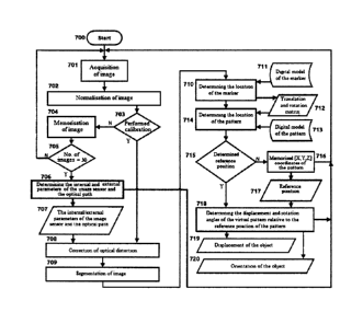
Fig. 7 presents a preferable embodiment of the method according to the
invention. Upon activating
the system, start 700, step 701 of acquiring the image by the sensor 2 takes
place. Subsequently,
normalisation of the image is performed in step 702, during which correction
of the brightness and
colours of the recorded image is performed. Subsequently, in step 703 it is
checked whether calibration
of the system has been performed. If not, then the image is stored in memory
in step 704. Subsequently,
it is checked whether a predefined number of images is stored in memory; in
the embodiment, step 705
assumes acquiring 30 images. If a lower number of images is stored in the
memory, a return to step 701
takes place. In the case of a sufficiently high number of images, in step 706
there is a determination of
internal and external sensor parameters 707 related to the sensor 2, and more
precisely to the optical
path 21 and the surface image sensor 22. Upon determination of the parameters
707, they are stored and
used during measurements.
9
CA 3058955 2019-10-16
In the case of acquiring subsequent images, step 701, knowing the parameters
707, normalisation
is performed, step 702, and upon determining that calibration has been
performed, in step 703, correction
of the optical distortion is performed, step 708.
The next step is the image segmentation step 709. In this step, elements
important from the point
of view of further data processing are extracted from the acquired data ¨
markers and characteristic
points. Subsequently, the location of the marker is determined in step 710. To
this end, data related to
the digital model of the marker 711 is collected and a Perspective N-Point
problem is solved, which
results in adjusting the marker model to the data acquired from the image and
determining the translation
matrix and the rotation matrix 712.
Subsequently, in step 714, having determined the translation matrix and the
rotation matrix 712 and
having established the digital pattern model 713, the position and orientation
of the virtual pattern are
determined on an imaging plane.
In step 715, it is checked whether a reference position has been determined.
If not, then step 716 of
memorising the coordinates and orientation of the pattern and moving to step
701 of acquiring the image
take place. If in step 715 it is determined that the reference position is
known, then step 718 of
determining for the current position and the current orientation a virtual
pattern of the displacement and
rotation angles of the virtual pattern relative to the reference position of
the pattern takes place. This
step is performed after acquiring the previously determined reference position
717. Upon determining
the displacement and orientation of the virtual pattern, and therefore the
object, a return to step 701 of
acquiring the image takes place. In step 718, memorisation of the determined
719 displacement of the
object takes place, and in step 720, the determined change in the orientation
of the object is saved.
In the embodiment, the step a) of recording and preferably initially
processing data related to the
position of the marker 1 by the sensor 2 in the form of digital data is
performed in step 701, 702, 708
and 709; step b) of transmitting digital data to the processing unit 4,
preferably by means of the receiving
unit 3, which preferably compresses the received digital data prior to sending
it to the processing unit 4,
is not shown in fig. 7 and it can take place after step 718. Steps c), where
the rotation and position of
the centre of the marker 1 are determined by virtual rotation and adjustment
of the reference model of
characteristic points of the marker 1 to the digital data and d), where the
displacement and rotation of
the marker 1 are determined by comparing the rotation and position of the
centre of the marker 1,
determined in step c), to the reference position of the centre of the marker 1
and the reference rotation
of the marker 1, are presented in more detail in steps 710 to 718.
CA 3058955 2019-10-16