Note: Descriptions are shown in the official language in which they were submitted.
1
SYSTEMS AND METHODS FOR DISPLAYING VIRTUAL RAILROAD SIGNS
CROSS-REFERENCE TO RELATED APPLICATIONS
[0001] This application claims the benefit of and priority to U.S.
Provisional Patent
Application No. 62/786,076, filed on December 28, 2018, which is hereby
incorporated by
reference herein in its entirety.
TECHNICAL FIELD
[0002] The present disclosure relates generally to railroad signs, and
more particularly, to
systems and methods for automatically displaying a plurality of virtual
railroad signs such that
a railroad vehicle can be operated without reference to physical signs placed
along the railroad
track.
BACKGROUND
[0003] Railroad vehicle operators (engineers) rely on physical signs
placed along the
railroad track to operate the railroad vehicle. For example, mileposts
indicate a location of the
railroad vehicle, whistle boards indicate when the engineer should blow the
whistle/horn, limit
signs tell the engineer where to stop at a switch to avoid collisions with
other trains, and speed
limit signs tell the engineer how fast to go. If the location of these
physical signs in changed,
or if the physical sign is removed entirely, this may inhibit the engineer's
ability to safely
operate the railroad vehicle and/or result in the railroad's non-compliance
with certain
government regulations regarding the maintenance of railroad signs. The
present disclosure is
directed to solving these and other problems.
SUMMARY
[0004] According to some implementations of the present disclosure, a
method for
operating a railroad vehicle on a railroad track without reference to physical
railroad signs
located generally along the railroad track includes determining a current
location of the railroad
vehicle along the railroad track, based on the determined current location of
the railroad
vehicle, automatically selecting a virtual railroad sign from one or more
databases containing
a plurality of virtual railroad signs, each of the plurality of virtual
railroad signs stored in the
one or more databases being associated with (i) a respective location along
the railroad track
and (ii) a respective message, and displaying, on an electronic display device
a railroad track
4844-9162-87[8 I
CA 3064385 2019-12-09
2
indicia representative of a segment of the railroad track, a railroad vehicle
indicia representative
of at least a portion of the railroad vehicle, and an indicia representative
of the associated
message of the selected virtual railroad sign.
[0005] According to some implementations of the present disclosure, a
method for
operating a railroad vehicle without reference to physical railroad signs
placed along a railroad
track includes determining a current location of the railroad vehicle along
the railroad track,
based on the determined current location of the railroad vehicle,
automatically selecting a
plurality of virtual railroad signs from one or more databases, each of the
plurality of virtual
railroad signs being associated with (i) a location along the railroad track
and (ii) a message,
and displaying, on an electronic display device a railroad track indicia
representative of a
segment of the railroad track, a railroad vehicle indicia representative of at
least a portion of
the railroad vehicle, and for each of the selected plurality of virtual
railroad signs, an indicia
representative of the associated message.
[0006] According to some implementations of the present disclosure, a
method for
operating a railroad vehicle on a railroad track without reference to physical
railroad signs
located along the railroad track includes determining a current location of
the railroad vehicle
along the railroad track, based on the determined current location of the
railroad vehicle,
automatically selecting a plurality of virtual railroad signs from one or more
databases, each of
the plurality of virtual railroad signs being associated with (i) a respective
location along the
railroad track and (ii) a respective message, and displaying, on an electronic
display device a
railroad track indicia representative of a segment of the railroad track, a
railroad vehicle indicia
representative of at least a portion of the railroad vehicle, and for each of
the selected plurality
of virtual railroad signs, an indicia representative of the associated
message.
[0007] According to some implementations of the present disclosure, a
system for
operating a railroad vehicle without reference to physical signs placed along
a railroad track
includes a GPS module configured to generate location data indicative of a
location of the
railroad vehicle on the railroad track, a memory device storing one or more
databases of virtual
railroad signs, each of the virtual railroad signs being associated with (i) a
respective location
along the railroad track and (ii) a respective message, an electronic display
device, and one or
more processors configured to determine a current location of the railroad
vehicle based on the
location data, based on the determined current location of the railroad
vehicle, automatically
select a plurality of virtual railroad signs from the database of virtual
railroad signs, the
associated location of each of the selected plurality of virtual railroad
signs being within a
predetermined distance of the current location of the railroad vehicle, and
cause the electronic
4844-9162-87181
CA 3064385 2019-12-09
3
display device to display a railroad vehicle indicia representative of at
least a portion of the
railroad vehicle, a railroad track indicia representative of a segment of the
railroad track, and
for each of the selected plurality of virtual railroad signs, an indicia
representative of the
associated message.
[0008] According to some implementations of the present disclosure a
system for
automatically displaying virtual railroad signs includes a railroad vehicle
configured to move
along a railroad track, the railroad vehicle including a Positive Train
Control (PTC) system, a
GPS module coupled to the railroad vehicle and being configured to generate
location data
indicative of a location of the railroad vehicle along the railroad track, an
electronic memory
device for storing one or more databases containing virtual railroad signs,
each of the virtual
railroad signs being associated with (i) a respective location along the
railroad track and (ii)
respective a message, an electronic display device coupled to the railroad
vehicle such that an
engineer operating the railroad vehicle can view the electronic display
device, and one or more
processors configured to determine a current location of the railroad vehicle
on the railroad
track based on location data from the GPS module, automatically select a
plurality of virtual
railroad signs from the database of virtual railroad signs, the associated
location of each of the
selected plurality of virtual railroad signs being within a predetermined
distance from the
determined current location of the railroad vehicle, and cause the electronic
display device to
display (i) a railroad vehicle indicia representative of at least a portion of
the railroad vehicle,
(ii) a first railroad track indicia representative of the first segment of the
railroad track, and (iii)
the first plurality of virtual railroad signs at corresponding locations along
the first railroad
track indicia.
[0009] The above summary is not intended to represent each embodiment or
every aspect
of the present invention. Additional features and benefits of the present
invention are apparent
from the detailed description and figures set forth below.
BRIEF DESCRIPTION OF THE DRAWINGS
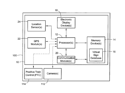
[0010] FIG. 1 is a functional block diagram of a system for automatically
displaying virtual
railroad signs and a railroad vehicle according to some implementations of the
present
disclosure;
[0011] FIG. 2A is a plan view of the railroad vehicle of FIG. 1 at a
first location along a
railroad track including a plurality of physical railroad signs according to
some
implementations of the present disclosure;
[0012] FIG. 2B is a plan view of the railroad vehicle of FIG. 1 at a
second, subsequent
4844-9162-87181
CA 3064385 2019-12-09
4
location along the railroad track of FIG. 2A according to some implementations
of the present
disclosure;
[0013] FIG. 3A illustrates an indicia representative of the railroad
vehicle, an indicia
representative of the railroad track of FIG. 2A, and a plurality of virtual
railroad signs displayed
on the electronic display device of the system of FIG. 1 according to some
implementations of
the present disclosure;
[0014] FIG. 3B illustrates an indicia representative of the railroad
vehicle, an indicia
representative of the railroad track of FIG. 2B, and a plurality of virtual
railroad signs displayed
on the electronic display device of the system of FIG. 1 according to some
implementations of
the present disclosure;
[0015] FIG. 4 is a flowchart of an example method for operating a railroad
vehicle without
reference to physical railroad signs placed along a railroad track according
to some
implementations of the present disclosure
[0016] FIG. 5 is a two-dimensional map of a railroad according to some
implementations
of the present disclosure; and
[0017] FIG. 6 is a linearized version of the two-dimensional map of the
railroad of FIG. 5
according to some implementations of the present disclosure.
[0018] While the disclosure is susceptible to various modifications and
alternative forms,
specific embodiments thereof have been shown by way of example in the drawings
and will
herein be described in detail. It should be understood, however, that it is
not intended to limit
the invention to the particular forms disclosed, but on the contrary, the
intention is to cover all
modifications, equivalents, and alternatives falling within the spirit and
scope of the invention
as defined by the appended claims.
DETAILED DESCRIPTION
[0019] Railroad vehicle operators (engineers) rely on physical signs and
signals placed
adjacent to the railroad track (e.g., subways, elevated trains, high speed
rail, monorails, trams,
etc.) to operate the railroad vehicle. Examples of physical railroad signs
include, mileposts
(indicating a reference location), whistle boards (indicating when the
engineer should blow the
horn/whistle), limit signs (indicating when the engineer should stop the
railroad vehicle at a
switch to avoid collisions with other trains), speed limit signs (indicating
how fast the engineer
can operable the railroad vehicle), curve signs (indicating an upcoming curved
or non-linear
section of the railroad track), tunnel signs (indicating an upcoming railroad
tunnel), road
crossing signs (indicating an intersecting vehicle/pedestrian roadway), rail
crossing (indicating
4844-9162-87181
CA 3064385 2019-12-09
5
an intersecting railroad track), overhead bridge sign (indicating an upcoming
overhead bridge),
grade signs (indicating a grade or incline of the railroad track), and the
like. These physical
railroad signs can be placed at various locations along the railroad track,
including, for
example, above the railroad track (e.g., an overhead sign) or on either side
of the railroad track.
100201 Many railroad vehicles (e.g., passenger trains, freight trains,
etc.) include a so-called
Positive Train Control (PTC) system. In many jurisdictions (e.g., the United
States), PTC
systems are required by government regulations. For example, all North
American freight
trains utilize PTC systems. Generally, the PTC system receives information
about the location
of the railroad vehicle (e.g., from a GPS navigation system) and information
regarding where
the railroad vehicle is allowed to safely travel. Using this information, the
PTC system prevents
or overrides unsafe movement of the railroad vehicle (e.g., reduces the speed
of the railroad
vehicle, stops the railroad vehicle, etc.) PTC systems rely on a database of
physical railroad
signs (e.g., speed limit signs) which are input into PTC algorithms to control
movement of the
railroad vehicle (e.g., enforce collision avoidance, reduce speed, etc.) In
the United States, the
Federal Railroad Administration ("FRA") requires that all PTC systems have an
accurate
database containing precise GPS coordinates of each physical railroad sign.
The total number
of physical signs in such a database may be between 400,000 and 600,000 signs.
In particular,
the FRA requires that the GPS coordinates of each sign stored in the database
are within 7.2
feet of the actual GPS coordinates of the physical sign.
100211 Railroads face several challenges continuously maintaining a
database of GPS
coordinates of physical signs within the applicable tolerances because the
physical signs are
often moved for a variety of reasons, whether intentionally or
unintentionally. For example,
railroad maintenance workers often must temporarily remove physical signs when
replacing
fouled ballast (stone material that supports the railroad track). After the
ballast is replaced,
workers place the railroad signs back in the general area of their original
position. This process
is often imprecise, meaning that the GPS coordinates stored in the PTC system
database may
no longer correspond to the new, actual GPS coordinates of the railroad sign.
As an another
example, a railroad snowplow may knock over physical signs when removing snow
from the
railroad track. Often, these signs are not repositioned until the snow is
clear (e.g., in the spring)
and is often done so in a relatively imprecise manner. As a result of this
movement of the
signs, railroads must continuously resurvey or audit the GPS coordinates of
each of the physical
signs to ensure that the PTC database is in compliance with applicable
government regulations.
Resurveying the physical signs may require personnel to travel to each of the
physical signs
and record the sign's GPS coordinates using a mobile device. Other surveying
methods may
4844-9162-8718.1
CA 3064385 2019-12-09
6
require complicated detection systems (e.g., light detection and ranging
("LIDAR") sensors
and/or simultaneous localization and mapping ("SLAM") sensors) coupled to a
railroad vehicle
to update the GPS coordinates of the physical railroad signs.
[0022] Referring to FIG. 1, a system 10 includes one or more processors 12
(hereinafter
"processor"), one or more memory devices 14 (hereinafter "memory"), one or
more electronic
display devices 18 (hereinafter "electronic display device"), a communication
module 20, a
GPS module 22, and one or more location sensors 24. The system 10 is coupled
to or located
on a railroad vehicle 100 (e.g., a locomotive, a railcar, a passenger car, a
freight car, a subway
train, a vehicle configured to move along both a conventional road surface and
railroad tracks,
etc.) As described herein, the system 10 can be used to automatically display
one or more
virtual railroad signs on the electronic display device 18 such that an
engineer can operate the
railroad vehicle without reference to physical signs placed along the railroad
track. In other
words, the physical signs places along the railroad track can be removed if
desired.
[0023] The processor 12 of the system 10 is communicatively coupled to the
memory
device 14, the electronic display device 18, the communication module 20, the
GPS module
22, and the one or more location sensors 24, and is generally used to control
the operation of
these various components of the system 10 and implement the methods described
herein. The
processor 12 can be a general or special purpose processor or microprocessor,
and the system
can include any suitable number of processors (e.g., one processor, two
processors, four
processors, ten processors, etc.)
[0024] The memory device 14 is generally used to store machine readable
instructions that
are executable by the processor 12. In particular, the memory device 14 stores
a virtual sign
database 16. The virtual sign database 16 contains an associated location
(e.g., as defined by
GPS coordinates) and associated message (e.g., a numerical speed limit) for a
plurality of
virtual railroad signs. The associated location of each of the plurality of
virtual railroad signs
is the location along the railroad track where a physical railroad sign would
be placed instead
of (or in addition to), the virtual railroad sign. Methods for generating the
virtual sign database
16 such that the virtual railroad signs contained therein correspond to where
physical railroad
signs would be positioned along the railroad track are discussed in further
detail herein. The
memory device 14 can be any suitable computer readable storage device or
media, such as, for
example, a random or serial access memory device, a hard drive, a solid state
drive, a flash
memory device, etc.
[0025] While the memory device 14 is shown as including a single virtual
sign database
16, in some implementations, the memory device 14 can include a plurality of
virtual sign
4844-9162-8718.1
CA 3064385 2019-12-09
7
databases (e.g., two databases, five databases, ten databases, etc.) For
example, a first database
can contain the associated location (e.g., GPS coordinates) of the virtual
railroad signs and a
second database can contain the associated message (e.g., numerical speed
limit) of the virtual
railroad signs. Further, while the memory device 14 of the system 10 is shown
as being coupled
to (e.g., located on) the railroad vehicle 100, alternatively, in some
implementations, the
memory device 14 can be decoupled from the railroad vehicle 100 (e.g., located
on or in a
remote device such as a remote server). In such implementations, the
communication module
20 communicatively couples the memory device 14 to the processor 12.
[0026] The
electronic display device 18 is a human-machine interface (HMI) including a
graphical user interface (GUI) that can display images (e.g., still images,
video images, or
both). As described in detail herein, the electronic display device 18 can
display, for example,
an indicia representative of a message of a virtual railroad sign, an indicia
representative of at
least a portion of the railroad vehicle 100, and/or an indicia representative
of a portion of the
railroad track. The electronic display device 18 can be, for example, a
general or special
purpose desktop computer, laptop computer, tablet computer, smartphone,
display monitor,
television, LED display, LCD display, or the like, or any combination thereof.
The electronic
display device 18 can also include an input interface such as, for example, a
touchscreen or
touch-sensitive substrate, a mouse, a keyboard, or any sensor system
configured to sense inputs
made by a human user interacting with the electronic display device 18.
[0027] As
shown, the electronic display device 18 is coupled to (e.g., located on or in)
the
railroad vehicle 100. More specifically, in some implementations, the
electronic display device
18 is located in a cab of the railroad vehicle 100 such that the electronic
display device 18 can
be viewed by an engineer operating the railroad vehicle. For
example, in some
implementations, the electronic display device 18 can be a head-up display
(HUD) that displays
image(s) without requiring the engineer to look away from the usual viewpoint
when operating
the railroad vehicle. The HUD can include a windshield projection to display
one or more
images on the windshield of the railroad vehicle 100. While the electronic
display device 18 is
shown as being coupled to (e.g., located on or in) the railroad vehicle 100,
in some
implementations, the electronic display device 18 is decoupled from the
railroad vehicle 100.
In such implementations, the electronic display device 18 can be integrated in
a mobile device
such as a smartphone, tablet, laptop computer, or the like.
[0028] The
communication module 20 is communicatively coupled to the processor 12 and
is generally used to communicate data or other information in digital or
analog form to and
from systems external to the system 10 (e.g., a remote server). Examples of
communication
4844-9162-8718.1
CA 3064385 2019-12-09
8
interfaces for the communication module 20 include a wired network interface
or a wireless
network interface. As shown, the communication module 20 of the system 10 is
coupled to the
railroad vehicle 100. Further, the communication module 20 is communicatively
coupled to
the memory device 14 via the processor 12. Thus, in some implementations, the
communication module 20 can transmit an updated or substantially real-time
virtual railroad
sign data base from a remote device to the system 10, replacing the virtual
sign database 16
previously stored in the memory device 14.
[0029] The GPS module 22 is coupled to the railroad vehicle 100 and is
configured to
receive GPS signals for determining a location (e.g., expressed in latitude
and longitude, or
other coordinates) of the railroad vehicle 100. As described herein, the
location of the railroad
vehicle 100 along a railroad track can be expressed in terms of a distance
relative to the railroad
track. Among the various railroad signs described herein are mile markers. In
other words,
the location of the railroad vehicle 100 is expressed in reference to mile
markers (e.g., the
current location of the railroad vehicle 100 is mile 5.9 of the railroad
track). To express the
location of the railroad vehicle 100 in this manner (e.g., as opposed to
purely in the form of
GPS coordinates), the processor 12 can compare the GPS coordinates determined
by the GPS
module 20 to a look-up table (e.g., stored in the memory device 14) and/or
determine a distance
between the GPS coordinates of the railroad vehicle 100 and known GPS
coordinates of the
nearest milepost.
[0030] During operation, the railroad vehicle 100 may travel in areas
(e.g., a tunnel) where
the GPS module 22 cannot acquire a GPS signal from which the location of the
railroad vehicle
100 can be determined. For this scenario, the system 10 optionally includes
one or more
location sensors 24 that are configured to determine the location of the
railroad vehicle 100
without the use of GPS signals. For example, in some implementations, the one
or more
location sensors 24 includes an optical encoder that is coupled to an end of
an axel of the
railroad vehicle 100 to detect rotational position changes. In such
implementations, the optical
encoder can be used to determine the location of the railroad vehicle 100 in
terms of a distance
traveled from an initial position (e.g., the last known location of the
railroad vehicle 100). In
other implementations, the one or more location sensors 24 includes a radio-
frequency
identification (RFID) reader coupled to the railroad vehicle 100 and being
configured to receive
location information from RFID tags positioned on or adjacent to the railroad.
The RFID tags
store information such as GPS coordinates or a distance relative to mileposts
or other
landmarks from which the system 10 can determine the location of the railroad
vehicle 100
without the use of GPS.
4844-9162-8718.1
CA 3064385 2019-12-09
9
[0031] As described herein, the railroad vehicle 100 is configured to move
along a railroad
track (e.g., railroad track 200 shown in FIGS. 2A and 2B), which can include,
for example, one
or more running rails, a power rail, crossties, fasteners, joint bars,
ballast, overhead power lines,
switches, or the like, or any combination thereof. In some implementations,
the railroad vehicle
100 includes one or more cameras 112 (hereinafter "camera") configured to
generate image
data reproducible as one or more images the railroad. The camera 112 can be a
digital camera
that generates video images, still images, or both; and can optionally include
zooming ability
(e.g., optical and/or digital zoom). As shown, the camera 112 is
communicatively coupled to
the processor 12 of the system 10. The railroad vehicle 100 also includes a
Positive Train
Control system ("FTC") 114. As described herein, the PTC system 114 is
generally used to
control the movement of the railroad vehicle 100 along the railroad track. As
shown, the FTC
system 114 is communicatively coupled to the processor 12 of the system 10. In
some
implementations, the railroad vehicle 100 can also include a light detection
and ranging
("LIDAR") sensor, a simultaneous localization and mapping ("SLAM") sensor, or
both. The
LIDAR sensor and/or SLAM sensor can be used to generate a three-dimensional
representation
of the railroad track and its surroundings, which can be stored in the memory
device 14 and/or
transmitted to a remote device via the communication module 20.
[0032] While the system 10 is shown in FIG. 1 as including all of the
components described
herein, more or fewer components can be included in a system. For example, an
alternative
system (not shown) includes the processor 12, the memory device 14, the
display device 18,
and the GPS module 22. Thus, various systems for automatically displaying
virtual railroad
signs and/or operating the railroad vehicle 100 without reference to physical
railroad signs
placed along the railroad track can be formed using any portion of the
components described
herein.
[0033] Referring to FIG. 2A, a plan view of the railroad vehicle 100 (FIG.
1) and a railroad
track 200 is illustrated. As shown, the railroad track 200 includes a
substantially linear (e.g.,
straight) section 210 and substantially non-linear (e.g., curved) section 220.
In this example,
the railroad vehicle 100 generally travels along the railroad track 200 in the
direction of arrow
A. As shown, the railroad vehicle 100 is positioned at a first location
(relative to a second,
subsequent location shown in FIG. 2B).
[0034] A plurality of physical railroad signs 230 are placed along or
adjacent to the railroad
track 200, including a plurality of milepost signs 232a-232d, a plurality of
speed limit signs
234a-234b, and a whistle board sign 236. The plurality of milepost signs 232a-
232d are
positioned along the railroad track 200 at regular intervals of one mile and
include a first
4844-9162-87181
CA 3064385 2019-12-09
10
milepost sign 232a (indicating a first mile of the railroad track 200), a
second milepost sign
232b (indicating a second mile of the railroad track 200), a third milepost
sign 232c (indicating
a third mile of the railroad track 200), a fourth milepost sign 232d
(indicating a fourth mile of
the railroad track 200), and a fifth milepost sign 232e (indicating a fifth
mile of the railroad
track 200). The plurality of speed limit signs 234a-234b includes a first
speed limit sign 234a
and a second speed limit sign 234b. As shown, the first speed limit sign 234a
is positioned at
the first mile of the railroad track 200 (e.g., at the same or similar
position as the first milepost
sign 232a). The first speed limit sign 234a communicates to the engineer
operating the railroad
vehicle 100 that the speed limit after the first milepost sign 232a is 60
miles per hour. The
second speed limit sign 234b is positioned at the fourth mile of the railroad
track 200 (e.g., at
the same or similar position as the fourth milepost sign 234b). The second
speed limit sign
234b communicates to the engineer operating the railroad vehicle 100 that the
speed limit after
the fourth milepost sign 232d is 45 miles per hour. In other words, the second
speed limit sign
234b communicates to the engineer to slow down the railroad vehicle 100 as it
is traveling on
the substantially non-linear section 220 of the railroad track 200. The
whistle board sign 236
is positioned between the first milepost sign 232a and the second milepost
sign 232b and
communicates to the engineer operating the railroad vehicle 100 to blow the
railroad vehicle
100 whistle/horn. More specifically, the whistle board sign 236 is positioned
prior to (relative
to arrow A) a crossing 250 (e.g., a rail crossing, a roadway crossing, a
pedestrian crossing, etc.)
such that the engineer blows the railroad vehicle 100 whistle/horn as a
warning that the railroad
vehicle 100 is approaching the crossing 250.
[0035] FIG. 3A illustrates an indicia 310 representative of the railroad
vehicle 100 (FIGS.
1 and 2A), an indicia 320 representative of a segment of the railroad track
200 (FIG. 2A) a
plurality of virtual railroad signs 330 corresponding to the plurality of
physical railroad signs
232 (FIG. 2A) displayed on the electronic display device 18 (FIG. 1). As
shown, the indicia
310 representative of the railroad vehicle 100 is an image or depiction of a
railroad locomotive,
although other images are possible (e.g., based on the kind of railroad
vehicle, based on the
personnel using the electronic display device 18, etc.) As shown, the indicia
320 representative
of a segment of the railroad track 200 is linear, whereas the corresponding
segment of the
railroad track 200 includes a substantially linear section 210 and a
substantially non-linear
section 220, as shown in FIG. 2A.
[0036] The electronic display device 18 also displays a current location
300 of the railroad
vehicle 100. In this example, current location 300 is expressed in terms of a
distance along the
railroad track 200 (mile 0.9), although the current location 300 can also be
expressed in other
4844-9162-8718.1
CA 3064385 2019-12-09
11
ways (e.g., in GPS coordinates). While not shown in FIG. 3A, the electronic
display device 18
can also display other information regarding the status of the railroad
vehicle 100, such as, for
example, brake pipe pressure, brake cylinder pressure, break pipe reduction,
speed,
acceleration, end-of-train status, a length of the train, or the like, or any
combination thereof.
[0037] The plurality of virtual railroad signs 330 includes a plurality of
virtual milepost
signs 332a-332e, a plurality of virtual speed limit signs 334a-334b, and a
virtual whistle board
sign 336. The plurality of virtual milepost signs 332a-332e correspond to the
plurality of
physical milepost signs 232a-232e (FIG. 2A). More specifically, a first
virtual milepost sign
332a includes an indicia 333a (in this example, the number 1) to communicate
the message of
the first virtual milepost sign 332a (e.g., the beginning of the first mile of
the railroad track
200), second virtual milepost sign 332b includes an indicia 333b (in this
example, the number
2) to communicate the message of the second virtual milepost sign 332b (e.g.,
the beginning
of the second mile of the railroad track 200), third virtual milepost sign
332c includes an indicia
333c (in this example, the number 3) to communicate the message of the third
virtual milepost
sign 332c (e.g., the beginning of the third mile of the railroad track 200),
the fourth virtual
milepost sign 332d includes an indicia 333d (e. in this example, the number 4)
to communicate
the message of the fourth virtual milepost sign 332d (e.g., the beginning of
the fourth mile of
the railroad track 200), and the fifth virtual milepost sign 332e includes an
indicia 333e (in this
example, the number 5) to communicate the message of the fifth virtual
milepost sign 332e
(e.g., the beginning of the fifth mile of the railroad track 200). As shown,
each of the plurality
of virtual milepost signs 332a-332e are spaced evenly apart on the electronic
display device 18
(FIG. 3A), just as the physical milepost signs 232a-232e are evenly spaced are
along the
railroad track 200 (FIG. 2A). As shown, each of the plurality of virtual
railroad signs 330 has
a generally square boundary in which the indicia representative of the
associated message is
contained when displayed on the electronic display device 18. While each of
the plurality of
virtual railroad signs 330 is shown as including a generally square boundary,
other boundary
shapes and sizes are possible (e.g., rectangular, circular, triangular,
polygonal, etc.)
[0038] The plurality of virtual speed limit signs 334a-334b (FIG. 3)
correspond to the
plurality of physical speed limit signs 234a-234b (FIG. 2A). A first virtual
speed limit sign
334a corresponds to the first physical speed limit sign 234a (FIG. 2A) and
includes an indicia
335a (e.g., a number) representative of the speed limit (in this example, 60
miles per hour).
Likewise, a second virtual speed limit sign 334b corresponds to the second
physical speed limit
sign 234b (FIG. 2A) and includes an indicia 335b (e.g., a number)
representative of the speed
limit (in this example, 45 miles per hour). The virtual whistle board sign 336
corresponds to
4844-9162-8718.1
CA 3064385 2019-12-09
12
the physical whistle board sign 236 (FIG. 2A) and includes an indicia 337 (in
this example, the
letter "W") communicating the message of the virtual whistle board sign 336.
[0039] As shown, the relative distances between the plurality of virtual
speed limit signs
334a-334b, the indicia 310 representative of the railroad vehicle, the
plurality of virtual
milepost signs 332a-332e, and the virtual whistle board sign 336 along the
railroad track indicia
320 correspond to the relative physical locations of the railroad vehicle 100,
the physical speed
limit signs 234a-234b, the physical milepost signs 232a-232e, and the physical
whistle board
sign 236 (FIG. 2A) along the railroad track 200.
[0040] In some implementations, the electronic display device 18 also
displays one or more
substantially real-time distances 340a-340c between the current location of
the railroad vehicle
100 and the location associated with one or more of the plurality of virtual
railroad signs 330.
In other words, the substantially real-time distance is a distance between the
location actual
railroad vehicle 100 and the location along the railroad track 200 associated
with the plurality
of virtual railroad sign 330, as if the virtual railroad sign were actually
placed along the railroad
track 200. As shown, the first virtual speed limit sign 334a includes a
substantially real-time
distance 340a between the current location 300 of the railroad vehicle and the
associated
location of the first virtual speed limit sign 334a. In this example, the
substantially real-time
distance 340a between the current location 300 of the railroad vehicle and the
first virtual speed
limit sign 334a is 0.1 miles. The virtual whistle board sign 336 includes a
substantially real-
time distance 340b between the current location 300 of the railroad vehicle
and the virtual
whistle board sign 336 which, in this example, is 0.6 miles. Similarly, the
second virtual speed
limit sign 334b includes a substantially real-time distance 340c between the
current location
300 of the railroad vehicle and the second virtual speed limit sign 334h
which, in this example,
is 3.1 miles. While not shown, it is contemplated that in some implementations
the plurality
of virtual milepost signs 332a-332e can also include a substantially real-time
distance from the
current location 300 of the railroad vehicle. As shown, each of the
substantially real-time
distances 340a-340c is positioned within the generally square boundary of the
respective one
of the plurality virtual railroad signs 330.
[0041] When operating the railroad vehicle 100 and viewing the plurality
of railroad signs
230 (FIG. 2A), an operator can only estimate how far away the railroad vehicle
100 is from the
railroad sign. If the physical railroad sign is a speed limit sign that calls
for a reduction in
speed, and if the engineer misjudges how far away the sign is (or does not see
it), this may
cause the PTC system 114 (FIG. 1) to activate and/or require the engineer to
rapidly decelerate
using the brakes. Advantageously, by displaying a substantially real-time
distance between one
4844-9162-8718.1
CA 3064385 2019-12-09
13
or more of the plurality of virtual railroad signs 330, an engineer operating
the railroad vehicle
100 can more precisely determine when to take any action (e.g., accelerate,
decelerate, etc.)
that is required by the associated message of the virtual railroad sign.
[0042] In some implementations, the electronic display device 18 can also
display a current
speed of the railroad vehicle 100. The current speed of the railroad vehicle
100 can be an
actual, measured speed of the railroad vehicle 100 (e.g., measured using the
optical encoder
described herein), an expected speed of the railroad vehicle 100 (e.g., based
on the speed limit),
or a combination of both. In such implementations, the processor 12 of the
system 10 can be
used to determine an amount of time (e.g., seconds, minutes, etc.) until the
railroad vehicle 100
reaches a location associated with one or more of the plurality of virtual
railroad signs 330. As
one example, based on the current location of the railroad vehicle 100, the
current speed of the
railroad vehicle 100, and the location associated with the second virtual
speed limit sign 334b,
the display device 18 can display an amount of time until the railroad vehicle
100 reaches the
second virtual speed limit sign 334b. For example, if the railroad vehicle 100
is traveling at 60
miles per hour, the amount of time from current location 300 to the second
virtual speed limit
sign 334b is about 18.5 seconds. In such implementations, the amount of time
can be displayed
in addition to the substantially real-time distance described herein, and can
be displayed within
the boundary of the respective one of the plurality of virtual railroad signs
330.
Advantageously, displaying an amount of time provides an engineer operating
the railroad
vehicle 100 further information to aid in operating the railroad vehicle 100
safely and
efficiently (e.g., reducing fuel consumption, allowing more gradual breaking
or acceleration,
etc.)
[0001] As described above, in some implementations, the railroad vehicle
100 includes the
camera 112, which is configured to generate image data reproducible as one or
more images of
the railroad track 200 and its surroundings. These images from the camera 112
can be
displayed on the electronic display device 18. The plurality of virtual
railroad signs 330 can
then be overlaid on these images from the camera 112 to create an augmented
reality display.
In such implementations, the plurality of virtual railroad signs 330 are
overlaid on the images
from the camera 112 such that they generally correspond to where the physical
railroad sign
230 would be located.
[0002] Referring to FIG. 2B, the railroad vehicle 100 is shown at a
second, subsequent
position (relative to FIG. 2A) as the railroad vehicle 100 has moved along the
railroad track
200 in the direction of arrow A. More specifically, after moving in the
direction of arrow A
4844-9162-8718 I
CA 3064385 2019-12-09
14
for some time, the railroad vehicle 100 has passed the first physical milepost
sign 232a and the
first physical speed limit sign 234a.
[0003] Referring now to FIG. 3B, the indicia 310 representative of the
railroad vehicle 100
(FIGS. 1 and 2A), the indicia 320 representative of a segment of the railroad
track 200 (FIG.
2B), and the plurality of virtual railroad signs 330 corresponding to the
plurality of physical
railroad signs 232 (FIG. 2B) are displayed on the electronic display device 18
(FIG. 1) when
the railroad vehicle 100 is at a second, subsequent location (relative to the
location shown in
FIG. 2A). In this example, the plurality of virtual railroad signs 330
displayed for the second,
subsequent location of the railroad vehicle (FIG. 2B) is the same as the
plurality of virtual
railroad signs 330 displayed for the first location of the railroad vehicle
100 (FIG. 2A).
[0004] As shown by a comparison of FIGS. 3A and 3B, the relative positions
of the
displayed plurality of virtual railroad signs 330 and the indicia 310
representative of the
railroad vehicle have been updated to correspond to the relative distances
between each of the
plurality of physical railroad signs 230 and the location of the railroad
vehicle 100 at the
second, sequent location (FIG. 2B). Further, the displayed current location
300 of the railroad
vehicle 100 is updated to reflect the second, subsequent location of the
railroad vehicle 100
(the railroad vehicle is now located a mile 1.4, having traveled 0.5 from the
first location (FIG.
2A) to the second, subsequent position (FIG. 2B)). Moreover, the substantially
real-time
distance 340a (FIG. 2A) between the first virtual speed limit sign 334a and
the current location
300 of the railroad vehicle 100 is removed as the railroad vehicle 100 has
already passed the
location associated with the first virtual speed limit sign 334a.
[0005] While the plurality of physical railroad signs 230 (FIGS. 2A and
2B) and the
plurality of virtual railroad signs 330 (FIGS. 3A and 3B) have been shown and
described herein
as including a plurality of milepost signs, a plurality of speed limit signs,
and a whistle board
sign, other types and combination of railroads are contemplated such as, for
example, a chain-
marker, a curve sign, a tunnel sign, a road crossing sign, a rail crossing
sign, a bridge sign, an
overhead bridge sign, a railroad sign, or any combination thereof. Further,
while the displayed
indicium of the plurality of virtual railroad signs 330 are shown and
described herein as either
a number or a letter, other types of indicium are possible, such as, for
example, a word, a
symbol, a color, an image, or the like, or any combination thereof. For
example, instead of
being a number, the displayed indicia 335a of the first virtual speed limit
sign 334a can be a
color (e.g., green), communicating to the engineer of the railroad vehicle 100
that the speed
limit is the maximum allowed speed for the railroad.
4844-9162-8718.1
CA 3064385 2019-12-09
15
[0006] In
some implementations, the system 10 can also be used to automatically display
a plurality of virtual railroad signs on the electronic display device 18.
In such
implementations, the memory device 14 stores therein a database that is
similar to the database
16 that stores a plurality of virtual railroad signs, where each of the
virtual railroad signs is
associated with a location along the railroad track and a substantially real-
time signal.
Examples of substantially real-time signals include, for example, a clear
signal (indicating that
the railroad vehicle 100 can proceed), an approach-limited signal (indicating
that the railroad
vehicle 100 can proceed at a limited speed but to be prepared to change
speeds), an approach-
medium signal (indicating that the railroad vehicle 100 can proceed at a
medium speed but to
be prepared to change speeds), a diverging-clear signal (indicating that the
railroad vehicle 100
can proceed through a diverging route), an approach signal (indicating that
the railroad vehicle
100 should proceed but prepare to stop at the next signal), a diverging-
approach signal
(indicating that the railroad vehicle 100 should proceed through a diverging
route and approach
the next signal prepared to stop), a restricting signal (indicating that the
railroad vehicle 100
should proceed at a restricted speed), a stop and proceed signal (indicating
that the railroad
vehicle 100 should stop and then proceed), a stop signal (indicating that the
railroad vehicle
100 should stop), or any combination thereof. These virtual railroad signals
can be
automatically selected from the database stored in the memory 14 and displayed
on the
electronic display device 18 using the methods described herein. For example,
in one
implementations, the memory device 14 receives, via the communication module
20, updated
information from a remote device such that each of the virtual signals stored
in the database
includes a substantially-real time signal.
[0007]
Referring to FIG. 4, a method 400 for automatically displaying one or more
virtual
railroad signs and/or for operating a railroad vehicle without reference to
physical signs placed
along the railroad track is shown. The method 400 can be implemented using the
system 10
(FIG. 1) described herein.
[0008]
Step 401 of the method 400 includes determining a current location of the
railroad
vehicle 100 along the railroad track 200 (FIGS. 2A and 2B). As described
herein, the current
location of the railroad vehicle 100 can be determined using the GPS module
22, the location
sensor(s) 24, or a combination thereof.
[0009]
Step 402 of the method 400 includes automatically selecting a plurality of
virtual
railroad signs (e.g., the plurality of virtual railroad signs 330 shown in
FIGS. 3A and 3B) from
the virtual sign database 16 of the memory device 14 (FIG. 1). As described
herein, the virtual
railroad sign database 16 stores virtual railroad signs (e.g., 100 virtual
signs, 100,000 virtual
4844-9162-87181
CA 3064385 2019-12-09
16
signs, 500,000 virtual signs, etc.), where each of the virtual railroad signs
stored therein is
associated with a location along the railroad track 200 (e.g., GPS
coordinates) and a message
(e.g., a speed limit, milepost, etc.) Automatically selecting the plurality of
virtual railroad signs
is based on the determined current location of the railroad vehicle 100. More
specifically, one
or more virtual railroad signs with associated locations that are within a
predetermined distance
from the determined current location of the railroad vehicle 100 are selected
from the virtual
sign database 16. The predetermined distance is a length of the railroad track
200 in front of
the railroad vehicle 100 in the direction of travel (arrow A). The
predetermined distance can
be, for example, between about 0.1 miles and about 100 miles, between about
0.25 miles and
about 50 miles, between about 0.5 miles and about 10 miles, between about 1
mile and about
miles, between about 3 miles and about 6 miles, about 5 miles, etc. In some
implementations, the predetermined distance can be adjusted as desired by an
engineer
operating the railroad vehicle 100 (e.g., through an input interface of the
electronic display
device 18 of the system 10) such that electronic display device 18 displays
more or less virtual
railroad signs, in greater or less detail.
[0010] Step 403 of the method 400 includes displaying an indicia
representative of at least
a portion of the railroad vehicle 100 on the electronic display device 18. In
the example shown
in FIGS. 3A and 3B, the indicia 300 representative of the railroad vehicle 100
is an image or
depiction of a railroad locomotive, although other types of indicia are
possible. For example,
the displayed indicia representative of the railroad vehicle 100 can be shape
(e.g., a rectangle),
a partial image or depiction of the railroad vehicle 100 (e.g., half of the
locomotive), or a full
or partial image or depiction of an entire rain (e.g., the locomotive and one
or more railcars).
Step 403 can also including displaying the determined current location of the
railroad vehicle
100 (step 401) on the electronic display device 18 (e.g., as shown in FIGS. 3A
and 3B).
[0011] As described herein, in some implementations, at least some of the
components of
the system 10 can be decoupled from a railroad vehicle (e.g., the electronic
display device 18).
As one example, the electronic display device 18 and other components of the
system 10 can
be integrated in a mobile device (e.g., smartphone, computer tablet, laptop,
etc.) that is carried
by a railroad maintenance worker traveling (e.g., walking) along the railroad
track 200. In such
implementations, rather than displaying an indicia representative of at least
a portion of the
railroad vehicle 100, step 403 can include displaying an indicia
representative of the
maintenance worker (e.g., a shape, a symbol, an icon, an image or depiction of
the worker, etc.)
[0012] Step 404 of the method 400 includes displaying an indicia
representative of a
portion (e.g., segment) of the railroad track 200 (FIGS. 2A and 2B) on the
electronic display
4844-9162-87181
CA 3064385 2019-12-09
17
device 18. As described above, the railroad track 200 includes a substantially
linear (e.g.,
straight) portion 210 and a substantially non-linear (e.g., curved) section
220. As shown in
FIGS. 3A and 3B, the indicia 320 representative of the railroad track 220 is
linear (e.g., a
generally straight line). Further, in some implementations, the portion of the
railroad track 220
has a length that is equal to the predetermined distance described above in
step 402 for selecting
the plurality of virtual railroad signs from the database 16.
[0013] Step 405 of the method 400 includes displaying the selected
plurality of virtual
railroad signs (step 402) on the electronic display device 18. More
specifically, step 405
includes displaying an indicia representative of the associated message of the
selected virtual
railroad signs as shown in, for example, FIGS. 3A and 3B.
[0014] Step 406 of the method 400 includes displaying a substantially real-
time distance
between the determined current location of the railroad vehicle 100 (step 401)
and the
associated locations of the selected virtual railroad signs. For example, as
shown in FIGS. 3A
and 3B, a substantially real-time distance 340a for the first virtual speed
limit sign 334a, a
substantially real-time distance 340b for the virtual whistle board sign 336,
and a substantially
real-time distance 340c for the second virtual speed limit sign 334b are
displayed on the
electronic display device 18. While the substantially real-time distances are
shown in the lower
right-hand corner of the virtual railroad signs, more generally, the
substantially real-time
distances 340a-340c can be displayed anywhere on the electronic display device
18.
[0015] Upon completion of step 406, steps 401-406 can be repeated one or
more times such
that the various images displayed on the electronic display device 18 are
continuously updated
as the railroad vehicle 100 moves along the railroad track 200. For example,
as the railroad
vehicle 100 continues to move along the railroad track 200 in the direction of
arrow A (FIGS.
2A and 2B), the current location 300 (FIGS. 3A and 3B), the positions of the
displayed plurality
of virtual railroad signs 330 relative to the indicia 310 representative of
the railroad vehicle
100 is updated, and the substantially real-time distances 340a-340c are
continuously updated.
In the examples shown in FIGS. 3A and 3B, the plurality of virtual railroad
signs 330 move
towards the indicia 310 representative of the railroad vehicle 100 as the
railroad vehicle 100
continues moves in the direction of arrow A (FIGS. 2A and 2B). Thus, all of
the various indicia
are displayed on the displayed device 18 in substantially real-time (e.g.,
with only a very small
latency on the order of milliseconds, for example).
[0016] It should be understood that when step 402 is carried out a second
time to selected
a second plurality of virtual railroad signs, the second plurality of virtual
railroad signs can be
the same as, or different than, the selected plurality of railroad signs the
first time step 402 is
4844-9162-8718.1
CA 3064385 2019-12-09
18
performed. As shown by a comparison of FIGS. 3A and 3B, the same virtual
railroad signs
330 are displayed when the railroad vehicle 100 is at the first location and
when the railroad
vehicle 100 is at the second, subsequent location. However, it should be
understood that as the
railroad vehicle 100 continues to move in the direction of arrow A, a
different plurality of
virtual railroad signs will be automatically selected from the database 16
when step 402 is
repeated.
[0017] To create the database 16 of virtual railroad signs stored in the
memory device 14,
the locations of physical railroad signs must be determined and input into the
database 16. As
described herein, the current location of the railroad vehicle 100 along the
railroad track 200 is
expressed in reference to mileposts along the railroad track 200 (e.g., the
railroad vehicle is
currently located at mile 1.4). While the locations of the physical railroad
signs can be
determined in terms of GPS coordinates, these GPS coordinates must then
correspond to a
distance along the railroad track (e.g., mile 1.0 of the railroad track). In
one example, a
geographic information system ("GIS") mapping methodology may be used to
generate the
database 16.
[0018] FIG. 5 illustrates a two-dimensional map 500 of a railroad
including a plurality of
railroad tracks. As shown, a two-dimensional first railroad track 510 includes
a plurality of
substantially linear (e.g., straight) sections 512 and a plurality
substantially non-linear (e.g.,
curved) sections 514. FIG. 6 illustrates a linearized (one-dimensional) map
600 of the railroad
shown in FIG. 5, including a linearized (one-dimensional) version 610 of the
first railroad track
510. As shown in FIG. 5, a plurality of physical railroad signs 530 are
positioned along the
two-dimensional railroad track 510. Among others, there are two methods for
mapping the
locations of the physical railroad signs 530 to the linearized version 610 of
the first railroad
track.
[0019] The first of such methods includes determining GPS coordinates of
the center of
the railroad track 510 at predefined intervals (e.g., every foot) and also
determining GPS
coordinates of the physical railroad signs 530. Based on this information, the
railroad track
510 and the plurality of physical railroad signs 530 can be mapped as the
linearized version
610 shown in FIG. 6. The second of such methods includes determining GPS
coordinates of
the physical railroad signs 530 along the two-dimensional railroad track 510
(FIG. 5) and
determining a distance between the GPS coordinates of the physical railroad
signs and railroad
mileposts to place them along the linearized version 610 of the first railroad
track shown in
FIG. 6. Of these two methods, the first method is preferred because the second
method relies
on the assumption that the mileposts are positioned correctly.
4844-9162-8718.1
CA 3064385 2019-12-09
19
100201 In accordance with the aspects described herein, in some
implementations, some or
all of the physical railroad signs 232 (FIGS. 2A and 2B) can be removed from
the railroad track
200 because the engineer can operate the railroad vehicle 100 using the
virtual railroad signs
330 displayed on the electronic display device 18 (FIGS. 3A and 3B). There are
several
advantages to removing the physical railroad signs 230. First, the railroad no
longer needs to
resurvey the GPS coordinates of physical railroad signs to ensure that the PTC
system database
is compliance with government regulations. Second, by transmitting an update
to the database
16 stored in the memory device 14, a railroad can quickly update one or more
signs (e.g., a
speed limit) without having to send workers to replace physical signs. Third,
the railroad
engineer's ability to receive messages from railroad signs is not limited by
the extent of the
engineer's visual line-of-sight, which can be limited by various factors
(e.g., inclement
weather, a curve, the terrain, etc.) Rather, the predetermined distance can be
adjusted so that
the engineer can receive messages from railroad signs that are farther ahead
of the railroad
vehicle than the engineer would be able to see. Fourth, by displaying the
linearized indicia 320
of the railroad track 200 and/or displaying substantially real-time distances
between the virtual
signs 330 and the current location of the railroad vehicle, engineers can
better anticipate what
actions need to be taken to comply with the message of the railroad signs
(e.g., speed up, slow
down, stop, etc.) The systems and methods described herein can also be used to
facilitate the
operation of autonomous railroad vehicles
[0021] While the various distances described herein are expressed in terms
of miles, more
generally, any unit of distance (e.g., feet, meters, kilometers, etc.) or any
combination of units
of distance can be used in accordance with the systems and methods described
herein.
[0022] While the present disclosure has been described with reference to
one or more
particular embodiments or implementations, those skilled in the art will
recognize that many
changes may be made thereto without departing from the spirit and scope of the
present
disclosure. Each of these embodiments or implementations and obvious
variations thereof is
contemplated as falling within the spirit and scope of the present disclosure.
It is also
contemplated that additional embodiments implementations according to aspects
of the present
disclosure may combine any number of features from any of the embodiments
described herein.
4844-9162-8718.1
CA 3064385 2019-12-09