Note: Descriptions are shown in the official language in which they were submitted.
CA 03066907 2019-12-10
WO 2018/231842 PCT/US2018/037124
ACTIVE TETHERS FOR CONTROLLING UAV FLIGHT VOLUMES,
AND ASSOCIATED METHODS AND SYSTEMS
CROSS-REFERENCE TO RELATED APPLICATION
[0001] The present application claims priority to pending US Provisional
Application
No. 62/519,089, filed June 13, 2017 and incorporated herein by reference.
TECHNICAL FIELD
[0002] The present technology is directed generally to active tethers for
controlling
flight volumes in which UAVs operate, and associated systems and methods,
including
further restraints.
BACKGROUND
[0003] Unmanned aerial vehicles (UAVs) have become increasingly popular
devices
for carrying out a wide variety of tasks that would otherwise be performed by
manned
aircraft or satellites. Such tasks include surveillance tasks, imaging tasks,
and payload
delivery tasks. However, UAVs have a number of drawbacks. For example, it can
be
difficult to operate UAVs, particularly autonomously, in close quarters, e.g.,
near buildings,
trees, or other objects. In particular, it can be difficult to prevent the
UAVs from colliding
with such objects. Accordingly, UAVs may be unable to perform the desired
surveillance
tasks in areas where potential hazards are located nearby. Therefore, there
remains a
need for techniques and associated systems that can allow UAVs to safely and
accurately
navigate within working environments that may include regions where the UAV is
to be
excluded.
BRIEF DESCRIPTION OF THE DRAWINGS
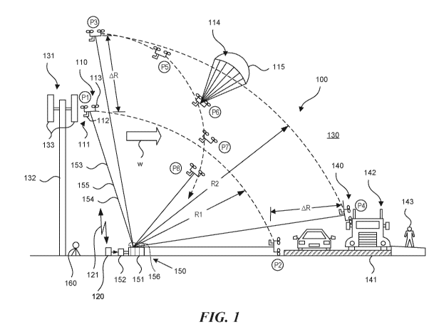
[0004] Figure 1 is a partially schematic illustration of a UAV operating
with a tether in
accordance with some embodiments of the present technology.
CA 03066907 2019-12-10
WO 2018/231842 PCT/US2018/037124
[0005] Figure 2 is a partially schematic illustration of a UAV operating
from an
elevated position using a tether in accordance with some embodiments of the
present
technology.
[0006] Figure 3 is a partially schematic illustration of a UAV gathering
information to
increase the volume of the region in which the UAV operates.
[0007] Figure 4 is a partially schematic illustration of a UAV operating
with a tether
and belay device in accordance with some embodiments of the present
technology.
[0008] Figure 5 is a flow diagram illustrating a representative method for
operating
UAVs in accordance with some embodiments of the present technology.
[0009] Figure 6 is another flow diagram illustrating representative methods
for
operating UAVs in accordance with some embodiments of the present technology.
DETAILED DESCRIPTION
[0010] The present technology is directed generally to systems and methods
for
restraining the flight of a UAV, e.g., via a tether. For example, in some
embodiments, the
tether is connected to a winch that automatically responds to an indication of
a UAV
failure, or potential failure, by rapidly reeling in the UAV. In some
embodiments, the winch
can reel in the UAV faster than the un-augmented descent rate of the UAV, even
if the
UAV has failed and is falling to the ground. This arrangement can allow the
UAV to fly in a
larger flight volume, even if hazards or other features to be avoided exist
within that flight
volume. For example, the ability to rapidly reel in the UAV in the case of a
failure can
significantly mitigate the likelihood that the UAV will strike a hazard, even
if it fails above
and/or beyond the hazard. In some embodiments, other techniques can be used in
addition to, or in lieu of, the rapidly operating winch. For example, the
tether can pass
through one or more belay devices that allow the UAV to operate in potentially
exposed
environments with only a limited range over which the UAV may travel if it
fails. In another
example, a parachute can be deployed in combination with an actively operating
winch,
with the parachute slowing the UAV's rate of descent, which can help to limit
the potential
crash radius further and preserve the aircraft.
-2-
CA 03066907 2019-12-10
WO 2018/231842 PCT/US2018/037124
[0011]
Specific details of some embodiments of the disclosed technology are
described below with reference to particular, representative configurations.
The disclosed
technology may be practiced in accordance with UAVs and associated systems
having
other configurations. And in some embodiments, particular aspects of the
disclosed
technology may be practiced in the context of autonomous vehicles other than
UAVs (e.g.,
autonomous land vehicles or watercraft).
Specific details describing structures or
processes that are well-known and often associated with UAVs, but that may
unnecessarily obscure some significant aspects of the presently disclosed
technology, are
not set forth in the following description for purposes of clarity. Moreover,
although the
following disclosure sets forth some embodiments of different aspects of the
disclosed
technology, some embodiments of the technology can have configurations and/or
components different than those described in this section. As such, the
present
technology may have some embodiments with additional elements and/or without
several
of the elements described below with reference to Figures 1-6.
[0012]
Several embodiments of the disclosed technology may take the form of
computer-executable instructions, including routines executed by a
programmable
computer or controller. Those skilled in the relevant art will appreciate that
the technology
can be practiced on computer or controller systems other than those shown and
described
below. The technology can be embodied in a special-purpose computer,
controller, or
data processor that is specifically programmed, configured, or constructed to
perform one
or more of the computer-executable instructions described below. Accordingly,
the terms
"computer" and "controller" as generally used herein include a suitable data
processor
(airborne and/or ground-based) and can include internet appliances and hand-
held
devices, including palm-top computers, wearable computers, cellular or mobile
phones,
multi-processor systems, processor-based wire programmable consumer
electronics,
network computers, laptop computers, mini-computers, and the like. Information
handled
by these computers can be presented at any suitable display medium, including
a liquid
crystal display (LCD). As is known in the art, these computers and controllers
commonly
have various processors, memories (e.g., non-transitory computer-readable
media),
input/output devices, and/or other suitable features.
-3-
CA 03066907 2019-12-10
WO 2018/231842 PCT/US2018/037124
[0013] The present technology can also be practiced in distributed
environments,
where tasks or modules are performed by remote processing devices that are
linked
through a communications network. In a distributed computing environment,
program
modules or subroutines may be located in local and remote memory storage
devices.
Aspects of the technology described below may be stored or distributed on
computer-
readable media, including magnetic or optically readable or removable computer
disks, as
well as distributed electronically over networks. Data structures and
transmissions of data
particular to aspects of the technology are also encompassed within the scope
of the
present technology.
[0014] Figure 1 is a partially schematic illustration of a system 100 that
includes a
UAV 110 operating in an environment 130. The environment 130 can include a
target 131
(e.g., a surveillance target for the UAV 110), and one or more hazards 140 or
other objects
or features to be avoided (e.g., vehicles 142 and pedestrians 143 at a roadway
141). The
overall system 100 can include a restraint system 150 configured to allow the
UAV 110 to
perform its mission at the target 131, while significantly mitigating the risk
that a failure of
the UAV 110 will cause it to collide or otherwise interfere with the hazard
140.
[0015] The UAV 110 can include a payload 111 (e.g., one or more cameras or
other
sensors 112 used to assess the target 131). The UAV 110 can further include a
propulsion system 113 that moves it into position relative to the target 131.
In some
embodiments, the target 131 can include a tower 132 carrying cellular network
antennas
133, or other structures that benefit from an inspection, servicing, and/or
other operation
performed by the UAV 110.
[0016] The restraint system 150 can include a tether 153 connected between
the
UAV 110 and a winch 151. The tether 153 can include a restraint line 154 that
is robust
enough to restrict the motion of the UAV 110 and accelerate the UAV 110 toward
the
winch 151, as will be described in further detail later. The tether 153 can
also include a
communication line 155 that provides a hardwired link between the UAV 110 and
a
controller 120. The controller 120 can also communicate with the UAV via
wireless link
121. In addition, the controller 120 can be coupled to a winch motor 152 that
drives the
winch 151, so as to control the operation of the winch 151.
-4-
CA 03066907 2019-12-10
WO 2018/231842 PCT/US2018/037124
[0017] In one mode of operation, the restraint system 150 is configured to
allow the
UAV 110 to fly at a first maximum distance or radius R1 from the winch 151.
The first
radius R1 is sufficient to allow the UAV 110 to perform at least some aspects
of its
surveillance mission from a first position P1. The first radius R1 is selected
so that if the
UAV 110 fails at any point within the hemispherical volume described by the
first radius R1
and is forced to the ground, the UAV 110 will not strike the hazard 140. For
example, if the
UAV 110 is carried toward the hazard 140 by a strong wind W or by a propulsion
or
navigation system failure, the limited first radius R1 will prevent the UAV
110 from
impacting the hazard 140, even at the closest position (P2) to the hazard 140.
[0018] In the first operation mode described above, the UAV 110 flies its
mission
while the winch 151, under the direction of the controller 120, controls the
tension on the
tether 153. Accordingly, if the UAV 110 is deliberately directed away from the
winch 151,
the controller 120 can direct the winch motor 152 to allow slack in the tether
153, up to the
first radius R1. If the UAV 110 flies toward the winch 151, the controller 120
can direct the
winch motor 152 to take up the resulting slack. In either case, the flight
path of the UAV
110 is not controlled by the tether 153, except to the extent that the maximum
paid-out
length of the tether 153 limits the maximum distance (R1) the UAV 110 can
travel.
[0019] In a second mode of operation, the restraint system 150 can be
configured to
actively control the motion of the UAV 110 (once the active restraint function
is activated),
for example in case of an emergency. In this mode, the UAV 110 can travel a
further
distance away from the winch 151 (as indicated by a second radius R2).
Accordingly, the
UAV 110 can increase its travel radius by AR compared to the first radius R1.
This in turn
allows the UAV 110 to travel to a third position P3 that allows it greater
access to the target
131. The larger second radius R2 also allows the UAV 110 to fly over the
hazard 140. To
offset or eliminate the risk of a UAV failure causing a collision with (or
otherwise interfering
with) the hazard 140, the system 100 includes provisions for actively
accelerating and/or
otherwise redirecting the UAV 110 away from the hazard 140. For example, if
the UAV
110 were to fail at the third position P3 and travel toward the hazard 140
along the second
radius R2, it would impact the hazard 140, as indicated by a fourth position
P4. In the
second mode of operation, however, the controller 120 receives an input (e.g.,
from the
-5-
CA 03066907 2019-12-10
WO 2018/231842 PCT/US2018/037124
UAV 110), indicating a failure (e.g., an actual failure, or an incipient
failure, or an upcoming
failure, or an expected or predicted failure), and responds by directing the
winch motor 152
and winch 151 to rapidly reel in the tether 153. Depending on the particular
arrangement,
the input received by the controller 120 can be a fully automated input (e.g.,
the controller
120 receives an automatically-generated input from a sensor onboard or
offboard the UAV
110), or the input can include a manual element (e.g., the controller 120
receives an input
from a user manually operating a switch). In either case, the ensuing response
initiated by
the controller 120 redirects the UAV 110 toward the winch 151 along a descent
line or path
that is more circumscribed than a circular arc with a radius of R2 (which
would intersect
the hazard 140), as indicated by descent positions P5, P6, P7 and P8. This
circumscribed
path can prevent the UAV 110 from contacting the ground any closer to the
hazard 140
than the second position P2. In some embodiments, the rapid action of the
winch 151 can
cause the UAV 110 to strike the ground at any point short of the hazard 140,
up to the
winch 151.
[0020] To achieve the foregoing effect, the winch 151 can be driven at an
acceleration and speed that not only keeps up with the slack in the tether 153
(e.g., as the
UAV 110 descends due to a failure), but that places enough tension on the
tether 153 to
accelerate the UAV 110 toward the winch 151. For example, the winch 151 can
put
sufficient tension on the UAV 110 to accelerate it downwardly to a speed
greater than the
speed with which the UAV 110 would fall in an uninhibited manner as a result
of a failure.
[0021] The UAV 110 may encounter any of a variety of possible failures that
trigger a
retraction response by the controller 120 and winch 151. For example, the
failure may
occur at one or more of the propellers, motors, electronic speed controllers,
batteries,
navigation units, and/or communication units carried by the UAV 110. A failure
can be
detected in any of a variety of suitable manners. For example, if a motor or a
propeller
fails, a suitable sensor can be used to detect an uncommanded motor speed
change. A
voltage sensor can detect a battery failure, and other sensors or algorithms
can detect a
failure in the UAV navigation and/or communication systems. In response to the
indicated
failure, the UAV 110 can send a signal via the wired communication line 155 or
the
wireless link 121, which is received by the controller 120 and which results
in the
-6-
CA 03066907 2019-12-10
WO 2018/231842 PCT/US2018/037124
accelerated winch 151 action described above. In other cases, for example, the
UAV 110
may begin traveling in a direction not authorized by either a manual operator
or by an
autonomous flight plan. In such cases, the failure corresponds to a specific
location of the
UAV 110 (e.g., an unauthorized location), which can be detected via GPS, or a
ground-
based scanner 160, or another suitable device. In any of these instances, a
corresponding
signal is sent to the controller 120, which directs the winch 151.
[0022] While the winch motor 152 and the winch 151 are configured to
rapidly
accelerate the UAV 110 toward the winch 151 in the case of a failure, such
acceleration
may not be rapid enough to avoid a collision with the hazard at all points
within the
hemispherical volume described by the second radius R2. For example, if the
UAV 110
flies autonomously or under operator control to the fourth position P4 and
then fails (the
fourth position P4 now representing a failure point), the winch 151 may not be
able to pull
the UAV 110 out of harm's way before it strikes a vehicle 142 or other element
of the
hazard 140. Accordingly, the volume within which the UAV 110 is permitted to
operate
may have a more complex shape than a simple hemisphere. For example, the
authorized
flight volume can have a decreasing radius near the hazard 140. The controller
120 can
therefore include or have access to the more complexly shaped flight volume,
and/or can
include an algorithm for determining the shape of the flight volume.
[0023] To help define the flight volume within which the UAV 110 is
authorized to
operate, the scanner 160 can be used to scan the environment 130 and identify
hazards.
Once the hazards are identified, the system 100 can automatically identify how
the flight
volume should change to account for the hazard(s), by weighting factors such
as the
maximum descent rate of the UAV 110 in case of a failure, and the maximum
acceleration
and velocity imparted to the tether 153 in response to a failure indication.
As will be
described later with reference to Figure 3, the UAV 110 itself can be used to
expand on the
information provided by the scanner 160.
[0024] In at least some embodiments, the UAV 110 can include a speed brake
114 to
slow its descent in case of a failure and thus allow more time for the winch
151 to reel it in,
which in turn enables more control over the final landing position of the UAV.
For
example, the speed brake 114 can include a parachute 115 (and/or another
suitable
-7-
CA 03066907 2019-12-10
WO 2018/231842 PCT/US2018/037124
device), which slows the descent rate of the UAV 110 and provides more time
for the
winch 151 to draw the UAV 110 inwardly away from the hazard 140. In one
embodiment,
the winch motor 152 can effectively reel in the UAV 110 so that it reliably
comes to rest in
a safe landing zone 156 directly above the winch 151 (due to the slowed
descent caused
by the speed brake 114).
[0025] In at least some embodiments, the safe landing zone 156 can be
outfitted with
protective padding, netting, or another suitable material to soften the
landing of the UAV
110. In some cases, the speed at which the winch 151 draws in the UAV 110 with
activated speed brake 114 may preserve the integrity of the aircraft. In other
cases, the
speed with which the winch 151 draws in the UAV 110 may exceed the speed
rating of the
speed brake 114 or the safe landing zone 156. In such embodiments, the speed
brake
114 can be jettisoned, or can simply be allowed to fail as the UAV 110 is
drawn inwardly
and away from the hazard 140. In some embodiments, the UAV 110 and/or the safe
landing zone 156 may be destroyed to ensure the hazard 140 is not impacted.
[0026] In some embodiments described above, the UAV 110 is positioned above
the
winch 151 to carry out its mission. In other embodiments, for example, as
illustrated in
Figure 2, the winch 151 can be positioned above the UAV 110. For example, the
target
131 can include an antenna 133 extending from a building 134, and the winch
151 can be
positioned on the roof of the building 134. The constrained environment 130
shown in
Figure 2 can include a first hazard 140a, for example an elevated train line
144 carrying
trains 145. The flight envelope for the UAV 110 can be constrained but can
still allow the
UAV 110 to overfly the hazard 140a, e.g., to provide a vantage point from
which to assess
the target 131, provided the maximum acceleration and speed of the winch 151
allow the
UAV 110 to be diverted away from the first hazard 140a. A second "hazard" 140b
can
include the target 131 itself. If the UAV 110 were to fail at some point along
a proposed
flight envelope or volume, it might swing into the antenna 133. Accordingly,
the flight
envelope can be tailored, taking into account the maximum speed of the winch
151, to
allow the UAV 110 to fly close to the antenna 133, while preserving the
ability to quickly
pull the UAV 110 upwardly and away from the antenna 133 in case of a failure.
-8-
CA 03066907 2019-12-10
WO 2018/231842 PCT/US2018/037124
[0027] Figure 3 is a partially schematic illustration of the UAV 110
operating in
another environment 330. The environment 330 can include a first hazard 340a
(e.g., a
sensitive structure) and a second hazard 340b (e.g., a building). The scanner
160 is used
to map out a permissible flight volume indicated by the second radius R2. As
discussed
above, the second radius R2 may have different values at various points within
the
volume. For example, the second radius R2 may have a greater value near the
second
hazard 340b than near the first hazard 340a.
[0028] As part of the process for mapping the environment 330, the scanner
160 can
identify known hazard surfaces, for example a first known hazard surface 346a
at the first
hazard 340a and a second known hazard surface 346b at the second hazard 340b.
Because the sensor 160 may not be able to sense the environment behind the
hazard
surfaces 346a, 346b, the environment 330 includes corresponding unknown
regions 347a,
347b. Without further information, the permissible or authorized flight
envelope or volume
will typically exclude the unknown regions 347a, 347b to avoid risk. However,
in some
embodiments, the UAV 110 itself can be used to reduce the extent of the
unknown regions
347a, 347b, thus increasing the available flight envelope for the UAV 110. For
example,
the UAV 110 can be flown to an extended radius R3, under the control of the
tether 153.
Once aloft at a ninth position P9, the UAV 110 can orient the on-board camera
112 or
other sensor to have fields of view that include portions of the unknown
regions 347a,
347b. For example, the camera 112 can have a first field of view 116a that
includes at
least a portion of the first unknown region 347a, and a second field of view
116b that
includes at least a portion of the second unknown region 347b. As a result of
the
additional information gained from the UAV 110 via the first and second fields
of view 116a
and 116b, the flight envelope can be updated to include a first updated hazard
surface
348a and corresponding first updated hazard region 349a, as well as a second
updated
hazard surface 348b and corresponding updated hazard region 349a. The UAV 110
can,
in the illustrated embodiment, identify a third hazard 340c, with
corresponding third
updated hazard surfaces 348c. Aside from the updated hazard surfaces 348, the
remaining portions of the initially unknown regions 347a, 347b are now known,
and the
flight envelope can accordingly be extended into these regions, with the
tether 153
operating to retract the UAV 110 from these regions in case of a UAV failure.
-9-
CA 03066907 2019-12-10
WO 2018/231842 PCT/US2018/037124
[0029] Figure 4 is a partially schematic illustration of a restraint system
150 that
operates in accordance with some embodiments of the present technology. The
restraint
system 150 can include a winch 151, winch motor 152, tether 153, and
controller 120 that
operate in a manner generally similar to that described above with reference
to Figures
1-3. In a first mode of operation, the tether 153 can have a first radius R1
that allows the
UAV 110 to operate without the need for an accelerated reel-back operation to
avoid a
corresponding hazard 140 (in this example, a power substation 439).
Accordingly, the
UAV 110 can ascend to a tenth position P10 along the first radius R1. In a
second mode
of operation, the tether 153 extends to a second radius R2, which means the
UAV 110 can
fly over the hazard 140, with the winch 151 operable in the manner described
above to
prevent contact between the UAV 110 and the hazard 140 in the event of a UAV
failure.
[0030] In a third mode of operation, the tether 153 can pass through a
belay device
457 positioned at a belay point 456 to further restrain the motion of the UAV
110 in the
event of a failure. In particular, if the UAV 110 fails while at an eleventh
position P11, its
motion is constrained by the belay device 457 to prevent contact with the
hazard 140.
Instead, the UAV 110 can remain suspended from the belay point 456 by the
tether 153.
The belay device 457 can suspend the UAV 110, whether or not the winch 151 is
also
operated in an accelerated manner. Accordingly, the belay device 457 can be
used either
alone or in conjunction with the accelerated reel operation described above.
[0031] In a particular embodiment, the target 131 to which the UAV is
directed
includes a tower 132 carrying one or more antennae 133, and the belay point
456 can be
located at the tower 132. In other embodiments, the belay point 456 can have
other
locations. In some embodiments, the belay device 457 can be placed in position
by a
human operator, or by the UAV 110. For example, the belay device 457 can have
an
electromagnetic actuator that attaches it to the tower 132. After use, the
electromagnet
can be remotely deactivated so that the belay device 457 can be returned to
the ground for
later use. Another electromagnet can be coupled to a gate of the belay device
457 to
selectively engage with and disengage from the tether 153. In other
embodiments, the
belay device 457 can be permanently fixed in the environment and available for
attachment. In yet another embodiment, the belay point 456 can be created by
the UAV
-10-
CA 03066907 2019-12-10
WO 2018/231842 PCT/US2018/037124
110 without the need for a belay device 457. For example, the UAV 110 can fly
several
times around the tower 132, wrapping the tether 153 tightly around the belay
point 456.
[0032] As discussed above, systems configured in accordance with the
present
technology can be operated in a variety of suitable manners to limit or
constrain the
regions in which a UAV 110 flies, so as to reduce or minimize the risk of a
collision
between the UAV 110 and objects in its environment 130, in the event of a UAV
failure. As
shown in Figure 5, a representative method 500 includes planning or
identifying a flight
region (block 501), flying a UAV under tethered (and/or other) constraint
within the flight
region (block 510) and manipulating the tether to constrain emergency landing
or impact
sites (block 520). Any of the foregoing tasks can be performed independently
of the
others, and/or can include one or more subprocesses, as described below with
reference
to Figure 6.
[0033] Figure 6 illustrates specific details of several of the processes or
steps
described above with reference to Figure 5, suitable for some embodiments of
the present
technology. Generally, a representative process 600 includes a planning phase
(block
601), a flight stage (block 610) and a termination phase (block 620). Each of
the foregoing
phases can include one or more associated steps or processes. For example, the
planning phase 601 can include building a representation of the environment
within which
the UAV operates. The representation can have a number of suitable
configurations,
including a two-dimensional representation or a three-dimensional
representation. The
representation can be obtained from the scanner 160 described above with
reference to
Figures 1 and 3, alone or with additional inputs. For example, Google Maps or
another
preexisting database can be used as an initial representation, and can be
updated, as
necessary, with data obtained more recently via the scanner 160 or other
suitable device.
[0034] At block 603, the process includes determining or identifying
specific areas for
the UAV 110 to avoid (e.g., hazards). Such areas may be safety-critical and/or
have other
reasons for being restricted. In some embodiments, such areas are selected by
the
operator (e.g., using a 2-D map or a 3-D representation), and in some
embodiments the
areas can be automatically determined, for example by using appropriate
optical
-11-
CA 03066907 2019-12-10
WO 2018/231842 PCT/US2018/037124
recognition techniques, databases, and/or other techniques. The areas can be
generally
flat (e.g., roads) or can have more 3-D shapes (e.g., buildings).
[0035] Based on the initial representation of the environment and the
specified areas
to be avoided, the process can further include determining authorized flight
volumes (block
604). This process can include combining an initial unrestricted volume with
volumes that
have been identified as safety-critical or otherwise sensitive. To determine
the extent of
the ultimately restricted areas, the process can include accounting for where
the winch is
located, which in turn determines the envelope of suitable tether orientations
and radii.
The orientation and radius of the tether can in turn determine the time
required to withdraw
the UAV in the case of a failure. Other factors include, but are not limited
to, the proximity
of the restricted areas to safe landing areas, the length of the tether at
various elevations
or altitudes, the tether retraction rate, the weight of the UAV, wind speeds,
whether or not
a speed brake is used and, if used, at what rate the speed brake deploys. The
result can
include a volume within which the UAV is expected to fly safely, and within
which the UAV
can avoid hazards, even in the case of a UAV failure.
[0036] Block 605 includes planning a flight path within the authorized
flight volume
established above. In some embodiments, the user can create the flight path,
with
constraints provided by the system. In other embodiments, an algorithm can
build the
flight path, also taking into account the constraints. In still further
embodiments, block 605
can be eliminated and the operator can fly without a flight plan while in the
authorized flight
volume. To prevent incidental or accidental contact with hazards, and/or
flying into unsafe
areas, the system can automatically constrain the flight of the UAV, via the
tether, to avoid
such areas.
[0037] Block 610 (flying the UAV) can include normal flight operations
(block 611).
As part of the normal flight operations, the system can repeatedly check one
or more
safety indications. For example, at block 612, the system can determine
whether the UAV
is within the authorized flight volume (e.g., a safe-state space) defined
above. This
process can include checking the position, velocity, and/or acceleration of
the UAV in
accordance with a preset schedule (e.g., multiple times per second). If it is,
the loop
continues to iterate. If not, the process passes to the termination phase 620.
In addition to
-12-
CA 03066907 2019-12-10
WO 2018/231842 PCT/US2018/037124
(e.g., in parallel with) determining whether the system is operating in the
authorized flight
volume, the process can include determining whether the flight systems are
healthy (block
613). Representative systems include sensors, actuators, and/or estimators. If
so, the
loop reiterates, and if not, the process proceeds to the termination phase
620.
[0038] The termination phase 620 can include initiating active recovery by
retracting
the tether to reduce the flight radius available to the UAV and thereby
prevent the UAV
from contacting hazards or unsafe areas (block 621). For example, as discussed
above, in
response to an indication of a failure or imminent failure, the system can
immediately
accelerate the UAV, via the tether, toward the winch. In some embodiments, the
system
can attempt to limit damage to the UAV, for example by repeatedly attempting
to restart
the UAV or otherwise reduce the impact force of the UAV. In any of the
foregoing
embodiments, it is generally expected that damage to the UAV, while
undesirable, is less
undesirable than damage to the hazard that the UAV is being kept away from.
Accordingly, in a typical operation, priority is given to extracting the UAV
from what would
otherwise be close proximity to a hazard. Optionally, the process can include
deploying a
speed brake (e.g., a parachute) to show the UAV descent rate and further
reduce the
contact radius (block 622).
[0039] One feature of some of the embodiments described above is that the
tether
can allow a UAV to fly within regions from which it would otherwise be
excluded. In
particular, the tether can be coupled to a winch that responds quickly enough,
and
accelerates the tether quickly enough, to remove the UAV from a potentially
hazardous
area, in the event of a failure of the UAV, before the UAV contacts sensitive
structures
and/or otherwise interferes with devices or people in the hazardous area.
Accordingly,
such embodiments can improve the working range of the UAV without
unnecessarily
increasing associated risks.
Additional Examples
[0040] Several aspects of the present technology are set forth in the
following
examples.
-13-
CA 03066907 2019-12-10
WO 2018/231842 PCT/US2018/037124
1. A method for operating a UAV, comprising:
receiving an indication of a UAV failure or predicted failure while the UAV is
aloft;
and
in response to the indication, applying an acceleration to the UAV via a
tether
attached to the UAV.
2. The method of example 1 or example 2, further comprising:
directing the UAV upwardly from a launch site prior to receiving the
indication.
3. The method of any of examples 1-3, further comprising deploying a brake
from the UAV.
4. The method of example 3 wherein the brake includes a parachute.
5. The method of any of examples 1-4 wherein the indication is a first
indication
and wherein the method further comprises:
receiving a second indication of a flight volume; and
in response to the indication, controlling a deployed length of the tether to
keep the
UAV within the flight volume.
6. The method of example 5, further comprising using data obtained via the
UAV to define, at least in part, the flight volume.
7. The method of example 5 wherein tether is a portion of a restraint
system,
the restraint system further including a winch, and wherein the flight volume
has a spatially
varying radius from the winch.
8. The method of any of examples 1-7, further comprising coupling the
tether to
a belay device.
-14-
CA 03066907 2019-12-10
WO 2018/231842 PCT/US2018/037124
9. The method of any of examples 1-8, further comprising ending flight of
the
UAV in response to the indication.
10. The method of example 9 wherein ending the flight includes damaging the
UAV.
11. The method of any of examples 1-10 wherein applying an acceleration to
the
UAV includes winching the tether.
12. The method of any of examples 1-11 wherein applying an acceleration to
the
UAV includes applying an upward acceleration to the tether.
13. The method of any of examples 1-11 wherein applying an acceleration to
the
UAV includes applying a downward acceleration to the tether.
14. A method for operating a UAV, comprising:
connecting a tether line between the UAV and a motorized winch;
directing the UAV upwardly from a launch site while paying out the winch line
from
the motorized winch;
directing the UAV along a flight path that includes a failure point, wherein a
descent
line of the UAV from the failure point intersects a target to be avoided;
while the UAV is at the failure point, receiving an indication of a UAV
failure or
predicted failure;
in response to the indication, applying an acceleration to the UAV via the
tether line
in a direction toward the launch site; and
directing the UAV to the ground via the tether, while avoiding contact between
the
UAV and the target via tension provided by the tether.
15. The method of example 14 wherein directing the UAV to the ground
includes
cushioning an impact of the UAV with the ground.
-15-
CA 03066907 2019-12-10
WO 2018/231842 PCT/US2018/037124
16. The method of any of examples 14-15 wherein applying the acceleration
to
the UAV includes applying the acceleration in a direction aligned along the
tether.
17. A method for operating a UAV, comprising:
mapping a flight volume for the UAV with a ground-based scanner, wherein the
flight volume excludes a hazard;
connecting a tether line between the UAV and a motorized winch;
directing the UAV upwardly from a launch site while paying out the winch line
from
the motorized winch;
increasing the flight volume using data collected by the UAV in flight,
wherein the
increased flight volume excludes the hazard, and wherein the increased flight
volume includes a portion inaccessible to the ground-based scanner;
controlling a deployed length of the tether to keep the UAV within the flight
volume;
directing the UAV along a flight path that includes a failure point, wherein a
descent
line of the UAV from the failure point intersects the hazard;
while the UAV is at the failure point, receiving an indication of a UAV
failure or
predicted failure;
in response to the indication, applying an acceleration to the UAV via the
tether line
in a direction toward the launch site; and
directing the UAV to the ground via the tether, while avoiding contact between
the
UAV and the hazard via tension provided by the tether.
18. The method of example 18, further comprising belaying the tether line.
19. An unmanned aerial vehicle (UAV) system, comprising:
a motorized winch;
a UAV;
a tether connectable between the motorized winch and the UAV;
a sensor positioned to detect a failure of the UAV, the sensor being
configured to
issue a signal corresponding to the failure; and
-16-
CA 03066907 2019-12-10
WO 2018/231842 PCT/US2018/037124
a controller coupled to the motorized winch and programmed with instructions
that,
when executed:
in response to the signal issued from the sensor, direct the winch to reel in
the tether at a rate sufficient to accelerate the UAV toward the winch.
20. The system of example 19 wherein the sensor includes a propulsion
system
sensor.
21. The system of any of examples 19-20 wherein the sensor includes a
navigation system sensor.
22. The system of any of examples 19-21 wherein the sensor is carried by
the
UAV.
23. The system of any of examples 19-22 wherein the controller is
programmed
with instructions that, when executed, direct the winch to control a deployed
length of the
tether to keep the UAV within a target flight volume.
24. The system of example 23 wherein the controller is programmed with
instructions that, when executed, receive information corresponding to a
boundary of the
target flight volume.
25. The system of example 24 wherein the boundary is non-hemispherical.
26. The system of example 24 wherein the information is obtained from the
UAV.
27. The system of example 24 wherein the sensor is a first sensor, and
wherein
the information is obtained from a ground-based second sensor.
[0041] From the foregoing, it will be appreciated that some embodiments of
the
disclosed technology have been described herein for purposes of illustration,
but that
-17-
CA 03066907 2019-12-10
WO 2018/231842 PCT/US2018/037124
various modifications may be made without deviating from the disclosed
technology. For
example, the hazards described above can have attributes other than those
specifically
described and shown herein. The authorized flight volume may extend up to the
hazard in
some embodiments, or may be offset from the hazard by a stand-off distance in
some
embodiments. The UAV 110 can have any number of suitable configurations,
including
rotary and/or fixed wing configurations. The function of controlling the winch
can be
performed by a ground-based controller that receives information from an
airborne UAV, or
directly by the UAV, or by both airborne and ground-based components.
[0042] Certain aspects of the technology described in the context of some
embodiments may be combined or eliminated in other embodiments. For example,
in
some embodiments, different entities may perform different elements of the
overall
process. One entity, for example, may plan or map the flight region, and
another may fly
the UAV under constraint. The belay device described above can be used in the
context
of a tether system configured to accelerate the UAV in the event of a UAV
failure, or the
belay device can be used in conjunction with a simple tether that maintains
tension on the
UAV but does not actively reel in the UAV. The tether devices described above
can be
used alone in some embodiments, and in combination with the belay device in
other
embodiments. Further, while advantages associated with some embodiments of the
present technology have been described in the context of those embodiments,
other
aspects of the disclosed technology may also exhibit such advantages, and not
all aspects
need necessarily exhibit such advantages to fall within the scope of the
present
technology. Accordingly, the present disclosure and associated technology can
encompass embodiments not expressly shown or described herein. The following
examples are also encompassed within the scope of the present technology.
[0043] As used herein, the phrase "and/or" as in "A and/or B" refers to A
alone, B
alone and both A and B. To the extent any materials incorporated herein by
reference
conflict with the present disclosure, the present disclosure controls.
-18-