Note: Descriptions are shown in the official language in which they were submitted.
CA 03068280 2019-12-20
WO 2019/005141 PCT/US2017/040461
SYSTEMS AND METHODS FOR MODULATING THE RANGE OF A LIDAR SENSOR
ON AN AIRCRAFT
BACKGROUND
[0001] Aircraft may encounter a wide variety of collision risks during
flight, such
as debris, other aircraft, equipment, buildings, birds, terrain, and other
objects. Collision
with any such object may cause significant damage to an aircraft and, in some
cases,
injure its occupants. Sensors can be used to detect objects that pose a
collision risk and
warn a pilot of the detected collision risks. If an aircraft is self-piloted,
sensor data
indicative of objects around the aircraft may be used by a controller to avoid
collision
with the detected objects. In other examples, objects may be sensed and
classified for
assisting with navigation or control of the aircraft in other ways.
[0002] One type of sensor that can be used on an aircraft to detect
objects is a
LIDAR (light detection and ranging) sensor. The LIDAR sensor works by using a
laser to
send a laser beam or pulse at an object and calculating the distance from the
measured
time-of-flight and the intensity of the returning laser beam or pulse. The
range for a
LIDAR sensor can be defined by the sensitivity of the LIDAR sensor when
collecting the
returning laser beam or pulse. A range for a LIDAR sensor in applications
involving use
of the LIDAR sensor near the ground is typically limited to about 100-200
meters due to
eye safety concerns related to operating the laser of the LIDAR sensor at a
higher
power. The relatively short range of a LIDAR sensor due to eye safety concerns
can
limit the usefulness of the LIDAR sensor in detecting objects in front of
moving aircraft,
which typically operate at high speeds.
BRIEF DESCRIPTION OF THE DRAWINGS
[0003] The disclosure can be better understood with reference to the
following
drawings. The elements of the drawings are not necessarily to scale relative
to each
other, emphasis instead being placed upon clearly illustrating the principles
of the
disclosure.
[0004] FIG. 1 depicts a three-dimensional perspective view of an
aircraft having
an aircraft monitoring system in accordance with some embodiments of the
present
disclosure.
- 1 -
CA 03068280 2019-12-20
WO 2019/005141 PCT/US2017/040461
[0005] FIG. 2 depicts a top perspective view of an aircraft, such as is
depicted by
FIG. 1, in accordance with some embodiments of the present disclosure.
[0006] FIG. 3 is a block diagram illustrating various components of an
aircraft
monitoring system in accordance with some embodiments of the present
disclosure.
[0007] FIG. 4 is a block diagram illustrating a sense and avoid element
in
accordance with some embodiments of the present disclosure.
[0008] FIG. 5 is a flow chart illustrating a method for modulating a
power level of
a LIDAR sensor in accordance with some embodiments of the present disclosure.
[0009] FIG. 6 is a graph illustrating a relationship between aircraft
altitude and
the laser power of a LIDAR sensor in accordance with some embodiments of the
present
disclosure.
[0010] FIG. 7 is a block diagram illustrating a scan range from a LIDAR
sensor
on an aircraft in accordance with some embodiments of the present disclosure.
[0011] FIG. 8 is a graph illustrating a relationship between the laser
power of a
LIDAR sensor and a scan range angle, such as is depicted by FIG. 7, in
accordance with
some embodiments of the present disclosure.
[0012] FIG. 9 is a graph illustrating a relationship between the laser
power of a
LIDAR sensor and a detected obstacle over time in accordance with some
embodiments
of the present disclosure.
DETAILED DESCRIPTION
[0013] The present disclosure generally pertains to vehicular systems
and
methods for modulating the range of a LIDAR sensor used by the vehicular
system such
as an aircraft. In some embodiments, an aircraft includes an aircraft
monitoring system
having sensors that are used to sense the presence of objects around the
aircraft for
collision avoidance, navigation, or other purposes. At least one of the
sensors is a
LIDAR sensor that can be modulated to increase the range of the LIDAR sensor
(i.e., the
distance at which the LIDAR sensor is able to detect objects). The range of
the LIDAR
sensor can be increased by increasing the power to the laser of the LIDAR
sensor when
the aircraft (and correspondingly the LIDAR sensor) is in a position where the
increased
power of the laser does not pose a risk of eye damage to humans or animals.
[0014] The increased range of the LIDAR sensor can be used when the
aircraft
is operating in a cruise mode (e.g., engaged in forward flight or moving in a
horizontal
direction) at a cruising elevation. When operating in cruise mode, if the
aircraft detects
- 2 -
CA 03068280 2019-12-20
WO 2019/005141 PCT/US2017/040461
an object within the beam scan or scan range of the LIDAR sensor, a
determination is
made as to whether there are eye safety concerns associated with the object.
If there
are eye safety concerns associated with the object (e.g., if the object is a
bird, helicopter
or building), the power level (and corresponding range) of the LIDAR sensor is
reduced
to avoid any risk of eye damage to a person or animal. The power level of the
LIDAR
sensor can be reduced for the portion of the scan range associated with the
object (e.g.,
a safety range associated with the angular heading of the object). For the
portions of the
beam scan that are not associated with the object, the LIDAR sensor can remain
at the
increased range and power level. Once the object has moved from the scan range
of
the LIDAR sensor, the range and power level of the LIDAR sensor can be
increased for
the portion of the scan range that was at the reduced power level. If there is
not any eye
safety concerns associated with the object detected by the aircraft, the LIDAR
sensor
can continue to operate at the increased range and power level.
[0015] During takeoff and landing operations in hover flight, the LIDAR
sensor of
the aircraft can be operated at the reduced range and power level to prevent
eye
damage to any people or animals that may be in the vicinity of the
takeoff/landing area
or hover area for the aircraft. As the aircraft transitions from a takeoff
operation in hover
flight to a cruising operation, the range and power level of the LIDAR sensor
can be
increased since the possibility of eye damage to people or animals is not
likely present
at a cruising elevation where the presence of people or animals is not
expected.
Conversely, as the aircraft transitions from a cruising operation to a landing
operation or
hover flight, the range and power level of the LIDAR sensor are reduced to
avoid the
possibility of eye damage to people or animals since the aircraft is moving
into an area
where people or animals are expected to be present.
[0016] FIG. 1 depicts a three-dimensional perspective view of an
aircraft 10
having an aircraft monitoring system 5 in accordance with some embodiments of
the
present disclosure. The system 5 is configured to use sensors 20, 30 to detect
an object
15 that is within a certain vicinity of the aircraft 10, such as near a flight
path of the
aircraft 10.
[0017] Note that the object 15 can be of various types that aircraft 10
may
encounter during flight. As an example, the object 15 may be another aircraft,
such as a
drone, airplane or helicopter. The object 15 also can be a bird, debris, or
terrain that are
close to a path of the aircraft 10. In some embodiments, object 15 can be
various types
of objects that may damage the aircraft 10 if the aircraft 10 and object 15
collide. In this
- 3 -
CA 03068280 2019-12-20
WO 2019/005141 PCT/US2017/040461
regard, the aircraft monitoring system 5 is configured to sense any object 15
that poses
a risk of collision and classify it as described herein.
[0018] The object 15 of FIG. 1 is depicted as a single object that has a
specific
size and shape, but it will be understood that object 15 may have various
characteristics.
In addition, although a single object 15 is depicted by FIG. 1, there may be
any number
of objects 15 within a vicinity of the aircraft 10 in other embodiments. The
object 15 may
be stationary, as when the object 15 is a building, but in some embodiments,
the object
15 may be capable of motion. For example, the object 15 may be another
aircraft in
motion along a path that may pose a risk of collision with the aircraft 10.
The object 15
may be other obstacles (e.g., terrain or buildings) posing a risk to safe
operation of
aircraft 10 in other embodiments.
[0019] The aircraft 10 may be of various types, but in the embodiment of
FIG. 1,
the aircraft 10 is depicted as an autonomous vertical takeoff and landing
(VTOL) aircraft
10. The aircraft 10 may be configured for carrying various types of payloads
(e.g.,
passengers, cargo, etc.). The aircraft 10 may be manned or unmanned, and may
be
configured to operate under control from various sources. In the embodiment of
FIG. 1,
the aircraft 10 is configured for self-piloted (e.g., autonomous) flight. As
an example,
aircraft 10 may be configured to perform autonomous flight by following a
predetermined
route to its destination. The aircraft monitoring system 5 is configured to
communicate
with a flight controller (not shown in FIG. 1) on the aircraft 10 to control
the aircraft 10 as
described herein. In other embodiments, the aircraft 10 may be configured to
operate
under remote control, such as by wireless (e.g., radio) communication with a
remote
pilot. Various other types of techniques and systems may be used to control
the
operation of the aircraft 10. Exemplary configurations of an aircraft are
disclosed by
PCT Application No. 2017/018135, which is incorporated herein by reference,
and PCT
Application No. 2017/040413, entitled "Vertical Takeoff and Landing Aircraft
with Passive
Wing Tilt" and filed on even date herewith, which is incorporated herein by
reference. In
other embodiments, other types of aircraft may be used.
[0020] Although the embodiments disclosed herein generally concern
functionality attributed to aircraft monitoring system 5 as implemented in an
aircraft, in
other embodiments, systems having similar functionality may be used with other
types of
vehicles 10, such as automobiles or watercraft. As an example, it is possible
for a boat
or ship to increase the power level and range of a LIDAR sensor once it has
moved a
certain distance from shore or port.
- 4 -
CA 03068280 2019-12-20
WO 2019/005141 PCT/US2017/040461
[0021] In the embodiment of FIG. 1, the aircraft 10 has one or more
sensors 20
(e.g., radar and/or cameras) for monitoring the space around aircraft 10, and
one or
more LIDAR (light detection and ranging) sensors 30 for providing redundant
sensing of
the same space or sensing of additional spaces. In some embodiments, each
sensor
20, 30 may sense the presence of an object 15 within the sensor's respective
field of
view and provide sensor data indicative of a location of any object 15 within
such field of
view. Such sensor data may then be processed to determine whether the object
15
presents a collision threat to the vehicle 10. In one embodiment, the sensors
20 may
include any optical or non-optical sensor for detecting the presence of
objects, such as a
camera, an electro-optical or infrared (E0/IR) sensor, a radio detection and
ranging
(radar) sensor, or other sensor type. Exemplary techniques for sensing objects
using
sensors 20, 30 are described in PCT Application No. PCT/U52017/25592 and PCT
Application No. PCT/U52017/25520, each of which is incorporated by reference
herein
in its entirety.
[0022] When the aircraft 10 transitions from cruise mode into
takeoff/landing
mode, aircraft monitoring system 5 may process data from sensors 20, 30 that
are
configured and oriented in the direction of motion of the aircraft 10. In this
regard,
aircraft 10 and aircraft monitoring system 5 are configured to receive sensor
data from
sensors 20, 30 that are configured and oriented to sense in the space that is
in the
direction of motion of the aircraft 10. The aircraft monitoring system 5 may
also receive
sensor data from sensors 20, 30 that are configured and oriented to sense in
other
space so that the system 5 can detect an object 15 approaching the aircraft 10
from any
direction.
[0023] FIG. 1 further shows an escape envelope 25 generated by the
aircraft
monitoring system 5 in response to detection of the object 15. The escape
envelope 25
defines the boundaries of a region through which escape paths may be selected.
The
escape envelope may be based on various factors, such as the current operating
conditions of the aircraft (e.g., airspeed, altitude, orientation (e.g.,
pitch, roll, or yaw),
throttle settings, available battery power, known system failures, etc.),
capabilities (e.g.,
maneuverability) of the aircraft under the current operating conditions,
weather,
restrictions on airspace, etc. Generally, the escape envelope 25 defines a
range of
paths that the aircraft is capable of flying under its current operating
conditions. The
escape envelope 25 generally widens at points further from the aircraft 10
indicative of
the fact that the aircraft 10 is capable of turning farther from its present
path as it travels.
- 5 -
CA 03068280 2019-12-20
WO 2019/005141 PCT/US2017/040461
In the embodiment shown by FIG. 1, the escape envelope is in the shape of a
funnel, but
other shapes are possible, e.g., a conical shape, in other embodiments.
[0024] Moreover, when an object 15 is identified in data sensed by
sensors 20,
30, the aircraft monitoring system 5 may use information about the aircraft 10
to
determine an escape envelope 25 that represents a possible range of paths that
aircraft
may safely follow (e.g., within a predefined margin of safety or otherwise).
Based on
the escape envelope 25, the system 5 then selects an escape path within the
envelope
25 for the aircraft 10 to follow in order to avoid the detected object 15. In
this regard,
FIG. 2 depicts an exemplary escape path 35 identified and validated by the
system 5. In
identifying the escape path 35, the system 5 may use information from sensors
20, 30
about the sensed object 15, such as its location, velocity, and probable
classification
(e.g., that the object is a bird, aircraft, debris, building, etc.). Escape
path 35 may also
be defined such that the aircraft 10 will return to the approximate heading
that the
aircraft 10 was following before performing evasive maneuvers. Exemplary
techniques
for determining an escape envelope 25 and/or an escape path 35 are described
in US
Patent Application No. 62/503,311, which is incorporated by reference herein
in its
entirety.
[0025] FIG. 3 is a block diagram illustrating various components of an
aircraft
monitoring system 5 in accordance with some embodiments of the present
disclosure.
As shown by FIG. 3, the aircraft monitoring system 5 may include a sense and
avoid
element 207, a plurality of sensors 20, 30, and an aircraft control system
225. Although
particular functionality may be attributed to various components of the
aircraft monitoring
system 5, it will be understood that such functionality may be performed by
one or more
components of the system 5 in some embodiments. In addition, in some
embodiments,
components of the system 5 may reside on the aircraft 10 or otherwise, and may
communicate with other components of the system 5 via various techniques,
including
wired (e.g., conductive), optical, or wireless communication. Further, the
system 5 may
include various components not specifically depicted in FIG. 3 for achieving
the
functionality described herein and generally performing threat-sensing
operations and
aircraft control.
[0026] The sense and avoid element 207 of aircraft monitoring system 5
may
perform processing of data received from sensors 20, 30 and aircraft control
system 225
to modulate the range and power level of the LIDAR sensor 30. In addition, the
sense
and avoid element 207 can control a shut-off system 37 for each LI DAR sensor
30. The
- 6 -
CA 03068280 2019-12-20
WO 2019/005141 PCT/US2017/040461
shut-off system 37 can be used to stop the transmission of a laser beam or
pulse from a
laser of the LIDAR sensor 37. The shut-off system 37 may incorporate
mechanical
devices (e.g., a shutter device) and/or electrical devices (e.g., a disconnect
switch) to
stop the transmission of the laser beam or pulse. In some embodiments, as
shown by
FIG. 3, the sense and avoid element 207 may be coupled to each sensor 20, 30,
to
process the sensor data from the sensors 20, 30, and provide signals to the
aircraft
control system 225. The sense and avoid element 207 may be various types of
devices
capable of receiving and processing sensor data from sensors 20, 30. The sense
and
avoid element 207 may be implemented in hardware or a combination of hardware
and
software/firmware. As an example, the sense and avoid element 207 may include
one
or more application-specific integrated circuits (ASICs), field-programmable
gate arrays
(FPGAs), microprocessors programmed with software or firmware, or other types
of
circuits for performing the described functionality. An exemplary
configuration of the
sense and avoid element 207 will be described in more detail below with
reference to
FIG. 4.
[0027] In some embodiments, the aircraft control system 225 may include
various components (not specifically shown) for controlling the operation of
the aircraft
10, including the velocity and route of the aircraft 10. As an example, the
aircraft control
system 25 may include thrust-generating devices (e.g., propellers), flight
control surfaces
(e.g., one or more ailerons, flaps, elevators, and rudders) and one or more
controllers
and motors for controlling such components. The aircraft control system 225
may also
include sensors and other instruments for obtaining information about the
operation of
the aircraft components and flight.
[0028] FIG. 4 depicts a sense and avoid element 207 in accordance with
some
embodiments of the present disclosure. As shown by FIG. 4, the sense and avoid
element
207 may include one or more processors 310, memory 320, a data interface 330
and a
local interface 340. The processor 310 may be configured to execute
instructions stored
in memory 320 in order to perform various functions, such as processing of
sensor data
from the sensors 20, 30 (see FIGS. 1 and 2). The processor 310 may include a
central
processing unit (CPU), a digital signal processor (DSP), a graphics processing
unit (GPU),
an FPGA, other types of processing hardware, or any combination thereof.
Further, the
processor 310 may include any number of processing units to provide faster
processing
speeds and redundancy, as will be described in more detail below. The
processor 310 may
communicate to and drive the other elements within the sense and avoid element
207 via
- 7 -
CA 03068280 2019-12-20
WO 2019/005141 PCT/US2017/040461
the local interface 340, which can include at least one bus. Further, the data
interface 330
(e.g., ports or pins) may interface components of the sense and avoid element
207 with
other components of the system 5, such as the sensors 20, 30.
[0029] As shown by FIG. 4, the sense and avoid element 207 may include
sense
and avoid logic 350 and LIDAR control logic 355, each of which may be
implemented in
hardware, software, firmware or any combination thereof. In FIG. 4, the sense
and avoid
logic 350 and LIDAR control logic 355 are implemented in software and stored
in memory
320 for execution by the processor 310. However, other configurations of the
sense and
avoid logic 350 and LIDAR control logic 355 are possible in other embodiments.
[0030] Note that the sense and avoid logic 350 and LIDAR control logic
355, when
implemented in software, can be stored and transported on any computer-
readable
medium for use by or in connection with an instruction execution apparatus
that can fetch
and execute instructions. In the context of this document, a "computer-
readable medium"
can be any means that can contain or store code for use by or in connection
with the
instruction execution apparatus.
[0031] The sense and avoid logic 350 is configured to receive data
sensed by
sensors 20, 30, classify an object 15 based on the data and assess whether
there is a
collision risk between object 15 and aircraft 10. Sense and avoid logic 350 is
configured to
identify a collision threat based on various information such as the object's
location and
velocity.
[0032] In some embodiments, the sense and avoid logic 350 is configured
to
classify the object 15 in order to better assess its possible flight
performance, such as
speed and maneuverability, and threat risk. In this regard, the sense and
avoid element
207 may store object data 344 indicative of various types of objects, such as
birds or other
aircraft, that might be encountered by the aircraft 10 during flight. For each
object type, the
object data 344 defines a signature that can be compared to sensor data 343 to
determine
when a sensed object corresponds to the object type. As an example, the object
344 may
indicate the expected size and shape for an object that can be compared to an
object's
actual size and shape to determine whether the object 15 matches the object
type. It is
possible to identify not just categories of objects (e.g., bird, drone,
airplane, helicopter, etc.)
but also specific object types within a category. As an example, it is
possible to identify an
object as a specific type of airplane (e.g., a Cessna 172). In some
embodiments, the sense
and avoid element 207 may employ a machine learning algorithm to classify
object types.
- 8 -
CA 03068280 2019-12-20
WO 2019/005141 PCT/US2017/040461
For each object type, the object data 344 defines information indicative of
the object's
performance capabilities and threat risk.
[0033] The sense and avoid logic 350 is configured to process sensor
data 343
dynamically as new data becomes available. As an example, when sense and avoid
element 207 receives new data from sensors 20, 30, the sense and avoid logic
350
processes the new data and updates any previously made determinations as may
be
desired. The sense and avoid logic 350 thus may update an object's location,
velocity,
threat envelope, etc. when it receives new information from sensors 20, 30.
Thus, the
sensor data 343 is repetitively updated as conditions change.
[0034] In an exemplary operation of aircraft monitoring system 5, each
of the
sensors 20, 30 may sense the object 15 and provide data that is indicative of
the object's
position and velocity to sense and avoid element 207, as described above.
Sense and
avoid element 207 (e.g., logic 350) may process the data from each sensor 20,
30 and
may note discrepancies between information indicated by data from each sensor
(e.g.,
based on sensor data 343 or otherwise). Sense and avoid logic 350 further may
resolve
discrepancies present within data from sensors 20, 30 based on various
information
such as calibration data for each sensor 20, 30 that may be stored as sensor
data 343 or
otherwise in other embodiments. In this regard, sense and avoid logic 350 may
be
configured to ensure that information about objects sensed by sensors 20, 30
of the
aircraft 10 is accurate for use by the LIDAR control logic 355 in modulating
the range
and power level of the LIDAR sensor 30.
[0035] Note that, in some embodiments, sense and avoid logic 350 may be
configured to use information from other aircraft 10 for detecting the
presence or location of
objects 15. For example, in some embodiments, the aircraft 10 may be one unit
of a fleet
of aircraft which may be similarly configured for detecting objects within a
vicinity of the
aircraft. Further, the aircraft may be configured to communicate with one
another in order
to share information about sensed objects. As an example, the sense and avoid
element
207 may be coupled to a transceiver 399, as shown by FIG. 3, for communicating
with
other aircraft. When the sense and avoid element 207 senses an object 15, it
may transmit
information about the object 15, such as the object's type, location,
velocity, performance
characteristics, or other information, to other aircraft so that sense and
avoid elements on
the other aircraft can monitor and avoid the object 15. Further, the sense and
avoid
element 207 may receive similar information about objects 15 detected by other
aircraft,
and use such information to monitor and avoid such objects 15. In some
embodiments,
- 9 -
CA 03068280 2019-12-20
WO 2019/005141 PCT/US2017/040461
mediation between vehicles may occur via various types of protocols, such as
ADS-B
beacons. In some embodiments, the communication among the various aircraft may
be
facilitated through the use of communication with a central controller (not
shown),
referred to hereafter as "fleet controller," that receives and processes
information from
multiple aircraft 10. Such fleet controller may be at any location, such as at
a ground-
based facility (e.g., an air traffic control tower) or other location.
Information about
detected objects may be transmitted to the fleet controller, which then
assimilates the
information from multiple aircraft 10 into a three-dimensional map of objects
and
distributes such map or other information to the aircraft 10 so that each
aircraft 10 is
aware of the location of objects detected by other aircraft. Yet other
techniques for
sharing information among aircraft 10 are possible in other embodiments.
[0036] The LIDAR control logic 355 can be used to modulate the range of
the
LIDAR sensor 30 by controlling the power level provided to a laser for the
LIDAR sensor
30. The LIDAR control logic 355 can provide signals to the laser for the LIDAR
sensor 30
to control the output power level from the laser. In one embodiment, the
signals provided
by the LIDAR control logic 355 to the laser for the LIDAR sensor 30 can be
pulse width
modulated signals. However, the LIDAR control logic 355 can provide other
types of
signals to the laser for the LIDAR sensor 30 in other embodiments. In
addition, the LIDAR
control logic 355 can continuously receive signals from the LIDAR sensor 30
indicating the
current power level for the laser of the LIDAR sensor 30. The LIDAR control
logic 355 can
use the information regarding the current power level of the laser for the
LIDAR sensor 30
when generating the signals to adjust the power level of the laser for the
LIDAR sensor 30.
[0037] When the aircraft 10 is in an area where there may be people or
animals
susceptible to eye damage from the laser in the LIDAR sensor 30, such as when
the
aircraft is in a takeoff/landing mode (i.e., performing a takeoff or landing
operation), the
LIDAR control logic 355 can operate the laser in the LIDAR sensor 30 at an
"eye safe" level
that corresponds to a power level of the beams or pulses from the laser that
is deemed
safe for the eyes of a person or animal. In contrast, if the aircraft 10 is at
a cruising
elevation (i.e., a predefined distance above ground level (AGL) where people
or animals
are not expected to be located) and in a cruise mode (i.e., performing (or
about to perform)
a cruising operation for forward flight), the LIDAR control logic 355 can
operate the laser in
the LIDAR sensor 30 at an "extended range" level, such that the power level of
the beams
or pulses from the laser are able to detect objects at a greater distance from
the LIDAR
sensor 30 relative to the range available to the LIDAR sensor 30 when operated
at the eye
- 10-
CA 03068280 2019-12-20
WO 2019/005141 PCT/US2017/040461
safe level. In one embodiment, the detection range of the LIDAR sensor 30
operating at
the extended range level can be about 1000 meters. However, in other
embodiments, the
range of the LIDAR sensor 30 operating at the extended range level can be
greater than or
less than 1000 meters. The range of the LI DAR sensor 30 operating at the
extended range
level can be about 5 to 10 (or more) times greater than the range of the LIDAR
sensor 30
operated at the eye safe level, which can be about 100-200 meters. The power
level for
the laser when operated at the extended range level can vary based on many
different
factors such as the size and configuration of the aircraft 10 and the velocity
of the aircraft
during a cruising operation. For example, an aircraft 10 that is operated at a
higher
velocity during a cruising operation may require a larger range (and
corresponding higher
power level) from the LI DAR sensor 30 in order to detect objects 15 with
sufficient time to
avoid collisions relative to an aircraft 10 that is operated at a lower
velocity.
[0038] During operation of the aircraft 10 in a cruising mode for
forward flight, the
sense and avoid logic 350 can determine if an object 15 is within the scan
range (or sweep)
of the LIDAR sensor 30. The scan range of the LIDAR sensor 30 corresponds to
the
angular displacement of a beam or pulse from the laser of the LIDAR sensor 30
between
the beginning of a scan by the LIDAR sensor 30 and the end of a scan by the
LIDAR
sensor 30. In one embodiment, as shown in FIG. 7, the scan range for a LI DAR
sensor 30
can be 90 degrees. However, in other embodiments, the scan range for the LI
DAR sensor
30 can be greater than or less than 90 degrees.
[0039] After the sense and avoid logic 350 determines that there is an
object 15 in
the scan range for the LIDAR sensor 30, the LIDAR control logic 355 can
determine
whether the power level for the laser of the LIDAR sensor 30 should be
adjusted from the
extended range level due to eye safety concerns associated with the object 15.
The LI DAR
control logic 355 can make the determination on whether the object 15 has an
associated
eye safety concern based on object identification information, distance
information (i.e., the
distance between the LIDAR sensor 30 and the object 15) and environment
information
provided to the LI DAR control logic 355 by the sense and avoid logic 350. If
the object 15
raises eye safety concerns, such as when the object 15 is an animal (e.g., a
goose) or
contains one or more people (e.g., a building or helicopter) and is at a
distance from the
LIDAR sensor 30 where the increased power level of the beam or pulse from the
laser for
the LIDAR sensor 30 may be unsafe and cause eye damage to a person or animal,
the
LIDAR control logic 355 reduces the power level of the laser for the LI DAR
sensor 30 from
the extended range level. For example, the LIDAR control logic 355 can
modulate or limit
- 11 -
CA 03068280 2019-12-20
WO 2019/005141 PCT/US2017/040461
the power of the LIDAR sensor 30 based on the proximity of the aircraft 10 to
a known
static object, such as a building. The LIDAR control logic 355 can know the
location of
the building from 3D map information provided to (or generated by) the LIDAR
control
logic 355. The LIDAR control logic 355 can then determine the position of the
aircraft 10
in the 3D map and calculate the distance and/or direction of the aircraft 10
relative to the
building. The LIDAR control logic 355 can then use the distance and/or
direction
information to adjust the power to the LIDAR sensor 30.
[0040] The LIDAR control logic 355 can reduce the power level for the
laser of the
LIDAR sensor 30 to either the eye safety level or an intermediate level
between the eye
safety level and the extended range level. In one embodiment, the intermediate
level is
based on a distance of the aircraft 10 from the object 15. In another
embodiment, the
intermediate level can correspond to a power level that does not raise eye
safety concerns
at the location of the object. In other words, the power level of the beam or
pulse
transmitted by the laser is reduced by a sufficient amount such that when the
beam or
pulse reaches the object, the beam or pulse has dissipated enough energy such
that the
beam or pulse does not raise eye safety concerns to a person or animal. In
still other
embodiments, the intermediate level can be based on the type of object (e.g.,
an animal
and human may have different intermediate levels) or on the velocity of the
object (e.g.,
faster moving objects and slower moving objects may have different
intermediate levels). If
the object 15 does not raise eye safety concerns, such as when the object is
part of the
terrain (e.g., a mountain) or a drone, the LIDAR control logic 355 can
continue to keep the
power level for the laser of the LIDAR sensor 30 at the extended range level.
[0041] When the LIDAR control logic 355 determines that the power level
for the
laser of the LIDAR sensor 30 is to be reduced, the LIDAR control logic 355 may
reduce the
power level for only a portion of the scan range that corresponds to an area
or zone in
which the object 15 is located. The LIDAR control logic 355 can determine the
location or
position of the object 15 relative to the LIDAR sensor 30 using information
from sensors 20,
30 and the sense and avoid logic 350. Once the position of the object 15 is
known, the
LIDAR control logic 355 can operate the laser of the LIDAR sensor 30 at a
reduced power
level, as discussed above, for the portion of the scan range corresponding to
the object. In
one embodiment, the LIDR control logic 355 operates the laser at a reduced
power in the
direction of the object 15 plus an angular offset to provide a desired margin
of error. In one
embodiment, the angular offset can be about + 10 degrees, but other offsets
are possible in
other embodiments. The LIDAR control logic 355 can operate the remainder of
the scan
- 12 -
CA 03068280 2019-12-20
WO 2019/005141 PCT/US2017/040461
range for the LIDAR sensor 30 at the extended range level. By reducing the
power level of
the LIDAR sensor 30 in the area or zone of an object with eye safety concerns,
while
maintaining the extended range power level for the remainder of the scan
range, the LIDAR
sensor 30 is able to continue receive information at an extended range without
introducing
an eye safety concern to people or animals associated with the object 15. Once
the object
15 has moved from the scan range of the LIDAR sensor 30, the LIDAR control
logic 355
can operate the laser for the LIDAR sensor 30 at the extended range level for
the entire
scan range of the LI DAR sensor unless a new object 15 with eye safety
concerns has been
detected. In one embodiment, if multiple objects 15 with eye safety concerns
have been
detected within the scan range of the LIDAR sensor 30, the LIDAR control logic
355 can
reduce the power level for each of the objects 15 in the scan range, as
described above.
[0042] As the aircraft 10 transitions from cruise mode to
takeoff/landing mode, such
as when the aircraft 10 has reached the end of a flight path and is preparing
to land, the
LIDAR control logic 355 can modulate the power level for the laser of the
LIDAR sensor 30
from the extended range level back to the eye safe level. In one embodiment,
if the aircraft
is a VTOL aircraft that has a hover mode (i.e., the aircraft 10 maintains a
predefined
position and elevation), the LIDAR control logic 355 can provide different
power levels for
the LIDAR sensor 30 for different types of scans. For example, a vertical scan
from the
LIDAR sensor may be at the eye safe level, while a horizontal scan from the LI
DAR sensor
30 may be at the extended range level depending on the elevation of the
aircraft 10 and the
environment surrounding the aircraft 10.
[0043] The LIDAR control logic 355 is configured to process data
dynamically as
new data becomes available from the sense and avoid logic 350 when the
aircraft 10 is
operating in cruise mode. For example, the LI DAR control logic 355 can
receive new data
from the sense and avoid logic 350 indicating that an object 15 having eye
safety concerns
has either exited the scan range for the LIDAR sensor 30 or changed position
relative to the
LIDAR sensor 30. If the object 15 has exited the scan range, the LIDAR control
logic 355
can operate the laser for the LI DAR sensor 30 at the extended range level. If
the object 15
has moved closer to the LI DAR sensor 30, the LI DAR control logic 355 can
lower the power
level to the laser for the LIDAR sensor 30 (if not already at the eye safe
level) and if the
object 15 has moved away from the LIDAR sensor 30, the LIDAR control logic 355
can
increase the power level to the laser for the LIDAR sensor 30 that can still
address eye
safety concerns.
- 13-
CA 03068280 2019-12-20
WO 2019/005141 PCT/US2017/040461
[0044] In one embodiment, if the LIDAR control logic 355 determines that
the
beam or pulse from the laser for the LIDAR sensor 30 poses an immediate eye
safety
concern, the LIDAR control logic 355 can send a signal to the shut-off system
37 to
prevent or stop the laser for the LIDAR sensor 30 from transmitting a beam or
pulse. As
an example, if the LIDAR control logic 355 initially detects an object
susceptible to eye
damage in close proximity to the LIDAR sensor 30 (e.g., less than a threshold
distance
away), the LIDAR control logic 355 may completely shut off the laser rather
than just
reduce its power. In one embodiment, the shut-off system 37 can incorporate a
shutter
device or cover that can be closed to prevent the laser for the LIDAR sensor
30 from
transmitting a beam or pulse. In another embodiment, the shut-off system 37
can
incorporate a disconnect switch that can remove power from the laser for the
LIDAR
sensor 30 and prevent any transmission of a beam or pulse from the laser. In
still other
embodiments, other mechanical or electrical devices can be used to prevent
transmission of a pulse or beam by the laser for the LIDAR sensor 30. The
LIDAR
control logic 355 can then send a subsequent signal to the shut-off system 37
to return
to an operational state that permits the laser for the LIDAR sensor 30 to
transmit a beam
or pulse.
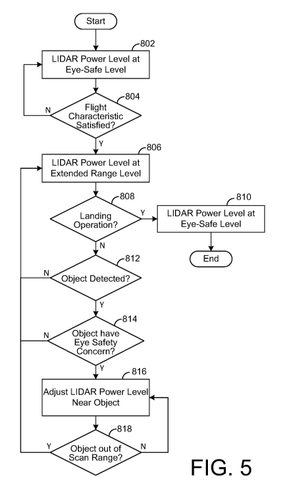
[0045] An exemplary use and operation of the system 5 in order to
modulate the
range and power level of a LIDAR sensor 30 of the aircraft 10 will be
described in more
detail below with reference to FIG. 5. For illustrative purposes, it will be
assumed that
the aircraft 10 is located on the ground and about to initiate a takeoff
operation.
[0046] At step 802, the LIDAR control logic 355 can operate the LIDAR
sensor
30 at the eye safe level since the aircraft 10 is either located on the ground
or initiating a
takeoff operation. A determination is then made as to whether the aircraft 10
has
satisfied a predefined flight characteristic (e.g., reached a predetermined
phase of flight)
associated with the aircraft 10 at step 804. The predefined flight
characteristic may
correspond to a measurement of altitude, a transition to a particular flight
configuration
(e.g., a configuration for hover flight or forward flight), or a location of
the aircraft.
Further, reaching a predetermined phase of flight can be one or more of the
aircraft 10
reaching a predefined altitude or entering a new altitude range, the aircraft
transitioning
to a new flight configuration (e.g., transitioning between a configuration for
hover flight
and forward flight), or the aircraft reaching a predefined location along a
flight plan (e.g.,
entering or arriving at a less populated area or an urban area). As an
example, once the
aircraft 10 reaches a certain altitude (e.g., cruise altitude), transitions to
a configuration
- 14 -
CA 03068280 2019-12-20
WO 2019/005141 PCT/US2017/040461
for forward flight, or leaves an urban area to a sparsely populated area, it
can be
assumed that the risk of eye injury has sufficiently diminished such that the
transmit
power of the LIDAR sensor may be increased, as will be described below.
[0047] Referring to step 804, if the aircraft 10 has not satisfied the
flight
characteristic, the process returns to step 802 and the LIDAR control logic
355 can
continue to operate the LIDAR sensor 30 at the eye safe level. However, if the
aircraft
has satisfied the flight characteristic, the LIDAR control logic 355 can
operate the
LIDAR sensor 30 at the extended range level in step 806. As shown in FIG. 6,
the
LIDAR sensor 30 can be operated at the eye safe level while the aircraft 10 is
ascending
to the cruise elevation. Once the aircraft 10 reaches the cruise elevation,
the LIDAR
control logic 355 can increase the power level of the LIDAR sensor 30 to the
extended
range level.
[0048] Next, at step 808, a determination is made as to whether the
aircraft 10 is
initiating a landing operation. If the aircraft 10 is initiating a landing
operation, the LIDAR
control logic 355 can operate the LIDAR sensor 30 at the eye safe level at
step 810
since there is an expectation that people or animals are within the scan range
of the
LIDAR sensor 30 and the process can end. If the aircraft 10 is not performing
a landing
operation at step 808, a determination can be made as to whether the aircraft
10 has
detected an object 15 within the scan range of the LIDAR sensor 30 at step
812. The
sense and avoid logic 350 can receive signals from sensors 20, 30 to make a
determination as to whether there is an object 15 within the scan range of the
LIDAR
sensor 30. If the sense and avoid logic 350 has not detected an object 15 in
the scan
range of the LIDAR sensor 30, the process returns to step 806 and the LIDAR
control
logic 355 can continue to operate the LIDAR sensor 30 at the extended range
level.
However, if the sense and avoid logic 350 has detected an object 15 in the
scan range
of the LIDAR sensor 30, the LIDAR control logic 355 can then determine if the
object 15
poses an eye safety concern at step 814. As discussed above, if the object 15
is
associated with a person or animal and is at a sufficiently close distance to
the LIDAR
sensor 30, then the object 15 has as eye safety concern.
[0049] If the LIDAR control logic 355 determines that the object 15 does
not
have an eye safety concern, the process returns to step 806 and the LIDAR
control logic
355 can continue to operate the LIDAR sensor 30 at the extended range level.
However, if the LIDAR control logic 355 determines that the object 15 does
have an eye
safety concern, the LIDAR control logic 355 can reduce the power level of the
LIDAR
- 15-
CA 03068280 2019-12-20
WO 2019/005141 PCT/US2017/040461
sensor 30 near the object 15 at step 816. As discussed above, the portion of
the scan
range of the LIDAR sensor 30 that is associated with the object 15 having eye
safety
concerns can be operated at a reduced power level that corresponds to either
the eye
safe level or an intermediate level that does not pose a risk of eye damage to
the person
or animal associated with the object 15 at the corresponding distance between
the
object 15 and LIDAR sensor 30.
[0050] After the LIDAR control logic 355 adjusts the power level of the
LIDAR
sensor 30 near the object 15, the LIDAR control logic 355 determines whether
the object
has exited the scan range for the LIDAR sensor 30 at step 818. The LIDAR
control logic
355 can determine if the object 15 has exited the scan range for the LIDAR
sensor 30 by
receiving updated information from the sense and avoid logic 350 that
indicates the
object 15 has exited the scan range. An object 15 can exit the scan range for
the LIDAR
sensor 30 by travelling in a direction or elevation away from the scan range
of the LIDAR
sensor or by having the aircraft 10 alter its flight path or elevation as part
of a collision
avoidance algorithm. If the object 15 has not exited the scan range for the
LIDAR
sensor 30, the process returns to step 816 and the LIDAR control logic 355 can
continue
to operate the LIDAR sensor 30 at the reduced power level for the
corresponding
portion of the scan range as discussed above. However, if the object 15 has
exited the
scan range for the LIDAR sensor 30, the process returns to step 806 and the
LIDAR
control logic 355 can operate the LIDAR sensor 30 at the extended range level.
[0051] In one exemplary embodiment as shown in FIG. 7, three objects 15
(a
mountain, a drone and a helicopter) can be detected within the scan range for
the LIDAR
sensor 30. As previously discussed, the LIDAR control logic 355 can evaluate
each of
the objects 15 and determine whether there are any eye safety concerns
associated with
each of the objects 15. Since the helicopter has an expectation of a person
being
located with it, the LIDAR control logic 355 identifies the helicopter as
having an eye
safety concern and identifies the drone and mountain as not having any eye
safety
concerns. In response to the determination by the LIDAR control logic 355
regarding the
helicopter, the LIDAR control logic 355 adjusts the power level for the LIDAR
sensor 30
in the area around the helicopter from the extended range level to a reduced
range level
as shown in FIG. 8. Depending on the distance between the LIDAR sensor 30 and
the
helicopter, the reduced range level may be either the eye safe level or an
intermediate
level. Further, the LIDAR control logic 355 can operate the LIDAR sensor 30 at
the
reduced range for a zone Z around the location of the helicopter as also shown
in FIG. 8.
- 16 -
CA 03068280 2019-12-20
WO 2019/005141 PCT/US2017/040461
The zone Z includes the angular offsets around the location of the helicopter
to ensure
that a beam or pulse from the LIDAR sensor 30 does not contact a person in the
helicopter. FIG. 9 shows the time period for which the LIDAR control logic 355
provides
the reduced range level for the LIDAR sensor 30 as a result of the detection
of the
helicopter until the helicopter leaves the scan range of the LIDAR sensor 30.
[0052] The foregoing is merely illustrative of the principles of this
disclosure and
various modifications may be made by those skilled in the art without
departing from the
scope of this disclosure. The above described embodiments are presented for
purposes
of illustration and not of limitation. The present disclosure also can take
many forms
other than those explicitly described herein. Accordingly, it is emphasized
that this
disclosure is not limited to the explicitly disclosed methods, systems, and
apparatuses,
but is intended to include variations to and modifications thereof, which are
within the
spirit of the following claims.
[0053] As a further example, variations of apparatus or process
parameters
(e.g., dimensions, configurations, components, process step order, etc.) may
be made to
further optimize the provided structures, devices and methods, as shown and
described
herein. In any event, the structures and devices, as well as the associated
methods,
described herein have many applications. Therefore, the disclosed subject
matter
should not be limited to any single embodiment described herein, but rather
should be
construed in breadth and scope in accordance with the appended claims.
- 17-