Note: Descriptions are shown in the official language in which they were submitted.
CA 03073034 2020-02-13
WO 2019/036361 PCT/US2018/046490
METHODS AND SYSTEMS FOR IMPROVING THE PRECISION OF
AUTONOMOUS LANDINGS BY DRONE AIRCRAFT ON LANDING TARGETS
CROSS REFERENCE TO RELATED APPLICATION
[0001] This application claims priority from U.S. Provisional Patent
Application No.
62/545,203 filed on August 14, 2017 entitled METHODS AND SYSTEMS FOR IMPROVING
THE
PRECISION OF AUTONOMOUS LANDINGS BY DRONE AIRCRAFT ON LANDING TARGETS,
which is hereby incorporated by reference.
BACKGROUND
[0002] The present application relates generally to autonomous drone
aircraft and,
more particularly, to methods and systems for precisely landing such aircraft
on landing
targets using active fiducial markers.
[0003] VTOL (vertical take-off and land) aircraft, such as multirotor
copters (e.g.,
quadcopters) and similar aircraft, can be configured as autonomous drones that
include
software enabling the drone to perform one or more functions on its own (e.g.,
flying a
particular route, taking off, and landing). These systems can be configured to
land on a
particular landing target, such as a docking station, base station, hanger,
runway, or the like.
Landing targets can be stationary or moving. They can be used, e.g., to
charge, transfer data,
swap components, and/or house the aircraft. These systems can employ GPS
navigational
mechanisms, vision sensors, inertial measurement sensors, distance sensors, or
the like.
[0004] However, traditional combinations of software and sensors, such as
GPS,
inherently include positional errors. As shown in FIG. 1, such errors can lead
to
misalignment of the drone 100 relative to a landing target 104 during landing.
Such
misalignment can prevent the drone from making a physical or electromagnetic
connection
with the landing target 104, thereby preventing data transfer, object
retrieval (e.g., for
package delivery), safe enclosure of system, and/or charging of the drone's
battery without
manual intervention.
1
CA 03073034 2020-02-13
WO 2019/036361 PCT/US2018/046490
BRIEF SUMMARY OF THE DISCLOSURE
[0005] In accordance with one or more embodiments, a computer-implemented
method is disclosed of guiding an autonomous drone aircraft during descent to
a landing
target. The method features the steps of: (a) acquiring an image using a
camera on the
drone aircraft of an active fiducial system at the landing target; (b)
verifying the active
fiducial system in the image by comparing the image to a stored model or
representation of
the active fiducial system; (c) determining a relative position and/or
orientation of the
drone aircraft to the landing target using data from the image; (d) using the
relative position
and/or orientation determined in step (c) to guide the drone aircraft toward
the landing
target; and (e) repeating steps (a) through (d) a plurality of times.
[0006] In accordance with one or more further embodiments, a system is
disclosed
comprising an active fiducial system at a landing target and an autonomous
drone aircraft
capable of landing at the landing target. The autonomous drone aircraft
includes a camera
for acquiring an image of the active fiducial system. The autonomous drone
aircraft also
includes a control system configured to: (a) verify the active fiducial system
in the image by
comparing the image to a stored model or representation of the active fiducial
system; (b)
determine a relative position and/or orientation of the drone aircraft to the
landing target
using data from the image; (c) use the relative position and/or orientation
determined in (c)
to guide the drone aircraft toward the landing target; and (e) repeat (a)
through (d) a
plurality of times for successive images acquired by the camera.
BRIEF DESCRIPTION OF THE DRAWINGS
[0007] FIG. 1 is a simplified diagram illustrating misalignment of a
drone aircraft to a
docking station.
[0008] FIG. 2 is a simplified block diagram illustrating a representative
autonomous
drone aircraft in accordance with one or more embodiments.
[0009] FIG. 3 is a simplified diagram illustrating drone offset along the
z-axis relative
to a docking station.
2
CA 03073034 2020-02-13
WO 2019/036361 PCT/US2018/046490
[0010] FIG. 4 is a simplified diagram showing a landing target outside of
the drone
camera field of view (FOV) when the drone is at a low altitude.
[0011] FIG. 5 illustrates a representative square-shaped fiducial marker
constellation
pattern in accordance with one or more embodiments.
[0012] FIG. 6 illustrates a representative circular-shaped fiducial
marker
constellation pattern in accordance with one or more embodiments.
[0013] FIG. 7 illustrates a representative line-shaped fiducial marker
constellation
pattern in accordance with one or more embodiments.
[0014] FIG. 8 illustrates a representative fiducial marker constellation
pattern with a
center fiducial in accordance with one or more embodiments.
[0015] FIG. 9 shows a flow chart illustrating an exemplary process for
utilizing a set
of active fiducial markers to precisely land a drone aircraft in accordance
with one or more
embodiments.
[0016] Like or identical reference numbers are used to identify common or
similar
elements in the drawings.
DETAILED DESCRIPTION
[0017] Various embodiments disclosed herein relate to methods and systems
for
improving the precision of autonomous landings by drone aircraft using active
fiducial
markers at landing targets.
[0018] FIG. 2 is a simplified block diagram of select components of a
representative
drone aircraft 100 in accordance with one or more embodiments. The drone
aircraft 100
includes a control system 106 for controlling operation of the aircraft, a
battery 108 for
powering the aircraft, a set of rotors 110 driven by motors 112, a camera 114,
and sensors
116. The sensors 116 can include, e.g., a GPS device, an inertial measurement
sensor, a
distance sensor, and a barometer.
3
CA 03073034 2020-02-13
WO 2019/036361 PCT/US2018/046490
[0019] The control system includes a flight controller system for
maneuvering the
drone by controlling operation of the rotors 110. The control system also
includes a vision
system that uses computer vision techniques for detecting a set of active
fiducial markers at
a landing target for improving the precision of landings as will be discussed
in further detail
below.
[0020] The control system can include one or more microcontrollers,
microprocessors, digital signal processors, application-specific integrated
circuits (ASIC),
field programmable gate arrays (FPGA), or any general-purpose or special-
purpose circuitry
that can be programmed or configured to perform the various functions
described herein.
[0021] Computer vision techniques are used in accordance with one or more
embodiments to improve the precision of the autonomous drone landing, and thus
the
reliability of a successful docking event with a docking station. In
accordance with one or
more embodiments, one or more fiducial markers, such as light-emitting
beacons, of known
position and arrangement are configured at the landing target. The fiducials
along with the
camera 114 mounted on the drone aircraft in a known position and orientation,
enable
high-speed state estimation of the aircraft relative to the landing target.
This state estimate,
i.e., relative position and/or orientation, is used to control the aircraft
precisely during the
descent until successful landing has been achieved.
[0022] Using light-emitting fiducials are beacons has several benefits.
One significant
benefit is the ability to match the wavelength of the light emitted by the
beacon with a
band-pass filter on the camera that only allows that wavelength of light to be
imaged. By
choosing these values, it allows an image analysis algorithm used in the
vision system to
extract the fiducial features much more easily than standard computer vision
techniques.
[0023] Such fiducials improve multiple things: the likelihood of detecting
and
segmenting an information-producing feature from the unrelated background
features, the
computational speed at which this detection can happen, and the accuracy and
precision of
the position and/or orientation measurements that can be derived. Each
improvement
increases the likelihood of precise control during landing.
4
CA 03073034 2020-02-13
WO 2019/036361 PCT/US2018/046490
[0024] In one or more embodiments, the fiducial-camera system can be
optimized
to further block-out unwanted background noise by tuning the camera to a
narrow band of
light known to be emitted by the fiducial. In addition to visible spectrum
light, such light can
be infrared or other non-visible spectra.
[0025] Important to a smooth, reliable, and precise autonomous landing
are
accurate, high-speed estimates of relative (i.e., above target level) position
(i.e., x, y, and z),
and relative orientation (i.e., roll, pitch, and yaw). These are the six
degrees of freedom of a
rigid body in three-dimensional space. A single fiducial point, however, will
only generate
information in two of these degrees of freedom, e.g., x and y. Though useful,
it is often
insufficient to only rely on these two dimensions for precise, reliable
control.
[0026] For example, as illustrated in FIG. 3, current altitude sensors,
or sensors that
measure an aircraft's relative position along the z-axis, are often not
sufficient to guarantee
a reliable and accurate precision landing. For example, current GPS units and
barometers
often provide measurements with errors on the order of multiple meters. In
addition, sonar
and laser range finders can be unreliable over terrain with varying heights,
such as the
difference between the top surface of a docking station and the ground.
[0027] To overcome this, multiple fiducial markers of known positions,
e.g., in a
fiducial constellation, can be used to extract relative pose in multiple
degrees of freedom.
For example, a fiducial constellation consisting of two points with known
spacing can be
used to extract distance information. The number of pixels between the points
in the image,
combined with the known spacing in the real world, allows the distance between
the
camera and the fiducial to be calculated. In the case where the camera is
pointed down, this
distance is equivalent to the altitude.
[0028] The landing procedure for an aircraft in this scenario naturally
involves
starting at farther distances and approaching towards the target until the
aircraft has
landed. To properly utilize a fiducial constellation system such as the one
described above,
limitations of camera resolution and camera FOV at these various distances
should be
addressed.
CA 03073034 2020-02-13
WO 2019/036361 PCT/US2018/046490
[0029] At higher altitudes, the restrictions on pixel resolution may
cause the camera
to be unable to distinguish smaller-dimensioned fiducial arrangements from
each other and
from the background. For example, if one used a constellation of four light-
emitting beacons
arranged in a square pattern to extract relative x, y, and z position, at
higher altitudes these
points may appear too close together or too dim to extract any useful
information. At these
higher altitudes, the fiducial constellation is small in the camera image. In
this case, a single
pixel of error is a larger percentage of the overall constellation size in the
image as
compared to lower altitudes where the constellation is larger in the image.
[0030] At lower altitudes, the restrictions of a static FOV will cause
the camera to
view smaller and smaller physical areas. As shown in FIG. 4, as the aircraft
approaches the
landing target 104, a constellation that had appropriate dimensions for a
higher altitude
(i.e., spaced far apart) may exist outside the FOV 130 of the camera at this
lower altitude
with its previous offset along the x and y axes, rendering it unusable.
[0031] In accordance with one or more embodiments, to overcome this
technical
hurdle, a set of progressively smaller constellations are used that are
appropriate for each
stage of the descent, guiding the aircraft into its final, precise location.
By way of example,
as shown in FIG. 6, such constellations can comprise a series of nested
circles 144 (each
circle comprising multiple fiducials 140 arranged in a circular pattern) with
decreasing
diameters. FIG. 5 shows constellations comprising a series of squares 142
(each square
comprising multiple fiducials 140 arranged in a square pattern) with
decreasing dimensions.
FIG. 7 shows a series of lines 146 (each line comprising multiple fiducials
140 arranged in a
line). Suitable fiducials systems could include any combination or permutation
of fiducial
constellations that get progressively smaller (i.e. closer to the center point
of the camera
FOV) as the aircraft approaches the landing target.
[0032] Alternatively, instead of using multiple beacons, a "single"
fiducial having a
two-dimensional form (such as a solid square or circle) may be used to elicit
the same
information. In other embodiments, multiple beacons can be arranged, e.g.,
next to one
another (e.g., in an LED strip) to form such a continuous shape.
6
CA 03073034 2020-02-13
WO 2019/036361 PCT/US2018/046490
[0033] Alternatively, the camera may have an adjustable field of view
(FOV) that
allows the camera to gradually widen the field of view and zoom out as the
vehicle
approaches the landing target. This would produce a similar effect.
[0034] In one or more optional exemplary embodiments, to utilize such a
constellation of beacons for precision landing, the constellation must appear
within the FOV
of the drone-mounted camera. To improve this likelihood of this scenario, the
constellation
is preferably constructed in a pattern equidistant from the center point of
the landing
target, or symmetrical about the x and y axes, so that position errors do not
produce a
biased negative effect in any particular direction. Possible exemplary
embodiments of this
are a set of multiple beacons arranged in a square pattern, a set of multiple
beacons
arranged in a circular pattern, or the like. Also, instead of multiple
beacons, a "single"
fiducial having a two-dimensional form (such as a solid square or circle) may
be used to elicit
the same information. Multiple beacons can be arranged next to one another
(e.g., in an
LED strip) to form a continuous shape.
[0035] In an alternate embodiment, one or more of the series of
constellations may
be offset by known distances from the center point of the landing target.
[0036] However, perfect radial symmetry is not preferred because it
introduces
ambiguity in the orientation of the constellation. For example, a perfect
square constellation
looks identical when viewed from any of four directions (rotated by 90
degrees). This type of
constellation would require additional information to resolve the ambiguous
solutions to
the correct orientation. One solution to this is to use the other sensors,
e.g. magnetometer,
to resolve the ambiguity. Another solution is to add one or several
asymmetrically located
beacons in the constellation. For example, add a fifth beacon to the square
constellation
that is not symmetric. This allows the algorithm to independently eliminate
ambiguity in a
self-contained manner, without additional sensors.
[0037] In one or more exemplary embodiments, a center fiducial is
provided. The
center fiducial is aligned with the drone-mounted camera to maximize the
locations from
which the fiducial will be within the FOV of the camera. The center fiducial
will be lined up
7
CA 03073034 2020-02-13
WO 2019/036361 PCT/US2018/046490
with the center of the image during an ideal descent, and can be viewed the
entire landing
process until the drone is on the landing target.
[0038] This allows the vision estimate to guide the control for the entire
landing
procedure, if at the very least with a single fiducial. If this is not done,
the last portion of the
descent may not have information from the camera system, and will therefore be
relying
solely on the imprecise sensors mentioned previously (e.g., GPS) and could
drift away from
the landing target in the final moments.
[0039] As shown in FIG. 8, the presence of a center fiducial 152 also
increases the
number of fiducials for each and every constellation 154 by one (i.e. a 5-
point star vs. a 4-
point square), with the position of this center fiducial increasing the
likelihood that at least
two points will be viewed at all times for each constellation, thus increasing
the robustness
of the estimate. Center fiducial constellation connectors are indicated at
150.
[0040] The center fiducial 152 can also be used with fiducials having a
two-
dimensional form such as the solid square or circle discussed above.
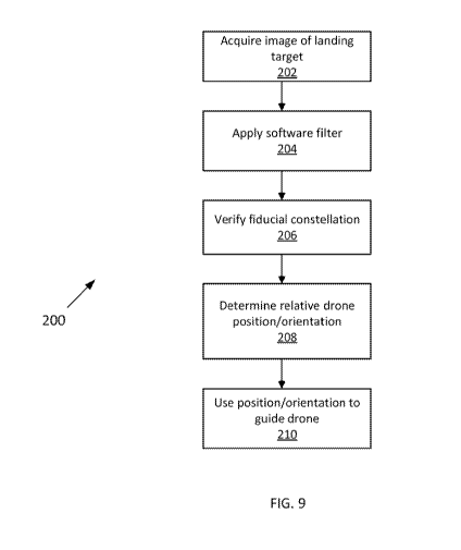
[0041] FIG. 9 shows a flow chart 200 illustrating an exemplary process for
utilizing a
set of active fiducial markers at the landing site to precisely land a drone
in accordance with
one or more embodiments.
[0042] At step 202, an image of the landing site with the active fiducial
markers is
acquired by the camera 114 on the drone. In accordance with one or more
embodiments,
the camera is equipped with a band pass filter matching the frequency of light
known to be
emitted by the fiducial markers. The camera thus captures a darkened image
with
substantially only white features representing the fiducial markers.
[0043] At step 204, the vision system processes the acquired image by
applying a
software filter to the image to filter out unrelated background features like
reflections from
the sun and other objects.
[0044] At step 206, the vision system verifies the presence of the
fiducial markers in
the image. The vision system knows the general estimated position/orientation
of the drone
relative landing target based on location information received from sensors on
the drone
8
CA 03073034 2020-02-13
WO 2019/036361 PCT/US2018/046490
(e.g., a GPS device and barometer) or from a previous position/orientation
estimate from
the vision system if available. The vision system also stores in memory a
representation or
model of the fiducial marker system in memory. The representation or model
defines the
arrangement of fiducial markers in the fiducial system. The representation or
model can be,
e.g., an image of the fiducial marker system or data specifying the (x, y, z)
coordinates of the
fiducial markers.. The vision system compares the captured image to the stored
representation or model, accounting for distortions in the captured image
based on the
relative position/orientation of the drone to the landing site. The vision
system thereby
verifies the fiducial constellation in the image and also uniquely identifies
each of the
fiducial markers in the constellation.
[0045] At step 208, the vision system uses the captured image to
determine its
relative position/orientation to the landing site.
[0046] At step 210, the vision system provides the position/orientation
information
to the flight controller, which guides the drone to the landing site.
[0047] These steps are continuously repeated until the drone has
successfully
landed at the landing site. The camera 114 continuously captures images, e.g.,
at 50 frames
per second. The image analysis described above is repeated for each frame.
[0048] The processes of the control system described above may be
implemented in
software, hardware, firmware, or any combination thereof. The processes are
preferably
implemented in one or more computer programs executing on one or more
processors in
the control system. Each computer program can be a set of instructions
(program code) in a
code module resident in a random access memory of the control system. Until
required by
the controller, the set of instructions may be stored in another computer
memory.
[0049] Having thus described several illustrative embodiments, it is to
be
appreciated that various alterations, modifications, and improvements will
readily occur to
those skilled in the art. Such alterations, modifications, and improvements
are intended to
form a part of this disclosure, and are intended to be within the spirit and
scope of this
disclosure. While some examples presented herein involve specific combinations
of
functions or structural elements, it should be understood that those functions
and elements
9
CA 03073034 2020-02-13
WO 2019/036361 PCT/US2018/046490
may be combined in other ways according to the present disclosure to
accomplish the same
or different objectives. In particular, acts, elements, and features discussed
in connection
with one embodiment are not intended to be excluded from similar or other
roles in other
embodiments.
[0050] Additionally, elements and components described herein may be
further
divided into additional components or joined together to form fewer components
for
performing the same functions.
[0051] Accordingly, the foregoing description and attached drawings are
by way of
example only, and are not intended to be limiting.