Note: Descriptions are shown in the official language in which they were submitted.
INDICATOR INTERPOLATION TO
PREDICT A WEATHER STATE
CROSS REFERENCE TO RELATED APPLICATIONS
[0001] This application claims the benefit of priority to U.S.
Provisional Application
No. 62/558,643, filed September 14, 2017.
TECHNICAL FIELD
[0002] This description relates to estimation of weather information
using field-driven
data obtained from multiple remote weather stations.
BACKGROUND
[0003] Farmers, producers, and agronomists use farm management systems to
support
their agronomic management and agricultural planning process. Farm management
and
agricultural management systems, commonly require a variety of data inputs to
perform
necessary calculations for the agricultural management cycle. Many of these
inputs are
categorical variables and properties that support agricultural management life
cycles,
including and not limited to, soil properties, elevation, seed type, crop
variety, nutrient
applications, weather, and so on.
100041 Meanwhile, when each categorical variable is examined, there are
many additional
properties that comprise the categorical variable. With particular interest in
the attributes that
comprise weather properties, which may include, temperature, humidity,
precipitation, wind
speed or direction, to provide a few examples. Whenever available, the weather
information
collected directly from the agriculture field will drive more accuracy in the
decision-making
process.
1
Date Recue/Date Received 2021-08-11
CA 03073290 2020-02-18
WO 2019/051590
PCT/CA2018/051127
[0005] One approach to collect weather data directly from the field is to
install weather
stations at all desired locations. However, by installing hardware at every
desired location,
this may impose a substantial cost. Therefore, a method to retrieve and
leverage data from
already existing weather stations would be beneficial. Furthcr, a method that
can
approximate weather data for locations that do not include a weather station
would be
beneficial.
SUMMARY
[0006] Described is a method for predicting a weather state by
interpolating weather
information from weather measurement systems located in or near a query
location such as an
agricultural field. The method is more efficient, less computationally
expensive, easier to
interpret and more accurate than more traditional weather interpolation
methods.
[0007] In particular, a weather prediction model accesses a number of
indicator weather
states from known and nearby weather measurement systems. Each weather
measurement
system is at a measurement location and configured to determine a weather
state at the
measurement location. The weather prediction model predicts a weather state
for a query
location using the weather states deteiniined by the weather measurement
systems.
Predicting the weather state at the query location may consider the number of
weather
measurement systems near the query location, their geometrical configuration,
and the values
that are measured by each such weather measurements system. The values
measured by the
weather measurement systems are used to predict a weather state at the query
location. Using
the wearer prediction model reduces the need to have a weather measurement
system
installed on every desired location in an area.
[0008] Predicted weather states at the query location may impact decisions
that
agronomists, producers, farmers, or faun managers make throughout the year.
For example,
this the weather prediction model may be applied to historical data that has
already been
collected, determine a weather forecast, and a farmer may choose a farming
process based on
the forecast.
BRIEF DESCRIPTION OF THE DRAWINGS
[0009] FIG. 1 is an illustration of a system environment for predicting a
weather state at
2
CA 03073290 2020-02-18
WO 2019/051590
PCT/CA2018/051127
a location using a weather prediction model, according to one example
embodiment.
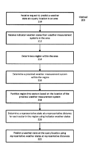
[0010] FIG. 2 is a flow diagram illustrating an example method for
predicting a weather
state at a query location, according to one example embodiment.
[0011] FIG. 3 is an illustration of an area including a query location and
a number of
weather measurement systems, according to one example embodiment.
[0012] FIG. 4 is an illustration of weather measurement systems in a region
within a
proximity distance from the query location, according to one example
embodiment.
[0013] FIG. 5 is an illustration of a proximal weather measurement system
within the
prediction area, according to one example embodiment.
[0014] FIG. 6 is an illustration of the region partitioned into four
sectors, according to
one example embodiment.
[0015] FIG. 7 is an illustration of representative locations at
representative distances for
each sector of a region used to predict a weather state at the query location,
according to one
example embodiment.
[0016] The figures depict various embodiment for purposes of illustration
only. One
skilled in the art will readily recognize from the following discussion that
alternative
embodiments of the structures and methods illustrated herein may be employed
without
departing from the principles described herein.
DETAILED DESCRIPTION
I. Introduction
[0017] This method seeks to predict a weather state at a query location, or
locations, in an
area by interpolating results obtained from one or more weather measurements
systems in the
area. An area is some amount of geographic area that may include weather
measurement
systems and agricultural fields. Herein, a weather state is a quantification
or measurement of
some aspect of the weather such as, for example, precipitation, humidity,
temperature,
pressure, wind speed, etc. Thus, a predicted weather state is a predicted
value of a weather
state at a particular location in the area. Location and area centric weather
information (e.g.,
weather states) is obtained from weather measurement systems or other sources
of data to
drive better and more efficient interpolated results for any missing locations
within the area.
System Environment
3
CA 03073290 2020-02-18
WO 2019/051590
PCT/CA2018/051127
[0018] FIG. 1 illustrates a system environment 100 for predicting a weather
state at a
query location within an area. Within the system environment 100, a client
system 110
predicts a weather state at a query location using a weather prediction model
112. A network
system 120 accesses current and historical weather states ("indicator weather
states" in
aggregate) from a weather measurement system 130 via a network 140. When
predicting a
weather state, a client system 110 may request indicator weather states via
the network 140
and the network system 120 may provide the indicator weather states in
response.
[0019] A client system 110 is any system capable of executing a weather
prediction
model 112 to predict a weather state at a query location 47. The client system
110 may be a
computing device, such as, for example, a personal computer. Network system
120 may also
be a computing device, such as, for example, a set of servers that can operate
with or as part
of another system that implements network services for facilitating
determining predicted
weather states. Network system 120 and client system 110 comprise any number
of hardware
components and/or computational logic for providing the specified
functionality. That is, the
systems herein can be implemented in hardware, firmware, and/or software
(e.g., a hardware
server comprising computational logic), other embodiments can include
additional
functionality, can distribute functionality between systems, can attribute
functionality to more
or fewer systems, can he implemented as a standalone program or as part of a
network of
programs, and can be loaded into memory executable by processors.
[0020] In one example, a client system 110 is operated by a user
responsible for
managing crop production in an agricultural field within the area, but could
be operated by
any other user. The user of the client system 110 inputs a query location lq
into the weather
prediction model 112 and the weather prediction model 112 predicts a weather
state for that
query location 47 in response. Generally, the query location 47 is the
location of the
agricultural field, or a portion of the agricultural field, managed by the
user, but could be any
other query location 47. In some instances, the query location 47 may be the
location of the
client system 110.
[0021] A client system 110 is connected to a network system 120 via a
network 140. The
network system 120 facilitates the weather prediction model 112 accurately
predicting a
weather state at the query location lg. In various examples, the network
system 120 may
access indicator weather states from weather measurement systems 130 in the
area. The
network system 120 can provide the indicator weather states to the client
system 110 such
that the weather prediction model 112 can predict a weather state at the query
location lg. In
4
CA 03073290 2020-02-18
WO 2019/051590
PCT/CA2018/051127
some examples, the network system 120 (or the client system 110) may store any
of the
indicator weather states in a datastore. Stored indicator weather states may
be accessed by
weather prediction model 112 to predict a weather state at a query location
lg. In some
examples, the weather prediction model 112 is executed on a network system 120
and a client
system 110 accesses the weather prediction model via the network 140.
[0022] A weather measurement system 130 is any system or device that can
provide
indicator weather states to the network system 120 and client system 110. In
some instances,
a weather measurement system 130 is a system or device capable of measuring
and/or
quantifying an aspect of the current weather (i.e., current weather states).
For example, a
weather measurement system 130 may be a weather station operated the National
Weather
Service, but could be any other weather measurement system 130. In other
instances, a
weather measurement system 130 may be an external system that stores
previously measured
weather states (i.e., historical weather states). For example, the weather
measurement system
130 may be a database that stores historical records of weather in the area as
indicator
weather states. In either example, a weather measurement system may provide
indicator
weather states to network system 120 or client system 110. Notably, while
system
environment 100 illustrates two weather measurement systems 130, the system
environment
100 can include any number of weather measurement systems 130.
[0023] The network 140 represents the communication pathways between
systems in the
environment 100. In one embodiment, the network is the Internet, but can also
be any
network, including but not limited to a LAN, a MAN, a WAN, a mobile, wired or
wireless
network, a cloud computing network, a private network, or a virtual private
network, and any
combination thereof In addition, all or some of links can be encrypted using
conventional
encryption technologies such as the secure sockets layer (SSL), Secure HTTP
and/or virtual
private networks (VPNs). In another embodiment, the entities can use custom
and/or
dedicated data communications technologies instead of, or in addition to, the
ones described
above.
[0024] Within the system environment 100, each indicator weather state is
associated
with a measurement location 1,õ. Each measurement location 1õ, is a distance
d,õ away from
the query location 4. Generally, the measurement location /õ, of an indicator
weather state is
the location at which a weather measurement system 130 determined the
indicator weather
state. The distance dõ, between the query location /,/ and the measurement
location /,,, can be
determined by the weather prediction model 112 when predicting a weather
state.
CA 03073290 2020-02-18
WO 2019/051590
PCT/CA2018/051127
Predicting a Weather State
[0025] The client system 110 uses a weather prediction model 112 to predict
a weather
state for a query location hi. The weather prediction model 112 receives a
query location 1,i as
input and provides a predicted weather state at the query location 1,1 as
output. When
predicting a weather state, the weather prediction model 112 may request and
receive
indicator weather states from network system 120 to facilitate predicting the
weather state.
Network system 120 may access the indicator weather states from a storage
database of the
network system 120 or from weather measurement systems 130 as previously
described.
[0026] FIG. 2 illustrates a method 200 to predict a weather state. The
method 200 may
be executed by a weather prediction model 112 executing on client system 110.
The method
200 will be described in reference to FIGs. 3-7. In various embodiments, the
method 200 can
include additional or fewer steps and the steps may occur in any order.
[0027] To begin, a weather prediction model 112 receives 210 a request to
predict a
weather state at a query location 1õ in an area. In this example, an operator
of the client
system 110 inputs the query into the weather prediction model 112 and
initializes the request.
Here, the query location hi is an agricultural field in an area and the
operator is a person
responsible for managing crop production of the agricultural field. The area
also includes a
number of weather measurement systems 130 that can provide indicator weather
states for the
weather prediction model 112. To demonstrate, FIG. 3 is an illustration of an
area 310. The
area 310 is shown as a rectangle with a black boundary. Within the area 310 is
a query
location hi 320 and weather measurement systems 130. The query location hi 320
is
illustrated as a triangle and the weather measurement systems 130 are
illustrated as dots.
[0028] Returning to FIG. 2, the weather prediction model 112 receives 212 a
set of
indicator weather states from weather measurement systems 130 in the area 310.
In some
examples, the weather prediction model 112 receives the indicator weather
states in response
to the client system 110 requesting the indicator weather states from network
system 120. In
other examples, the indicator weather states are stored on a database of
client system 110 and
the weather prediction model 112 receives (or accesses) the predictive states
from the
database. The measurement location 1õ, for each indicator weather state is the
location of the
weather measurement system 130 in the area 310 that measured the indicator
weather state.
Thus, referring to FIG. 3, each of the weather measurement systems 130 is a
measurement
location lõ, for an indicator weather state used by the weather prediction
model 112. The
weather prediction model 112 may determine a measurement distance dõ,
indicating the
6
CA 03073290 2020-02-18
WO 2019/051590
PCT/CA2018/051127
distance between the query location /q and the measurement location in. That
is dõ, =
[0029] Returning to FIG. 2, the weather prediction model 112 determines 214
a region
within the area. The region is a geographical extent within the area 310 that
is within a
proximity distance dp from the query location lq. For context, a proximity
distance dp for a
region may be approximately 100 km. As such, a region may be approximately
thirty
thousand square kilometers while an area is over a hundred thousand square
kilometers, but
an area and a region may be any other size. The weather prediction model 112
only uses
indicator weather states from measurement locations /,õ within the region to
predict a weather
state. The proximity distance dp may be predetermined (e.g., 75 km), selected
by an operator
of a client system 110 (e.g., as a user input), or dynamically determined
based on a variety of
criteria. Some of the criteria for determining a proximity distance dp may
include the density
of weather measurement systems 130 surrounding the query location lq 320, a
threshold
number of weather measurement systems 130 to include in a region, the
reliability of weather
measurement systems 130, etc. Take, for example, a query location 4320
surrounded by
weather measurement systems 130 at a density of 3 weather measurement systems
130 per 50
square km. In this case, weather prediction model 112 determines a proximity
distance di, of
100 km. In another example, a query location /4 320 is surrounded by weather
measurements
systems 130 with a density of 10 weather measurement systems 130 per 50 square
km. In
this case, the weather prediction model 112 selects a proximity distance dp of
60 km because
of the increased density of weather measurement systems 130.
[0030] To demonstrate, FIG. 4 illustrates a region 410 determined by a
weather
prediction model 112 within an area 310. Here, the region 410 is illustrated
as a grey circle
bounded by a black ring and includes all the area within a proximity distance
dp 412 from the
query location 1q 320. The proximity distance dp 412 is indicated as a line.
The region 410 is
approximately circular with the query location /q 320 at the center of the
circle. In this
example, the proximity distance dp 412 is predetermined. Also within the
region 410 are
weather measurement systems 130 that are nearer the query location /q 320 than
the
proximity distance dp 412. That is, dm < dp for all of the weather measurement
systems 130
within the region 410. The weather prediction model 112 only uses indicator
weather states
from weather measurement systems 140 within the region 410 to predict a
weather state.
[0031] In some examples, the method 200 may determine a region 410 before
receiving
weather indicator states. In this case, only indicator weather states from
weather
measurement systems 130 within the region 410 are provided to the weather
prediction model
7
CA 03073290 2020-02-18
WO 2019/051590
PCT/CA2018/051127
112.
100321 Returning to FIG.2, the weather prediction model 112 determines 216
a proximal
weather measurement system 130 within a region 410 and, thereby, determines a
proximal
indicator weather state. A proximal indicator weather state is the most
important indicator
weather state for accurately predicting a weather state. A proximal weather
measurement
system is the weather measurement system 130 whose measurement location /õ, is
nearest the
query location 1q 320. That is, the proximal weather measurement system is the
weather
measurement system 130 in the region 410 with the smallest measurement
distance 4. To
demonstrate, FIG. 5 illustrates a proximal weather measurement system 510
determined by
the weather prediction model 112. The proximal weather measurement system 130
is the
weather measurement system 130 nearest the query location 320 in the region
410. The
proximal weather measurement system 510 is illustrated as a star, however, the
proximal
weather measurement system was previously illustrated as a dot in FIG. 3 and
FIG. 4.
[0033] Returning to FIG. 2, the weather prediction model 112 partitions 218
a region 410
into a number of sectors. Generally, each sector has approximately the same
amount of area,
but could have different areas. In one example, each sectors are sectors of a
circle, but could
form any other shape (e.g., boxes forming a rectangle, triangles forming a
triangle, etc.). In
some configurations, such as, for example, when the sectors are sectors of a
circle, the border
between each pair of sectors is a line passing from the query location 1q, 320
to a point the
proximity distance dp 412 away.
[0034] Weather prediction model 112 may determine the position of sectors
within a
region 410 based on the location of the proximal weather measurement system
510. In one
example, a first sector of the determined sectors is positioned within the
region such that a
line from the proximal weather measurement system 510 to the query location /q
320
approximately bisects the first sector. The remaining sectors are equally
spaced about the
region 410 based on the location of the first sector. For example, if the
region 410 is a circle,
the weather prediction model 112 may partition the region 410 into six equally
sized sectors.
Each of the six sectors have an arc of approximately 60 degrees. In this
example, the first
sector is placed within the region 410 such that a line between the proximal
weather
measurement system 510 and the query location /q approximately bisects a
sector such that 30
degrees of the sectors arc is on each side of the line. The remaining sectors
are placed around
the first sector to complete the circle.
[0035] To demonstrate, FIG. 6 illustrates a region 410 that has been
partitioned into four
8
CA 03073290 2020-02-18
WO 2019/051590
PCT/CA2018/051127
sectors 610A-610D by the weather prediction model 112. In this example, the
region 410 is
approximately circular and surrounds the query location /q 320 such that the
radius of the
region 410 is approximately the proximity distance dp 412. A line 612 that
connects the
proximal weather measurement system 510 to the query 320 location is
illustrated. Because
the region 410 is partitioned into four sectors 610, each sector 610 spans a
90 arc of the
circular region 410. A first sector 610A of the sectors 610 is positioned
within the region 410
such that the illustrated line 612 approximately bisects the sector 610A. That
is, the first
sector 610A is positioned such that 450 of the 900 arc of the first sector
610A is on each side
of the illustrated line 612. The remaining sectors 610B-D are positioned such
that they
complete the circular region 410 with the query location /q 320 at the center.
[0036] Returning to FIG. 2, the weather prediction model determines 220 a
representative
weather state at a representative location ir for each of the sectors 610. The
representative
weather state is a weather state that represents the weather in the sector
610. In one example,
the representative weather state for a sector 610 is an average of the
indicator weather states
for each weather measurement system 130 located in the sector 610. In another
example, the
representative weather state for a sector 610 uses an inverse distance
weighting method. That
is, indicator weather states that have measurement locations Iõ, closer to the
query location 1,1
are assigned larger weights compared to indicator weather states whose
measurement
locations /õ, are farther away. In other examples, some other function may be
used to
determine a representative weather state for a sector 610. In some examples,
weather
prediction model 112 may only use a pre-determined number of indicator weather
states from
weather measurement systems 510 located within a sector 610. For example, if a
sector 610
includes indicator weather states from 20 weather measurement systems 130,
weather
prediction model 112 may only use 10 of the indicator weather states. Further,
in some
examples, weather prediction model 112 may only use the indicator states from
the weather
measurement systems 130 in the sector 610 that are closest to the query
location /q 320.
[0037] The representative location lr for a sector is separated from the
query location /q
by a representative distance dr. That is, dr = In one example, the
representative
location ir for each sectors 610 is located within the sector 610 such that a
line connecting the
representative location Ir and the query location 1,1 approximately bisects
the sector 610. In
other examples, the line may not bisect the sector.
100381 In some cases, the weather determination model 112 can determine the
representative distance dr based on the sector 610. In one example, in the
sector 610
9
CA 03073290 2020-02-18
WO 2019/051590
PCT/CA2018/051127
including a proximal weather measurement system 510, the weather prediction
model 112
determines the representative distance dr for that sector 610 is the distance
between the
measurement location /,,, of the proximal weather measurement system 510 and
the query
location /q 320. Thus, the representative location Zr is the measurement
location l, of the
proximal weather measurement system 510. In the other sectors, the weather
prediction
model 112 determines a representative distance (Jr that is a harmonic average
of the distances
between the query location and the measurement locations 1,/ of the weather
measurement
systems 130 in that sector. Thus, in this case, the representative distance
(Jr may not coincide
with a measurement location 1õ, of a weather measurement system 130. In other
examples,
the weather prediction model 112 can deteiiiiine a representative distance dr
using any other
technique to average distances.
[0039] To demonstrate, FIG. 7 illustrates a region 410 with deteini;ned
representative
locations 710 at representative distances 712. Each representative location
710 is illustrated
as a dashed circle and each representative distance 712 is illustrated as a
dashed line. In the
sector 610A including the proximal weather measurement system 510, the
representative
location 710A is at the measurement location 1õ, of the proximal weather
measurement system
510. In the other sectors 610B-D, the representative locations 710B-D are at a
representative
distance 712B-D on a line bisecting its respective sector 610B-D. The
representative_
distances (Jr 712B-D for a sector 610B-D is the harmonic mean of the distances
between the
query location 1õ and the measurement locations 1õ, of the weather measurement
systems 130
in that sector 610B-D.
[00401 Returning to FIG. 2, the weather prediction model predicts 222 a
weather state for
the query location 1q using the representative weather state, representative
locations Zr 710,
and representative distances dr 712 for each sector 610. In one example, the
weather
prediction model 112 perfoinis a linear interpolation of representative
weather states between
representative locations /,- 710 at representative distances (Jr 712 within
sectors 610 on
opposite sides of the query location /q 520 to determine the predicted weather
state. The
predicted weather state at the query location ly is some function of the
interpolated pairs such
as, for example, mean, median, etc. In other examples, another function may be
used to
predict a weather state.
[0041] The predicted weather state is any weather state that can be
predicted by indicator
weather states. For example, if all of the weather measurement systems 130
have an indicator
weather state indicating a current amount of rain fall, the weather prediction
model generates
CA 03073290 2020-02-18
WO 2019/051590
PCT/CA2018/051127
a representative weather state at a representative location 1, 710 indicating
rain fall for each
sector 610. The weather prediction model 112 interpolates the representative
weather states
at the representative distances dr 712 of the representative locations l 710
to predict an
amount of rainfall at the query location ki 520. Of course, this is just an
example of
predicting a weather state. Weather prediction model 112 can use any indicator
weather
states described herein to predict a state.
100421 Weather prediction model 112 outputs the predicted weather state to
the operator
of the client system 110. The operator of the client system 110 may use the
predicted
weather state to apply real-time decision making for the current agricultural
life cycle in the
agricultural field. The predicted weather state may be stored on a database of
client system
110 or network system 120.
IV. Additional Model Outputs
[0043] In some examples, predicted weather states can be combined with
other predicted
weather states to generate a predicted weather map of the area. The predicted
weather map
can include any number of zones such that the predicted weather map represents
a zone-by-
zone map (or table) displaying current, historical, and/or predicted weather
states in the area.
The weather map includes no empty zones because of the predicted weather
states.
100441 Additionally, in some examples, current, historical, and/or
predicted weather
states may be combined about a sector 610 or zone in an area 310 to provide a
holistic view
of the sector 610 or zone. For example, if the weather states in the sector
indicate current rain
fall, high humidity, and a large amount of historical rain fall, the holistic
view may include
"flood risk." In another example, if the weather states in a zone indicate no
rain fall, high
temperatures, a low amount of historical rain fall, the holistic view may
include "drought."
[0045] The predicted weather states may be analyzed to predict a future
trend. For
example, weather prediction model 112 can use predicted weather states from a
previous
growing season, or seasons, to predict a weather state for the current season.
100461 In another example, a predicted weather state may be used by a
machine in a field
to take an action. For example, a predicted weather state indicating drought
may be sent to a
boom sprayer in a field and the boom sprayer may increase the amount of water
provided to
plants in response. Other examples of a farming machine utilizing a predicted
weather state
are also possible.
V. Additional Configuration Considerations
11
CA 03073290 2020-02-18
WO 2019/051590
PCT/CA2018/051127
[0047] Likewise, as used herein, the terms "comprises," "comprising,"
"includes,"
"including," "has," "having" or any other variation thereof, are intended to
cover a non-
exclusive inclusion. For example, a process, method, article, or apparatus
that comprises a list
of elements is not necessarily limited to only those elements but may include
other elements
not expressly listed or inherent to such process, method, article, or
apparatus.
[0048] In addition, use of the "a" or "an" are employed to describe
elements and
components of the embodiments herein. This is done merely for convenience and
to give a
general sense of the invention. This description should be read to include one
or at least one
and the singular also includes the plural unless it is obvious that it is
meant otherwise.
[0049] Finally, as used herein any reference to "one embodiment" or "an
embodiment"
means that a particular element, feature, structure, or characteristic
described in connection
with the embodiment is included in at least one embodiment. The appearances of
the phrase
"in one embodiment" in various places in the specification are not necessarily
all referring to
the same embodiment.
[0050] Upon reading this disclosure, those of skill in the art will
appreciate still additional
alternative structural and functional designs as disclosed from the principles
herein. Thus,
while particular embodiments and applications have been illustrated and
described, it is to be
understood that the disclosed embodiments are not limited to the precise
consti uction and
components disclosed herein. Various modifications, changes and variations,
which will be
apparent to those skilled in the art, may be made in the arrangement,
operation and details of
the method and apparatus disclosed herein without departing from the spirit
and scope
defined in the appended claims.
12