Note: Descriptions are shown in the official language in which they were submitted.
CA 03076385 2020-03-19
WO 2019/056048 PCT/AU2018/000185
ODOMETER SYSTEM FOR A RECREATIONAL VEHICLE
RELATED APPLICATIONS
The present application claims priority from Australian provisional patent
application no. 2017903871 file 22 September 2017, the entire contents of
which
are incorporated herein by reference.
FIELD OF INVENTION
The present invention relates generally to vehicles such as caravans, camper
trailers, trailers and the like, which are towed by a vehicle.
BACKGROUND OF THE INVENTION
io Recreational vehicles, such as caravans and camper trailers, are a popular
form of
portable accommodation used by many as an economic and enjoyable way in
which to experience the outdoors in an independent and comfortable manner.
Such
vehicles are typically configured to be towed behind a car or truck and may be
unhitched from the towing vehicle at the destination to be set up as an
accommodation site in accordance with the user's personal preferences.
With an increase in the popularity and availability of off-road vehicles, it
is
possible for individuals to successfully traverse many roads and terrains
which
were previously not possible with conventional two wheel drive passenger
vehicles. This has resulted in the need for campers to access terrain that was
previously not possible and to experience remote regions that have been rarely
visited. As a result of this, in recent times there has been a significant
shift towards
developing and providing recreational vehicles which can be towed behind off-
road vehicles and which are capable of traversing difficult terrain such that
they
can be used at the destination to provide comfortable and convenient
accommodation. These developments have involved significant changes in the
undercarriage structure of the RV vehicle being towed, to provide sufficient
suspension and clearance to ensure that the towed recreational vehicle does
not
experience damage during transit.
As a direct result of this change in structure and purpose of many
recreational
vehicles, there are considerably more parts fitted within the caravan and to
the
undercarriage of the recreational vehicles, such as suspension struts,
dampers,
shock absorbers, advanced mechanical and electronic control systems and the
like.
Each of these enhanced systems require constant monitoring and maintenance to
1
CA 03076385 2020-03-19
WO 2019/056048 PCT/AU2018/000185
ensure that they operate in the manner as desired. Failure to maintain and
service
such parts can often result in failure of the parts which could be problematic
if that
failure occurs at a remote location where access to replacement parts or
repair
services is difficult.
Traditionally, recreational vehicles are generally towed behind a towing
vehicle
and there has generally not been a need to provide an odometer system to
monitor
the distance travelled by the recreational vehicle. Owners of such
recreational
vehicles typically make an assessment to service or maintain the recreational
vehicle based on preparing the vehicle for an upcoming trip. However, as the
io technology employed in such recreational vehicles becomes more developed,
there
is a need for owners of such vehicles to be more proactive and to begin
monitoring
time intervals between services and a means to determine whether such
recreational vehicles have been exposed to difficult or extreme conditions,
which
may warrant the need to monitor or service the recreational vehicle at more
regular
intervals.
Further to this, as there is a significant market in the resale of used
recreational
vehicles, there exists no current means to determine an appropriate resale
value
based on distances travelled and conditions endured. In this regard, it is
obvious
that the resale value of a caravan that has been engineered for off-road
conditions
but endured continued and excessive off-road use, possible beyond the design
intent, will yield a larger depreciation to that of an on-road caravan that
has for its
intended purpose, traversed smooth sealed roads.
Further, there is also a need to have a consisted and trusted service
environment
for servicing towed vehicles based on the distance and type of terrain
travelled to
provide consistency between service intervals to maximise vehicle safety and
performance.
Thus, there is a need to provide a system and method for monitoring, recording
and displaying the distance and the type of terrain travelled by a
recreational
vehicle.
The above references to and descriptions of prior proposals or products are
not
intended to be, and are not to be construed as, statements or admissions of
common
general knowledge in the art. In particular, the above prior art discussion
does not
relate to what is commonly or well known by the person skilled in the art, but
assists in the understanding of the inventive step of the present invention of
which
the identification of pertinent prior art proposals is but one part.
2
CA 03076385 2020-03-19
WO 2019/056048 PCT/AU2018/000185
STATEMENT OF INVENTION
The invention according to one or more aspects is as defined in the
independent
claims. Some optional and/or preferred features of the invention are defined
in
the dependent claims.
A usage recordal system for a towed vehicle comprising:
a distance measurement sensor for measuring data representative of
distance travelled by the towed vehicle;
a road surface quality sensor for measuring data representative of road
surface quality for the measured distance travelled by the towed vehicle;
and
a processor for receiving the data representative of distance travelled by the
towed vehicle and the data representative of road surface quality for the
measured distance travelled by the towed vehicle and for combining said
data to provide data indicative of the distance travelled by the towed vehicle
over a variety of road surface conditions.
In one embodiment, the processor is able to determine service intervals for
performing maintenance services on the towed vehicle based on the distance
travelled by the towed vehicle over the variety of road surface conditions.
The
service intervals may be determined based on the distance travelled by the
towed
vehicle and the road surface quality of the distance travelled.
The processor may further comprise a positioning system that generates
positioning data of the distance travelled by the towed vehicle and the
location of
the road surface quality of the distance travelled. The positioning system may
comprise a GN SS receiver that generates autonomous geo-spatial positioning
data
of the towed vehicle through multiple satellite systems. The GNSS receiver may
also further generate distance and speed data of the towed vehicle.
In another embodiment, the distance measurement sensor may comprise a wheel
rotation sensor mounted to at least one of the wheels of the towed vehicle for
measuring partial or full wheel rotation. The processor may receive a number
of
partial or full wheel rotations over time and calculates the speed and
distance
travelled by the towed vehicle.
The road surface quality sensor may comprise at least one accelerometer
mounted
to a body of the towed recreational vehicle to measure axial movement of the
chassis with respect to the road surface. The at least one accelerometer may
be
mounted to a chassis of the towed recreational vehicle to measure axial
movement
3
CA 03076385 2020-03-19
WO 2019/056048 PCT/AU2018/000185
of the chassis with respect to the road surface.
A secondary road surface quality sensor may be provided for measuring data
representative of road surface energy loss for the measured distance travelled
by
the towed recreational vehicle. The secondary road surface quality sensor may
be
mounted to a roof of the towed vehicle and the data representative of road
surface
energy loss may be represented by the difference in data measured between the
road surface quality sensor and the secondary road surface quality sensor.
Both
the road surface quality sensor and the secondary road surface quality sensor
may
be accelerometers.
The axial movement of the chassis with respect to the road surface may be
recorded
by the processor against the distance travelled by the towed recreational
vehicle.
The processor may be connectable to a cloud computer network for transferring
the combined data thereto for distribution or analytical review. The processor
may
be connectable to the towing vehicle to transfer the combined data to a driver
thereof to alert said driver of detected towing conditions. The detected
towing
conditions may include change in load conditions, excessive vibrations in
towing
vehicle and other relevant driving conditions.
The processor may be connectable to the towing vehicle via a mobile
transmitting
device to wirelessly transmit said data for presentation to the driver of the
towing
vehicle.
Accordingly, in one aspect of the present invention there is provided a method
of
collecting and displaying usage data for a towed recreational vehicle
comprising:
generating data representative of distance travelled by the towed
recreational vehicle;
collecting data representative of road surface quality for the distance
travelled by the towed recreational vehicle;
combining the data representative of the distance travelled by the towed
recreational vehicle with data representative of road surface quality for the
distance travelled by the towed recreational vehicle in real time to provide
data indicative of the distance travelled by the caravan in a variety of road
surface conditions; and
supplying the combined data to one or more system users to provide
information as to the usage of the towed recreational vehicle and/or the road
surface quality.
BRIEF DESCRIPTION OF THE DRAWINGS
4
CA 03076385 2020-03-19
WO 2019/056048 PCT/AU2018/000185
The invention may be better understood from the following non-limiting
description of preferred embodiments, in which:
Fig. 1 is a side view of caravan suitable for use with the present invention;
Fig. 2 is a top view of a chassis of the caravan of Fig. 1 depicting the
features
of the system of the present invention fitted thereto.
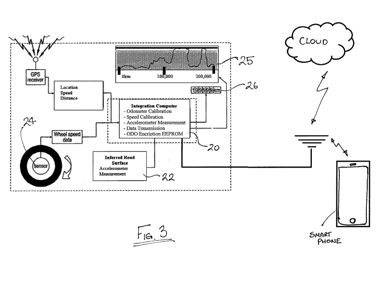
Fig. 3 is a system diagram depicting the components of the present
invention and how they interact;
Fig. 4 is a perspective view of an embodiment of the present invention for
determining wheel revolutions for use in distance calculations;
Fig. 5 is an illustration on an embodiment of a display for the computer of
the present system; and
Fig. 6 is an example service history report capable of being provided in
accordance with an embodiment of the present invention.
DETAILED DESCRIPTION
The present invention will be described below in relation to its application
to a
caravan of the type that is towed by a vehicle. However, it will be
appreciated that
the present invention could be equally employed in any variety of towed
vehicles,
including semi-trailers, recreational vehicles and camper trailers that are to
be
towed by a vehicle and still fall within the scope of the claims of the
present
invention.
Referring to Fig. 1, a caravan 10 is depicted for application of the present
invention
in accordance with an embodiment thereof. The caravan 10 is of a conventional
type and comprises a chassis 14 that supports a body 12. The body 12 forms an
enclosure over the top of the chassis 14 and is configured to function as a
mobile
accommodation space as is well known in the art. A hitch 15 is attached to a
front
end of the chassis 14. The hitch 15 attaches to a tow ball or similar
arrangement
of the towing vehicle (not shown) and may be configured in a variety of
different
ways so as to provide secure attachment to the towing vehicle as well as the
transfer
of control signals from the towing vehicle to the caravan 10 so as to operate
the
turning signals of the caravan 10 and various other functions as would be well
understood by those skilled in the art.
In the embodiment as shown, the chassis 14 is supported above a ground surface
by way of a pair of wheels 16 mounted upon a pair of axles 17 that extend
across
5
CA 03076385 2020-03-19
WO 2019/056048 PCT/AU2018/000185
the chassis 14. Each of the wheels 16 are mounted on opposing ends of the
axles
17 and each of the wheels 16 are free to rotate on the axle 17 under the
towing
force supplied by the towing vehicle.
Whilst not specifically shown, the wheels 16 may be mounted to the chassis by
way of shock absorbers or struts and the axles 17 may comprise independent
suspension systems so as to minimise transferral of undesired forces to the
caravan
to avoid damage to the caravan, especially during traversal across rough
terrain.
Referring to Fig 2, the chassis 14 is depicted in isolation. A computer system
20
is mounted with respect to the caravan 10 and is able to communicate
wirelessly,
or in a wired manner, with a variety of sensors provided on the chassis 14 and
body
12 of the caravan so as to measure and record a variety of functions in
accordance
with the present invention. The computer system 20 may be mounted on an
external wall of the caravan, in the roof of the caravan or inside the
caravan,
depending on the design of the caravan.
An accelerometer 22 is mounted on the body of the chassis 14, to measure axial
movement of the chassis 14 with respect to the road surface. In the embodiment
as shown, the accelerometer 22 is mounted on the central axis of the chassis
14.
However, it will be appreciated that multiple accelerometers 22 may be mounted
at various points of the chassis 14 to measure axial movement of different
regions
of the chassis with respect to the road surface. In other embodiments the
sensors
22, may be mounted at other points on the caravan 10, such as in the
suspension,
floor of the caravan or roof of the caravan. Whilst reference is made to the
sensor
being an accelerometer, it will be appreciated that the sensor could be any
form of
sensor capable of measuring axial movement. The purpose of the sensor 22 is to
provide an indication of the terrain that the caravan 10 is traveling along
such that
the computer 20 is able to categorise the terrain in terms of its impact on
the chassis
14 of the caravan and the suspension of the caravan. This enables road
corrugation
to be categorised in relation to its adverse impact on the shock absorbers of
the
caravan, so that the amount of work the suspension system and the shock
absorbers
have done can be captured. This information can be provided to the driver of
the
towing vehicle via the present system of the invention such that the driver
can pull-
over and stop driving to allow the shock absorbers to cool down before they
enter
a failure mode.
The sensor 22, when mounted on the roof of the caravan 10, may also be used to
indicate the energy absorption characteristics of the caravan. The difference
between the road surface energy measured by the sensor placed on the caravan
6
CA 03076385 2020-03-19
WO 2019/056048 PCT/AU2018/000185
chassis or suspension system and the energy which is measured in the roof of
the
caravan provides an indication of the energy absorbed by the caravan, which is
a
measurement of damage being undertaken by the caravan.
A distance sensor 24 may be mounted within the wheel hub of one or more of the
wheels 16. The distance sensor 24 will be described in more detail below but
functions to detect either partial or full wheel rotation and to transmit the
data to
the computer 20 for recordal and processing. In the embodiment as shown, two
distance sensors 24 are mounted in the hubs of wheels 16, on opposing sides of
the
chassis 14. However, it will be appreciated that the number and location of
the
distance sensors 24 can vary as appreciated by those skilled in the art.
The computer 20 may include a GNSS receiver that provides autonomous geo-
spatial positioning data of the caravan through multiple satellite systems.
The
ability to receive signals from multiple satellite signals provides improved
accuracy over rational GPS and ensures availability and a degree of
redundancy.
This GNSS receiver enables the computer 20 to determine the positional
location
of the caravan at all times and to record such data together with the readings
taken
of the quality of the road surface by the relevant sensors. The computer may
alternatively include a Satellite Based Augmentation System (SBAS) or real
time
kinematic (RTK) system that employ ground stations working in combination with
satellite systems to improve accuracy of the measurement system.
The computer 20 is able to store data as it is received and to align data with
other
received data to provide a multifaceted recordal of each trip made by the
caravan.
The non-volatile and encrypted memory of the computer 20 is able to store
wheel
rotation data received from the distance sensors 24 and road surface readings
received from the sensors 20. This data can then be cross referenced against
the
GNSS data being downloaded in real time, which has the capacity to extrapolate
caravan speed and distance for further comparison and cross-check.
The computer 20 is able to either communicate in a wired or a wireless manner
with each of the sensor systems to enable the system to be readily configured
and
to facilitate connection with a smart phone or the like to download and review
data.
The computer 20 may also comprise a display, such as an LCD for displaying
basic
information such as an odometer reading as well as basic service data
indicating
time/distance until next service is due.
The manner in which the computer 20 is able to configure the data from the
system
is depicted in Fig. 3. As shown, whilst the caravan is in motion, the computer
20
is able to use the data being received by the GNSS receiver to assess speed,
7
CA 03076385 2020-03-19
WO 2019/056048 PCT/AU2018/000185
location and distance travelled. The distance sensor 24 is also constantly
sending
data to the computer 20 measured directly from the wheel(s) 16 of the caravan.
The data supplied by the distance sensor 24, namely the number of wheel
rotations
per a given period of time, can be readily used to calculate the speed and
distance
travelled by the caravan when the dimensions of the wheel are known, which can
be measured against the data received from the GNSS receiver for error
correction
purposes.
The road surface sensor 22 will collect data associated with axial movement of
the
chassis or suspension 14 which can then be processed by the computer 20
through
the application of a dampening mechanism to generate a measurement of road
surface integrity or 'ground truth'. This road surface integrity/ground truth
measurement can then be plotted against distance travelled by the caravan as
is
shown in the plot 25 of Fig. 3. This plot can then be used to provide the user
with
a visual indication of the state of the road and where and for how long the
road
surface condition exceeded acceptable engineering limits and generated chassis
movements outside a safe range. The plot 25 may provide bands to indicate
where
the detected chassis movement is in a safe/acceptable/unacceptable/dangerous
range. The computer may also provide a standard odometer reading of the
combined distance travelled by the caravan in those ranges, as depicted by the
reading 26 in Fig. 3.
One embodiment depicting the manner in which the distance sensor 24 may be
configured to collect rotational information of the wheel 16 of the caravan is
depicted in Fig. 4. This embodiment utilises the existing electric brake
hub
present on the wheel 16, which is fitted with an aftermarket sensor or magnet
30.
In a conventional drum brake the inner drum is fitted with an electro-magnet
30 as
depicted. As the wheel 16 rotates, magnetised wheel studs, magnet/s or
magnetised drum present in the wheel will interact with the electro-magnet 30
to
induce a signal which can be collected by a coil in the brake line. In another
depiction, a magnetic field generated by the electro-magnet could be distorted
by
the passing of wheel studs, magnet/s or magnetised drum, thus, each time the
wheel
rotates the detected signal will be recorded by the computer 20 as a full or
partial
wheel rotation. As the diameter of the wheel 16 is known, the distance can be
readily calculated together with the speed of the wheel. Such a simple means
for
collecting data can be simply and effectively used by the system as a measure
of
distance travelled, as well as speed.
The computer 20 may be located within the caravan 10, with a display of the
computer readily accessible. In a preferred from, the display of the computer
20
8
CA 03076385 2020-03-19
WO 2019/056048 PCT/AU2018/000185
may be configured in the manner as depicted in Fig. 5. The distance travelled
is
depicted in appropriate format 35. In the embodiment as shown, the format is
in
kms although the format may also be displayed in miles if required by the
user. In
this form, the caravan user, or a prospective buyer of the caravan, can
readily see
the physical distance travelled by the caravan.
The computer display may comprise a second display 37 that provides the
user/prospective buyer with an indication of the service history and type of
terrain
covered over the distance travelled. A line graph is depicted having a number
of
circles present thereon. These circles are representative of scheduled service
io intervals for the caravan. Those circles shown in grey depict that the
service was
completed, with the white circle indicating that the service was scheduled but
not
completed. In this regard, an important part of servicing the caravan requires
the
servicing body accessing the computer 20 and completing the service history.
This
provides a user of the caravan important information as to when the next
service
should be scheduled and provides a prospective buyer with service history
information which can be used to determine the state of the caravan.
The second part 37 of the display also provides information about the terrain
travelled by the caravan over the distance, referred to as the ground truth
report.
This is depicted by the line graph as shown, with the upper bars depicting
terrain
where the stresses placed on the chassis of the caravan is in a "caution zone"
and
an "excessive zone" respectively. These zones can be determined based on
make/model/capability of the caravan and are based on the recommended loads to
be applied to the chassis of the caravan as set by the manufacturer. As the
system
of the present invention takes measurements via the accelerometer 22, these
forces
can be collected and recorded over time in a simple and effective manner and
stored as part of the odometer reading. Once again, the user is able to
readily
determine how much work the caravan has done since the last service and if the
caravan has been used in difficult terrain, they may choose to bring that
service
forward if the distance travelled has been in any of these ranges. Similarly,
a
prospective buyer of the caravan is able to obtain an indication of the use of
the
vehicle when assessing the purchase price by entering in the VIN number from
the
caravan to access this information.
It will be possible for a user to interrogate the computer 20 or retrieve
equivalent
data from the internet cloud to obtain a more detailed reading of the service
history
of the caravan. This could be displayed on the computer's screen or may
communicate with a software application installed on a smart phone or similar
electronic device to display the information on the electronic device. Fig. 6
depicts
9
CA 03076385 2020-03-19
WO 2019/056048 PCT/AU2018/000185
an embodiment of a type of report that can be obtained. This report identifies
the
date of the service, the scheduled service and the distance travelled by the
caravan
at each scheduled interval. Additional information indicating the type of work
undertaken and the name of the service provider is also shown.
It will be appreciated that the system and method of the present invention
provides
a simple and effective means for capturing data associated with the use of the
caravan for use in maintaining the caravan and for providing a means for
determining true depreciated value of the caravan based on its actual use. By
providing not only a means for measuring distance travelled by the caravan but
also by providing a means for recording the types of road surfaces that the
caravan
has travelled on, appropriate servicing of the caravan can be undertaken based
on
the strain and stresses that the caravan has been subjected to over its life.
This
information can be used by owners, prospective buyers or aggregated to an
internet
cloud platform for distributed use providing users of caravans with the most
up to
date information at their disposal to make appropriate decisions about the
care and
safety of their caravan.
It will be appreciated that the information collected by the system and method
of
the present invention can be used to on-sell or provide customers with usage
history of the caravan whereby the customer is able to simply visit a web
hosted
site and Enter the VIN details of the caravan or trailer and see the usage
history of
the vehicle. Such information availability will enable manufacturers to gain a
better insight into what owners of off-road caravans really do in their
caravans with
such information being able to be used for warranty purposes. Such information
can also be provided to insurance agencies to determine premiums, and can be
supplied to councils and governments to provide an indication of the condition
of
the roads they are managing and where repairs to the road are required. By
providing access to collected information from all users, customers are able
to use
the information in their trip planners so that they can determine the road
conditions
before directly experiencing them, giving them the option of taking
alternative
routes where desired.
Information will also be made available to drivers of the towing vehicle as
they are
in transit. This provides the driver direct feedback of the towing conditions.
In
this regard, the computer processor will be provided with a database of
maximum
performance standards for the various aspects of the caravan such that when
the
sensors process data in real time that correlates to performance standards
that when
compared to the stored performance standards fall outside the maximum limits,
alerts can be issued to the driver to modify the driver's behaviour.
CA 03076385 2020-03-19
WO 2019/056048 PCT/AU2018/000185
Also, by measuring road condition and the location of those conditions it is
possible to determine a "Road Truth" test standard. This information can be
supplied to chassis manufacturers to ensure that the chassis being constructed
are
capable of withstanding such real road conditions. Similarly, such known road
surface conditions can be used to determine suspension performance and thus
resultant vibration energy transferred to chassis. The metrics of which are
input
into the ODO computer at time of manufacturing based on suspension type
(springs, wheels etc) and ATM, GTM, and ball weight.
Throughout the specification and claims the word "comprise" and its
derivatives
are intended to have an inclusive rather than exclusive meaning unless the
contrary
is expressly stated or the context requires otherwise. That is, the word
"comprise"
and its derivatives will be taken to indicate the inclusion of not only the
listed
components, steps or features that it directly references, but also other
components,
steps or features not specifically listed, unless the contrary is expressly
stated or
the context requires otherwise.
It will be appreciated by those skilled in the art that many modifications and
variations may be made to the methods of the invention described herein
without
departing from the spirit and scope of the invention.
11