Note: Descriptions are shown in the official language in which they were submitted.
TITLE
[0001] Method of avoiding Controlled Flight Into Terrain and a
Controlled Flight Into
Terrain Avoidance System
FIELD
[0002] The present application relates to a method of avoiding
Controlled Flight Into
Terrain and a Controlled Flight Into Terrain Avoidance System in accordance
with the
method.
BACKGROUND
[0003] Every year there are airplane crashes occurring which are termed
"Controlled
Flight Into Terrain" (CFIT) crashes. The airplane literally flies in a
controlled manner into a
hillside. Most often these CFIT crashes occur under conditions of poor
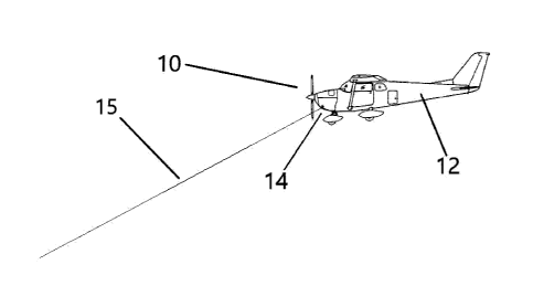
visibility, with the
pilot unaware of the imminent danger until it is too late.
[0004] There have been a number of patents filed which describe systems
intended to
avoid CFIT: U.S. Patent publication 20080262664 (Schnell et al) titled
"Synthetic vision
system and methods"; U.S. Patent publication 20100292871 (Schultz et al)
titled "Adaptive
Surveillance And Guidance System For Vehicle Collision Avoidance And
Interception";
U.S. Patent publication 20100305784 (Anderson et al) titled "Embedded Ground
Proximity
Warning System for Helicopters"; U.S. Patent publication 20160264255 (Connor
et al) titled
"Vehicle Navigation Methods, Systems and Computer Program Products"; U.S.
Patent
publication 20160272340 (Leland et al) titled "Aircraft-Vision Systems And
Methods For
Maintaining Situational Awareness And Spatial Orientation"; U.S. Patent
publication
20170309060 (John) titled "Cockpit Display For Degraded Visual Environment
(DVE)
Using Millimeter Wave Radar (MMWR)".
[0005] The problem of CFIT is particularly acute for aircraft flying
under Visual Flight
Rules (VFR). Often the only option for aircraft flying under VFR is to fly
around a ground
obstacle, as there can be a number of reasons why such aircraft may not have
the option of
pulling up to fly over the ground obstacle. There may be technical limitations
which prevent
an aircraft from pulling up to fly over a ground obstacle. The aircraft may
not have the
1
CA 3077269 2020-03-27
power for the climb required and may not have a pressurized cabin required for
higher
altitudes. There may be weather limitations which prevent an aircraft from
pulling up to
flying over a ground obstacle. For example, there could be low cloud cover,
and the aircraft
flying under VFR is not allowed to fly above the clouds. It is, therefore,
critical that a pilot
flying under VFR received warning in sufficient time to take appropriate
evasive action to
avoid a ground obstacle.
SUMMARY
[0006] According to one aspect there is provided a method of avoiding
Controlled Flight
Into Terrain. The method involves a step of equipping an aircraft with at
least one radar
based sensor positioned in an angular orientation directed forward and down,
so as to detect
ground objects ahead of the aircraft. The radar must have a range of at least
10 Kilometres.
The method involves a step of positioning a dedicated processing unit within
the aircraft. The
processing unit is dedicated to receiving signals solely from the at least one
radar based
sensor. The method involves a step of positioning a dedicated display within
the aircraft. The
display is in communication with the processing unit and is dedicated to
displaying only such
graphics generated by the processing unit. The display has an active mode and
an inactive
mode. The method involves a step of programming the processing unit to monitor
the at least
one radar based sensor and leave the display in an inactive mode until the at
least radar based
sensor detects a ground object meeting predetermined parameters. Upon the at
least radar
based sensor detecting a ground object meeting the predetermined parameters
the processing
unit being programmed to switch the display to the active mode and display a
graphic
representation of the ground object.
[0007] According to another aspect there is provided a CFIT avoidance
system that
includes an aircraft with at least one radar based sensor positioned in an
angular orientation
directed forward and down, so as to detect ground objects ahead of the
aircraft. The radar has
a range of at least 10 Kilometres. A dedicated processing unit is positioned
within the
aircraft. The processing unit is dedicated to receiving signals solely from
the at least one
radar based sensor. A dedicated display is positioned within the aircraft. The
display is in
2
CA 3077269 2020-03-27
communication with the processing unit and is dedicated to displaying only
such graphics as
generated by the processing unit. The display has an active mode and an
inactive mode. The
processing unit is programmed to monitor the at least one radar based sensor
and leave the
display in an inactive mode until the at least radar based sensor detects a
ground object
meeting predetermined parameters. Upon the at least radar based sensor
detecting a ground
object meeting the predetermined parameters, the processing unit is programmed
to switch
the display to the active mode and display a graphic representation of the
ground object.
[0008] It should be noted that the radar must have a range of at least
10 Kilometres.
There is a reason for this. A small airplane, such as a Cessna, flies at
approximately 170
Kilometres per hour. Warning of a ground object within 10 Kilometres will give
the pilot
approximately 3 minute and 30 seconds to take evasive action to avoid the
ground object. If
the radar has a range of less than 10 Kilometres, the pilot of the small
airplane will not have
sufficient time to react. It will be appreciated that if a larger and faster
airplane was equipped
with a CFIT avoidance system, an even greater range would be required. For
example, a
radar detection system with only a 10 Kilometre range would only afford a 50
second
warning of a ground object to a pilot of an airliner travelling at 700
kilometres per hour.
[0009] It should be noted that the processing unit is dedicated to
receiving signals solely
from the at least one radar based sensor. As can be determined from a review
of the prior art
there are certainly other technologies that have been integrated into such
systems and
potentially could be integrated into the CFIT system. However, this is
considered highly
undesirable. One concern is that signal delays waiting for Global Positioning
System (GPS)
confirmation will create a time delay which will further reduce that
relatively short warning
that a pilot receives. Another concern is that adjustments to sensor results
required when
other technologies (such as GPS and terrain maps) are integrated could
introduce
inaccuracies. This CFIT system was developed for use Northern Canada. In many
areas of
Northern Canada GPS is not reliable and terrain maps are outdated or non-
existent.
[0010] It should be noted that the display is left in an inactive mode
until the at least
3
CA 3077269 2020-03-27
radar based sensor detects a ground object meeting predetermined parameters.
Upon the at
least radar based sensor detecting a ground object meeting the predetermined
parameters the
processing unit being programmed to switch the display to the active mode. The
reason for
this is that a display that is always active tends to blend into the other
instrumentation. The
CFIT avoidance system is a warning system. When it becomes active, the pilot
only has
approximately 3 minutes and 30 seconds to react. As will be hereinafter
described, it is
preferred that the display be in the form of "augmented reality glasses", so
that the change to
active status is immediately brought to the pilots attention and cannot be
inadvertently
overlooked. If a display other than "augmented reality glasses" were to be
used, it would be
important to bring the change in status to the attention of the pilot by
having an alarm state
indication with a flashing light, an auditory tone or a vibrating element.
BRIEF DESCRIPTION OF THE DRAWINGS
[0011] These and other features will become more apparent from the
following
description in which reference is made to the appended drawings, the drawings
are for the
purpose of illustration only and are not intended to be in any way limiting,
wherein:
[0012] FIG. 1 is a schematic diagram of components of a CFIT avoidance
system in
accordance with the teachings of the method.
[0013] FIG. 2 is atop plan view of an airplane equipped with the CFIT
avoidance system
of FIG. 1.
[0014] FIG. 3 is a side elevation view of an airplane equipped with the
CFIT avoidance
system of FIG. 1.
[0015] FIG. 4 is a graphic representation of an active display.
DETAILED DESCRIPTION
[0016] A method of avoiding Controlled Flight Into Terrain (CFIT) and a
CFIT
Avoidance System, generally identified by reference numeral 10, will now be
described with
reference to FIG. 1 through FIG. 4.
4
CA 3077269 2020-03-27
Structure and Relationship of Parts:
[0017] Referring to FIG. 3, CFIT avoidance system 10 includes an
aircraft 12 with
at least one radar based sensor 14 positioned in an angular orientation
directed forward
and down as shown by reference numeral 15. It will be understood that there
may be one
of more radar based sensor 14. Hereinafter, there will reference to one radar
based
sensor, it being understood that they may be more than one to provide the
coverage
desired. Radar based sensor 14 must have a range of at least 10 Kilometres.
The exact
range depends upon the cruising speed of aircraft 12 and is intended to allow
the pilot of
aircraft 12 sufficient time to react. For example, a small airplane, such as a
Cessna, flies
at approximately 170 Kilometres per hour. Warning of a ground object within 10
Kilometres will give the pilot approximately 3 minute and 30 seconds to take
evasive
action to avoid the ground object.
[0018] Referring to FIG. 1, the other components of CFIT avoidance
system 10 are
illustrated. There is a dedicated processing unit 18 within aircraft 12.
Processing unit 18
is dedicated to receiving signals solely from radar based sensor 14. There is
a dedicated
display, shown as taking the form of "augmented reality glasses" 20, within
aircraft 12.
Augmented reality glasses 20 are in communication with processing unit 18 and
are
dedicated to displaying only such graphics generated by processing unit 18. As
will
hereinafter described, augmented reality glasses 10 have an active mode and an
inactive
mode.
[0019] Referring to FIG. 1, processing unit 18 is programmed to monitor
radar based
sensor 14 (shown in FIG. 2 and FIG. 3) and leave the augmented reality glasses
20 in an
inactive mode until radar based sensor 14 (shown in FIG. 2 and FIG. 3) detects
a ground
object meeting predetermined parameters. Upon radar based sensor 14 (shown in
FIG.
2 and FIG. 3) detecting a ground object meeting the predetermined parameters,
processing unit 18 is programmed to switch augmented reality glasses 20 to the
active
mode and display a graphic representation of the ground object.
5
Date Recue/Date Received 2020-09-15
[0020] Referring to FIG. 1, display area 22 of augmented reality
glasses 20 remains
transparent when in the inactive mode. The only indication that the user will
have in the
inactive mode will be a small indicator light providing confirmation that
augmented
reality glasses are operational. However, when augmented reality glasses 20
are in the
active mode, a graphic representation of the ground object detected will be
displayed in
display area 22. It is preferred that processing unit 18 have a wireless
transmitter 24 for
the purpose of communicating with augmented reality glasses 20. Augmented
reality
glasses 20 have a wireless receiver 26 and an associated antenna 28.
[0021] In order to ensure that an alarm condition is not inadvertently
overlooked by
the pilot, processing unit 18 there are additional features that may
incorporated into
processing unit 18 or connected to processing unit 18. These features will
collectively
be referred to as the "alarm". It will be understood that any one of all of
the features may
be included. The alarm includes a flashing light 30 to provide a visual
signal, a tone
emitter/speaker 32 to provide an auditory signal and a vibrator 34 (attached
to augmented
reality glasses 20) to provide a tactile sensory signal. As described above
with
augmented reality glasses 20, the components of alarm have an active mode and
an
inactive mode. Processing unit 18 is programmed to monitor radar based sensor
14
(shown in FIG. 2 and FIG. 3) and leave the alarm in an inactive mode until the
at least
radar based sensor detects a ground object meeting predetermined parameters.
Upon
radar based sensor (shown in FIG. 2 and FIG. 3) detecting a ground object
meeting the
predetermined parameters, processing unit 18 switches the alarm to the active
mode,
whereupon flashing light 30 flashes to provide a visual signal, tone
emitter/speaker 32
emits a tone to provide an auditory signal and vibrator 34 (attached to
augmented reality
glasses 20) causes augmented reality glasses 20 to vibrate providing a tactile
sensory
signal.
Operation:
[0022] Referring to FIG. 2, radar based sensor 14 performs a sensing
function during
the flight of aircraft 12. During normal flight there will not be any ground
objects within
area 16 that defmes the area that radar based sensor 14 covers. That means
that during
normal flight augmented reality glasses 20 will remain in the inactive mode
and display
area 22 of augmented reality glasses 20 will remain transparent. That also
means that
the various alarm features will remain inactive.
6
Date Recue/Date Received 2020-09-15
[0023] Referring to FIG. 2, a change in the weather may create a
low cloud cover.
This may force a pilot flying under Visual Flight Rules (VFR) to fly lower to
the ground
than normal, relying upon CFIT system 10. Should a ground object be sensed by
radar
based sensor 14 within area 16, processing unit 18 immediately switches
augmented
reality glasses 20 to the active mode and displays a graphic representation of
the ground
object detected in display area 22 of augmented reality glasses 20.
Concurrently,
processing unit 18 switches the alarm features to the active mode, causing
flashing light
30 to flash to provide a visual signal, tone emitter/speaker 32 to emit a tone
to provide an
auditory signal and vibrator 34 (attached to augmented reality glasses 20) to
cause
augmented reality glasses 20 to vibrate providing a tactile sensory signal.
[0024] Referring to FIG. 4, there is illustrated an example of what
display area 22 of
augmented reality glasses 20 might look like when switched by processing unit
18 to
"active" mode. There are some points to be noted about this active version of
display
area 22. The background is transparent on augmented reality glasses 20. The
dark
background in FIG. 4, is intended to represent the transparent background on
augmented
reality glasses 20. It is important that the background not be a blockage of
pilot's vision.
The image should be consider as "augmented" reality. "Augmented" reality is a
technology that superimposes a computer-generated image on a user's view of
the real
world through glasses 20, thus providing a composite view. Grid lines are
provided for
horizontal and vertical reference. The horizontal grid line represents the
horizon of
aircraft 12. Each ground obstacle is displayed by a full circle, surrounded by
a thin circle
line and a triangle (symbol of warning or a mountain). The size of the circles
and
triangles is proportional to the size of the ground obstacle (as determined by
the signal
strength received by the radar). The location on the display of the ground
obstacles are
in the same direction as the pilot is looking over the front aircraft window
(but can't see
them because of fog/night or other obstructions). This makes this type of
display very
intuitive. Attached to the top corner of the triangle there is a number which
represents
the distance to the ground object. This can be expressed in miles with the
notation "mi"
(in the example "m" has been used) or Kilometres with the notation "Km" or any
other
units, as long as there is a notation to confirm units so as to avoid any
confusion. One
can also colour code the ground obstacles, with the colour indicating the
danger level.
7
Date Recue/Date Received 2020-09-15
aircraft window (but can't see them because of fog/night or other
obstructions). This makes
this type of display very intuitive. Attached to the top corner of the
triangle there is a number
which represents the distance to the ground object. This can be expressed in
miles with the
notation "mi" (in the example "m" has been used) or Kilometres with the
notation "Km" or
any other units, as long as there is a notation to confirm units so as to
avoid any confusion.
One can also colour code the ground obstacles, with the colour indicating the
danger level.
Cautionary Warnings:
[0025] It is to be noted that the range of the radar must be matched
to suit the speed of
aircraft 12. Radar with a range of 10 kilometres will provide a pilot of a
small aircraft
travelling at 170 kilometres per hour approximately three minutes and 30
seconds to react.
When aircraft 12 has a faster cruising speed, the range of the radar must be
increased to
provide sufficient time to take evasive action. An aircraft that has a
pressurized cabin and
can climb over ground objects may not need as much time as an aircraft
operating under VFR
that must change course to go around the ground object.
[0026] In this patent document, the word "comprising" is used in its
non-limiting sense to
mean that items following the word are included, but items not specifically
mentioned are not
excluded. A reference to an element by the indefinite article "a" does not
exclude the
possibility that more than one of the element is present, unless the context
clearly requires
that there be one and only one of the elements.
[0027] The scope of the claims should not be limited by the illustrated
embodiments set
forth as examples, but should be given the broadest interpretation consistent
with a purposive
construction of the claims in view of the description as a whole.
8
CA 3077269 2020-03-27