Note: Descriptions are shown in the official language in which they were submitted.
CA 03077523 2020-03-30
METHOD, DEVICE, AND EQUIPMENT FOR OBSTACLE OR GROUND
RECOGNITION AND FLIGHT CONTROL, AND STORAGE MEDIUM
CROSS-REFERENCE TO RELATED APPLICATION
This application claims priority to Chinese patent application No.
201810931105.7 filed on
August 15, 2018 by GUANGZHOU XA1RCRAFT TECHNOLOGY CO., LTD., with a title of
"METHOD, DEVICE, AND EQUIPMENT FOR OBSTACLE OR GROUND RECOGNITION
AND FLIGHT CONTROL, AND STORAGE MEDIUM ".
TECHNICAL FIELD
The present disclosure relates to aircraft technologies, and more particularly
to a method, a
device, an equipment for obstacle or ground recognition and flight control,
and a medium.
BACKGROUND
With the popularity of aircrafts, more and more people are beginning to know
and use
aircrafts. At present, civil aircrafts are mainly divided into consumer-class
aircrafts and
industry-class (profession-class) aircrafts. These two types of aircrafts are
usually under manual or
automatic control, to accurately control the aircraft to complete some flight
tasks. These flight
tasks include spraying operations, aerial photography, line patrol,
reconnaissance survey,
measurement, cargo delivery and so on.
During the operation of the aircraft, the detection device at the bottom of
the aircraft may be
used to keep the aircraft at a set distance from the ground, thereby realizing
terrain simulation
flying, and the detection device in the front of the aircraft is used to
determine whether there is an
obstacle in front of the aircraft. When it is recognized that an obstacle is
present in front of the
aircraft, the obstacle avoidance operation is performed.
However, during the flying of the aircraft, when it is determined by the
detection device in the
front of the aircraft that a slope of the ground in front of the aircraft is
within a set range, the
aircraft may treat it as an obstacle to perform the obstacle avoidance
operation, although the
aircraft may perform the terrain simulation flying. Therefore, since the
aircraft cannot accurately
recognize the obstacle or ground in front of the aircraft, it leads to
conflicts between the terrain
simulation flying and the obstacle avoidance operation, which affects work
process and work
1
PI0E3193519PCA
CA 03077523 2020-03-30
efficiency.
SUMMARY
The present disclosure provides a method, a device, and an equipment for
obstacle or ground
recognition and flight control, and a medium, which may accurately recognize
the obstacle or
ground in the region in front of the aircraft, thereby improving work
efficiency of the aircraft.
In a first aspect, a method for obstacle or ground recognition is provided by
the present
disclosure. The method includes: determining point cloud data of a region in
front of an aircraft;
dividing the front region into several subregions, and determining an altitude
of each of the
subregions according to the point cloud data in each of the subregions; and
performing linear
fitting on the altitudes of the several subregions, and determining whether an
obstacle and/or
ground is present in the front region according to a fitting result.
Performing linear fitting on the altitudes of the several subregions includes:
performing the
linear fitting with a horizontal distance between the aircraft and each of the
subregions as an
abscissa and with the altitude of each of the subregions as an ordinate.
Determining whether an obstacle and/or ground is present in the front region
based on the
fitting result includes: when the slope of the fitted line is less than a
slope threshold, and the mean
square error of the fitted line is less than an error threshold, determining
that the ground is present
in the front region; otherwise, determining that an obstacle is present in the
front region.
Performing linear fitting on the altitudes of the several subregions includes:
performing a
piecewise linear fitting with a horizontal distance between the aircraft and
each of the subregions
as an abscissa and with the altitude of each of the subregions as an ordinate.
Determining whether an obstacle and/or ground is present in the front region
based on the
fitting result includes: determining an average value of the slopes of the
lines generated from
piecewise linear fitting; if the difference between the slope of each of the
lines generated from
piecewise linear fitting and the average value is less than a first set value,
the average value is less
than the slope threshold, and the mean square error of each of the lines
generated from piecewise
linear fitting is less than a second set value, determining that the ground is
present in the front
region; otherwise, determining that the obstacle is present in the front
region.
Dividing the front region into several subregions includes: equidistantly
dividing the front
region into the subregions arranged in order along the heading of the
aircraft.
2
PI0E3193519PCA
CA 03077523 2020-03-30
Determining the altitude of each of the subregions based on the point cloud
data in each of the
subregions includes: storing the point cloud data into arrays of the
respective subregions; for each
subregion, removing a set number of point cloud data from the array of the
subregion based on a
descending order of altitudes; determining an average altitude based on the
remaining point cloud
data in the array; and taking the average altitude as the altitude of the
subregion.
Determining the altitude of each of the subregions based on the point cloud
data in each of the
subregions includes: storing the point cloud data into arrays of the
respective subregions; for each
subregion, determining an average altitude based on all point cloud data in
the array; and taking
the average altitude as the altitude of the subregion.
Before storing the point cloud data into arrays of the respective subregions,
the method
further includes: performing a downsampling processing on the point cloud
data.
The method further includes: determining the region in front of the aircraft
based on a preset
route of the aircraft, a position of the aircraft and a width of the aircraft,
in which, the horizontal
distance from each point in the front region to the aircraft is within a first
set distance range, and
the vertical distance from each point in the front region to the aircraft is
within a second set
distance range.
Determining point cloud data of the region in front of the aircraft, includes:
determining point
cloud data of a detection region of the aircraft, and filtering out the point
cloud data outside the
front region to obtain the point cloud data of the region in front of the
aircraft, in which the
.. detection region is an effective detection range of the aircraft.
In a second aspect, a method for flight control is also provided by the
present disclosure. The
method includes: determining point cloud data of a region in front of an
aircraft; dividing the front
region into several subregions, and determining an altitude of each of the
subregions based on the
point cloud data in each of the subregions; performing linear fitting on the
altitudes of the several
subregions, and determining whether an obstacle and/or ground is present in
the front region based
on a fitting result; and controlling the aircraft to perform an obstacle
avoidance operation if the
obstacle is present in the front region, and controlling the aircraft to
perform a terrain simulation
flying if the ground is present in the front region.
In a third aspect, a device for obstacle or ground recognition is also
provided by the present
disclosure. The device includes: a point cloud data determining module,
configured to determine
point cloud data of a region in front of an aircraft; an altitude determining
module, configured to
3 PI0E3193519PCA
CA 03077523 2020-03-30
divide the front region into several subregions, and determine an altitude of
each of the subregions
based on the point cloud data in each of the subregions; and an obstacle
determining module,
configured to perform linear fitting on the altitudes of the several
subregions, and determine
whether an obstacle and/or ground is present in the front region according to
a fitting result.
In a fourth aspect, a device for flight control is also provided by the
present disclosure. The
device includes: a point cloud data determining module, configured to
determine point cloud data
of a region in front of an aircraft; an altitude determining module,
configured to divide the front
region into several subregions, and determine an altitude of each of the
subregions based on the
point cloud data in each of the subregions; an obstacle determining module,
configured to perform
linear fitting on the altitudes of the several subregions, and determine
whether an obstacle and/or
ground is present in the front region according to a fitting result; and a
flight control module,
configured to control the aircraft to perform an obstacle avoidance operation
if the obstacle is
present in the front region, and control the aircraft to perform a terrain
simulation flying if the
ground is present in the front region.
In a fifth aspect, an equipment is also provided by the present disclosure.
The equipment
includes a memory, a processor, and a computer program stored on the memory
and executable on
the processor. The program is configured to, when executed by the processor,
cause the processor
to carry out the method for obstacle or ground recognition, or the method for
flight control
provided by the present disclosure.
In a sixth aspect, a computer-readable storage medium is also provided by the
present
disclosure. The computer-readable storage medium has stored a computer program
thereon. The
program is configured to, when executed by a processor, carry out the method
for obstacle or
ground recognition, or the method for flight control provided by the present
disclosure.
In the present disclosure, the region in front of the aircraft is divided into
several subregions,
point cloud data of the region in front of the aircraft is matched to the
corresponding subregion,
and the altitude of subregion is determined on the basis of the point cloud
data in the subregion,
and linear fitting is performed on the altitudes of the several subregions, so
that it is determined
whether an obstacle and/or ground is present in the front region on the basis
of the fitting result.
The obstacle or ground in front of the aircraft can be accurately recognized,
thereby avoiding
conflicts between the terrain simulation flying and obstacle avoidance
operation, thereby
improving work efficiency.
4
PI0E3193519PCA
CA 03077523 2020-03-30
BRIEF DESCRIPTION OF THE DRAWINGS
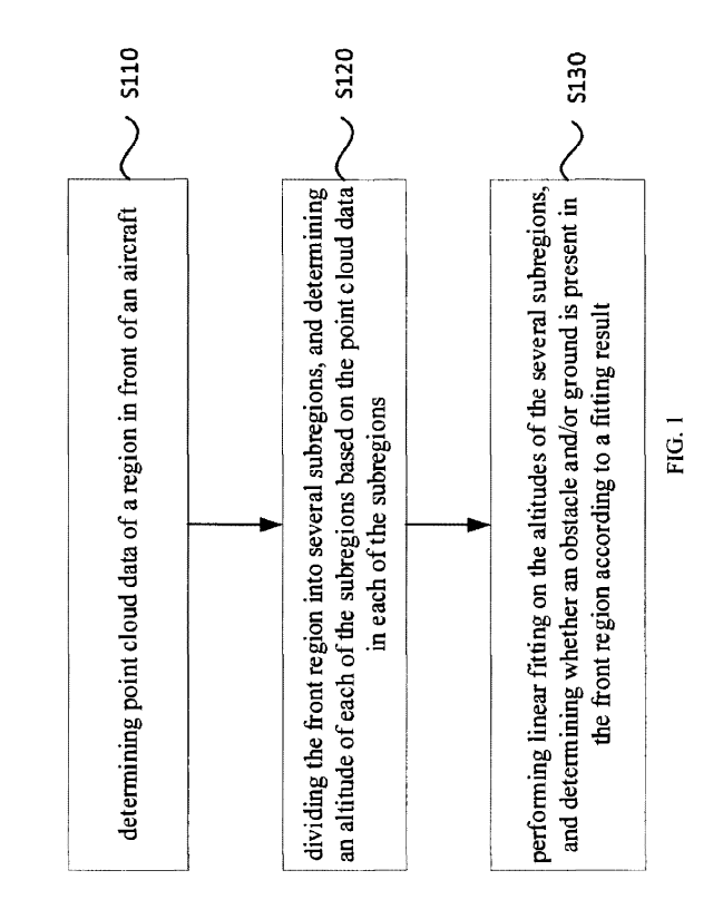
FIG. 1 is a flowchart of a method for obstacle or ground recognition provided
by the present
disclosure;
FIG. 2 is a top view of a longitudinally divided region in front of an
aircraft provided by the
present disclosure;
FIG. 3 is a flowchart of another method for obstacle or ground recognition
provided by the
present disclosure;
FIG. 4 is a flowchart of further another method for obstacle or ground
recognition provided
by the present disclosure;
FIG. 5 is a flowchart of yet another method for obstacle or ground recognition
provided by
the present disclosure;
FIG. 6 is a flowchart of yet another method for obstacle or ground recognition
provided by
the present disclosure;
FIG. 7 is a flowchart of a method for flight control provided by the present
disclosure;
FIG. 8 is a block diagram of a device for obstacle or ground recognition
provided by the
present disclosure;
FIG. 9 is a block diagram of a device for flight control provided by the
present disclosure;
FIG. 10 is a schematic diagram of an equipment provided by the present
disclosure.
DETAILED DESCRIPTION
The present disclosure is further described in detail below in conjunction
with the
accompanying drawings. It may be understood that what is described herein is
only used to explain
the present disclosure, rather than limiting the present disclosure. It should
also be noted that, for
the convenience of description, only some parts related to the present
disclosure are shown in the
drawings instead of the whole structure.
FIG. 1 is a flowchart of a method for obstacle or ground recognition provided
by the present
disclosure. The method for obstacle or ground recognition is performed by a
device for obstacle or
ground recognition, which is implemented in software and/or hardware. The
device for obstacle or
ground recognition may be configured in the aircraft, and may also be
configured in a device that
may communicate with the aircraft, for example, a terminal, a server, or the
like. The terminal may
5
PI0E3193519PCA
CA 03077523 2020-03-30
be a smart phone, a tablet computer, a smart remote control, or the like. The
server may be a cloud
server or other type of server. The aircraft may be a drone, wherein the drone
may be a plant
protection drone.
The method provided by the present disclosure may be applied to a scenario
where a
suspected obstacle is detected to be present in a region in front of an
aircraft, and in particular to a
scenario where a suspected obstacle is detected to be present in a region in
front of an aircraft
when the aircraft performs works such as spraying, aerial photography and
cruising on the plants.
Among them, the suspected obstacle may be understood as being an actual
obstacle or not. For
example, when a ramp is present in the region in front of the aircraft, and
the slope of the ramp is
within a certain range, the aircraft may detect the ramp as the suspected
obstacle by a detection
device.
In the related art, the ramp is regarded as an actual obstacle by the
aircraft, such that obstacle
avoidance operation is performed. However, the slope of the ramp is not too
large, and the aircraft
might have performed the terrain simulation flying. However, since the ramp is
regarded as the
.. actual obstacle by the aircraft, the obstacle avoidance operation is
actually performed. Therefore,
the method for recognizing the obstacle or ground in the region in front of
the aircraft in the
related art is not suitable, which easily leads to conflicts between the
terrain simulation flying and
obstacle avoidance operation. The method provided by the present disclosure
may further
recognize the obstacle or ground in the region in front of the aircraft,
thereby avoiding conflicts
between the terrain simulation flying and obstacle avoidance operation.
As illustrated in FIG. 1, the technical solution provided by the present
disclosure includes
followings.
At block S110, point cloud data of a region in front of an aircraft is
determined.
In the present disclosure, the aircraft may be a drone, or other types of
aircrafts. The drone
.. may be a plant protection drone.
During the flying of the aircraft, the region in front of the aircraft may be
detected by the
detection device, so that the obstacle and/or ground in the region in front of
the aircraft is
determined. The detection device may include, but is not limited to, a multi-
line LIDAR, a
binocular ranging sensor, a depth image (RGB-D) ranging sensor and the like.
The detection
device may be installed in the front of the aircraft The detection device may
be turned on and off
on the basis of actual working conditions. For example, when the aircraft is
initiated, the detection
6 PI0E3193519PCA
CA 03077523 2020-03-30
device may be turned on, and when the aircraft completes the working task, the
detection device
may be turned off. The detection device may also be used together with other
sensing devices, for
example, the detection device may be turned on when a complex scenario is
detected by other
sensing devices.
During the flying of the aircraft, raw data of the region in front of the
aircraft may be obtained
by the detection device, and the point cloud data of the front region may be
calculated from the
raw data. For example, when the multi-line LIDAR is used for detection, the
distance from an
object to the aircraft may be detected by the multi-line LIDAR. Position
information for each point
on the object may be determined based on the distance from the object to the
aircraft, the angle of
the detection beam emitted by the LIDAR and the position of the aircraft. The
position information
for each point on the object may include latitude and longitude coordinates as
well as the height of
the object. The position information for each point on the object may also be
converted to the body
coordinate system through coordinate conversion, such that the position
information for each point
on the object in the body coordinate system is determined. The horizontal
plane of the centerline
axis of the fuselage may be a plane coordinate system including X and Y axes
and the vertical
plane may be used as Z axis to obtain the body coordinate system. The point
cloud data is formed
by the position information for each point on the object. The raw data may be
the angle of the
scanning beam emitted by the LIDAR, the distance between the aircraft and the
object detected by
the scanning beam, and the like.
For another example, if an RGB-D ranging sensor is used for detection, the
distance between
each point on the object in the front region and the aircraft may be
determined according to a depth
of the captured image, and the conversion relationship between the pixel
coordinate system and the
body coordinate system may be obtained according to the installation position
and angle of the
RGB-D ranging sensor on the aircraft. On the basis of the pixel coordinate of
each point on the
object in the image, the distance between each point on the object and the
aircraft, and the
conversion relationship between the pixel coordinate system and the body
coordinate system, each
point on the object may be mapped into the body coordinate system. The raw
data may be depth
information of the captured image, the installation position and angle of the
RGB-D ranging sensor
on the aircraft, and the like.
Before determining the point cloud data of the region in front of the
aircraft, the method
further includes: determining the region in front of the aircraft based on a
preset route of the
7
PIOE3193519PCA
CA 03077523 2020-03-30
aircraft, a position of the aircraft, and a width of the aircraft, in which
the horizontal distance from
each point in the front region to the aircraft is within a first set distance
range, and the vertical
distance from each point in the front region to the aircraft is within a
second set distance range.
Therefore, the front region may be a space region. When the obstacle or ground
recognition is
performed, the front region may be mapped into a two-dimensional map, and the
information such
as colors may be used to characterize the altitude of the obstacle or each
point of the ground in the
front region, which facilitate processing data, in which the body coordinate
system, the world
coordinate system, or other coordinate systems may be used as a coordinate
system of the
two-dimensional map.
During the flying of the aircraft, more point cloud data in front of the
aircraft may be detected
by the detection device in the front of the aircraft, but only obstacles in
the region in front of the
aircraft may affect the flying of the aircraft. Alternatively, determining
point cloud data of the
region in front of the aircraft includes: determining the point cloud data of
the detection region of
the aircraft, and filtering out the point cloud data outside the front region
to obtain the point cloud
data of the region in front of the aircraft, in which the detection region is
an effective detection
range of the aircraft. The front region may be understood as the working
region in front of the
aircraft. The front region may be obtained by taking the position of the
aircraft as a center, the
width of the aircraft as the lateral width, and the route of the aircraft as
an extending direction of
the width. The horizontal distance from each point in the front region to the
aircraft is within the
first set distance range, and the vertical distance from each point in the
front region to the aircraft
is within the second set distance range. When filtering out the point cloud
data is performed, the
point cloud data outside the front region may be filtered out to obtain the
point cloud data in the
front region. By removing the point cloud data outside the front region and
remaining the point
cloud data in the front region, the amount of data processing may be reduced
and the efficiency of
recognition may be improved.
At block S120, the front region is divided into several subregions, and the
altitude of each of
the subregions is determined according to the point cloud data in each of the
subregions.
Dividing the front region into several subregions may include equidistantly
dividing the front
region into several subregions. That is, the front region may be equidistantly
divided into the
.. subregions arranged in order along the heading of the aircraft. FIG. 2 is a
top view of a
longitudinally divided region in front of an aircraft. As illustrated in FIG.
2, the widths of
8
PI0E3193519PCA
CA 03077523 2020-03-30
respective subregions 102 in the front region 101 of the aircraft 100 are the
same, in which the
subregions 102 are arranged in order along the heading of the aircraft.
In this step, the obtained point cloud data of the region in front of the
aircraft is matched to
the corresponding subregion, and the altitude of each of the subregions is
determined on the basis
of the point cloud data in the subregion. Determining the altitude of each of
the subregions on the
basis of the point cloud data in each of the subregions may include: storing
the point cloud data
into arrays of the respective subregions; for each subregion, removing a set
number of point cloud
data from the array of the subregion based on a descending order of altitudes;
determining an
average altitude on the basis of the remaining point cloud data in the array;
and taking the average
altitude as the altitude of the subregion.
The set number may be a value of 1, 2, 3 or the like, which has a certain
upper limit. The
array of each subregion may be an ordered dynamic array. When the point cloud
data is stored into
the array of the corresponding subregion, the array orders the point cloud
data on the basis of the
altitudes. The point cloud data with the altitude greater than a set altitude
value in the subregion
may also be removed, and an average altitude of the subregion is determined
based on the
remaining point cloud data and used as the altitude of the subregion. For
example, n point cloud
data may be sequentially removed based on the descending order of altitudes;
and the average
altitude is calculated based on the remaining point cloud data and used as the
altitude of the
subregion. Alternatively, a certain amount of point cloud data may be selected
from the remaining
point cloud data based on the descending order of altitudes, and the average
altitude may be
calculated based on the selected point cloud data and used as the altitude of
the subregion.
Therefore, by removing the abnormal point cloud data and calculating the
altitude based on
the remaining point cloud data, the inaccurate point cloud data may be removed
and the altitude of
the subregion may be accurately obtained, so that the obstacle or ground is
accurately recognized.
For example, during the flying of the aircraft, in the case where the image is
captured by the depth
image sensor and the point cloud data of the region in front of the aircraft
is calculated, as the sky
texture in the image is not accurately recognized when the sky in the front
region is captured by
the depth image sensor, it is easy to calculate the point cloud data based on
the image data of the
sky in the image and take this point cloud data as the point cloud data of the
obstacle or ground in
the region in front of the aircraft, resulting in abnormal point cloud data.
Therefore, as the sky's
position is higher but is not an obstacle in the front region, the abnormal
point cloud data in the
9 PI0E3193519PCA
CA 03077523 2020-03-30
image should be removed, that is, the point cloud data with abnormal (higher)
altitude should be
filtered out, thereby ensuring accurate calculation of the altitude of the
subregion. The abnormal
situation of the point cloud data is not limited to the above-mentioned
situation.
It should be noted that, the method for calculating the altitude of the
subregion is not limited
to the above-mentioned method, and point cloud data may also be selected as
required for
calculating the altitude of the subregion. For example, determining the
altitude of each of the
subregions on the basis of the point cloud data in each of the subregions may
further include:
storing the point cloud data into the array of the corresponding subregion;
determining the average
altitude on the basis of all point cloud data in the array; and taking the
average altitude as the
altitude of the subregion. That is, the average altitude of the subregion may
be determined on the
basis of all point cloud data in the subregion and used as the altitude of the
subregion.
It should be noted that, when the front region is divided, the equidistant
division may not be
performed. When the front region is equidistantly divided, the calculation
efficiency may be
improved when performing calculation using the point cloud data within the
subregion.
It should be noted that, in FIG. 2, the region in front of the aircraft is
exemplarily divided into
rectangular subregions, but this is only one example of the present
disclosure. In the present
disclosure, the shape of subregions may also be square, trapezoidal, semi-
circular, or other shapes.
However, it may facilitate calculating and improving calculation efficiency
when the shape of the
subregion is rectangular.
At block S130, linear fitting is performed on the altitudes of the several
subregions, and it is
determined whether an obstacle and/or ground is present in the front region
based on the fitting
result.
In this step, linear fitting of the altitudes of the several subregions may be
the fitting of the
altitudes of several subregions into a straight line. In a set coordinate
system, the positions of the
several subregions may be determined, and the altitudes of the several
subregions may also be
determined. The altitudes of the respective subregions may be fitted into a
straight line, and the
= obstacle and/or ground in the region in front of the aircraft may be
determined according to the
characteristics of the fitted straight line. The specific fitting method and
determining method will
be described in detail below. In the present disclosure, the region in front
of the aircraft is divided
into several subregions, the obtained point cloud data of the region in front
of the aircraft is
matched to the corresponding subregion, and the altitude of the subregion is
determined on the
10
PI0E3193519PCA
CA 03077523 2020-03-30
basis of the point cloud data in the subregion, and linear fitting of the
altitudes of the several
subregions is performed, so that the obstacle and/or ground in the region in
front of the aircraft is
recognized on the basis of the fitting result, which may accurately recognize
the obstacle or ground
in front of the aircraft, thereby avoiding conflicts between the terrain
simulation flying and the
obstacle avoidance operation, thereby improving work efficiency.
FIG. 3 is a flowchart of a method for obstacle or ground recognition provided
by the present
disclosure, where the altitudes of the several subregions are directly fitted.
As illustrated in FIG. 3,
the technical solution provided by the present disclosure includes followings.
At block S210, point cloud data of a region in front of an aircraft is
determined.
At block S220, the front region is divided into several subregions, and the
altitude of each of
the subregions is determined based on the point cloud data in each of the
subregions.
At block S230, a linear fitting is performed with a horizontal distance
between the aircraft
and each of the subregions as an abscissa and with the altitude of each of the
subregions as an
ordinate.
In this step, the horizontal distance between the aircraft and each of the
subregions may be
understood as the horizontal distance from the aircraft to the center of each
of the subregions, and
may also be understood as the horizontal distance from the aircraft to the set
position of each of
the subregions.
In this step, a least square method may be used for linearly fitting, and of
course, other
methods may also be used for linearly fitting. For example, the horizontal
distance between each
of the subregions and the aircraft is taken as the abscissa, and the altitude
of the subregion is taken
as the ordinate, and thus a linear equation may be listed.
The coordinate of the first subregion is (xi, yi), the coordinate of the
second subregion is (x2,
y2), and so on, the coordinate of the n-th small region is (x5, y5).
x2 ..
Let A(a, b) , Xix1 xn )
, Y-- (311, y2 ............................................................ ,
y5), A=YXT(XXT)-1 is
1 1 I
obtained using the least squares method, where the mean square error is 1
=(Y¨AX)(Y¨AX)T .
On the basis of the above method, the slope of the fitted line may be
calculated, and the mean
square error of the fitted line may also be calculated.
At block S240, it is determined whether the slope of the fitted line is less
than a slope
11 PI0E3193519PCA
CA 03077523 2020-03-30
threshold and whether the mean square error of the fitted line is less than an
error threshold.
If yes, S250 is performed; if no, S260 is performed.
At block S250, it is determined that the ground is present in the front
region.
At block S260, it is determined that that an obstacle is present in the front
region.
In the present disclosure, the mean square error is used to evaluate the
fitting degree of the
altitude of the subregion. The smaller the mean square error, the better the
fitting degree of the
altitude of the subregion. When the slope of the fitted line is less than the
slope threshold, and the
mean square error of the fitted line is less than the error threshold, it is
determined that the ground
is present in the front region; otherwise, it is determined that an obstacle
is present in the front
region, in which the ground includes a plane or a ramp with a slope less than
the set value.
It should be noted that if the slope of the ramp in the region in front of the
aircraft is greater
than the set value, the ramp is treated by the aircraft as an obstacle, so
that obstacle avoidance
operation may be performed to ensure normal flight.
Therefore, by determining the obstacle or ground in the region in front of the
aircraft based on
the slope and the mean square error of the fitted line, whether the obstacle
or ground is present in
the front region may be accurately recognized.
FIG. 4 is a method for obstacle or ground recognition provided by the present
disclosure,
where a piecewise linear fitting is performed on the altitudes of the several
subregions. As
illustrated in FIG. 4, the technical solution provided by the present
disclosure includes followings.
At block S310, point cloud data of a region in front of an aircraft is
determined.
At block S320, the front region is divided into several subregions, and the
altitude of each of
the subregions is determined based on the point cloud data in each of the
subregions.
At block S330, a piecewise linear fitting is performed with a horizontal
distance between the
aircraft and each of the subregions as an abscissa and with the altitude of
each of the subregions as
an ordinate.
In this step, the horizontal distance between the aircraft and each of the
subregions may be
understood as the horizontal distance from the aircraft to the center of each
of the subregions, and
may also be understood as the horizontal distance from the aircraft to the set
position of each of
the subregions.
The piecewise linear fitting may be dividing all subregions into a number of
parts, and
12 PI0E3193519PCA
CA 03077523 2020-03-30
performing a linear fitting for each part with the horizontal distance between
the aircraft and the
subregion as the abscissa and with the altitude of the subregion as the
ordinate, which may obtain
several fitted lines. For each part, the method for linear fitting may be the
same as the method for
linear fitting as described above, which will not be elaborated.
At block S340, an average value of the slopes of the lines generated from the
piecewise linear
fitting is determined.
In this step, the average value of the slopes of the lines generated from the
piecewise linear
fitting is obtained by calculating a sum of the slopes of the lines generated
from the piecewise
linear fitting and dividing the sum by the number of the lines generated from
the piecewise linear
fitting.
At block S350, it is determined whether the difference between the slope of
each of the lines
generated from the piecewise linear fitting and the average value is less than
a first set value,
whether the average value is less than the slope threshold, and whether the
mean square error of
each of the lines generated from the piecewise linear fitting is less than a
second set value.
If yes, S360 is performed; if no, S370 is performed.
At block S360, it is determined that the ground is present in the front
region.
At block S370, it is determined that that an obstacle is present in the front
region.
In the present disclosure, when the difference between the slope of each line
generated from
the piecewise linear fitting and the average value of the slopes is less than
the first set value, it
indicates that the slopes of the lines generated from the piecewise linear
fitting do not change
much, thereby indicating there are no obvious protrusions in the region in
front of the aircraft;
when the average value of the slopes is less than the slope threshold, it
indicates that there is an
object with a small slope in the region in front of the aircraft; and when the
mean square error of
each of the lines generated from the piecewise linear fitting is less than the
second set value, it
.. indicates that the fitting degree of each of the lines generated from
piecewise linear fitting is better.
When the difference between the slope of each of the lines generated from
piecewise linear
fitting and the average value is less than the first set value, the average
value of the slopes is less
than the slope threshold, and the mean square error of each of the lines
generated from piecewise
linear fitting is less than the second set value, it is determined that the
ground is present in the front
region, in which the ground includes a plane or a ramp with a slope less than
the set value.
Otherwise, when not all the above three conditions are met, it is determined
that the obstacle is
13
PI0E31935 I9PCA
CA 03077523 2020-03-30
present in the front region, in which the obstacle may be a ramp with a slope
greater than the set
value and other obstacle.
Therefore, it may be accurately recognized whether the obstacle or ground is
present in the
front region through a piecewise linear fitting and through determining the
obstacle or ground in
the region in front of the aircraft based on the slope and the mean square
error of each line
generated from the piecewise linear fitting.
FIG. 5 is a flowchart of a method for obstacle or ground recognition provided
by the present
disclosure. As illustrated in FIG. 5, the technical solution provided by the
present disclosure
includes followings.
At block S410, point cloud data of a region in front of an aircraft is
determined.
At block S420, the front region is equidistantly divided into the subregions
arranged in order
along the heading of the aircraft.
At block S430, a downsampling processing is performed on the point cloud data.
In this step, the downsampling processing on the point cloud data may be a
process of
diluting the point cloud data and reducing the amount of point cloud data,
thereby reducing the
amount of data processing and improving the efficiency.
At block S440, the point cloud data is stored into arrays of corresponding
subregions.
At block S450, for each subregion, a set amount of point cloud data is removed
from the array
of the subregion based on a descending order of altitudes.
At block S460, an average altitude is determined based on the remaining point
cloud data in
the array and the average altitude is taken as the altitude of the subregion.
At block S470, the altitudes of the several subregions are fitted, and it is
determined whether
an obstacle and/or ground is present in the front region based on the fitting
result.
The specific implementation in step 470 may be as described above.
FIG. 6 is a flowchart of a method for obstacle or ground recognition provided
by the present
disclosure. In the present disclosure, the aircraft is preferably a plant
protection drone, and the
method provided by the present disclosure is applied to the scenario where
plant protection drone
is working.
As illustrated in FIG. 6, the technical solution provided by the present
disclosure includes
14 PI0E3193519PCA
CA 03077523 2020-03-30
followings.
At block S510, point cloud data of a region in front of the plant protection
drone is
determined.
At block S520, the front region is divided into several subregions and the
altitude of each of
the subregions is determined based on the point cloud data in each of the
subregions.
At block S530, linear fitting is performed on the altitudes of the several
subregions, and it is
determined whether an obstacle and/or ground is present in the front region
based on the fitting
result.
The specific implementation of the steps in this embodiment is the same as the
.. implementation of the corresponding steps in the above embodiments, which
is not repeated again.
Using the above method, the plant protection drone may accurately recognize
the obstacle
and/or ground in the front region during working, thereby avoiding conflicts
between the terrain
simulation flying and obstacle avoidance operation, thereby improving work
efficiency.
FIG. 7 is a flowchart of a method for flight control provided by the present
disclosure. The
method is performed by a flight control device, which is implemented in
software and/or hardware.
The device may be configured in an aircraft or may be configured in a device
that may
communicate with the aircraft, for example, a terminal, a server, or the like.
The terminal may be a
smart phone, a tablet computer, a smart remote control, or the like. The
server may be a cloud
server or another type of server. The aircraft may be a drone.
The method provided by the present disclosure may be applied to the scenario
where a
suspected obstacle is detected to be present in the region in front of the
aircraft, and in particular to
the scenario where the suspected obstacle is detected to be present in the
region in front of the
aircraft when the aircraft performs the works such as spraying, aerial
photography and cruising on
the plants. Among them, the suspected obstacle may be understood as being a
real obstacle or not.
For example, when a ramp is present in the region in front of the aircraft,
and the slope of the ramp
is within a certain range, the aircraft may detect the ramp as the suspected
obstacle by the
detection device.
In the related art, the ramp is regarded as a real obstacle by the aircraft,
so that obstacle
.. avoidance operation is performed. However, the slope of the ramp is not too
large, and the aircraft
might have performed the terrain simulation flying. However, since the ramp is
regarded as a real
15
PI0E3193519PCA
CA 03077523 2020-03-30
obstacle by the aircraft, an obstacle avoidance operation is actually
performed, which is easy to
cause conflicts between the terrain simulation flying and obstacle avoidance
operation. The
method provided by the present disclosure may further recognize the obstacle
or ground in the
region in front of the aircraft, thereby avoiding conflicts between the
terrain simulation flying and
obstacle avoidance operation.
As illustrated in FIG. 7, the technical solution provided by the present
disclosure includes
followings.
At block S610, point cloud data of a region in front of an aircraft is
determined.
At block S620, the front region is divided into several subregions and the
altitude of each of
the subregions is determined based on the point cloud data in each of the
subregions.
At block S630, linear fitting is performed on the altitudes of the several
subregions, and it is
determined whether an obstacle and/or ground is present in the front region
based on the fitting
result.
At block S640, the aircraft is controlled to perform an obstacle avoidance
operation if the
obstacle is present in the front region, and the aircraft is controlled to
perform a terrain simulation
flying if the ground is present in the front region.
The terrain simulation flying may be that the aircraft is controlled to
maintain flying with a
set vertical distance from the ground, and other parameters may also be
controlled as required, for
example the angle between the aircraft and the ground. The process of obstacle
avoidance
operation may be that the parameter information of the obstacle is determined,
and the flight path,
the speed of the aircraft, and the attitude of the aircraft are planned based
on the parameter
information of the obstacle, the distance between the obstacle and the
aircraft and the like. The
process of obstacle avoidance operation is not limited to the above-mentioned
process, and may
also be other ways.
Performing linear fitting on the altitudes of the several subregions includes:
performing the
linear fitting with a horizontal distance between the aircraft and each of the
subregions as an
abscissa and with the altitude of each of the subregions as an ordinate.
Determining whether an obstacle and/or ground is present in the front region
based on the
fitting result includes: when the slope of the fitted line is less than a
slope threshold, and the mean
square error of the fitted line is less than an error threshold, determining
that the ground is present
in the front region; otherwise, determining that an obstacle is present in the
front region.
16 PI0E3193519PCA
CA 03077523 2020-03-30
Performing linear fitting on the altitudes of the several subregions includes:
performing a
piecewise linear fitting with a horizontal distance between the aircraft and
each of the subregions
as an abscissa and with the altitude of each of the subregions as an ordinate.
Determining whether an obstacle and/or ground is present in the front region
based on the
fitting result includes: determining an average value of the slopes of the
lines generated from
piecewise linear fitting; if the difference between the slope of each of the
lines generated from
piecewise linear fitting and the average value is less than a first set value,
the average value is less
than the slope threshold, and the mean square error of each of the lines
generated from piecewise
linear fitting is less than a second set value, determining that the ground is
present in the front
.. region; otherwise, determining that the obstacle is present in the front
region.
Dividing the front region into several subregions includes: equidistantly
dividing the front
region into the subregions arranged in order along the heading of the
aircraft.
Determining the altitude of each of the subregions based on the point cloud
data in each of the
subregions includes: storing the point cloud data into arrays of the
respective subregions; for each
.. subregion, removing a set number of point cloud data from the array of the
subregion based on a
descending order of altitudes; determining an average altitude based on the
remaining point cloud
data in the array; and taking the average altitude as the altitude of the
subregion.
Determining the altitude of each of the subregions based on the point cloud
data in each of the
subregions includes: storing the point cloud data into arrays of the
respective subregions; for each
subregion, determining an average altitude based on all point cloud data in
the array; and taking
the average altitude as the altitude of the subregion. Alternatively, before
storing the point cloud
data into arrays of the respective subregions, the method further includes:
performing a
downsampling processing on the point cloud data.
The method further includes: determining the region in front of the aircraft
based on a preset
route of the aircraft, a position of the aircraft and a width of the aircraft,
in which, the horizontal
distance from each point in the front region to the aircraft is within a first
set distance range, and
the vertical distance from each point in the front region to the aircraft is
within a second set
distance range.
Determining point cloud data of the region in front of the aircraft, includes:
determining point
.. cloud data of a detection region of the aircraft, and filtering out the
point cloud data outside the
front region to obtain the point cloud data of the region in front of the
aircraft, in which the
17
PI0E3193519PCA
CA 03077523 2020-03-30
detection region is an effective detection range of the aircraft.
Alternatively, the aircraft is a drone.
In the present disclosure, the region in front of the aircraft is divided into
several subregions,
point cloud data of the region in front of the aircraft is matched to
respective subregions, and the
altitude of the subregion is determined based on the point cloud data in the
subregion, and linear
fitting is performed on the altitudes of the several subregions, so that it is
determined whether an
obstacle and/or ground is present in the front region based on the fitting
result. The obstacle or
ground in front of the aircraft can be accurately recognized, thereby avoiding
conflicts between the
terrain simulation flying and obstacle avoidance operation, thereby improving
work efficiency.
FIG. 8 illustrates a device for obstacle or ground recognition provided by the
present
disclosure. As illustrated in FIG. 8, the device provided by the present
disclosure includes a point
cloud data determining module 710, an altitude determining module 720, and an
obstacle
determining module 730.
The point cloud data determining module 710 is configured to determine point
cloud data of a
region in front of an aircraft.
The altitude determining module 720 is configured to divide the front region
into several
subregions, and determine the altitude of each of the subregions based on the
point cloud data in
each of the subregions.
The obstacle determining module 730 is configured to perform linear fitting on
the altitudes
of the several subregions, and determine whether an obstacle and/or ground is
present in the front
region based on the fitting result.
Performing linear fitting on the altitudes of the several subregions includes:
performing a
piecewise linear fitting with a horizontal distance between the aircraft and
each of the subregions
as an abscissa and with the altitude of each of the subregions as an ordinate.
Determining whether an obstacle and/or ground is present in the front region
based on the
fitting result includes: determining an average value of the slopes of the
lines generated from
piecewise linear fitting; if the difference between the slope of each of the
lines generated from
piecewise linear fitting and the average value is less than a first set value,
the average value is less
than the slope threshold, and the mean square error of each of the lines
generated from piecewise
linear fitting is less than a second set value, determining that the ground is
present in the front
region; otherwise, determining that the obstacle is present in the front
region.
18
PI0E3193519PCA
CA 03077523 2020-03-30
Dividing the front region into several subregions includes: equidistantly
dividing the front
region into the subregions arranged in order along the heading of the
aircraft.
Determining the altitude of each of the subregions based on the point cloud
data in each of the
subregions includes: storing the point cloud data into arrays of the
respective subregions; for each
subregion, removing a set number of point cloud data from the array of the
subregion based on a
descending order of altitudes; determining an average altitude based on the
remaining point cloud
data in the array; and taking the average altitude as the altitude of the
subregion.
Determining the altitude of each of the subregions based on the point cloud
data in each of the
subregions includes: storing the point cloud data into arrays of the
respective subregions; for each
subregion, determining an average altitude based on all point cloud data in
the array; and taking
the average altitude as the altitude of the subregion.
The device further includes a downsampling processing module 740. The
downsampling
processing module 740 is configured to perform a downsampling processing on
the point cloud
data before the point cloud data is stored into the arrays of the respective
subregions.
The device further includes a front region determining module 750. The front
region
determining module 750 is configured to determine the region in front of the
aircraft based on a
preset route of the aircraft, a position of the aircraft, and a width of the
aircraft, in which the
horizontal distance from each point in the front region to the aircraft is
within a first set distance
range, and the vertical distance from each point in the front region to the
aircraft is within a second
.. set distance range.
The point cloud data determining module 710 is configured to determine point
cloud data of a
detection region of the aircraft, and filter out the point cloud data outside
the front region to obtain
the point cloud data of the region in front of the aircraft, in which the
detection region is an
effective detection range of the aircraft. Alternatively, the aircraft is a
drone.
The above device may perform the method for obstacle or ground recognition
provided by the
present disclosure, and has function modules and beneficial effects
corresponding to executing the
method for obstacle or ground recognition.
FIG. 9 illustrates a device for flight control provided by the present
disclosure. As illustrated
in FIG. 9, the device provided by the present disclosure includes: a point
cloud data determining
module 810, an altitude determining module 820, an obstacle determining module
830, and a flight
19
PI0E3193519PCA
CA 03077523 2020-03-30
control module 840.
The point cloud data determining module 810 is configured to determine point
cloud data of a
region in front of an aircraft. The altitude determining module 820 is
configured to divide the front
region into several subregions, and determine the altitude of each of the
subregions based on the
point cloud data in each of the subregions. The obstacle determining module
830 is configured to
perform linear fitting on the altitudes of the several subregions, and
determine whether an obstacle
and/or ground is present in the front region based on the fitting result. The
flight control module
840 is configured to control the aircraft to perform an obstacle avoidance
operation if the obstacle
is present in the front region, and control the aircraft to perform a terrain
simulation flying if the
ground is present in the front region.
Performing linear fitting on the altitudes of the several subregions includes:
performing a
piecewise linear fitting with a horizontal distance between the aircraft and
each of the subregions
as an abscissa and with the altitude of each of the subregions as an ordinate.
Determining whether an obstacle and/or ground is present in the front region
based on the
.. fitting result includes: determining an average value of the slopes of the
lines generated from
piecewise linear fitting; if the difference between the slope of each of the
lines generated from
piecewise linear fitting and the average value is less than a first set value,
the average value is less
than the slope threshold, and the mean square error of each of the lines
generated from piecewise
linear fitting is less than a second set value, determining that the ground is
present in the front
region; otherwise, determining that the obstacle is present in the front
region.
Dividing the front region into several subregions includes: equidistantly
dividing the front
region into the subregions arranged in order along the heading of the
aircraft.
Determining the altitude of each of the subregions based on the point cloud
data in each of the
subregions includes: storing the point cloud data into arrays of the
respective subregions; for each
subregion, removing a set number of point cloud data from the array of the
subregion based on a
descending order of altitudes; determining an average altitude based on the
remaining point cloud
data in the array; and taking the average altitude as the altitude of the
subregion.
Determining the altitude of each of the subregions based on the point cloud
data in each of the
subregions includes: storing the point cloud data into arrays of the
respective subregions; for each
.. subregion, determining an average altitude based on all point cloud data in
the array; and taking
the average altitude as the altitude of the subregion. Alternatively, the
device further includes a
20 PI0E3193519PCA
CA 03077523 2020-03-30
downsampling processing module 850. The downsampling processing module 850 is
configured to
perform a downsampling processing on the point cloud data before the point
cloud data is stored
into the arrays of the corresponding subregions.
The device further includes a front region determining module 860. The front
region
determining module 860 is configured to determine the region in front of the
aircraft based on a
preset route of the aircraft, a position of the aircraft, and a width of the
aircraft, in which the
horizontal distance from each point in the front region to the aircraft is
within a first set distance
range, and the vertical distance from each point in the front region to the
aircraft is within a second
set distance range.
The point cloud data determining module 810 is configured to determine the
point cloud data
of a detection region of the aircraft, and filter out the point cloud data
outside the front region to
obtain the point cloud data of the region in front of the aircraft, in which
the detection region is an
effective detection range of the aircraft. Alternatively, the aircraft is a
drone.
The above device may perform the method for flight control provided by the
present
disclosure, and has functional modules and beneficial effects corresponding to
executing the
method for flight control.
FIG. 10 is a schematic diagram of an equipment provided by the present
disclosure. As
illustrated in FIG. 10, the equipment includes: one or more processors 910 and
a memory 920. In
FIG. 10, one processor 910 is taken as an example. The equipment may further
include an input
device 930 and an output device 940.
The processor 910, the memory 920, the input device 930, and the output device
940 in the
equipment may be connected through a bus or otherwise. In FIG. 10, the
connection through the
bus is taken as an example.
The memory 920 is a non-transitory computer-readable storage medium, which may
be used
to store software programs, computer-executable programs, and modules, like
program
instructions/modules corresponding to the method for obstacle or ground
recognition in the present
disclosure (for example, the point cloud data determining module 710, the
altitude determining
module 720, and the obstacle determining module 730 illustrated in FIG. 8 or
the point cloud data
determining module 810, the altitude determining module 820, the obstacle
determining module
830, and the flight control module 840 illustrated in FIG. 9). The processor
910 executes various
21 PI0E3193519PCA
CA 03077523 2020-03-30
functional applications and data processing of the computer device by running
software programs,
instructions, and modules stored in the memory 920, i.e., implements the
method for obstacle or
ground recognition as described above, that is: determining point cloud data
of a region in front of
an aircraft; dividing the front region into several subregions, and
determining the altitude of each
of the subregions based on the point cloud data in each of the subregions; and
performing linear
fitting on the altitudes of the several subregions, and determining whether an
obstacle and/or
ground is present in the front region based on the fitting result.
Alternatively, the method for flight control as described above may also be
implemented, that
is: determining point cloud data of a region in front of an aircraft; dividing
the front region into
several subregions, and determining the altitude of each of the subregions
based on the point cloud
data in each of the subregions; performing a linear fitting on the altitudes
of the subregions, and
determining whether an obstacle or ground is present in the front region
according to the fitting
result; and controlling the aircraft to perform an obstacle avoidance
operation if the obstacle is
present in the front region, and controlling the aircraft to perform a terrain
simulation flying if the
ground is present in the front region.
The memory 920 may include a storage program region and a storage data region,
where the
storage program region may store an operating system and application programs
required for at
least one function, and the storage data region may store data created on the
basis of the use of the
computer device, and the like. In addition, the memory 920 may include a high-
speed random
access memory, and may also include a non-transitory memory, for example at
least one magnetic
disk storage device, a flash memory device, or other non-transitory solid-
state storage device. The
memory 920 may alternatively include memories remotely set with respect to the
processor 910,
and these remote memories may be connected to the terminal device through a
network. Instances
of the above network include, but are not limited to, the Internet, an
intranet, a local area network,
a mobile communication network, and combinations thereof.
The input device 930 may be used to receive inputted numeric or character
information, and
generate key signal inputs related to user settings and function control of
the computer device. The
output device 940 may include a display device such as a display screen.
A computer-readable storage medium is provided by the present disclosure, on
which a
computer program is stored. When executed by the processor, the program causes
the processor to
implement the method for obstacle or ground recognition provided by the
present disclosure, that
22 PI0E3193519PCA
CA 03077523 2020-03-30
is: determining point cloud data of a region in front of an aircraft; dividing
the front region into
several subregions, and determining the altitude of each of the subregions
based on the point cloud
data in each of the subregions; and performing linear fitting on the altitudes
of the several
subregions, and determining whether an obstacle and/or ground is present in
the front region based
on the fitting result.
Alternatively, when executed by the processor, the program may also implement
the method
for flight control provided by the present disclosure, that is: determining
point cloud data of a
region in front of an aircraft; dividing the front region into several
subregions, and determining the
altitude of each of the subregions based on the point cloud data in each of
the subregions;
.. performing a linear fitting on the altitudes of the subregions, and
determining whether an obstacle
or ground is present in the front region according to the fitting result; and
controlling the aircraft to
perform an obstacle avoidance operation if the obstacle is present in the
front region, and
controlling the aircraft to perform a terrain simulation flying if the ground
is present in the front
region.
Any combination of one or more computer-readable medium may be used. The
computer-readable medium may be a computer-readable signal medium or a
computer-readable
storage medium. The computer-readable storage medium may be, for example, but
not limited to,
an electronic, magnetic, optical, electromagnetic, infrared, or semiconductor
system, apparatus, or
device, or any combination thereof. More specific examples (non-exhaustive
list) of
computer-readable storage media include: electrical connections with one or
more wires, portable
computer disks, hard disks, random access memory (RAM), read-only memory
(ROM), Erasable
programmable read-only memory (EPROM or flash memory), optical fiber, portable
compact disk
read-only memory (CD-ROM), optical storage device, magnetic storage device, or
any suitable
combination of the foregoing. In this document, a computer-readable storage
medium may be any
tangible medium that contains or stores a program that may be used by or in
combination with an
instruction execution system, apparatus, or device.
The computer-readable signal medium may include a data signal in baseband or
propagated
as part of a carrier wave, which carries a computer-readable program code.
Such propagated data
signal may be in many forms, including, but not limited to, electromagnetic
signals, optical signals,
or any suitable combination of the foregoing. The computer-readable signal
medium may also be
any computer-readable medium other than a computer-readable storage medium,
and the
23 PI0E3193519PCA
CA 03077523 2020-03-30
computer-readable medium may send, propagate, or transmit a program for use by
or in
connection with an instruction execution system, apparatus, or device.
Program codes embodied on the computer-readable medium may be transmitted
using any
appropriate medium, including but not limited to wireless, wireline, optical
fiber cable, RF, etc., or
any suitable combination of the foregoing.
Computer program codes for performing the operations of the present disclosure
may be
written in one or more programming languages, or combinations thereof, which
include
object-oriented programming languages such as Java, Smalltalk, C ++, and
conventional
Procedural programming language such as "C" or similar programming language.
The program
.. codes may be executed entirely on the user's computer, partly on the user's
computer, as an
independent software package, partly on the user's computer and partly on a
remote computer, or
entirely on a remote computer or server. In the case of a remote computer, the
remote computer
may be connected to the user's computer through any kind of network, including
a local region
network (LAN) or a wide region network (WAN), or it may be connected to an
external computer
(for example, through an Internet connection provided by the Internet service
provider).
Note that, the above are only the preferred embodiments of the present
disclosure and the
applied technical principles. Those skilled in the art will understand that
the present disclosure is
not limited to the specific embodiments described herein, and various obvious
changes,
readjustments and substitutions can be made by those skilled in the art
without departing from the
scope of protection of the present disclosure. Therefore, although the present
disclosure has been
described in more detail through the above embodiments, the present disclosure
is not only limited
to the above embodiments. Without departing from the concept of the present
disclosure, more
equivalent embodiments may be included, and the scope of the present
disclosure is determined by
the scope of the appended claims.
24
PI0E3193519PCA