Note: Descriptions are shown in the official language in which they were submitted.
CA 03087197 2020-06-26
WO 2020/081057
PCT/US2018/056025
-1-
BOREHOLE MAPPING TOOL AND
METHODS OF MAPPING BOREHOLES
Technical Field
The present invention relates to directional drilling in general and more
specifically to
systems and methods for mapping boreholes formed by directional drilling.
Background Art
Directional drilling, and more particularly, horizontal directional drilling,
is a well-known
technology that is used to form boreholes, typically for pipeline
construction, although other
applications are also known. In a typical pipeline construction application
the directional drilling
operation may be accomplished in three main stages. The first stage involves
the drilling of a
relatively small diameter pilot hole in the formation so that it follows a
defined directional path
established for the pipeline. The second stage, commonly referred to as a
reaming stage, involves
the use of a reamer to enlarge the size of the pilot hole to accommodate the
desired pipeline.
Depending the required final size of the borehole, several reaming steps may
be required, with
reamers of gradually increasing diameters being used to enlarge the borehole
to the desired size.
After the reaming stage, the pipeline may then be pulled back into the
enlarged borehole to
complete the process.
As mentioned, the pilot hole drilling apparatus is steerable or directable so
that the pilot hole
may be formed along the planned or desired pathway. Any of a wide range of
steerable or directable
drill strings and surveying techniques may be used for this purpose. While the
pilot hole may
follow the defined path within an acceptable tolerance, the subsequent reaming
and pipe pulling
operations may result in significant deviations from the path defined by the
pilot hole, particularly
if the pilot hole extends through formations of different types and
properties.
For example, if the borehole traverses a rocky formation, it is possible that
during the
reaming process the borehole can 'walk' up to half the diameter of the final
reamed size to get
around a harder section of the rocky formation. In a sand or dirt hole, it is
possible that a reamer
can drop more than 3 meters from the path of the pilot hole. Both of these
occurrences not only
would place the pipeline in a different location than the desired pathway, but
the undetected
deviation may place added stress on the pipeline, thereby increasing the
possibility of an in-service
failure. Moreover, increasing constraints in pipeline development and the
desire or necessity to
place increasing numbers of pipelines in existing rights of way means that it
is more important than
CA 03087197 2020-06-26
WO 2020/081057
PCT/US2018/056025
-2-
ever to ensure that the installed pipeline does not deviate significantly from
its planned path.
Disclosure of Invention
A borehole mapping tool for mapping a location of a borehole may include a
probe casing
having first and second ends that is sized to receive at least one location
probe. An outer casing
sized to be closely received by the borehole surrounds the probe casing so
that an interior space is
defined therebetween. A first end cap is mounted to a first end of the outer
casing so that the first
end of the probe casing extends beyond the first end cap. A second end cap is
mounted to a second
end of the outer casing so that the second end of the probe casing extends
beyond the second end
cap.
Another embodiment of a borehole mapping tool may include an outer casing
having first
and second ends, the outer casing being sized to be closely received by a
borehole. A location probe
is mounted within the outer casing. A first end cap is mounted to the first
end of the outer casing
whereas a second end cap is mounted to the second end of the outer casing.
A method for mapping a borehole is also disclosed that may include the steps
of: Providing
a borehole mapping tool comprising a location probe provided within an outer
casing that is sized
to be closely received by the borehole; positioning the borehole mapping tool
within a first end of
the borehole; moving the borehole mapping tool within the borehole; and
producing a map of the
borehole based on at least in part on data obtained from the location probe.
Brief Description of the Drawings
Illustrative and presently preferred exemplary embodiments of the invention
are shown in
the drawings in which:
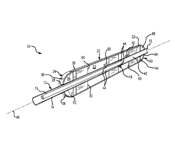
Figure 1 is a perspective cross-sectional view of one embodiment of a borehole
mapping
tool according to the teachings provided herein;
Figure 2 is a cross-sectional in elevation of the borehole mapping tool
illustrated in Figure
1;
Figure 3 is a schematic side view in elevation of a borehole with the borehole
mapping tool
provided therein;
Figure 4 is a side view in elevation of a borehole mapping tool string
comprising 3
individual borehole mapping tools; and
Figure 5 is a schematic side view in elevation of a borehole having the
borehole mapping
tool string illustrated in Figure 4 provided therein.
CA 03087197 2020-06-26
WO 2020/081057
PCT/US2018/056025
-3-
Best Mode for Carrying Out the Invention
One embodiment of a borehole mapping tool 10 is best seen in Figures 1 and 2
and may
comprise a probe housing or casing 12 having first and second ends 14 and 16.
Probe casing 12 is
sized to receive one or more location probes 18. The location probe(s) 18 are
operable, either alone
or in conjunction with other equipment and devices (not shown), to determine
the location of the
probe(s) 18 with respect to any convenient coordinate or location system.
Borehole mapping tool
may also comprise an outer housing or casing 20. The outer casing 20 may be
mounted to the
probe casing 12 so that an interior space or cavity 22 is defined between
outer casing 20 and probe
casing 12. As will be described in greater detail below, outer casing 20 may
be sized to be closely
10 received by the borehole 36 to be mapped, as best seen in Figure 3.
Borehole mapping tool 10 may also comprise a first end cap 24 mounted to a
first end 26
of outer casing 20. First end cap 24 may be provided with an opening 28
therein that is sized to
receive the probe casing 12. The arrangement is such that the first end 14 of
probe casing 12
extends beyond the first end cap 24. Similarly, borehole mapping tool 10 may
also comprise a
second end cap 30 mounted to a second end 32 of outer casing 20. Second end
cap 30 may be
provided with an opening 34 therein that is sized to receive the probe casing
12, again so that the
second end 16 of probe casing 12 extends beyond the second end cap 30.
In some embodiments, borehole mapping tool 10 maybe provided with one or more
nozzles
38 that are fluidically connected to a supply of drilling fluid 40 (Figure 3).
Nozzles 38 may be
mounted to the first and second end caps 24 and 30, although other
arrangements are possible.
Drilling fluid 40 discharged from the nozzles 40 helps to lubricate the
borehole mapping tool 10
as it moves within borehole 36, thereby reducing the forces required to move
the borehole mapping
tool 10 through borehole 36. Drilling fluid 40 may also assist in the
dislodgement and removal of
any loose or partially-excavated material that may remain in borehole 36. In
one embodiment, the
drilling fluid 40 may pumped through an interior conduit 42 defined by probe
casing 12. The
various nozzles 38 may be fluidically connected to the interior conduit 42 so
that pressurized
drilling fluid 40 contained therein is conducted to nozzles 38.
With reference now primarily to Figure 3, the borehole mapping tool 10 may be
used as
follows to map the location of the borehole 36. Assuming that the borehole 36
is ready to receive
the pipeline, i.e., that the pilot and reaming phases have been completed, the
borehole mapping tool
10 may be positioned within a first end 45 of borehole 36. Thereafter,
borehole mapping tool 10
may be attached to a drill string 48. At this point, the location probe(s) 18
provided within the
borehole mapping tool 10 may be activated or otherwise energized so that they
can determine the
CA 03087197 2020-06-26
WO 2020/081057
PCT/US2018/056025
-4-
position of the borehole mapping tool 10 with respect to a suitable coordinate
or location system.
The borehole mapping tool 10 may then be moved through the borehole 36, e.g.,
by pushing or
pulling on the drill string 48, while collecting and/or recording data from
the location probe(s) 18.
In embodiments wherein the location probe(s) 18 include magnetometers, the
borehole mapping
tool 10 may be stopped periodically to take magnetic locating shots. Such
magnetic locating shots
may be used as a second verification of the actual location of the borehole 36
within the formation.
The collected sensor data along with the secondary magnetic locating shots may
then be used to
produce a map of the borehole 36.
If desired, one or more reamers (not shown) may be mounted to either or both
of the first
and second ends 14 and 16 of borehole mapping tool 10. The use of such reamers
may reduce the
risk of borehole collapse or otherwise reduce the likelihood that the borehole
mapping tool 10 will
become stuck or jammed within borehole 36. In some applications, it may be
advantageous to
connect together multiple borehole mapping tools 10, 10', and 10" to create
borehole mapping tool
string 72, as best seen in Figures 4 and 5. The borehole mapping tool string
72 may then be pushed
or pulled through the borehole 36 in the manner described herein in order to
map the location of the
borehole 36.
A significant advantage of the present invention is that it may be used to map
the location
of a completed borehole 36 to determine whether it accurately follows the
planned or desired
pathway. Significant deviations from the desired pathway may be detected and
evaluated in
advance of pipeline installation. If necessary or desirable, remedial measures
may be taken to
correct any significant deviations before the pipeline is installed. Besides
ensuring that the installed
pipeline will be located within an acceptable tolerance of the defined
pathway, any deviations that
would result in excessive deformations of the pipeline (e.g., resulting from a
radius of curvature that
is too small for the planned pipeline) also can be corrected, thereby
significantly reducing the
likelihood of subsequent in-service failures.
Still other advantages associated with the present invention include the
ability to accurately
map the centerline of the borehole 36. Such accurate mapping is the result of
sizing the outer casing
20 so that it is closely received by the borehole 36. Because the location
probe(s) 18 are located
substantially along the centerline 46 of the borehole mapping tool 10, the
resulting position data will
correspond with the centerline of the borehole 36. No additional coordinate
transformations or
adjustments will be required.
Still other advantages are associated with the nozzles 38 that may be provided
on the
borehole mapping tool 10. The provision of drilling fluid 40 to the nozzles 38
during the mapping
CA 03087197 2020-06-26
WO 2020/081057
PCT/US2018/056025
-5-
operation will help to reduce the forces required to move the borehole mapping
tool 10 through the
borehole 36. The drilling fluid 40 may also help to remove any remaining loose
or partially-
excavated material that may remain in the borehole 36. If one or more reamers
(not shown) are
mounted to the borehole mapping tool 10, the provision of drilling fluid 40
will also enhance the
operation of the reamers, e.g., by providing lubrication, cooling, and removal
of reamed material.
If multiple borehole mapping tools 10, 10', and 10" are connected together to
form a string 72, the
resulting borehole map will generally be of increased accuracy. In addition,
the use of a string 72
of multiple borehole mapping tools 10, 10', and 10" will speed the mapping
process in that fewer
stops will be required to perform the magnetic survey shots. Of course, the
use of multiple borehole
mapping tools 10 also will provide system redundancy in the event one or more
of the locating
probes 18 fails or otherwise becomes inoperative during the mapping operation.
Having briefly described certain exemplary embodiments of systems and methods
of the
present invention, as well as some of its more significant features and
advantages, various
embodiments and variations of the present invention will now be described in
detail. However,
before proceeding the description, it should be noted that while various
embodiments are shown and
described herein as they could be used in a horizontal directional drilling
operation to map the
location of a reamed borehole in advance of pipeline installation, the present
invention is not limited
to use in such applications. For example, the methods and systems of the
present invention could
be used in any of a wide range of applications wherein it would be desirable
to obtain a highly
accurate map of an underground borehole. Consequently, the present invention
should not be
regarded as limited to use in any particular type of directional drilling
operation, environment, or
application.
Referring back now to Figures 1 and 2, one embodiment of the borehole mapping
tool 10
may comprise an elongate, generally cylindrically-shaped structure defined
primarily by probe
casing 12, outer casing 20, and first and second end caps 24 and 30. As will
be described in further
detail below, it is generally preferred, but not required, to configure the
borehole mapping tool 10
so that it may be readily used with existing directional drilling equipment,
such as drilling rigs, drill
strings, and drilling fluid delivery systems.
In the particular embodiments shown and described herein, probe casing 12 may
comprise
a generally elongate, cylindrically-shaped member having a first end 14 and a
second end 16. Probe
casing 12 is hollow and defines an interior conduit 42 of sufficient size to
receive one or more
location probes 18. The location probes 18 may be mounted within the interior
conduit 42 of probe
casing 12 by means of one or more probe stabilizer members 44 so that the
location probes 18 are
CA 03087197 2020-06-26
WO 2020/081057
PCT/US2018/056025
-6-
located substantially along a central axis 46 of probe casing 12. In most
embodiments, the interior
conduit 42 of probe casing 12 will be fluidically connected to a supply of
drilling fluid 40 via drill
string 48. See Figure 3.
In embodiments wherein the borehole mapping tool is configured to interface
with a
conventional drill string 48, probe casing 12 may be configured so that the
first and second ends 14
and 16 thereof can be readily connected to drill string 28, e.g., by means of
threaded connections.
So configuring the probe casing 12 will also allow the borehole mapping tool
10 to be operatively
connected to one or more reamers (not shown), which may be desirable in
certain applications. In
some embodiments, first end 14 of probe casing 12 may be provided with an
orientation stub 76 to
allow the borehole mapping tool to be connected to drill string 48.
The overall dimensions (e.g., diameter and overall length) of the probe casing
12 may
comprise any of a wide range of values depending on the particular application
and type of drilling
equipment to be used. Consequently, the present invention should not be
regarded as limited to
probe casings 12 having any particular size. However, by way of example, in
one embodiment,
probe casing 12 may have an outside diameter 50 of about 17 cm (about 6.75
inches) and inside
diameter 52 of about 10.2 cm (about 4 inches). Probe casing 12 may have an
overall length 54 of
about 8.5 m (about 28 feet).
Probe casing 12 may be fabricated from any of a wide range of materials, such
as various
metals and metal alloys, that are now known in the art or that may be
developed in the future that
are, or would be, suitable for the particular application. Consequently, the
present invention should
not be regarded as limited to any particular material. In embodiments wherein
one or more of the
location probes 18 utilize magnetometers, probe casing 12 should be fabricated
from a non-
magnetic material, such as non-magnetic stainless steel or MonelCD. Monel is a
registered
trademark of the Huntington Alloys Corporation, Huntington, WV (US) for metal
alloys containing
nickel and copper.
As mentioned, location probes 18 may be mounted within the interior cavity 42
defined by
probe casing 12 so that the location probes 18 are located substantially along
the central axis 46 of
probe casing 12. By way of example, in one embodiment the location probes 18
may be mounted
to probe casing 12 via a plurality of stabilizer members or 'spiders' 44, as
best seen in Figure 1.
Location probe(s) 18 may also be mounted to a probe extender 74 to allow the
location probe(s) 18
to be readily positioned at about the midpoint of probe casing 12.
Location probes 18 may comprise any of a wide range of downhole location
probes or
measurement-while-drilling (MWD) probes that are now known in the art or that
may be developed
CA 03087197 2020-06-26
WO 2020/081057
PCT/US2018/056025
-7-
in the future that are, or would be suitable, for mapping the location of the
probe(s) 18, and by
extension borehole mapping tool 10, as it moves within borehole 36. Location
probe(s) 18 of the
type suitable for use with the present invention typically involve a
combination of accelerometers
and magnetometers to provide the location functionality. Alternatively, other
devices are known
and may be used as well. However, because such location probes are well-known
in the art and
could be readily provided by persons having ordinary skill in the art after
having become familiar
with the teachings of the present invention, the particular location probe(s)
18, as well as any
ancillary systems and devices that my be required for their operation, will
not be described in further
detail herein.
With reference now primarily to Figure 2, borehole mapping tool 10 may also
comprise an
outer casing 20. In one embodiment, outer casing 20 may comprise an elongate,
generally
cylindrically-shaped member having a first end 26 and a second end 32. The
outside diameter 56
of outer casing 20 is selected so that outer casing 20 will be closely
received by the final, reamed
borehole 36. See Figure 3. Outer casing 20 may have an overall length 58 that
is less than the
overall length 54 of probe casing 12. This will allow the first and second
ends 14 and 16 of probe
casing 12 to extend beyond the outer casing 20, as best seen in Figure 2. By
way of example, in one
embodiment, the outer casing 20 may have an outside diameter 56 of about 61 cm
(about 24 inches)
and an overall length 58, of about 5.5 m (about 18 feet).
Before proceeding with the description, it should be noted that, as used
herein, the term
'closely received' should be understood to encompass a range of clearances
between the outside
diameter 56 of outer casing 20 and the diameter of the reamed borehole 36. The
clearance should
be sufficiently large so as to allow the borehole mapping tool 10 to move
within the borehole 36
without a substantial likelihood that it will become stuck or jammed within
the borehole 36. On
the other hand, the clearance should not be so large as to permit the borehole
mapping tool 10 to
move within the borehole 36 by an amount that would exceed the allowable
positional tolerance for
a particular application. Moreover, and because the present invention could be
used to map
boreholes 36 having diameters ranging from a few centimeters to a few meters,
and because the
boreholes 36 could extend though a wide range of formations having a wide
range of characteristics,
from hard, rocky formations to soft, sandy formations, the present invention
should not be regarded
as limited to any particular clearance between the borehole 36 and the
borehole mapping tool 10,
expressed either as an absolute measurement or as a percentage or ratio
between the diameters of
the outer casing 20 and borehole 36.
Outer casing 20 may be fabricated from any of a wide range of materials, such
as metals and
CA 03087197 2020-06-26
WO 2020/081057
PCT/US2018/056025
-8-
metal alloys, that are now known in the art or that may be developed in the
future that are, or would
be, suitable for the particular application. In embodiments wherein one or
more of the location
probes 18 utilize magnetometers, then outer casing 20 should be fabricated
from a non-magnetic
material, such as non-magnetic stainless steel or Mone10.
Outer casing 20 may be mounted to or secured to probe casing 12 by a plurality
of stabilizers
or 'spiders' 60 extending between probe casing 12 and outer casing 20. See
Figures 1 and 2. In the
particular embodiments shown and described herein, each stabilizer 60
comprises a flat, generally
plate-shaped member sized to extend between the two casing members 12 and 20.
The stabilizers
60 may be attached to the two casing members 12 and 20 by any convenient
means, such as by
welding. In the particular embodiment illustrated in Figures 1 and 2, four (4)
stabilizers or spiders
60 are mounted around probe casing 12 at 900 angles to one another. However,
other embodiments
may utilize a greater or lesser number of stabilizers 60. For example, another
embodiment may use
three (3) stabilizers 60 mounted around probe casing 12 spaced about 120
apart.
The various stabilizers 60 may be fabricated from any of a wide range of
materials, such as
metals and metal alloys, that are now known in the art or that may be
developed in the future that
are, or would be, suitable for the particular application. Here again, in
embodiments wherein one
or more of the location probes 18 utilize magnetometers, the various
stabilizers 60 should be
fabricated from non-magnetic materials, such as non-magnetic stainless steel
or MonelCD.
Borehole mapping tool 10 may also be provided with first and second end caps
24 and 30.
End caps 24 and 30 close off the interior space 22 defined between the probe
casing 12 and outer
casing 20. End caps 24 and 30 also allow the borehole mapping tool 10 to more
easily move
through the borehole 36 during the mapping operation. With reference now
primarily to Figures
1 and 2, first end cap 24 may be mounted to the first end 26 of outer casing
20. First end cap 24
may be provided with an opening 28 therein that is sized to receive probe
casing 12. This will allow
the first end 14 of probe casing 12 to extend beyond the first end cap 24.
Second end cap 30 may
be mounted to the second end 32 of outer casing 20. Second end cap 30 also may
be provided with
an opening 34 therein that is sized to receive the probe casing 12 so that the
second end 16 of probe
casing 12 extends beyond the second end cap 30.
First and second end caps 24 and 30 may comprise any of a wide range of
shapes, such as
conical, ellipsoidal, or hemispherical, to allow the borehole mapping tool to
more easily move
through borehole 36. By way of example, in one embodiment, the first and
second end caps 24 and
30 are substantially hemispherical in shape.
First and second end caps 24 and 30 may be fabricated from any of a wide range
of
CA 03087197 2020-06-26
WO 2020/081057
PCT/US2018/056025
-9-
materials, such as metals and metal alloys, that are now known in the art or
that may be developed
in the future that are, or would be, suitable for the particular application.
In embodiments wherein
one or more of the location probes 18 utilize magnetometers, then first and
second end caps 24 and
30 should be fabricated from non-magnetic materials, such as non-magnetic
stainless steel or
Mone10.
In many embodiments, the borehole mapping tool 10 may also be provided with
one or more
nozzles 38 that are fluidically connected to the supply of drilling fluid 40.
In the particular
embodiments shown and described herein, four (4) individual nozzles 38 are
mounted to each of
the first and second end caps 24 and 30, as best seen in Figures 1 and 2.
Alternatively, the nozzles
could be provided elsewhere on borehole mapping tool 10. As mentioned earlier,
the various
nozzles 38 are fluidically connected to the supply of drilling fluid 40
(Figure 3). In embodiments
wherein the drilling fluid 40 is supplied to the interior conduit 42 of probe
casing 12, the various
nozzles 38 may be fluidically connected to the interior conduit 42 of probe
casing 12 via the first
and second end caps 24 and 30. In such an embodiment, respective first and
second isolation
bulkheads 62 and 64 may be used to define respective first and second drilling
fluid chambers 66
and 68 that are sealed or isolated from the interior space 22. Suitable
openings 70 provided in the
probe casing 12 to allow drilling fluid 40 in the interior conduit 42 to pass
into the first and second
drilling fluid chambers 66 and 68. Thereafter, the drilling fluid, which is
under pressure, will be
ejected from nozzles 38.
Nozzles 38 may comprise any of a wide range of drilling fluid nozzles that are
readily
commercially available and could be easily provided by persons having ordinary
skill in the art after
having become familiar with the teachings provided herein. Consequently, the
nozzles 38 that may
be used in one embodiment will not be described in further detail herein.
Referring now primarily to Figure 3, the borehole mapping tool 10 may be used
as follows
to map the location of an underground borehole 36. Once the borehole 36 is
ready to receive the
pipeline, i.e., once the pilot and reaming phases have been completed, the
borehole mapping tool
10 may be positioned within first end 45 of borehole 36 and attached to a
drill string 48. The
location probe(s) 18 provided within the borehole mapping tool 10 may then be
energized or
otherwise activated so that they can determine the position of the borehole
mapping tool 10 with
respect to the desired coordinate system. The borehole mapping tool 10 may
then be moved
through the borehole 36, e.g., by pushing the drill string 48 in the direction
of arrow 78, while
collecting and/or recording data from the location probe(s) 18. In this regard
it should be noted that
the borehole mapping tool 10 may be either pushed or pulled through borehole
36. In embodiments
CA 03087197 2020-06-26
WO 2020/081057
PCT/US2018/056025
-10-
provided with drilling fluid nozzles 38, drilling fluid 40 may be pumped
through drill string 48 and
thence nozzles 38 to assist in the movement of tool 10 through borehole 36. In
embodiments
wherein the location probes include magnetometers, the borehole mapping tool
10 may be stopped
periodically to take magnetic locating shots. Such magnetic locating shots may
be used as a second
verification of the actual location of the borehole 36. The collected sensor
data along with the
secondary magnetic locating shots may then be used to produce a map of the
borehole 36 within the
formation.
If desired, one or more reamers (not shown) may be mounted to either or both
of the first
and second ends 14 and 16 of borehole mapping tool 10. Drilling fluid 40 may
be pumped through
drill string 48 and nozzles 38 to assist the reamers. The use of such reamers
may reduce the risk
of borehole collapse or otherwise reduce the likelihood that the borehole
mapping tool 10 will
become stuck or jammed within borehole 36.
In some applications, it may be advantageous to connect multiple borehole
mapping tools
10, 10', and 10" together to create borehole mapping tool string 72, as best
seen in Figures 4 and 5.
The tool string 72 may then be pushed or pulled through the borehole 36, e.g.,
in the direction
indicated by arrow 78, in the manner described herein in order to map the
location of the borehole
36. Drilling fluid 40 may be pumped through drill string 48 to assist in the
movement of the tool
string 72 through borehole 36. If desired, one or more reamers (not shown) may
also be attached
to tool string 72 to further assist the movement of the tool string 72 through
borehole 36 during the
mapping operation.
Having herein set forth preferred embodiments of the present invention, it is
anticipated that
suitable modifications can be made thereto which will nonetheless remain
within the scope of the
invention. The invention shall therefore only be construed in accordance with
the following claims: