Note: Descriptions are shown in the official language in which they were submitted.
-1- 19-
0515CA01
Description
SYSTEM AND METHOD FOR AVOIDING CONTACT BETWEEN
AUTONOMOUS AND MANNED VEHICLES CAUSED BY LOSS OF
TRACTION
Technical Field
The present disclosure relates generally to avoiding potential
collisions between autonomous and manned vehicles and, more particularly, to a
system and method for avoiding contact between autonomous and manned
vehicles caused by loss of traction.
Background
Machines such as, for example, on and off-highway haul trucks,
and other types of heavy equipment and vehicles are used to perform a variety
of
tasks. The various types of machines operating at any one time at a particular
job
site may include manned machines, semi-autonomous machines, and fully
autonomous machines. These different types of machines are often operating
along paths of travel that may run adjacent each other or in close proximity
to
each other, for example, as hauling machines such as dump trucks and loading
machines such as front end loaders travel near each other on their way to and
from digging, loading, and processing sites (such as rock crushers) for the
performance of various tasks at a job site. This traveling can include
traversing
one of many possible paths at a job site. The paths traversed by the machines
may include unpredictable surface conditions caused by weather conditions,
usage patterns, machine load losses, natural disasters, tectonic shifts, mud
slides,
rock slides, and/or other deteriorative events and/or processes. Roadways that
are
rendered unpredictable may have unpredictable portions, which may include, for
example, ice, mud, sand, loose gravel, standing water, or other combinations
of
surface characteristics leading to soft underfoot conditions. Off-highway
Date Recue/Date received 2020-09-17
-2- 19-
0515CA01
machines operating at job sites, such as oil sands mining sites in particular,
are
often subject to soft underfoot conditions, including surfaces that are loose
and
viscous, forcing trucks and other machines to modify driving behavior on the
fly.
The ability to make timely modifications to operating characteristics and
driving
behavior for the off-highway machines operating under these conditions is
largely dependent on predicting and identifying the presence of various types
of
roadway conditions such as soft underfoot conditions and potential slippage or
other behavior of the different types of machines operating in the vicinity of
each
other. Unpredictable portions of a job site may increase time and/or costs
associated with traveling between two or more locations, as well as increasing
the
risk of the trajectories of two machines crossing, resulting in potential
collisions.
A machine may traverse a portion of a job site, find that the surfaces in that
portion include standing water or other conditions resulting in especially
viscous
or soft conditions, and be re-routed along another one of the possible paths.
Moreover, as multiple machines traverse the same paths at a job site, soft
underfoot conditions may worsen as ruts formed by each machine are repeatedly
traversed by other machines. Re-routing machines at a job site may increase
time
and/or costs associated with traveling between two or more locations. The
unpredictable portions with soft underfoot conditions may also disable the
machine. For example, the machine may slip, get stuck, deplete its energy
(e.g.,
fuel or electric charge), crash, or otherwise be disabled by the unpredictable
portions.
One way to minimize the effect of unpredictable portions of
roadways is to facilitate communications between machines and/or remote
offices
regarding the unpredictable portions. An example of facilitating
communications
between machines and/or remote offices is described in U.S. Patent Application
Publication No. 2004/0122580 (the '580 publication) by Sorrells, published on
June 24, 2004. The '580 publication describes a control module, which
determines if a machine is operating on a road having an adverse road
condition.
Date Recue/Date received 2020-09-17
-3- 19-
0515CA01
Adverse road conditions include soft underfoot conditions, steep grades, and
potholes. Additionally, the '580 publication describes updating a site map
stored
in the control module or a remote office to show the adverse road condition.
The
'580 publication also describes using the control module or the remote office
to
notify an operator of the machine that the machine is approaching the adverse
road condition. Additionally, the '580 publication describes using the control
module or the remote office to dispatch a machine to the location of the
adverse
road condition for the purpose of correcting the adverse road condition.
However, the '580 publication does not provide a solution for
actually predicting the trajectory of a machine such as an autonomously or
semi-
autonomously operated machine as a result of loss of traction, with the
trajectory
resulting in a potential collision with another machine traveling on a nearby
path.
Moreover, the '580 publication does not provide a system and method for
controlling the autonomously or semi-autonomously operated machine to
maximize speed and productivity of the autonomous machine while minimizing
the risk of collision with another vehicle, and particularly with a manned
vehicle
traveling along an adjacent path while completing of its designated tasks.
The present disclosure is directed to overcoming one or more of
the problems set forth above and/or other problems in the art.
Summary
In one aspect, the present disclosure is directed to a control system
for preventing vehicle collisions. The control system may include a vehicle
location information determination module, a terrain determination module, a
terrain surface coefficient of friction estimation module, and a sensing
system
configured to generate signals indicative of data representing one or more of
vehicle speed, vehicle pose, vehicle size, vehicle weight, vehicle tire type,
vehicle
load, vehicle gear ratio, weather characteristics, and road conditions for a
vehicle
operating at a job site. A manned vehicle trajectory determination module may
be configured to receive location information from the vehicle location
Date Recue/Date received 2020-09-17
-4- 19-
0515CA01
information determination module and plot a first travel path for a manned
vehicle based at least in part on a location, heading, and speed of the manned
vehicle and a desired destination for the manned vehicle. An autonomous
vehicle
trajectory determination module may be configured to receive location
information from the vehicle location information determination module,
terrain
information from the terrain determination module, and terrain surface
coefficient
of friction information from the terrain surface coefficient of friction
estimation
module, plot a second travel path for an autonomous vehicle from a location of
the autonomous vehicle to a desired destination for the autonomous vehicle,
and
determine projected slide trajectories for the autonomous vehicle at
successive
positions along the second travel path where the autonomous vehicle is
predicted
to lose traction based at least in part on signals received from the sensing
system.
A comparison module may be configured to determine if any of the projected
slide trajectories for the autonomous vehicle conflict with simultaneous
positions
of the manned vehicle traveling along the first travel path. An autonomous
vehicle command control module may be configured to change an operating
characteristic of the autonomous vehicle if the comparison module identifies
any
potential contact between the autonomous vehicle and the manned vehicle.
In another aspect, the present disclosure is directed to a method for
preventing vehicle collisions. The method may include determining a vehicle
location, using a vehicle location information determination module,
determining
a terrain on which the vehicle is operating, using a terrain determination
module,
estimating a terrain surface coefficient of friction, using a terrain surface
coefficient of friction estimation module, and generating signals indicative
of
data representing one or more of vehicle speed, vehicle pose, vehicle size,
vehicle
weight, vehicle tire type, vehicle load, vehicle gear ratio, weather
characteristics,
and road conditions for a vehicle operating at a job site, using a sensing
system.
The method may also include receiving location information of a manned vehicle
from the vehicle location information determination module and plotting a
first
Date Recue/Date received 2020-09-17
-5- 19-
0515CA01
travel path for the manned vehicle based at least in part on a location,
heading,
and speed of the manned vehicle and a desired destination for the manned
vehicle, using a manned vehicle trajectory determination module, receiving
location information of an autonomous vehicle from the vehicle location
information determination module, terrain information from the terrain
determination module, and terrain surface coefficient of friction information
from
the terrain surface coefficient of friction estimation module, plotting a
second
travel path for the autonomous vehicle from a location of the autonomous
vehicle
to a desired destination for the autonomous vehicle, and determining projected
slide trajectories for the autonomous vehicle at successive positions along
the
second travel path where the autonomous vehicle is predicted to lose traction
based at least in part on signals received from the sensing system, using an
autonomous vehicle trajectory determination module. The method may still
further include determining if any of the projected slide trajectories for the
autonomous vehicle conflict with simultaneous positions of the manned vehicle
traveling along the first travel path, using a comparison module, and changing
an
operating characteristic of the autonomous vehicle if the comparison module
identifies any potential contact between the autonomous vehicle and the manned
vehicle, using an autonomous vehicle command control module.
In another aspect, the present disclosure is directed to a computer-
readable medium for use in preventing collisions between an autonomous vehicle
and a manned vehicle traveling along adjacent, curved travel paths at a job
site,
the computer-readable medium including computer-executable instructions for
performing a method that may include determining locations of the autonomous
vehicle and the manned vehicle, using a vehicle location information
determination module, determining a terrain on which the autonomous vehicle is
operating, using a terrain determination module, estimating a terrain surface
coefficient of friction for the autonomous vehicle, using a terrain surface
coefficient of friction estimation module, and generating signals using a
sensing
Date Recue/Date received 2020-09-17
-6- 19-
0515CA01
system, the signals being indicative of data representing one or more of
autonomous vehicle physical and operating characteristics including speed,
pose,
size, weight, tire type, load, gear ratio, weather characteristics, and road
conditions for the travel path along which the autonomous vehicle is
operating.
The method may also include receiving location information for the manned
vehicle from the vehicle location determination module and plotting a first
travel
path for the manned vehicle based at least in part on the location, heading,
and
speed of the manned vehicle and a desired destination for the manned vehicle,
using a manned vehicle trajectory determination module, receiving location
information for the autonomous vehicle from the vehicle location determination
module, terrain information from the terrain determination module, and terrain
surface coefficient of friction information from the terrain surface
coefficient of
friction estimation module, plotting a second travel path for the autonomous
vehicle from a location of the autonomous vehicle to a desired destination for
the
autonomous vehicle, and determining projected slide trajectories for the
autonomous vehicle at successive positions along the second travel path where
the autonomous vehicle is predicted to lose traction based at least in part on
signals received from the sensing system, using an autonomous vehicle
trajectory
determination module. The method may still further include determining if any
of the projected slide trajectories for the autonomous vehicle conflict with
simultaneous positions of the manned vehicle traveling along the first travel
path,
using a comparison module, and changing an operating characteristic of the
autonomous vehicle if the comparison module identifies any potential contact
between the autonomous vehicle and the manned vehicle, using an autonomous
vehicle command control module.
Brief Description of the Drawings
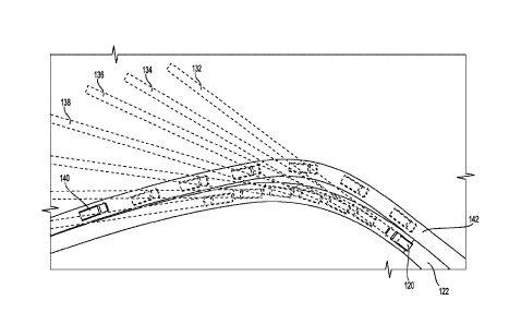
Fig. 1 is a schematic illustration of exemplary vehicles operating
at a job site, with projected slip trajectories for an autonomous vehicle
crossing a
path of a manned vehicle; and
Date Recue/Date received 2020-09-17
-7- 19-
0515CA01
Fig. 2 is a block diagram of an exemplary system according to an
embodiment of this disclosure.
Detailed Description
Fig. 1 illustrates an exemplary implementation of a system and
method according to this disclosure with a first autonomous vehicle 120
traveling
along a first curved path 122 in a first direction, as shown from the right
hand
side of Fig. 1 toward the left hand side. An exemplary manned vehicle 140 is
also traveling along a second curved path 142 extending adjacent to first path
122, with manned vehicle 140 traveling in a second direction essentially
opposite
to the first direction, as shown from the left hand side of Fig. 1 toward the
right
hand side. The two exemplary, curved and adjacent paths 122, 142 may be
located at a job site, such as an oil sands location, or other mining location
or
work site. Autonomous vehicle 120 and manned vehicle 140 may be, for
example, an off-highway truck, a mining shovel, a wheel loader, a track
loader, a
backhoe, a hydraulic excavator, or any other type of machine known in the art.
Each vehicle 120, 140 may include a chassis supported by a pair of front
wheels
and a pair of rear wheels. At least the front wheels may be steerable, and the
chassis may include front and rear frame portions that may be capable of
relative
articulation. In various alternative implementations, each of vehicles 120,
140
may include an on-board operator station, which may provide accommodations
for an operator and also may house control equipment that enables each vehicle
to be operated manually, remotely, semi-autonomously, or fully autonomously.
As shown in the exemplary implementation of Fig. 1, manned
vehicle 140 may travel along known path 142, based on one or more of an
operator's knowledge of a desired path from one point at a work site to
another
point, physical markings along the desired path, instructions received in an
operator's cabin of vehicle 140 via wired or wireless communications of
current
geographical positions and directional headings to follow along the desired
path,
a display such as a virtual reality display or augmented reality display in
the
Date Recue/Date received 2020-09-17
-8- 19-
0515CA01
operator's cabin showing a representation of the manned vehicle traveling
along
the desired path in real time, etc. Manned vehicle 140 may perform some type
of
operation associated with an industry such as mining, construction, farming,
freighting, or another industry. Although manned vehicle 140 may be designed
to operate with a human operator, alternative implementations may include
autonomous or semi-autonomous vehicles designed to operate without an
operator. In any case, each of the machines may be, for example, an on or off-
highway haul truck, or another type of equipment, which may haul a load
material. Vehicle 120, 140 may be a motor grader, an excavator, a dozer, a
water
truck, or another type of equipment, which may repair paths 122, 142.
A worksite including paths 122, 142 may be, for example, a mine
site, a landfill, a quarry, a construction site, a logging site, a road
worksite, or any
other type of worksite. In an exemplary implementation, vehicles 120, 140 may
travel between locations at an oil sands mining site, and may encounter soft
underfoot conditions often experienced at oil sands mining sites. The roadways
at an oil sands mining site may at times be rendered unpredictable by for
example, weather conditions, usage patterns, machine load losses, natural
disasters, tectonic shifts, mud slides, rock slides, and/or other
deteriorative events
and/or processes. These roadways may include unpredictable portions, which
may increase time and/or costs associated with traveling between locations.
Additionally, the unpredictable portions may disable vehicles by, for example,
causing vehicles to slip, get stuck, deplete their energy (e.g., fuel or
electric
charge), or crash. Some of the unpredictable portions of paths 122, 142 at an
oil
sands location may include soft underfoot condition portions, iced portions,
wet
portions, or portions with oil or other slippery materials, which may cause
vehicles to experience significant wheel slip and/or rolling resistance, or to
lose
traction with the ground surface. Each location along paths 122, 142 with
conditions that affect traction of one of vehicles 120, 140 may or may not
affect a
heading and/or location of the vehicle. For example, a soft underfoot
condition
Date Recue/Date received 2020-09-17
-9- 19-
0515CA01
may cause the vehicle to fishtail, irregularly accelerate (accelerate slower
than
expected), or irregularly decelerate (decelerate slower than expected).
Alternatively or additionally, the soft underfoot or other road surface
condition
may cause one or more traction devices of the vehicle to rotate irregularly
(faster
or slower than expected), or result in the vehicle experiencing unacceptable
or
undesirable changes in pitch rate, yaw rate, and/or roll rate.
Soft underfoot conditions or other road surface conditions
conducive to slippage of a work vehicle may be identified by an operator of a
particular machine such as manned vehicle 140, or by sensors associated with
autonomous vehicle 120. With manned vehicle 140, identification of surface
conditions that may affect the trajectory of manned vehicle 140 may be based
on
the operator's experiences when operating the same or similar machines due to
various sensory inputs to the operator such as force feedback (generally
referred
to as haptic feedback) through various controls and/or an operator seat,
visual
feedback, auditory feedback, and proprioceptive feedback. Alternatively or in
addition, surface conditions such as soft underfoot conditions may be
identified
without any operator input, such as by comparisons of values for various
signals
received from sensors to predetermined threshold values. Each vehicle 120, 140
may include a loss of traction response system configured to predict,
identify,
avoid, and/or minimize the effects of underfoot condition portions of a travel
path
that may affect the trajectory of the vehicle by changing ways in which the
machine operates. An exemplary purpose of a system according to various
embodiments of this disclosure may be to maximize the speed and productivity
of
autonomous vehicle 120 while minimizing any risk of collision with manned
vehicle 140.
In the exemplary implementation illustrated in Fig. 1, manned
vehicle 140 is assumed to be controlled by an operator to follow predetermined
path 142 in a known manner, and autonomous vehicle 120 is made aware of the
path 142 being traveled by manned vehicle 140, as well as the projected
positions
Date Recue/Date received 2020-09-17
-10- 19-
0515CA01
of manned vehicle 140 along path 142 at each of predetermined time intervals.
The communication of real time data indicative of the location, speed, and
heading of manned vehicle 140 to autonomous vehicle 142 may be similarly
implemented for additional manned or autonomous vehicles operating in the
vicinity of operation of autonomous vehicle 120. The planned location, speed,
and trajectory of autonomous vehicle 120 at each of successive points in time
as
autonomous vehicle 120 travels along path 122 may also be programmed into an
autonomous vehicle command control module 240.
As shown in Fig. 1, variable factors such as vehicle characteristics,
weather characteristics, and road surface conditions may affect terrain
surface
coefficient of friction values along path 122 for autonomous vehicle 120. As a
result, a speed of autonomous vehicle 120 and the radius of curvature of path
122
at each of a plurality of successive points along travel path 122 may result
in a
lateral acceleration of autonomous vehicle 120 equal to the square of
autonomous
vehicle speed (V2) divided by the radius of curvature (R). The lateral
acceleration of autonomous vehicle 120 as it travels along curved path 122 may
exceed a lateral acceleration at which autonomous vehicle 120 loses traction
with
the surface and slides along a slide trajectory 132, 134, 136, 138. Each slide
trajectory from a point at which autonomous vehicle 120 is predicted to lose
traction with a surface of path 122 is essentially tangent to the directional
heading
of autonomous vehicle 120 at the moment it loses traction. As shown in Fig. 1,
each of these projected slide trajectories may be approximated according to
implementations of this disclosure as an elongated "slip polygon," which has
an
approximate width based on dimensions of the vehicle, and an approximate
length corresponding to the distance autonomous vehicle 120 will slide based
on
factors that include vehicle speed, vehicle characteristics, weather
characteristics,
and road surface conditions.
Fig. 2 is an illustration of a system according to an exemplary
embodiment of this disclosure for utilizing real-time data for predictive
analysis
Date Recue/Date received 2020-09-17
-11- 19-
0515CA01
of potential interactions between autonomous vehicle 120 traveling along
curved
path 122 and manned vehicle 140 traveling along curved path 142 adjacent to
second curved path 142. The system may include a vehicle location information
determination module 212, which is configured to receive data from a series of
sensors such as Global Positioning System (GPS) receivers, Inertial Reference
Units (IRU), Inertial Measurement Units (IMU), Dead-Reckoning Navigation
units, RADAR, LIDAR, and the like. Additionally, the system may include a
terrain determination module 222 configured for determining characteristics of
the terrain over which the vehicles are traveling, such as pitch and grade.
Real
time data may also be provided by a terrain surface coefficient of friction
estimation module 224, which is configured to receive data from a sensing
system, wherein the data is representative of various vehicle characteristics,
weather characteristics, or road surface conditions that may contribute to
slip
conditions and affect the behavior of one or both of manned vehicle 140 and
autonomous vehicle 120 as the vehicles travel along paths 142, 122.
In one exemplary embodiment of this disclosure, the sensing
system associated with terrain surface coefficient of friction estimation
module
224 may be configured to generate signals indicative of characteristics of
autonomous vehicle 120 that may affect whether the vehicle slips at any
particular point in time or position as it travels along travel path 122.
These
autonomous vehicle characteristics may include, for example, vehicle speed,
vehicle pose, vehicle size, vehicle weight, the types and conditions of the
vehicle
tires, vehicle loads, and current gear ratios of a drive train for the
vehicle. The
sensing system may also be configured to generate signals indicative of
weather
characteristics at the time that may affect slippage of the vehicle, such as
ambient
temperature, humidity, rain, wind, ice, snow, etc. The sensing system may be
still further configured to generate signals indicative of road surface
conditions,
such as those discussed above, leading to soft underfoot conditions, and other
Date Recue/Date received 2020-09-17
-12- 19-
0515CA01
road surface conditions contributing to slippage of autonomous vehicle 120 as
it
travels along path 122.
Data on the geographic location of manned vehicle 140 may be
provided in real time to manned vehicle trajectory determination module 210
and
to autonomous vehicle trajectory determination module 220. In various
embodiments, vehicle location information determination module 212 may be
included as part of an off-board central processing system, or as part of an
on-
board processing system, with sensors such as one or more GPS receivers
mounted directly on one or both of manned vehicle 140 and autonomous vehicle
120. Manned vehicle trajectory determination module 210 may also be
configured to receive real time input that shows the position of manned
vehicle
140 on a map of a work site, including the position of manned vehicle 140
relative to other job site characteristics such as hazards, fixed obstacles,
and
updated changes to terrain, as provided by terrain determination module 222.
The system including manned vehicle trajectory determination
module 210 and autonomous vehicle trajectory determination module 220, as
illustrated in Fig. 2, may additionally or alternatively include any
combination of
processing modules configured to receive signals indicative of characteristics
and
conditions that may affect trajectories for both manned vehicle 140 and
autonomous vehicle 120. As shown in Fig. 2, the sensors may include location
sensors such as GPS, IMU, RADAR, LIDAR, and other sensors providing real
time data on the positions of manned vehicle 140 and autonomous vehicle 120.
Additional sensors may provide signals indicative of the pitch and grade of
the
terrain along which paths 122, 142 traverse, and signals indicative of
characteristics of the vehicles, weather characteristics, and road surface
conditions that may affect the potential slide trajectories 132, 134, 136, 138
of
autonomous vehicle 120 if autonomous vehicle 120 exceeds a lateral
acceleration
limit value (a), above which slippage of the vehicle is likely to occur.
Date Recue/Date received 2020-09-17
-13- 19-
0515CA01
In one exemplary embodiment, the various sensors may be
configured to output data in an analog format. In another embodiment, the
sensors may be configured to output data in a digital format. For example, the
same measurements of pitch, grade, vehicle characteristics, weather
characteristics, or road surface conditions may be taken in discrete time
increments that are not continuous in time or amplitude. In still another
embodiment, the sensors may be configured to output data in either an analog
or
digital format depending on the sampling requirements of manned vehicle
trajectory determination module 210 and autonomous vehicle trajectory
determination module 220.
The sensors can be configured to capture output data at split-
second intervals to effectuate "real time" data capture. For example, in one
embodiment, the sensors can be configured to generate thousands of data
readings per second. It should be appreciated, however, that the number of
data
output readings taken by a sensor may be set to any value as long as the
operational limits of the sensor and the data processing capabilities of the
various
modules are not exceeded.
As shown in Fig. 2, in one embodiment, a comparison module 230
may be configured for performing real time comparisons of projected slide
trajectories 132, 134, 136, 138 with simultaneous manned vehicle positions
along
predetermined travel path 142. The purpose of the comparisons performed by
comparison module 230 may be to determine potential conflicts between slide
trajectories of autonomous vehicle 120 and positions of manned vehicle 140 as
it
travels along path 142. In some alternative embodiments, comparison module
230 may receive information on projected real time positions of manned vehicle
140 and information on projected slide trajectories 132, 134, 136, 138 of
autonomous vehicle 120 for a wide range of potential conditions. One or more
of
the modules shown in Fig. 2 may include a virtual system modeling engine
configured to generate a large number of potential scenarios for the
trajectories of
Date Recue/Date received 2020-09-17
-14- 19-
0515CA01
manned vehicle 140 and autonomous vehicle 120 under a large number of
different conditions. The illustrated modules may also be associated with
calibration engines configured for checking the accuracy of virtual system
slide
trajectories of autonomous vehicle 120 versus actual slide trajectories
experienced during operation, and calibrating sensors and computations where
needed. The system may also include databases configured to store the large
amount of data associated with virtual and actual slip trajectories for
autonomous
vehicle 120. Additional engines or processing modules may also be included,
such as an operator behavior modeling engine associated with manned vehicle
140, a simulation engine associated with autonomous vehicle 120, and other
machine learning or artificial intelligence engines or processing modules. A
virtual system modeling engine included with one or more of the modules may be
used to precisely model and mirror the actual trajectories of manned vehicle
140
and autonomous vehicle 120, based on physics-based equations, historical data,
and/or empirical data derived from monitoring the behavior of similar vehicles
operating on the same or similar terrain under the same or similar conditions.
Analytics engines associated with each of the modules can be configured to
generate predicted data for the monitored systems and analyze differences
between the predicted data and the real-time data received from the various
sensors.
Real-time data on the trajectory of manned vehicle 140, as
generated by manned vehicle trajectory determination module 210, and on
projected slide trajectories of autonomous vehicle 120, as generated by
autonomous vehicle trajectory determination module 220 can be passed to a
comparison engine of comparison module 230 for performing real time
comparison of projected slide trajectories for autonomous vehicle 120 with
simultaneous manned vehicle positions along path 142 for manned vehicle 140.
In some implementations, the comparison engine may be configured to
continuously compare the real-time data with predicted values generated by a
Date Recue/Date received 2020-09-17
-15- 19-
0515CA01
virtual system modeling engine or another simulation engine included as part
of
one or more of the modules or as a separate module. Based on the comparison,
the comparison engine can be further configured to determine whether potential
conflicts between a projected slide trajectory of autonomous vehicle 120 and a
position of manned vehicle 140 are identified. Any identified potential
conflicts
can then be communicated to an autonomous vehicle command control module
240 configured for slowing autonomous vehicle 120 to remove the risk of a
collision between autonomous vehicle 120 and manned vehicle 140.
A control system for preventing vehicle collisions, according to
various embodiments of this disclosure, may include vehicle location
information
determination module 212, terrain determination module 222, and terrain
surface
coefficient of friction estimation module 224. Terrain surface coefficient of
friction estimation module 224 may include or be associated with a sensing
system configured to generate signals indicative of data representing one or
more
of vehicle speed, vehicle pose, vehicle size, vehicle weight, vehicle tire
type,
vehicle load, vehicle gear ratio, weather characteristics, and road conditions
for a
vehicle operating at a job site.
The control system may also include manned vehicle trajectory
determination module 210 configured to receive location information from
vehicle location information determination module 212 and plot a first travel
path
for manned vehicle 140, shown in Fig. 1, based at least in part on a location,
heading, and speed of the manned vehicle and a desired destination for the
manned vehicle. Autonomous vehicle trajectory determination module 220 may
also be configured to receive location information from vehicle location
information determination module 212. In addition, autonomous vehicle
trajectory determination module 220 may be configured to receive terrain
information from terrain determination module 222, and terrain surface
coefficient of friction information from terrain surface coefficient of
friction
estimation module 224, and plot second travel path 122 for autonomous vehicle
Date Recue/Date received 2020-09-17
-16- 19-
0515CA01
120 from a location of the autonomous vehicle to a desired destination for the
autonomous vehicle. Module 220 may also be configured to determine projected
slide trajectories 132, 134, 136, 138 for autonomous vehicle 120 at successive
positions along second travel path 122 where the autonomous vehicle is
predicted
to lose traction based at least in part on signals received from the sensing
system.
Comparison module 230 may be configured to determine if any of
the projected slide trajectories for autonomous vehicle 120 conflict with
simultaneous positions of manned vehicle 140 traveling along first travel path
142. Autonomous vehicle command control module 240 may be configured to
change an operating characteristic of autonomous vehicle 120 if the comparison
module identifies any potential contact between the autonomous vehicle and the
manned vehicle. In some exemplary embodiments, autonomous vehicle
command control module 240 may be configured to lower a speed of autonomous
vehicle 140 if the comparison module identifies any potential contact between
autonomous vehicle 120 and manned vehicle 140.
The control system according to various exemplary embodiments
of this disclosure may also include autonomous vehicle trajectory
determination
module 220 configured to receive data on one or more of a pitch and a grade of
second travel path 122 from terrain determination module 222 and data on a
terrain surface coefficient of friction of second travel path 122 from terrain
surface coefficient of friction estimation module 224. This data may be used
by
autonomous vehicle trajectory determination module 220 to determine a lateral
acceleration of autonomous vehicle 120 at each of predetermined intervals of
time corresponding to each of the successive positions of the autonomous
vehicle
along the second travel path based on a projected autonomous vehicle speed and
radius of curvature of the second travel path at each of the successive
positions
along the second travel path.
Date Recue/Date received 2020-09-17
-17- 19-
0515CA01
Autonomous vehicle trajectory determination module 220 may be
further configured to calculate a lateral acceleration limit value (a)
according to
the function:
a = V2/R,
wherein Vt is a target autonomous vehicle speed at or below which autonomous
vehicle 120 is predicted to maintain traction with the terrain surface and R
is the
radius of curvature of second travel path 122 at each of the successive
positions
of the autonomous vehicle traveling along the second travel path. Module 220
may be configured to determine whether the lateral acceleration of autonomous
vehicle 120 at each of the successive positions of the autonomous vehicle
along
the second travel path exceeds the lateral acceleration limit value (a) above
which
the autonomous vehicle is predicted to lose traction with the terrain surface.
Autonomous vehicle trajectory determination module 220 may be still further
configured to determine the curvature (C) of second travel path 120 at each of
the
successive positions along the second travel path to be equal to the
reciprocal of
the radius of curvature (R) of the second travel path at each of the
successive
positions of the autonomous vehicle traveling along the second travel path,
and
predict the target speed Vt according to the function:
Vt =
Terrain surface coefficient of friction estimation module 224 may
be configured to calculate the data on a terrain surface coefficient of
friction of
second travel path 120 using signals generated by the sensing system that are
indicative of terrain surface coefficient of friction input data representing
one or
more of pose of the autonomous vehicle, size of the autonomous vehicle, weight
of the autonomous vehicle, tire type on the autonomous vehicle, load carried
by
the autonomous vehicle, gear ratio of the autonomous vehicle, weather
characteristics, and road conditions for the second travel path encountered by
the
autonomous vehicle operating at the job site.
Date Recue/Date received 2020-09-17
-18- 19-
0515CA01
Various modules of the control system according to some
exemplary embodiments of this disclosure, such as terrain surface coefficient
of
friction estimation module 224, and autonomous vehicle trajectory
determination
module 220, may include a machine learning engine. The machine learning
engine may be configured to receive training data comprising historically or
empirically derived values for input data representing one or more of physical
or
operational characteristics of a second autonomous vehicle that are
approximately
the same as corresponding physical or operational characteristics of the
autonomous vehicle such as pose, size, weight, tire type, load, gear ratio,
weather
characteristics, and road conditions for the second autonomous vehicle
traveling
along at least one of the second travel path or a travel path with
approximately
the same pitch, grade, and other characteristics as the second travel path.
Physical or operational characteristics that are "approximately the same"
refers to
a selection of characteristics affecting the behavior of the second autonomous
vehicle that have been shown historically, empirically, and/or through the
implementation of physics-based equations to result in loss of traction and
slide
characteristics of an autonomous vehicle that fall within normally accepted
tolerances for avoiding risk of collision with another vehicle or object. The
training data may also include a plurality of historically or empirically
derived
slide trajectories of the second autonomous vehicle associated with the
historically or empirically derived input data.
The machine learning engine may be configured to train a learning
system using the training data to generate a plurality of projected slide
trajectories of the autonomous vehicle at each of the successive positions
along
the second travel path based on real time values for the input data using a
learning function including at least one learning parameter. Training of the
learning system may include providing the training data as an input to the
learning function, with the learning function being configured to use the at
least
one learning parameter to generate the plurality of projected slide
trajectories
Date Recue/Date received 2020-09-17
-19- 19-
0515CA01
based on the real time input data. The training may also include causing the
learning function to generate the plurality of projected slide trajectories
based on
the real time input data, and comparing the projected slide trajectories based
on
the real time input data to the plurality of historically or empirically
derived slide
trajectories of the second autonomous vehicle to determine differences between
the projected slide trajectories and the plurality of historically or
empirically
derived slide trajectories. The training may still further include modifying
the at
least one learning parameter to decrease the differences responsive to the
differences being greater than threshold differences. In various alternative
implementations, the learning system may include at least one of a neural
network, a support vector machine, or a Markov decision process engine.
Autonomous vehicle trajectory determination module 220 may be
configured to determine the projected slide trajectories 132, 134, 136, 138
for
autonomous vehicle 120 as "slip polygons" extending from each of the
successive positions along second travel path 122 where the autonomous vehicle
is predicted to lose traction in a direction substantially tangent to the
second
travel path at the successive position. Each slip polygon may have a width
dimension that is a function of a width dimension of the autonomous vehicle
and
a length dimension that is a function of at least the speed of the autonomous
vehicle when it loses traction and a terrain surface coefficient of friction.
The machine learning engine may be configured to implement
pattern/sequence recognition into a real-time decision loop that, e.g., is
enabled
by machine learning. The types of machine learning implemented by the various
engines of one or more of the modules according to this disclosure may include
various approaches to learning and pattern recognition. The machine learning
may include the implementation of associative memory, which allows storage,
discovery, and retrieval of learned associations between extremely large
numbers
of attributes in real time. At a basic level, implementation of associative
memory
stores information about how attributes and their respective features occur
Date Recue/Date received 2020-09-17
-20- 19-
0515CA01
together. In particular, in various implementations according to this
disclosure, a
machine learning engine may implement associative memory that stores
information about attributes such as slide trajectories of various machines
and
vehicles with different characteristics operating on different surfaces under
different conditions, and respective features characterizing those attributes.
The
predictive power of the associative memory technology comes from its ability
to
interpret and analyze these co-occurrences and to produce various metrics.
Associative memory is built through "experiential" learning in which each
newly
observed state is accumulated in the associative memory as a basis for
interpreting future events. Thus, by observing normal system operation over
time, and the normal predicted system operation over time, the associative
memory is able to learn normal patterns as a basis for identifying non-normal
behavior and appropriate responses of the various modules, associate the
patterns
with particular outcomes, contexts or responses, and determine, for example,
the
likelihood of conflict between a slip trajectory of an autonomous vehicle
operating at a target speed determined to maximize the speed and productivity
of
the autonomous vehicle while minimizing the risk of collision with the manned
vehicle.
The machine learning algorithms incorporated into one or more of
the modules according to this disclosure may also assist in uncovering
potential
combinations of factors and conditions that may lead to slip trajectories for
autonomous vehicle 120 falling outside of an acceptable level of risk of
collision
with manned vehicle 140. Machine learning algorithms and artificial
intelligence
may be particularly useful in processing the large amounts of data acquired
over
time from operating many different types of vehicles on many different
terrains
under many different conditions. The amount of information is so great that an
"intelligent" system employing machine learning algorithms may be useful in
recommending possible alterations to vehicle physical or operating
characteristics
under different ground surface conditions for the purpose of maximizing speed
Date Recue/Date received 2020-09-17
-21- 19-
0515CA01
and productivity of autonomous vehicles while minimizing risk of collision
with
manned vehicles. Through the application of the machine learning algorithms
and virtual system modeling according to various embodiments of this
disclosure,
by observing simulations of various outcomes determined by different vehicle
characteristics, different road repair or maintenance operations, and
different
vehicle operational parameters, and by comparing them to actual system
responses, it may be possible to improve the simulation process, thereby
allowing
for continual improvements in productivity and safety.
In some embodiments, the machine learning engine may include a
neural network. The neural network can include a plurality of layers each
including one or more nodes, such as a first layer (e.g., an input layer), a
second
layer (e.g., an output layer), and one or more hidden layers. The neural
network
can include characteristics such as weights and biases associated with
computations that can be performed between nodes of layers. The machine
learning engine can be configured to train the neural network by providing the
first input conditions to the first layer of the neural network. The neural
network
can generate a plurality of first outputs based on the first input conditions,
such as
by executing computations between nodes of the layers. The machine learning
engine can receive the plurality of first outputs, and modify a characteristic
of the
neural network to reduce a difference between the plurality of first outputs,
for
example, slide trajectories determined from historical or empirical data, and
a
plurality of slide trajectories measured under real time conditions.
In some embodiments, the learning system may include a
classification engine, such as a support vector machine (SVM). The SVM can be
configured to generate a mapping of first input conditions to a first set of
slide
trajectories for an autonomous vehicle. For example, the machine learning
engine may be configured to train the SVM to generate one or more rules
configured to classify training pairs (e.g., each first input condition and
its
corresponding effect on a resulting slide trajectory). The classification of
training
Date Recue/Date received 2020-09-17
-22- 19-
0515CA01
pairs can enable the mapping of first input conditions to first slide
trajectories by
classifying particular first slide trajectories as corresponding to particular
first
input conditions. Once trained, the machine learning engine can generate
predicted slide trajectories based on a second set of input conditions by
applying
the mapping or classification to the second set of input conditions.
In some embodiments, the machine learning engine may include a
Markov decision process engine. The machine learning engine may be
configured to train the Markov decision process engine to determine a policy
based on the training data, the policy indicating, representing, or resembling
how
a particular autonomous vehicle would behave in response to various input
conditions. The machine learning engine can provide the first input conditions
to
the Markov decision process engine as a set or plurality of states (e.g., a
set or
plurality of finite states). The machine learning engine can provide first
slide
trajectories to the Markov decision process as a set or plurality of actions
(e.g., a
set or plurality of finite actions). The machine learning engine can execute
the
Markov decision process engine to determine the policy that best represents
the
relationship between the first input conditions and first slide trajectories.
It will
be appreciated that in various embodiments, the machine learning engine can
include various other machine learning engines and algorithms, as well as
combinations of machine learning engines and algorithms, that can be executed
to determine a relationship between the plurality of first input conditions
and the
plurality of first predicted slide trajectories and thus train the machine
learning
engines.
Each of the modules illustrated in Fig. 2 may include a controller,
which may comprise one or more processors and one or more memory devices.
The various functions performed by each module are enabled and implemented
by various combinations of hardware and software associated with the one or
more processors and one or more memory devices, which result in special
purpose structural distinctions to each module. In some embodiments, each
Date Recue/Date received 2020-09-17
-23- 19-
0515CA01
module may also include a controller configured to communicate with a receiver
to receive from an offboard system information on surface conditions, vehicle
characteristics, weather predictions, and historical information relevant to a
particular travel path currently being traversed by a particular autonomous
vehicle.
In one exemplary embodiment, one or more modules may include
a controller configured to group or classify data characterizing various
machine
operational parameters acquired empirically at a particular job site over a
long
period of time, by a variety of different machines, and under a large variety
of
different conditions. The data may be stored in one or more memory devices as
a
reference database, and may include values pertaining to rolling resistance,
wheel
slip ratio, vehicle velocity, and vehicle pose (including pitch, roll, and
yaw) under
different job site surface conditions and at different locations calculated
for
various types of vehicles operating at the job site. One or more processors of
one
or more modules may be configured and programmed in order to result in one or
more special purpose processors that are configured to classify the data
collected
from each job site, with or without actual human operator input, and predict
the
existence of soft underfoot conditions or other surface conditions that affect
slip
trajectories. In various exemplary embodiments, a controller for a module may
be configured and programmed to analyze real time data received from various
sensors on a machine, utilize machine learning techniques in order to train a
classifier using the data gathered by various vehicles operating at job sites,
compare the analyzed data with predetermined threshold values for various
parameters, identify any trends or patterns in the real time data, and
generate
appropriate command control signals to change ways in which the machine
operates in a manner designed to maximize speed and productivity of the
autonomous vehicle while minimizing any risk of collision with a manned
vehicle.
Date Recue/Date received 2020-09-17
-24- 19-
0515CA01
Autonomous vehicle command control module 240 may be
configured to send command control signals to various operational devices such
as solenoids, pumps, valves, motors, and switches to effect changes in gear
ratios,
flow rates and flow directions for various operational fluids, fuel injection
timing
and duration, throttle position, voltage, current, and/or power outputs
associated
with various electrical power sources, ignition timing, brake controls, and/or
steering controls. In some instances, the command control signals from module
240 may cause autonomous vehicle 120 to slow down to a target speed, at or
below which any prediction of conflict between a slide trajectory for
autonomous
vehicle 120 and a position of manned vehicle 140 traveling along path 142 is
eliminated. Alternatively or in addition, module 240 may be configured to
adjust
braking characteristics, drive train gear ratios, power output, or other
operating
characteristics or parameters of autonomous vehicle 120.
Industrial Applicability
The disclosed embodiments of a system for avoiding vehicle
collisions are applicable for implementing a method for preventing vehicle
collisions, such as when an autonomous vehicle is traveling along a curved
path
adjacent to a curved path being traversed by a manned vehicle. The disclosed
systems and methods are applicable, for example, at job sites such as mining
sites, where large haul trucks and other mining vehicles travel back and forth
between locations where loaders are digging up minerals from the ground and
loading the minerals into the haul trucks, and locations where the minerals
are
dumped from the haul trucks for further processing or transport to other
locations.
As more autonomous vehicles are employed in these endeavors, particularly at
remote mining sites, safety of humans operating manned vehicles in the same
locations is of paramount concern. A goal during operations at these mining
sites
or other locations where both autonomous vehicles and manned vehicles are
operating in the same vicinity is to maximize the speed and productivity of
the
Date Recue/Date received 2020-09-17
-25- 19-
0515CA01
autonomous vehicles, while minimizing any risk of collisions between the
autonomous vehicles and manned vehicles.
Methods according to various implementations of this disclosure
may include determining a vehicle location, using a vehicle location
information
determination module 212. Such a vehicle location information determination
module may be located remotely, off board the vehicle, or on board the vehicle
in
the form of devices such as GPS receivers. The method may include determining
a terrain on which an autonomous vehicle is operating, using a terrain
determination module 222, estimating a terrain surface coefficient of
friction,
using a terrain surface coefficient of friction estimation module 224, and
generating signals indicative of data representing one or more of vehicle
speed,
vehicle pose, vehicle size, vehicle weight, vehicle tire type, vehicle load,
vehicle
gear ratio, weather characteristics, and road conditions for an autonomous
vehicle
operating at a job site, using a sensing system. An exemplary method according
to this disclosure includes receiving location information of a manned vehicle
140 from the vehicle location information determination module and plotting a
first travel path 142 for manned vehicle 140 based at least in part on a
location,
heading, and speed of the manned vehicle and a desired destination for the
manned vehicle, using a manned vehicle trajectory determination module. The
travel path traversed by the manned vehicle is generally known to all of the
other
vehicles operating at the job site, including autonomous vehicles, which are
provided with real time information on the precise location of the manned
vehicle
as it traverses its travel path.
Various implementations of methods according to this disclosure
may also include receiving location information of an autonomous vehicle 120
from the vehicle location information determination module 212, and terrain
information regarding the terrain of a second travel path 122 along which
autonomous vehicle 120 is traveling, from terrain determination module 222.
Additionally, terrain surface coefficient of friction information may be
provided
Date Recue/Date received 2020-09-17
-26- 19-
0515CA01
by terrain surface coefficient of friction estimation module 224. Autonomous
vehicle trajectory determination module 220 may be employed for plotting
second travel path 122 for autonomous vehicle 120 from a location of the
autonomous vehicle to a desired destination for the autonomous vehicle, and
determining projected slide trajectories 132, 134, 136, 138 for autonomous
vehicle 120 at successive positions along second travel path 122 where the
autonomous vehicle may be predicted to lose traction based at least in part on
signals received from the sensing system.
An exemplary method according to this disclosure may also
include determining if any of the projected slide trajectories for autonomous
vehicle 120 conflict with simultaneous positions of manned vehicle 140
traveling
along first travel path 142, using a comparison module 230. An operating
characteristic of autonomous vehicle 120 may be changed if comparison module
230 identifies any potential contact between autonomous vehicle 120 and manned
vehicle 140, using autonomous vehicle command control module 240. In
particular, a speed of autonomous vehicle 120 may be lowered using autonomous
vehicle command control module 240 if comparison module 230 identifies any
potential contact between autonomous vehicle 120 and manned vehicle 140.
A method for avoiding collisions between autonomous vehicle
120 and manned vehicle 140 may still further include receiving data at
autonomous vehicle trajectory determination module 220 on one or more of a
pitch and a grade of second travel path 122 from terrain determination module
222, and on a terrain surface coefficient of friction of second travel path
122 from
terrain surface coefficient of friction estimation module 224. A lateral
acceleration of autonomous vehicle 120 may be determined using autonomous
vehicle trajectory determination module 220 at each of predetermined intervals
of
time corresponding to each of the successive positions of autonomous vehicle
120 along second travel path 122 based on a projected autonomous vehicle speed
Date Recue/Date received 2020-09-17
-27- 19-
0515CA01
and radius of curvature of second travel path 122 at each of the successive
positions along second travel path 122.
An exemplary implementation of a method for avoiding collisions
may further include calculating, using autonomous vehicle trajectory
determination module 220, a lateral acceleration limit value (a) according to
the
function:
a = V2/R,
wherein Vt is a target autonomous vehicle speed at or below which the
autonomous vehicle is predicted to maintain traction with the terrain surface
and
R is the radius of curvature of second travel path 122 at each of the
successive
positions of autonomous vehicle 120 traveling along second travel path 122.
The
method may further include determining, using autonomous vehicle trajectory
determination module 220, whether the actual lateral acceleration of
autonomous
vehicle 120 at each of the successive positions of the autonomous vehicle
along
second travel path 122 exceeds the lateral acceleration limit value (a), above
which the autonomous vehicle is predicted to lose traction with the terrain
surface.
An exemplary implementation of the method may also include
determining, using autonomous vehicle trajectory determination module 220, the
curvature (C) of second travel path 122 at each of the successive positions
along
the second travel path to be equal to the reciprocal of the radius of
curvature (R)
of the second travel path at each of the successive positions of the
autonomous
vehicle traveling along the second travel path. Target autonomous vehicle
speed
Vt may be predicted according to the function:
Vt =
Data on a terrain surface coefficient of friction of second travel path 122
may be
calculated, using terrain surface coefficient of friction estimation module
224.
The data signals generated by the sensing system are indicative of terrain
surface
Date Recue/Date received 2020-09-17
-28- 19-
0515CA01
coefficient of friction input data representing one or more of pose of the
autonomous vehicle, size of the autonomous vehicle, weight of the autonomous
vehicle, tire type on the autonomous vehicle, load carried by the autonomous
vehicle, gear ratio of the autonomous vehicle, weather characteristics, and
road
conditions for the second travel path encountered by the autonomous vehicle
operating at the job site. The terrain surface coefficient of friction input
data may
be used by module 224 in various physics-based equations and/or through
comparisons to maps or other databases that provide relationships between
factors such as the input data and the coefficient of friction between a
surface,
such as the second travel path 122, and a vehicle traveling over the travel
path,
such as autonomous vehicle 120. The determined coefficient of friction may be
used by autonomous vehicle trajectory determination module 220 in determining
the lateral acceleration limit value (a) for a particular autonomous vehicle
and
travel path, and hence a target autonomous vehicle speed Vt, according to the
function referenced above.
In some alternative implementations of methods according to this
disclosure, terrain surface coefficient of friction estimation module 224,
autonomous vehicle trajectory determination module 220, and/or other modules
according to this disclosure, may include one or more machine learning engines
or other forms of artificial intelligence. An exemplary machine learning
engine
may receive training data comprising historically or empirically derived
values
for input data representing one or more of physical or operational
characteristics
of a second autonomous vehicle that are approximately the same as
corresponding physical or operational characteristics of the autonomous
vehicle
being tracked in real time. The physical and operational characteristics may
include vehicle pose, vehicle size, vehicle weight, vehicle tire type, vehicle
load,
gear ratio of a transmission for the vehicle, weather characteristics
experienced
by the vehicle during operation, and road conditions for the second autonomous
vehicle traveling along at least one of the same second travel path as is
being
Date Recue/Date received 2020-09-17
-29- 19-
0515CA01
currently traversed by an autonomous vehicle, or a travel path with
approximately the same pitch, grade, and other characteristics as the second
travel path. The training data may also include a plurality of historically or
empirically derived slide trajectories of the second autonomous vehicle
associated with the historically or empirically derived input data.
An exemplary machine learning engine may train a learning
system using the training data to generate a plurality of projected slide
trajectories of autonomous vehicle 120 at each of the successive positions
along
second travel path 122 based on real time values for the input data using a
learning function including at least one learning parameter. The training of
the
learning system may include providing the training data as an input to the
learning function, with the learning function being configured to use the at
least
one learning parameter to generate the plurality of projected slide
trajectories
based on the real time input data. The training may further include causing
the
learning function to generate the plurality of projected slide trajectories
based on
the real time input data, and comparing the projected slide trajectories based
on
real time input data to the plurality of historically or empirically derived
slide
trajectories to determine differences between the projected slide trajectories
and
the plurality of historically or empirically derived slide trajectories. Upon
identifying any differences between the projected slide trajectories and the
plurality of historically or empirically derived slide trajectories, the
training may
include modifying the at least one learning parameter to decrease the
differences
responsive to the differences being greater than threshold differences. In
various
exemplary embodiments of the machine learning engines, a learning system may
include at least one of a neural network, a support vector machine, or a
Markov
decision process engine.
The various implementations of methods according to this
disclosure may include determining the projected slide trajectories for
autonomous vehicle 120 as slip polygons 132, 134, 136, 138 extending from each
Date Recue/Date received 2020-09-17
-30- 19-
0515CA01
of the successive positions along second travel path 122 where autonomous
vehicle 120 is predicted to lose traction in a direction substantially tangent
to
second travel path 122 at each of the successive positions. Each slip polygon
may have a width dimension that is a function of a width dimension of the
autonomous vehicle and a length dimension that is a function of at least the
speed
of the autonomous vehicle when it loses traction and a terrain surface
coefficient
of friction for travel path 122 and the ground surface over which autonomous
vehicle 120 is sliding.
It will be apparent to those skilled in the art that various
modifications and variations can be made to the system of the present
disclosure
without departing from the scope of the disclosure. Other embodiments will be
apparent to those skilled in the art from consideration of the specification
and
practice of the system and methods disclosed herein. It is intended that the
specification and examples be considered as exemplary only, with a true scope
of
the disclosure being indicated by the following claims and their equivalent.
Date Recue/Date received 2020-09-17