Note: Descriptions are shown in the official language in which they were submitted.
CA 03102490 2020-12-03
Navigation Augmentation Method and System
Cross Reference to Related Application
[001] The present application claims the priority of a Chinese patent
application filed with the Chinese Patent Office with an application
number of 201810566046.8 on June 04, 2018.
Technical field
[002] The present application relates to the technical field of satellite
navigation, and for example to a positioning method and system for
navigation augmentation.
Background
[003] Related Global Navigation Satellite Systems (GNSS), including
Beidou, Global Positioning System (GPS), Global Navigation Satellite
System (GLONASS), Galileo and the like, only provide navigation and
positioning services better than 10 meters, for users, which can no longer
meet requirements for high-precision of users.
[004] With the advancement and development of core technologies such
as real-time orbit and clock bias, and Precise Point Positioning
technology, the medium- and high-orbit satellite augmentation systems
represented by Navcom's StarFire system and Fugro's OmniStar system
1
wSLEGAL\068076\00034\26138293v2
Date Recue/Date Received 2020-12-03
CA 03102490 2020-12-03
make the differential positioning system reach a new stage. However, the
schemes of the above-mentioned systems are basically similar, and all
rent transparent transponders on maritime satellites to forward navigation
system augmentation information for user terminals, to provide
high-precision positioning services. The convergence speed of the
accuracy of the services obtained by users is closely related to the spatial
geometric configuration and the change rate of the geometric
configuration of the navigation satellites, and the above-mentioned
multiple system augmentation satellites are all located in medium- and
high-orbits, and the angle swept by the satellites at the zenith in a short
time is small, and the changes in the spatial geometric configurations of
the satellites are not obvious, thus effect on accelerating the convergence
of Precise Point Positioning is limited, and its convergence time still
needs at least 6 minutes in the case that the ambiguity is fixed, which
cannot meet the current demand for high-precision real-time positioning.
[005] Ground-based augmentation systems and Precise Point
Positioning-Real Time Kinematic (PPP+RTK) technology can quickly
achieve rapid convergence of high-precision positioning, but are limited
by the layout of ground stations and limitation of communication links,
and thus coverage and availability of the services are low and the needs
of a wide range of high-precision public applications cannot be met.
2
WSLEGAL\ 068076\ 00034\ 26138293v2
Date Regue/Date Received 2020-12-03
CA 03102490 2020-12-03
Summary of the Invention
[006] The following is an overview of the subject matters described in
detail herein. The present overview is not intended to limit the scope of
protection of the claims.
[007] The present application proposes a navigation augmentation
method and system, which accelerate the convergence speed of satellite
navigation high-precision positioning, shorten the time for initialization
of user precise positioning, eliminate dependence on communication
links, and at the same time improve system service availability, accuracy
and reliability.
[008] The present application provides a navigation augmentation
method to achieve rapid convergence of high-precision positioning, speed
measurement and timing for users.
[009] The present application provides a navigation augmentation
system to realize rapid and high-precision positioning, speed
measurement and timing services for users.
[0010] One aspect of the present application provides a navigation
augmentation method, including: broadcasting, by Low Earth Orbit (LEO)
satellites, navigation direct signals , navigation augmentation infon-nation,
and precise orbits and clock biases of the Low Earth Orbit satellites;
performing precise positioning, speed measurement and timing by a user
receiver according to navigation direct signals of navigation satellites,
3
WSLEGAL\068076\00034\ 26138293v2
Date Recue/Date Received 2020-12-03
CA 03102490 2020-12-03
and the navigation direct signals of the LEO satellites, the navigation
augmentation information and the precise orbits and clock biases of the
Low Earth Orbit satellites broadcasted by the LEO satellites.
[0011] In an embodiment, a LEO constellation includes multiple LEO
satellites distributed on multiple orbital planes, and the multiple LEO
satellites broadcast navigation direct signals based on high-precision
time-frequency references through specific frequency bands; the
navigation augmentation infoimation includes at least one of the
following: precise orbits and clock biases of navigation satellites of
global navigation satellite system GNSS, phase bias correction number of
the navigation satellites, phase bias correction number of the LEO
satellites, and ionospheric model parameter infoimation.
[0012] In an embodiment, the navigation satellites include: at least one of
US Global Positioning System GPS, China Beidou, EU Galileo, and
Russian Global Navigation Satellite System GLONASS satellite
navigation systems.
[0013] In an embodiment, observation data for precise positioning, speed
measurement and timing by the user receiver includes at least one of the
following: observation data of pseudo-range of the navigation satellites
and the LEO satellites, observation data of carrier phase of the navigation
satellites and the LEO satellites, and Doppler observation data of the
navigation satellites and the LEO satellites.
4
WSLEGAL\ 068076\ 00034\ 26138293v2
Date Regue/Date Received 2020-12-03
CA 03102490 2020-12-03
[0014] In an embodiment, when the user receiver performs precise
positioning, speed measurement and timing according to the navigation
direct signals of navigation satellites, the navigation direct signals of the
LEO satellites and the navigation augmentation information of the LEO
satellites, the processing mode of the user receiver comprises: a LEO
satellite augmented ambiguity float solution mode or a LEO satellite
augmented ambiguity fixed solution mode.
[0015] The present application further provides a navigation
augmentation system, including: a LEO constellation, which comprises
multiple LEO satellites distributed on multiple orbital planes, and is
configured to provide stable coverage of the world or specific service
areas; a ground operation and control system, which is configured to
perform business calculation and processing, and control and manage
satellites and constellations; a user receiver, which is configured to
receive navigation direct signals broadcasted respectively by the
navigation satellites and the LEO satellites, as well as the navigation
augmentation information broadcasted by the LEO satellites, and perform
positioning, speed measurement and timing based on the navigation direct
signals of the navigation satellites and the navigation direct signals of the
LEO satellites and the navigation augmentation information broadcasted
by the LEO satellites.
[0016] In an embodiment, the LEO satellites of the LEO constellation are
WSLEGAL\ 068076\ 00034\ 26138293v2
Date Recue/Date Received 2020-12-03
CA 03102490 2020-12-03
configured with high-precision frequency references to receive, in
real-time, navigation satellite observation information of global
navigation satellite system GNSS, and generate and broadcast the
navigation direct signals carrying the navigation augmentation
information.
[0017] In an embodiment, the ground operation and control system
comprises a master control station, an injection station, and a monitoring
station; the master contra' station, the injection station, the monitoring
station and the LEO satellites of the LEO constellation constitute a
satellite-ground integrated system, and the working process of the
satellite-ground integrated system is as follows: the monitoring station
collects observation information of the navigation satellites and the LEO
satellites, and sends the collected observation information of the
navigation satellites and the LEO satellites to the master control station;
the master control station, according to its own position information and
various types of observation information, generates augmentation
information of the navigation satellites including the precise orbits and
the precise clock biases, and the precise orbits and the precise clock
biases of the LEO satellites, and make arrangements to foim the
navigation augmentation Information and LEO satellite navigation
information, and sends the navigation augmentation information and the
LEO satellite navigation information to the injection station; the injection
6
WSLEGAL068076\00034\26138293v2
Date Regue/Date Received 2020-12-03
CA 03102490 2020-12-03
station sends the navigation augmentation information and the LEO
satellite navigation information to the LEO satellites; the LEO satellites
of the LEO constellation calculate and forecast the precise clock biases of
the LEO satellites, and arrange the precise clock biases of the LEO
satellites to form navigation telegrams, generate the navigation direct
signals and broadcast to users, after receiving the navigation
augmentation information and the LEO satellite navigation information;
the user receiver receives and measures navigation satellite signals and
LEO satellite signals, and analyzes the navigation augmentation
information and the navigation telegrams of the LEO satellites, to
perform high-precision positioning, speed measurement and timing
solution.
[0018] In an embodiment, the system constructs an integrated
inter-satellite and satellite-to-wound network to uniformly transmit
multiple types of infoi __ illation.
[0019] In the integrated inter-satellite and satellite-to-ground network, the
satellite receives observation information of the navigation satellites, and
receives augmentation information up-injected by the master contiol
station, and the satellite generates telemetry information, and receives
wound remote contra' information, and then independently transmits it to
target satellite and ground station through inter-satellite and
satellite-to-wound link network.
7
WSLEGAL\068076\00034\26138293v2
Date Recue/Date Received 2020-12-03
CA 03102490 2020-12-03
[0020] In an embodiment, the master control station includes: a first
calculation unit, which is configured to calculate precise orbit and clock
bias correction number of the navigation satellite according to the
position information of the master control station itself, the collected
on-satellite receiver data of the LEO satellites, and the observation data of
the navigation satellite and the LEO satellites at the monitoring station; a
second calculation unit, which is configured to calculate system time
reference according to its own position information, the collected
on-satellite receiver data of the LEO satellites, and the observation data of
the navigation satellite and the LEO satellites at the monitoring station,
and calculate the precise orbits and the precise clock biases of the LEO
satellites, and navigation relative clock bias according to the system time
reference; an information arrangement unit, which is configured to
respectively generate the navigation telegrams according to the precise
orbit and clock bias correction number of the navigation satellite and the
precise orbits and the precise clock biases of the LEO satellites, and send
the navigation telegrams to the injection station to inject into the LEO
satellites.
[0021] After reading and understanding the drawings and the detailed
description, other aspects can be understood.
Brief Description of the Drawings
8
WSLEGAL068076\00034\26138293v2
Date Recue/Date Received 2020-12-03
CA 03102490 2020-12-03
[0022] The drawings are only used to illustrate example embodiments,
and are not considered as limitation to the present application. And
throughout the drawings, the same reference symbols are used to denote
the same components. In the drawings:
[0023] Fig. 1 is a schematic diagram of a navigation augmentation
method provided by an embodiment of the present application;
[0024] Fig. 2 is a flowchart of a navigation augmentation method
provided by an embodiment of the present application;
[0025] Fig. 3 is a flowchart of calculation and processing of navigation
augmentation information and precise orbits and precise clock biases of
LEO satellites by the master control station provided by an embodiment
of the present application;
[0026] Fig. 4 is a structural diagram of a navigation augmented
positioning system provided by an embodiment of the present
application;
[0027] Fig. 5 is a structural diagram of a ground operation and control
system in a navigation augmented positioning system provided by an
embodiment of the present application;
[0028] Fig. 6 is a structural diagram of a master control station of a
ground operation and control system in a navigation augmented
positioning system provided by an embodiment of the present application.
9
WSLE GAL\ 0 6 8 0 7 6 \ 0 0 0 3 4\ 2 6 1 3 8 2 9 3 v2
Date Regue/Date Received 2020-12-03
CA 03102490 2020-12-03
Detailed Description of the Preferred Embodiment
[0029] Hereinafter, exemplary embodiments of the present disclosure
will be described in more detail with reference to the accompanying
drawings. Although the drawings show exemplary embodiments of the
present disclosure, it should be understood that the present disclosure can
be implemented in various forms and should not be limited by the
embodiments set forth herein. On the contrary, these embodiments are
provided to enable a more thorough understanding of the present
disclosure and to fully convey the scope of the present disclosure to those
skilled in the art.
[0030] Those skilled in the art can understand that, unless otherwise
defined, all terms (including technical terms and scientific terms) used
herein have the same meanings as commonly understood by those of
ordinary skill in the art to which the present application belongs. It should
also be understood that, terms such as those defined in general
dictionaries should be understood to have meanings consistent with the
meanings in the context of the relevant technology, and unless
specifically defmed, they will not be explained in idealized or overly
formal meanings.
[0031] In order to improve the accuracy of satellite navigated positioning,
speed measurement and timing, and to reduce the convergence time of
high-precision services, embodiments of the present application provide a
WSLEGAL\068076\00034\ 26138293v2
Date Recue/Date Received 2020-12-03
CA 03102490 2020-12-03
navigation augmentation method and system, in which by constructing a
LEO satellite constellation, a high-precision frequency reference is
configured at the LEO satellites, navigation direct signals, GNSS
augmentation information, and high-precision LEO satellite navigation
telegrams are broadcasted to users, and observation geometry is improved
by using fast moving characteristics of the LEO satellites relative to users,
to enable quick separation ambiguity parameters from position
parameters, thereby accelerating the convergence speed of high-precision
services, and improving the accuracy and reliability of satellite navigation
services through navigation augmentation signal broadcasting at the same
time. Wherein the LEO satellite constellation refers to satellites with an
orbital altitude of 600 kilometers to 1200 kilometers.
[0032] The navigation augmentation method and system provided by
embodiments of the present application augment geometric configuration
of user observation space by means of the fast moving characteristics of
the LEO satellites, accelerate the convergence speed of satellite navigated
high-precision navigation positioning solution, shorten the time for
initialization of user precise positioning, and at the same time improve
system service availability, accuracy and reliability. The user receiver has
the same hardware structure as the general satellite navigation receiver,
and it only needs to receive direct signals from the navigation satellites
and the LEO satellites in one direction to achieve rapid and precise
11
WSLEGAL068076 \ 00034\ 26138293v2
Date Recue/Date Received 2020-12-03
CA 03102490 2020-12-03
positioning and does not need to consider other data communication links,
which effectively reduces the complexity and price of high-precision
positioning for users.
[0033] The navigation augmentation method provided by an embodiment
of the present application, including: broadcasting, by LEO satellites,
navigation direct signals and navigation augmentation information;
performing, by a user receiver, precise positioning, speed measurement
and timing according to the navigation direct signals of navigation
satellites, the navigation direct signals of the LEO satellites and the
navigation augmentation information of the LEO satellites.
[0034] Fig. 1 is a flowchart of a navigation augmentation method
provided by an embodiment of the present application. As shown in Fig. 1,
the method includes steps S110 to S190.
[0035] In the step S110, the LEO satellites use the on-satellite GNSS
receiver to track and observe the navigation satellites in the visible range,
acquire original observation data and navigation telegrams, and then send
the original observation data and the navigation telegrams to the master
control station of the ground operation and control system through the
integrated communication network including inter-satellite link and
satellite-to-ground link.
[0036] In the step S120, the ground operation and control system uses the
monitoring station to track and observe the navigation satellites and the
12
WSLEGAL\ 068076 \ 00034\ 26138293v2
Date Regue/Date Received 2020-12-03
CA 03102490 2020-12-03
LEO satellites in the visible range, acquire original observation data and
navigation telegrams, and then send the original observation data and the
navigation telegrams to the master control station of the ground operation
and control system through the ground network.
[0037] In the step S130, the master control station of the ground
operation and control system obtains navigation augmentation
information including precise orbits and precise clock biases of the
navigation satellites, global ionospheric model parameters, and precise
orbits and precise clock biases of the LEO satellites by calculation and
processing according to the original observation data and the navigation
telegrams acquired by the on-satellite GNSS receiver of the LEO
satellites, as well as the original observation data and the navigation
telegrams acquired by the ground monitoring station.
[0038] In the step S140, the master control station of the ground
operation and control system performs comprehensive atomic time
processing according to the precise clock biases of the navigation
satellites, establishes and maintains a unified system time reference, and
then corrects the precise clock biases of the navigation satellites to
acquire precise clock biases of the navigation satellites and the LEO
satellites with unified time reference.
[0039] In the step S150, the master control station of the ground
operation and control system arranges all navigation augmentation
13
WSLEGAL\068076\00034\26138293v2
Date Recue/Date Received 2020-12-03
CA 03102490 2020-12-03
information as well as precise orbits and precise clock biases of the LEO
satellites in a prescribed format, and then sends them to the injection
station for up-injection.
[0040] In the step S160, the injection station of the ground operation and
control system sends the navigation augmentation information as well as
the precise orbits and precise clock biases of the LEO satellites to all the
satellites of the LEO constellation through the satellite-to-wound and
inter-satellite integrated communication network.
[0041] In the step S170, the LEO satellites perform local clock bias
calculation and forecasting according to the observation information of
the on-satellite GNSS receiver, the navigation augmentation information,
and the precise orbits of the LEO satellites by taking the up-injected
precise clock biases of the LEO satellite as reference, to form precise
clock bias broadcasting products of the LEO satellites.
[0042] In the step S180, the LEO satellites generate time-frequency
signals based on the local high-precision time reference, and then
modulate the navigation satellite augmentation information and precise
orbits and precise clock biases of the LEO satellites on radio frequency
signals, and then transmit them to the wound through the satellite
antenna.
[0043] In the step S190, the user receiver tracks and observes the
navigation satellites and the LEO satellites in the visible range, and
14
WSLEGAL068076\00034\26138293v2
Date Recue/Date Received 2020-12-03
CA 03102490 2020-12-03
acquires original observation data of the navigation satellites and the LEO
satellites, as well as navigation satellite augmentation information,
precise orbits and precise clock biases of the LEO satellites and the like,
and performs precise positioning, speed measurement and timing
processing according to the above data.
[0044] Fig. 2 is a schematic diagram of the working principle of a
navigation augmentation method provided by an embodiment of the
present application. Wherein the implementation of the navigation
augmentation method mainly include a navigation satellite constellation,
a LEO constellations, a ground operation and control system, and a user
receiver. Wherein: the navigation satellite constellation includes at least
one of the US GP S, China Beidou, EU Galileo and Russian GLONASS
satellite navigation systems, and is configured for broadcasting
navigation satellite signals. The LEO constellation includes multiple LEO
satellites distributed on multiple orbital planes which broadcast
navigation direct signals based on high-precision time-frequency
references through specific frequency bands to provide stable coverage of
the world or specific service areas, and is configured for broadcasting
navigation direct signals and navigation augmentation information. The
ground operation and control system performs business calculation and
processing, and controls and manages the satellites and the constellations.
The user receiver receives navigation direct signals broadcasted by the
wSLEGAL\068076\00034\26138293v2
Date Recue/Date Received 2020-12-03
CA 03102490 2020-12-03
navigation satellites and the LEO satellites as well as the navigation
augmentation information broadcasted by the LEO satellites, and
performs precise positioning, speed measurement and timing based on the
navigation direct signals from the navigation satellites and the LEO
satellites and the navigation augmentation information.
[0045] Fig. 3 is a flowchart of calculation and processing of navigation
augmentation information and precise orbits and precise clock biases of
LEO satellites by the master control station provided by an embodiment
of the present application. As shown in Fig. 3, the processing procedure
includes steps S310 to S340.
[0046] In the step S310, an observation model is constructed according to
the observation data of the on-satellite GNSS of the LEO satellites and
the observation data of the monitoring station.
[0047] In the step S320, linearization processing is performed on the
observation model according to the position information of the LEO
satellites and the monitoring station as well as the observation data.
[0048] In the step S330, a state model is established, and at the same time
the least square method or filtering method is used to estimate the
parameters based on the linearized observation model, to obtain the
precise orbits and precise clock biases of the navigation satellites and the
precise orbits and precise clock biases of the LEO satellites.
[0049] In the step S340, orbit forecasting and clock bias forecasting of
16
WSLEGAL\068076\00034\ 26138293v2
Date Regue/Date Received 2020-12-03
CA 03102490 2020-12-03
the navigation satellites and the LEO satellites are performed based on
the precise orbits and precise clock biases of the navigation satellites and
the precise orbits and precise clock biases of the LEO satellites, to obtain
navigation satellite augmentation information and navigation telegrams of
the LEO satellites.
[0050] The steps S310 and S320 include the following steps:
pre-configuring reference constraint conditions; under the reference
constraint conditions, calculating the linearized observation model by
using the least square method or filtering.
[0051] The technical solution of the present application will be described
in detail below through an embodiment. The ground station collects
observation information of the GNSS satellites and the LEO satellites,
including observation values of pseudo-range P and carrier phase 0 at
multiple frequency points. By exemplifying observation information of
the GNSS, the observation values of pseudo-range and phase from the
satellite s to the monitoring station a at the frequency point i can be
expressed as:
p,s,a=Ras +masTa+cgta¨cgts +7,1as
q5 =R +mal'a+cgta¨cgts +7,Ias q10(1)
[0052] In the equation (1),
Ras is the geometric distance between the satellite and the monitoring
station; Ta is the tropospheric delay parameter in the zenith direction of
the monitoring station, and the mapping function corresponding thereto is
17
WSLEGAL\ 068076 \ 00034\ 26138293v2
Date Recue/Date Received 2020-12-03
CA 03102490 2020-12-03
Mas C is the velocity of light in vacuum; csts and St, respectively are
fi2
the satellite clock and the receiver clock biases; 7, =2, in which f is
the carrier frequency at the frequency point t, and the corresponding
Ac
_
wavelength thereof is f, ; Ias is the oblique ionospheric delay;
and d0 respectively are the hardware delays of the pseudo-range and
the carrier phase at the receiver side; dsp, and cl;, are the hardware
delays of the pseudo-range and the carrier phase at the satellite side; N,s,
is the integer ambiguity parameter.
[0053] In the above equation, error corrections such as antenna phase
deviation and variation, phase Wind-Up, relativistic effect of satellite
clock bias, and errors such as multipath and observation value noises are
ignored.
[0054] In the equation (1), the zenith tropospheric delay parameter Ta
and the receiver clock bias gta are only related to the monitoring station,
the satellite clock bias ats is only related to the satellite, the oblique
ionospheric delay parameter I; is related to the monitoring station and
the satellite, and the hardware delay parameters of the pseudo-range and
the carrier phase at the satellite side or the receiver side are mainly
related
to the monitoring station, the satellite, types of observation values,
tracking frequency and the like, respectively.
[0055] In data processing, different types of combinations of phase and
18
WSLEGAL\ 068076\ 00034\ 26138293v2
Date Regue/Date Received 2020-12-03
CA 03102490 2020-12-03
pseudo-range observation values are often constructed as needed, wherein
because the influence of the first-order ionosphere is eliminated in the
ionosphere-free combination, so it is widely used to construct observation
model for high-precision data processing which can be expressed as:
r 2 s
f22 n
PLC ,a fi2 __ f22 Pa fi2 f22 v2s ,a Ras MasTa+Cgia¨Cgis dpw,a¨dps Lc
r 2
_______ f22 rs J d
2 2 2 2 A2s Rc,s + + cot a¨ cots coLc,a d 0s2c
ALcN c,
, fi f2=V , fi f2 ,
(2)
[0056] In the equation,
, C,a and 0, respectively are pseudo-range
and phase observation values of the ionosphere-free combination, d põ,a
and dow,a respectively are the hardware delays of the pseudo-range and
phase observation values of the ionosphere-free combination at the
receiver side the values of which are:
2
f22
dp ¨ _________ d
Lc,a fi 2
2 _ f2 Pi" fi 2
2 _ f2 p2,a
1.2
= ____________ d f22
j2 _ f22 01,a f2 _ f22 do,,a
(3)
[0057] Similarly, the hardware delays dpsL, and CI;L c of the
pseudo-range and phase observation values of the ionosphere-free
combination at the satellite side respectively are:
fi2 s f22 s
d psw = f2
f22 d pi fi2 f2 d
r
d s ________ ds OLC f22 ds
./1 2 /12
2 /2 01 . 2 f2 02
(4)
[0058] In the equation,
LC A + f2 is the wavelength of the observation values of
19
WSLEGAL\ 068076 \ 00034\ 26138293v2
Date Regue/Date Received 2020-12-03
CA 03102490 2020-12-03
ionosphere-free combination; NLsC,a is the corresponding integer
ambiguity parameter the value of which is:
f2
N= Ns + ____________ a _Ns 2 a )
fl f2 (5)
[0059] Taking into account the correlation of each parameter in the
equation (2) with the monitoring stations, the satellites and the signal
frequencies, etc., for multi-system observations, the equation (2) can be
extended to:
pf,Ea = kas's +mas'sTa+cgta-cgts +clps,¨dps;:
ois,:s Ras s mas,sia¨ +cgta¨cgts's +d,s ¨ds,s cm-Ls,s
OLC L c,a (6)
wherein S denotes the GNSS system and the LEO satellite system. For
GPS, GALILEO, GLONASS and Beidou navigation satellite systems and
the like that use code division multiple access technology, the carrier
frequencies of different satellites thereof are the same, so the hardware
delays of the pseudo-range and carrier phase observation values at the
receiver side are the same for all single-system satellites. However,
because the GLONASS system uses frequency division multiple access
technology, its corresponding hardware delays of the pseudo-range and
phase at the receiver side are also related to the satellite (frequency), and
different GLONASS satellites (frequency) correspond to different
hardware delays at the receiver side.
[0060] Since in the precise orbit determination model, the clock biases of
WSLEGAL\068076\00034\ 26138293v2
Date Recue/Date Received 2020-12-03
CA 03102490 2020-12-03
the navigation satellites will absorb the hardware delay d- of the
pseudo-range at the satellite side during estimation, and the hardware
delay of the pseudo-range at the receiver side will be absorbed by the
receiver clock bias dPi.c, , the observation model at this time is:
p,,sa= Ras's + mas'sTa + cglas
Ras, mas,Ta caas cas, +(ds, _d +d ds,)+2,,,Niss a
fow pw, cow
(7)
wherein,
caa=caa+d s
PLC
C C5CP = CatS dPLC
s,
[0061] When the multi-mode navigation system is processed in
combination, generally only one receiver clock bias parameter is
estimated, but the foregoing indicates that the receiver clock bias
parameter will absorb the hardware delay of the observation value of the
pseudo-range at the receiver side, and this delay parameter is related to
the signal frequency and the navigation system, which thus results in that
different systems correspond to different receiver clock biasescaa . If the
receiver clock bias c8 corresponding corresponding to the GPS system is taken
as
reference, the observation model of other systems can be rewritten as:
43,a RaS,S maS,S Ta cgiaG csi _d
S,s +(d psc,pG,,)
RaS's +mas'sTa+CgiaG ¨cgis's+(dps,4¨dpG )+(dps;cs ¨dpsc,+c
(8)
wherein d3 d p7 is the difference between the hardware delays of the
21
WSLEGAL\ 068076 \ 00034\ 26138293v2
Date Regue/Date Received 2020-12-03
CA 03102490 2020-12-03
pseudo-range of the two systems at the receiver side, that is, the code
bias.
[0062] If the difference of the time references between the different
navigation systems is considered, it is necessary to introduce an
additional constant bias parameter at this time, and the constant bias
parameter together with the DCB parameter will constitute the
Inter-System Bias (ISB) parameter. For navigation systems using code
division multiple access, all satellites thereof correspond to the same ISB
parameters, and because the GLONASS system uses frequency division
multiple access technology, different satellites (frequencies) thereof
correspond to different ISB parameters, and at this time the ISB
parameters are actually the combination of different inter-system code
biases, time reference differences and Inter-Frequency Biases (IFB) of
different satellites in the GLONASS system. As a satellite navigation
system, the LEO satellite constellation has the same positioning
mathematical model as the related GNSS system, and can be regarded as
a new navigation system, and it is only needed to estimate additional ISB
parameters.
[0063] The equation (8) is linearized at the initial values of parameters
such as a given satellite orbit, clock bias and the like. The unknown
parameters mainly include: GNSS and LEO satellite orbit parameters,
ground station position parameters, ground tracking station receiver clock
22
WSLEGAL\068076\00034\26138293v2
Date Regue/Date Received 2020-12-03
CA 03102490 2020-12-03
bias, GNSS and LEO satellite clock biases, carrier phase ambiguity,
zenith tropospheric delay, ISB/IFB, etc.
A
=
dRas's dr" , s dRs's , SE a Ras'os + .. arc, + MaS'sTa CraG ¨
CaiS's ISB I IFB
' dr" dx" dra
q
=
dRas' dr" , dRs's , Ras;' +-- axs ara MaS'sTa
CraG ¨ ISB I IFB + Awl& a
' ' drs' dxs' dra
(9)
wherein
,
Bss a NLs a + ;;;: dpfc,+ d'osL)
LC
Ras,'os is the satellite-to-ground distance calculated from the initial values
of the position rs' of the GNSS or low-orbit satellite and the position
ra of the monitoring station, Ras's can be expressed as:
Ras,s = V(rs,s __ _ra)2
(10)
wherein,
rs,s is
a function of the satellite orbit parameters xs' in the orbital arc.
dRas' dRs'
a
[0064] In the equation (9), drs's and dra are the directional cosine
dr"
value of the observation signal, and dxs,s is obtained by solving the
variational equation. In addition, the partial derivative of the observation
model to the receiver clock bias, satellite clock bias and ISB/IFB is 1; the
partial derivative of the observation model to the ambiguity parameter is
the carrier wavelength 2 ; the partial derivative of the observation model
to the zenith tropospheric delay parameter is mas's
23
WSLEGAL\068076\00034\ 26138293v2
Date Recue/Date Received 2020-12-03
CA 03102490 2020-12-03
[0065] The observation model after linearization in combination is used
to construct normal equations and the related parameters are solved under
the least squares criterion. Because the receiver clock bias, satellite clock
bias, ISB and other parameters are correlated, the basic constraints need
to be added when solving. When the constraint monitoring station clock
bias is under the system time CST of the LEO constellation augmentation
system, the clock biases and corresponding ISB/IFB parameters of all the
satellites and receivers under this system can be obtained. After the
satellite orbit parameter xs' is obtained by solving, the continuous orbit
product is obtained through kinetics integration.
[0066] In practical applications, after the user terminal receives the
GNSS data, the satellite navigation system augmentation information and
the LEO satellite navigation information downlink-broadcasted by the
LEO satellites, when calculating the time and space reference of the user,
because the navigation and the LEO satellite orbit and the navigation
system augmentation information are known, and they do not need to be
estimated, and at this time the equation (9) can be rewritten as:
dRas'
a= Rs'os ______ dra+rns'sTa+ caaG + ISB I IFB
a' dra a
dRs
KE a = Rs'os --dra+rnas'sTa+ cgaG + ISB I IFB + a
a, dra
(11)
wherein dr, , cblaG and ISB/IFB parameters are the position and clock
bias of the ground user in a specific time-space frame, which can be
solved by using batch processing based on least squares or can be
24
WSLEGAL\068076\00034\26138293v2
Date Recue/Date Received 2020-12-03
CA 03102490 2020-12-03
processed by a filtering algorithm.
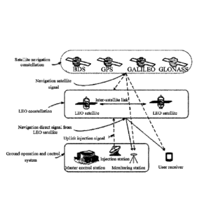
[0067] Fig. 4 is a structural diagram of a navigation augmented
positioning system provided by an embodiment of the present application.
As shown in Fig. 4, the system includes: a LEO constellation, which
provides stable coverage of the world or specific service areas; and a
ground operation and control system, which performs business
calculation and processing, and controls and manages satellites and
constellations; and a user receiver, which receives direct signals of the
navigation satellites and the LEO satellite direct signals, and performs
calculation processing for precise positioning, timing and speed
measurement.
[0068] The LEO satellite constellation (with altitude of 600 km to 1200
km) is configured with high-precision frequency references, receives in
real-time navigation satellite observation information of the GNSS, and
generates and broadcasts the navigation direct signals carrying the
navigation augmentation information; the ground operation and control
system includes a master control station, an injection station, and a
monitoring station; the master control station, the injection station, the
monitoring station and the satellites of the LEO constellation constitute a
satellite-ground integrated system.
[0069] Fig. 5 is a structural diagram of a ground operation and control
system in a navigation augmented system provided by an embodiment of
WSLEGAL\068076\00034\26138293v2
Date Recue/Date Received 2020-12-03
CA 03102490 2020-12-03
the present application. As shown in Fig. 5, the system includes a master
control station, an injection station, and a monitoring station. The
monitoring station collects observation information of GNSS satellites
and the LEO satellites, and sends the collected observation information of
the GNSS satellites and the LEO satellites to the master control station;
the master control station, according to the position information of the
LEO satellites and the monitoring station and various types of
observation information, generates augmentation information of the
navigation satellites, such as the precise orbits and the precise clock
biases and the like, and the precise orbits and the precise clock biases of
the LEO satellites, and after arrangement, forms GNSS augmentation
Information and LEO satellite navigation telegrams, and sends them to
the injection station; the injection station sends the GNSS augmentation
information and the LEO satellite navigation telegrams to the LEO
satellites.
[0070] Fig. 6 is a structural diagram of a master control station of a
ground operation and control system in a navigation augmented system
provided by an embodiment of the present application. As shown in Fig. 6,
the system includes a first calculation unit 601, a second calculation unit
602 and an information arrangement unit 603, wherein the first
calculation unit 601 is configured to calculate precise orbit and precise
clock bias of the GNSS satellite according to its own phisical position
26
WSLEGAL\ 068076\ 00034\ 26138293v2
Date Regue/Date Received 2020-12-03
CA 03102490 2020-12-03
information, the GNSS data collected by the on-satellite receiver of the
LEO satellites, and the observation information of the GNSS satellite and
the LEO satellites; the second calculation unit 602 is configured to
calculate time reference of the system according to its own physical
position information, the GNSS data collected by the on-satellite receiver
of the LEO satellites, and the observation information of the GNSS
satellite and the LEO satellites, and calculate the precise orbits and the
precise clock biases of the LEO satellites and relative clock bias of the
GNSS relative to the system time reference according to the system time
reference; the information arrangement unit 603 is configured to
respectively generate the GNSS augmentation information and the
navigation telegrams of the LEO satellites according to the precise orbit
and the precise clock bias of the GNSS satellite and the precise orbits and
the precise clock biases of the LEO satellites, and send the GNSS
augmentation information and the navigation telegrams of the LEO
satellites to the injection station.
[0071] In an embodiment, the first calculation unit 601 is configured to
construct an observation model of GNSS; according to its own physical
position infoiniation, the GNSS data collected by the on-satellite receiver
of the LEO satellites, and the observation information of the GNSS
satellite and the LEO satellites, perform linearization processing on the
observation model; calculate the linearized observation model by using
27
WSLEGAL\ 068076 \ 00034\ 26138293v2
Date Regue/Date Received 2020-12-03
CA 03102490 2020-12-03
the least square method or filtering, to obtain the precise orbit and precise
clock bias of the navigation satellites.
[0072] The calculation unit 601 is further configured to pre-configure
basic constraint conditions; under the basic constraint conditions,
calculate the linearized observation model by using the least square
method or filtering.
[0073] It should be noted that the operation of the second calculation unit
602 to calculate precise orbits and precise clock biases of the LEO
satellites is similar to the operation of the first calculation unit 601 to
calculate the precise orbit and the precise clock bias of the GNSS, which
will not be described in the embodiment of the present application. For
similarities, please refer to the implementation of the first calculation
unit.
[0074] Regarding the system embodiment, because it is basically similar
to the method embodiment, the description thereof is relatively simple,
and for related parts, please refers to the part of the description of the
method embodiment.
[0075] The navigation augmented method and system provided by the
embodiments of the present application integrate high-, medium- and
low-orbit navigation satellites, and make full use of the advantages, to
ensure that the results of positioning, speed measurement, and timing for
users are continuous, effective, and reliable, and achieve rapid or even
28
WSLEGAL068076 \ 00034\ 26138293v2
Date Recue/Date Received 2020-12-03
CA 03102490 2020-12-03
instantaneous high-precision services in a large-scale range.
29
WSLEGAL\068076\00034\26138293v2
Date Recue/Date Received 2020-12-03