Note: Descriptions are shown in the official language in which they were submitted.
CA 03109097 2021-02-09
WO 2020/056446 PCT/AU2019/000110
1
SYSTEM AND METHOD OF SELECTING A COMPLEMENTARY IMAGE
FROM A PLURALITY OF IMAGES FOR 3D GEOMETRY EXTRACTION
RELATED APPLICATION
pool] The present disclosure claims benefit of priority to U.S. Prov. Pat.
Appl. No. 62/732768
filed 18 September 2018, the contents of which are incorporated herein by
reference. In
jurisdictions where incorporation by reference is not permitted, the applicant
reserves the right
to add any or the whole the contents of said U.S. Prov. Pat. Appl. No.
62/732768 as an
Appendix hereto, forming part of the specification.
FIELD OF INVENTION
[0002] This invention relates to systems and methods for selecting and
prioritizing a set of
images for use for extracting 3D geometry, wherein the geometry extracting
uses a plurality of
images with different perspectives of a point or feature.
BACKGROUND
[0003] Extracting 3D geometry from a plurality of aerial images, taken from
different camera
angles and/or camera locations, is a practical problem of interest in many
applications. One
such application, for example, is the building and construction industry, for
example to provide
information to roofing and solar contractors. Builders, architects, and
engineers may need to
gain an understanding of the roof geometry in 3 dimensions. .
[0004] There has long been a need for using computer technology to carry out
this practical
application, and products for carrying this out are available. It is known,
for example, to use
multi-view imagery such as that captured from a camera system on an aircraft,
a drone, or a
mobile device together with computer technology for this application.
Triangulation methods to
determine location in 30 from a plurality of aerial images are known. For
example, it is known to
determine a particular point in 3D space using aerial images taken of an
object or point on the
ground from different locations and/or angles.
[0005] As used herein, complementary images are images (a) in which a
particular point or
geometric feature of interest is visible, and (b) that yield a solution to
triangulation, thus enabling
extracting geometry. It is known, for example, for a human to identify a point
or region in each of
the complementary images, e.g., using a computer having a user interface
displaying the
images. A 3D point triangulation technique can then yield the 3D coordinates
of a point in 3D
space.
CA 03109097 2021-02-09
WO 2020/056446 PCT/AU2019/000110
2
[0006] If a plurality of such 30 point coordinates are derived using a
triangulation technique,
and these point coordinates correspond to vertices of a planar structure, then
geometry
information of that structure may be inferred, including lengths, slopes,
areas of regions, and so
forth.
[0007] It may be the case that only some but not all of a plurality of
available aerial images
are complementary for a particular triangulation task. It further may be that
not all of the images
are as effective as a complementary image to a selected image. There thus is a
need in the art
for a system ad method that defines one or more measures of suitability of an
image to be
complementary to a selected ("initial") image and to use such one or more
measures to
automatically determine the best complementary images image to the initial
image among the
plurality of available aerial images.
BRIEF DESCRIPTION OF THE DRAWINGS
[0008] The following drawings and the associated descriptions are provided to
illustrate
embodiments of the present disclosure and do not limit the scope of the
invention; the scope is
defined by the claims. Aspects of and advantages of this disclosure will
become more readily
appreciated as these aspects and advantages become better understood by
reference to the
following detailed description, when taken in conjunction with the
accompanying drawings,
wherein:
[0009] FIG. 1 shows a simplified flowchart of a process involving a user
interacting with a
digital processing system for determining one or more geometric features on an
initial image,
including the system carrying out a method of automatically selecting a "best"
complementary
image to the initial image from a provided set of images according to one or
more selection
criteria. The process includes providing for a user a user interface on which
the user may
modify a feature determined using one or more selected complementary images in
order to
repeat the automatically selecting a "best" complementary image until a
satisfactory result is
obtained.
[0010] FIG. 2 shows a simplified schematic of a process for calculating
geometric
complementarily, according to an embodiment of the invention.
[0011] FIG. 3 shows a simplified schematic of an intersection of camera
frustums used as
one viable measure of image overlap, according to an embodiment of the
invention.
CA 03109097 2021-02-09
WO 2020/056446 PCT/AU2019/000110
3
[0012] FIG. 4 shows a simplified schematic of the distance between the
locations of image
centers, which may be used as one viable measure of geographical
closeness/coverage,
according to an embodiment of the invention.
[0013] FIG. 5 shows a simplified schematic of the intersection of a potential
optimal image's
frustum with an estimated volume around a feature of interest. Such an
intersection may be
used as one viable measure of the presence of the feature in the potential
optimal image,
according to an embodiment of the invention.
[0014] FIG. 6 shows a simplified schematic of three cameras denoted 1, 2, and
3, and a user-
selected region of interest denoted R.O.I. The drawing may be used to explain
how angular
deviation and constraints can impact the presence of the feature of interest
in a potential
optimal complementary image according to an embodiment of the invention.
[0015] FIG. 7 shows a simplified schematic of an arbitrary or estimated volume
that can be
created around a feature given complementary 3D information, according to an
embodiment of
the invention.
[0016] FIG. 8 shows example code implementing at least part of an embodiment
referred to
as Embodiment B herein.
[0017] FIG. 9 shows the display on an example user interface in a step of an
example
application of determining the pitch of a roof using an embodiment of the
invention.
[0018] FIG. 10 shows the display on the example user interface in another step
of the
example application of determining the pitch of a roof using an embodiment of
the invention.
[0019] FIG. 11 shows the display on the example user interface in yet another
step of the
example application of determining the pitch of a roof using an embodiment of
the invention.
[0020] FIG. 12 shows the display on the example user interface of a further
step of the
example application of determining the pitch of a roof using an embodiment of
the invention.
[0021] FIG. 13 shows the display on the example user interface of yet a
further step of the
example application of determining the pitch of a roof using an embodiment of
the invention.
[0022] FIG. 14 shows a schematic of an example system architecture with
elements in which
some embodiments of the present invention may operate.
CA 03109097 2021-02-09
WO 2020/056446 PCT/AU2019/000110
4
DETAILED DESCRIPTION OF EXAMPLE EMBODIMENTS
Overview
[0023] Described herein is a system for and method of automatically selecting
one or more
complementary images from a set of provided images for use with triangulation
and
determination of 3D properties of a user-selected point or geometric feature
of interest, such as
information on the slope (also called the pitch) and one or more dimensions of
a roof of a
building. The one or more complementary images are selected automatically by
the method
using an optimality criterion, also called a complementarity criterion herein.
[0024] Particular embodiments include a method, implemented by a digital
processing
system, for selecting complementary images from a plurality of images captured
from distinct
views and/or locations, each respective image captured from a respective
camera having
respective camera properties. The method comprising:
[0025] = accepting the plurality of images, including, for each accepted
image,
parameters related to the accepted image and to properties of the camera that
captured the accepted image;
[0026] = accepting input from a user to select one of the accepted images
to be an initial
image;
[0027] = accepting input from the user indicating one or more geometric
features of
interest; and
[0028] = automatically selecting from the accepted plurality of images and
using an
optimality criterion an optimal image that is complementary to the initial
image for
the purpose of determining one or more 3D properties of the indicated one or
more geometric features.
[0029] In some embodiments of the method. the one or more geometric
features of interest
in the initial image include one of the set of features consisting of a point,
a line, and a surface.
[0030] In some particular embodiments of any of the above described method
embodiments, the automatically selecting includes automatically selecting from
the accepted
plurality of images one or more additional images forming with the optimal
image an optima set,
each image of the optimal set being complementary to the initial image for
determining 3D
properties of the indicated one or more geometric features. Some versions
further include
ranking some or all of the images in the optimal set according to the
optimality criterion, the
CA 03109097 2021-02-09
WO 2020/056446 PCT/AU2019/000110
ranking according to suitability for use as a complementary image to the
initial image, with the
highest ranked image being the optimal image.
[0031] Some versions embodiments of any of the above described method
embodiments
further comprise:
[0032] displaying to the user the optimal image, with the one or more
geometric features of
interest displayed.
[0033] Some of said some versions further comprise:
[0034] = accepting from the user a correction of at least one of the one or
more displayed
geometric features of interest, such that the location of the correction can
be
used for determining one or more geometric properties of the geometric feature
or features of interest; and
[0035] = determining one or more 3D properties of the indicated geometric
feature or
features.
[0036] In some of the above described method embodiments and versions
thereof, the
accepting input from a user to select; the accepting input from the user an
indication, and the
accepting from the user a correction are all via a graphic user interface that
displays images.
[0037] In some particular versions of the any of the above method
embodiments and
versions thereof, the one or more 30 properties include the slope of a roof of
a building.
[0038] Some versions of the any of the above method embodiments and
versions that
include forming the optimal set, further comprise:
[0039] = accepting from the user a selection of one of the other images
from the optimal
set to be a new optimal image;
[0040] = displaying to the user the new optimal image, with the one or more
geometric
features of interest displayed on the new optimal image;
[0041] = accepting from the user a correction of at least one of the one or
more displayed
geometric features of interest on the new optimal image, such that the
location
on the new optimal image of the correction can be used for determining one or
more geometric properties of the geometric feature or features of interest;
and
[0042] = determining one or more 3D properties of the indicated geometric
feature or
features.
CA 03109097 2021-02-09
WO 2020/056446 PCT/AU2019/000110
6
[0043] Some embodiments of any of the above described method embodiments
further
cornprise:
[0044] = accepting an indication from the user of one or more new geometric
features of
interest, which may be the same geometric features earlier selected in the
current initial image, wherein the optimal image after the accepting the
indication
of one or more new geometric features of interest becomes a new initial image;
[0045] = automatically selecting from the accepted plurality of images and
using the
optimality criterion a new optimal image that is complementary to the new
initial
image for the purpose of deter; and
[0046] = displaying to the user the new optimal image, with the one or more
additional
geometric features of interest displayed.
[0047] Furthermore, in some versions of the embodiments described in the
above
paragraph, the automatically selecting includes automatically selecting from
the accepted
plurality of images one or more additional images forming with the optimal
image an optima set,
each image of the optimal set being complementary to the new initial image for
determining 3D
properties of the indicated one or more geometric features. Some such versions
further
comprise ranking some or all of the images in the optimal set according to the
optimality
criterion, the ranking according to suitability for use as a complementary
image to the initial
image, with the highest ranked image being the optimal image.
[0048] Some embodiments of the above described method embodiments that
include
accepting the indication of the one or more new geometric features of interest
further comprise:
[0049] = accepting from the user a new correction of at least one of the
displayed one or
more new geometric features of interest, such that the location of the new
correction can be used for determining one or more geometric properties of the
new geometric feature or features of interest; and
[0050] = determining one or more 3D properties of the indicated new
geometric feature or
features.
[0051] In some embodiments of the above described method embodiments, the
automatically selecting uses as the optimality criterion an overall measure of
complementarity of
the initial image or new initial image and the geometric feature or features,
or new geometric
feature or features to a potential optimal image, the overall measure of
complementarity
including one or more specific measures and corresponding selection criteria.
The one or more
CA 03109097 2021-02-09
WO 2020/056446 PCT/AU2019/000110
7
specific measures include one or more of a measure of the intersection between
frustums, a
measure of coverage, a measure of the intersection between the frustum and an
estimated
extrusion or arbitrary volume, a measure of angular deviation, and a measure
of resolution.
[0052] Particular embodiments include a non-transitory machine-readable
medium
comprising instructions that when executed on one or more digital processors
of a digital
processing systems cause carrying out a method as recited in any one of the
above describe
method embodiments.
[0053] Particular embodiments include a digital processing system
comprising one or more
processors and a storage subsystem, wherein the storage subsystem includes a
non-transitory
machine-readable medium comprising instructions that when executed on one or
more digital
processors of a digital processing systems cause carrying out a method as
recited in any one of
the above describe method embodiments.
[0054] Particular embodiments include a digital processing system
comprising:
[0055] = an input port configured to accept a plurality of images captured
from distinct
views and/or locations, each respective image having been captured from a
respective camera, the accepting including accepting, for each respective
accepted image, respective parameters related to the respective accepted image
and to properties (collectively the "camera model") of the respective camera
that
captured the respective accepted image;
[0056] = a graphical user interface, e.g., in a user terminal having a
display screen and
input subsystem, the graphical user interface able to display an image
displayed
and having an input system for a user to accept input and to interact with a
displayed image;
[0057] = a digital image processing system coupled to the user terminal,
the digital image
processing system including one or more digital processors, and a storage
subsystem that includes instructions that when executed by the digital
processing system, cause the digital processing system to carry out a method
of
selecting one or more complementary images from a plurality of images
accepted via the input port, the method comprising:
[0058] = accepting via the input port the plurality of images and
parameters;
[0059] = accepting e.g., via the graphical user interface input from a
user to select one
of the accepted images to be an initial image;
RECTIFIED SHEET
RO/AU (Rule 91)
CA 03109097 2021-02-09
WO 2020/056446 PCT/AU2019/000110
8
[0060] = accepting e.g., via the graphical user interface input from
the user indicating
one or more geometric features of interest; and
[0061] = automatically selecting from the accepted plurality of images
and using an
optimality criterion an optimal image that is complementary to the initial
image for the purpose of determining one or more 3D properties of the
indicated one or more geometric features.
[0062] In some particular embodiments of the digital processing system,
the one or more
geometric features of interest in the initial image include one of the set of
features consisting of
a point, a line, and a surface.
[0063] In some particular embodiments of the digital processing system,
the automatically
selecting includes automatically selecting from the accepted plurality of
images one or more
additional images forming with the optimal image an optima set, each image of
the optimal set
being complementary to the initial image for determining 3D properties of the
indicated one or
more geometric features.
[0064] In some particular embodiments of the digital processing system
that include forming
the optimal set, the method further comprises ranking some or all of the
images in the optimal
set according to the optimality criterion, the ranking according to
suitability for use as a
complementary image to the initial image, with the highest ranked image being
the optimal
image.
[0065] Some versions of the digital processing system as recited above,
the method further
comprises displaying to the user e.g., on the graphical user interface the
optimal image, with the
one or more geometric features of interest also displayed.
[0066] In one of said some versions, the method further comprises:
accepting e.g., via the
graphical user interface from the user a correction of at least one of the one
or more displayed
geometric features of interest, such that the location of the correction can
be used for
determining one or more geometric properties of the geometric feature or
features of interest;
and determining one or more 3D properties of the indicated geometric feature
or features.
[0067] In some versions of the digital processing system as recited
above, the one or more
3D properties include the slope of a roof of a building.
[0068] In some versions of the digital processing system that include
forming the optimal
set, the method further comprises: accepting from the user e.g., via the
graphical user interface
a selection of one of the other images from the optimal set to be a new
optimal image, and
CA 03109097 2021-02-09
WO 2020/056446 PCT/AU2019/000110
9
displaying to the user e.g., on the graphical user interface the new optimal
image, with the one
or more geometric features of interest displayed on the new optimal image.
[0069] In some of said some versions that include forming the optimal set,
the method
further comprises: accepting from the user e.g., via the graphical user
interface a correction of
at least one of the one or more displayed geometric features of interest on
the new optimal
image, such that the location on the new optimal image of the correction can
be used for
determining one or more geometric properties of the geometric feature or
features of interest;
and determining one or more 30 properties of the geometric feature or
features.
[0070] In some versions of the digital processing system that include
forming the optimal
set, the method further comprises:
[0071] = accepting from the user an indication of one or more new geometric
features of
interest, which may be the same geometric features earlier selected in the
current initial image, wherein the optimal image after the accepting the
indication
of one or more new geometric features of interest becomes a new initial image;
[0072] = automatically selecting from the accepted plurality of images and
using the
optimality criterion a new optimal image that is complementary to the new
initial
image for the purpose of deter; and
[0073] = displaying to the user the new optimal image, with the one or more
additional
geometric features of interest displayed.
[0074] In some versions of the digital processing system described in the
above paragraph,
the automatically selecting includes automatically selecting from the accepted
plurality of
images one or more additional images forming with the optimal image an optima
set, each
image of the optimal set being complementary to the new initial image for
determining 3D
properties of the indicated one or more geometric features. In some of said
some versions the
method further comprises ranking some or all of the images in the optimal set
according to the
optimality criterion, the ranking according to suitability for use as a
complementary image to the
initial image, with the highest ranked image being the optimal image.
[0075] In some versions of the digital processing system as described in
any one of the
above two paragraphs, the method further comprises: accepting from the user a
new correction
of at least one of the displayed one or more new geometric features of
interest, such that the
location of the new correction can be used for determining one or more
geometric properties of
CA 03109097 2021-02-09
WO 2020/056446 PCT/AU2019/000110
the new geometric feature or features of interest; and determining one or more
3D properties of
the indicated new geometric feature or features.
[0076] In some embodiments of the above described digital image processing
system
embodiments, the automatically selecting uses as the optimality criterion an
overall measure of
complementarity of the initial image or new initial image and the geometric
feature or features,
or new geometric feature or features to a potential optimal image, the overall
measure of
complementarity including one or more specific measures and corresponding
selection criteria.
The one or more specific measures include one or more of a measure of the
intersection
between frustums, a measure of coverage, a measure of the intersection between
the frustum
and an estimated extrusion or arbitrary volume, a measure of angular
deviation, and a measure
of resolution.
[0077] Particular embodiments include a digital processing system comprising:
[0078] = means for accepting a plurality of images captured from
distinct views and/or
locations, each respective image having been captured from a respective
camera, the accepting including accepting, for each respective accepted image,
respective parameters related to the respective accepted image and to
properties (collectively the "camera model") of the respective camera that
captured the respective accepted image;
[0079] = means for accepting input from a user, wherein said means for
accepting is
configured to accept input from a user to select one of the accepted images to
be an initial image, and to accepting input from the user indicating one or
more
geometric features of interest; and
[0080] = means for automatically selecting from the accepted plurality
of images and
using an optimality criterion an optimal image that is complementary to the
initial
image for the purpose of determining one or more 3D properties of the
indicated
one or more geometric features.
[0081] In some versions of the digital processing system of the above
paragraph, one or more
geometric features of interest in the initial image include one of the set of
features consisting of
a point, a line, and a surface.
[0082] In some versions of the digital processing system of any one of the
above two
paragraphs, called the optimal set embodiments, the means for automatically
selecting is also
configured to automatically select from the accepted plurality of images one
or more additional
RECTIFIED SHEET
RO/AU (Rule 91)
CA 03109097 2021-02-09
WO 2020/056446 PCT/AU2019/000110
11
images forming with the optimal image an optima set, each image of the optimal
set being
complementary to the initial image for determining 3D properties of the
indicated one or more
geometric features.
[0083] In some versions of the digital processing system described in the
above paragraph,
the means for automatically selecting further is configured to rank some or
all of the images in
the optimal set according to the optimality criterion, the ranking according
to suitability for use
as a complementary image to the initial image, with the highest ranked image
being the optimal
image.
[0084] Some particular embodiments of the digital processing system described
in any one of
the above four paragraphs (called "the basic four paragraphs") further
comprise means for
displaying an image and other information to the user, configured to display
to the user the
optimal image and the one or more geometric features of interest.
[0085] In some versions of the digital processing system described in the
above paragraph,
[0086] = the means for accepting from the user accepting from the user a
correction of at
least one of the one or more displayed geometric features of interest, such
that
the location of the correction can be used for determining one or more
geometric
properties of the geometric feature or features of interest; and
[0087] = the means for automatically selecting further is configured to
determine one or
more 3D properties of the geometric feature or features of interest.
[0088] In some versions of the digital processing system of the above
paragraph, the one or
more 3D properties include the slope of a roof of a building.
[0089] In some versions of the optimal set embodiments,
[0090] the means for accepting is further configured to accept from the
user a selection of
one of the other images from the optimal set to be a new optimal image;
[0091] the means for displaying is further configured to display to the
user the new optimal
image, with the one or more geometric features of interest displayed on the
new optimal image.
[0092] the means for accepting is further configured to accept from the
user a correction of
at least one of the one or more displayed geometric features of interest on
the new optimal
image, such that the location on the new optimal image of the correction can
be used for
determining one or more geometric properties of the geometric feature or
features of interest;
and
CA 03109097 2021-02-09
WO 2020/056446 PCT/AU2019/000110
12
[0093] the means for automatically selecting is further configured to
determine one or more
3D properties of the geometric feature or features.
[0094] Some versions of the digital processing system described in any one of
the basic four
paragraphs comprise means for displaying an image and other information to the
user,
configured to display to the user the optimal image and the one or more
geometric features of
interest, wherein:
[0095] the means for accepting is further configured to accept from the user
an indication of
one or more new geometric features of interest, which may be the same
geometric features
earlier selected in the current initial image, wherein the optimal image after
the accepting the
indication of one or more new geometric features of interest becomes a new
initial image;
[0096] the means for automatically selecting is further configured to
automatically select
from the accepted plurality of images and using the optimality criterion a new
optimal image that
is complementary to the new initial image for the purpose of deter; and
[0097] the means for displaying is further configured to display to the
user the new optimal
image, with the one or more additional geometric features of interest
displayed.
[0098] In some versions of the digital processing system as described in the
above
paragraph, the means for automatically selecting is further configured to
automatically select
from the accepted plurality of images one or more additional images forming
with the optimal
image an optima set, each image of the optimal set being complementary to the
new initial
image for determining 3D properties of the indicated one or more geometric
features.
[0099] In some versions of the digital processing system as described in the
above
paragraph, the means for automatically selecting further is configured to rank
some or all of the
images in the optimal set according to the optimality criterion, the ranking
according to suitability
for use as a complementary image to the initial image, with the highest ranked
image being the
optimal image.
[00100] In some versions of the digital processing system in which the means
for accepting is
further configured to accept from the user an indication of one or more new
geometric features
of interest,
[00101] the means for accepting is further configured to accept from the user
a new
correction of at least one of the displayed one or more new geometric features
of interest, such
that the location of the new correction can be used for determining one or
more geometric
properties of the new geometric feature or features of interest; and
CA 03109097 2021-02-09
WO 2020/056446 PCT/AU2019/000110
13
[00102] the means for automatically selecting is further configured to
determine one or more
3D properties of the indicated new geometric feature or features.
[00103] In some embodiments of the above described digital image processing
system
embodiments that include the means for automatically selecting, the
automatically selecting
uses as the optimality criterion an overall measure of complementarity of the
initial image or
new initial image and the geometric feature or features, or new geometric
feature or features to
a potential optimal image, the overall measure of complementarity including
one or more
specific measures and corresponding selection criteria. The one or more
specific measures
include one or more of a measure of the intersection between frustums, a
measure of coverage,
a measure of the intersection between the frustum and an estimated extrusion
or arbitrary
volume, a measure of angular deviation, and a measure of resolution.
[00104] Particular embodiments may provide all, some, or none of these
aspects, features, or
advantages. Particular embodiments may provide one or more other aspects,
features, or
advantages, one or more of which may be readily apparent to a person skilled
in the art from
the figures, descriptions, and claims herein.
Description in more detail
[00105] Embodiments of the present invention include a method of automatically
selecting
images for 3D measurements of feature(s) of interest in an initial image.
[00106] FIG. 1 shows a simplified flowchart of a machine-implemented method
embodiment of
the invention. The method is of operating a digital processing system such as
that shown in
FIG. 14, which shows a schematic of an example system architecture 1400 with
elements in
which embodiments of the present invention operate. The
elements 1401, 1431, 1441, 1451, 1481 are shown coupled via a network 1491,
but in other
alternate embodiments need not be so coupled. In some embodiments of the
invention
network 1491 is a public internetwork, in particular embodiments the Internet.
These
elements 1401, 1431, 1441, 1451, 1481 therefore can be considered part of the
network 1491.
[00107] In general, the term "engine" as used herein refers to logic embodied
in hardware or
firmware, or to a collection of machine-executable instructions. Such
executable instructions
may originally be written in a programming language and compiled and linked
into an
executable program of the machine-executable instructions. It will be further
appreciated that
hardware engines may be comprised of connected logic units, such as gates and
flip-flops,
and/or may be comprised of programmable units, such as programmable gate
arrays or
processors.
RECTIFIED SHEET
RO/AU (Rule 91)
CA 03109097 2021-02-09
WO 2020/056446 PCT/AU2019/000110
14
[00108] In one embodiment, images are captured by a camera system 1441 and
transmitted
over the network 1491 to an image storage server 1481 wherein the captured
images 1489 are
stored with camera parameters such as the camera identity, the camera
location, a timestamp
for the image, the camera orientation/rotation, the camera resolution, and
other camera
parameters, the collection of all the parameters called the camera model
herein. In one
embodiment, the camera is mounted on an airplane or UAV (unmanned aerial
vehicle). One
such camera is described in U.S. Pat. No. 9641736 assigned to the Applicant of
the present
invention, and in parent patents of said US9641736. Of course, the images used
in
embodiments of the invention are not limited to those obtained by one or such
cameras. Any
other camera may be used.
[00109] In some embodiments, the images and camera models 1489 are assumed
already to
have been accepted by system 1400 and stored in the image storage server 1481,
so no
camera is part of the system when operating. The image storage server includes
one or more
digital processors (not explicitly shown) and a storage subsystem 1487 that
includes memory
and one or more other storage elements, and instructions in storage subsystem
1487 that when
executed carry out the functions of the image storage server 1481.
[00110] One or more images and their respective camera models are accepted,
e.g., via the
network 1491 and an input port such as a network interface into a digital
image processing
system 1431 that carries out respective method steps described herein
according to program
instructions in storage, e.g., 1435 in storage subsystem 1433 executable by at
least one
processor 1432 of the digital image processing system 1431. Storage subsystem
1433 includes
memory and one or more other storage elements.
[00111] The image processing system may be partitioned into separate engines.
[00112] In one embodiment, a user interacts with the digital image processing
system on a
client digital processing system 1401 that includes one or more digital
processors 1402, a
display 1407, a storage subsystem 1403 (including memory), and one or more
user input
devices 1406 that form a subsystem that enables the user to select and display
an image, and
to point to and/or draw one or more geometric features in a displayed image.
The functions
carried out by the client digital processing system 1401 are carried out by
executing
instructions 1408 stored in storage subsystem 1403. Users may operate the
client digital
processing system 1401 via respective user interfaces (U1s). The Uls are
optionally presented
(and the user's instructions may be received) via the client digital
processing system 1401 using
a browser, other network resource viewer, a dedicated application, or other
input means. In
general, a person (a user) may enter information into the client digital
processing system by at
CA 03109097 2021-02-09
WO 2020/056446 PCT/AU2019/000110
least one of: hovering over, pointing at, or clicking on a particular item,
providing verbal
instructions via a microphone, the person may touch a touch screen, and the
person may
otherwise provide information. Thus, one or more user interfaces may be
presented on user
digital processing system 1401. System 1401 may be a laptop computer, a
desktop computer, a
user terminal, a tablet computer, a smart phone, or another terminal type. The
user input
device(s) may include one or more touch screens, microphones, touch pads,
keyboards, mice,
styluses, cameras, and so forth.
[00113] Note that the elements shown in FIG. 14 are representative. In some
embodiments,
the digital image processing system may be operating in the Web, e.g., as one
or more Web
agents, so while such agents include program instructions (shown as 1435) and
such
programming instructions operate on machines, the machines are not necessarily
partitioned as
individual digital processing systems as shown in FIG. 14. Furthermore, the
machines may be
virtual machines instantiated in the cloud. Similarly, the image storage
server may be provided
as a Web service in the cloud.
[00114] In other embodiments, the functionality of the image storage server
may be
incorporated in the digital image processing system 1431 using storage
subsystem 1433 for
storing the captured images and metadata 1489.
[00115] Furthermore, in other embodiments, the image processing system may be
partitioned
into separate engines configured to carry out a specific set of steps,
including a geometry
engine that carries out, inter alia, triangulation and geometrical
calculations, a selection
(complementarity) engine that calculates the measures of complementarity and
the overall
measure of cornplementarity, and selects one or more optimal images.
[00116] One skilled in the art would understand that the arrangement shown in
FIG. 14 is only
one possible arrangement of a system that can operate according to the
flowchart of FIG. 1. For
example, the system need not operate over a network, and fewer elements may be
used. For
example, the functionality of the client digital processing system 1401, the
digital image
processing system 1433, and the image storage server 1481 may be combined into
a single
digital processing system that includes one or more digital processors, a
storage subsystem, a
display, and one or more user input device(s).
[00117] Returning to the flowchart of FIG. 1, step 103 includes accepting a
plurality of images
that were taken from distinct camera locations and/or distinct camera
orientations, and
accepting the respective camera models for the accepted images. At least some
of the
accepted images are displayed to a user on a user interface that includes
providing the ability
CA 03109097 2021-02-09
WO 2020/056446 PCT/AU2019/000110
16
for the user to select an image, and a pointing subsystem system for the user
to select one or
more geometric features of interest, such as a point, a line, an area, and so
forth.
[00118] One or more of the accepted images are displayed to the user, and the
user selects an
image that shows a region of interest to the user. In some embodiments, the
image is simply
one of the images on which the user can indicate the region of interest, and
then the method, in
105, accept from a user an indication of an initial image, e.g., one that has
a good view of one
or more points of interest to the user, and displays the initial image and
points of interest.
[00119] In one embodiment, the presenting to a user of the initial image is on
the display 1407
of the client digital processing system (operating as a user terminal) that
includes a graphical
user interface. A set of instructions carried out on client digital processing
system carries out the
presenting of the user interface, the accepting of data input to the user
interface, and other
interactions with the user. Many of the other steps of the flow chart of FIG.
1 are carried out on
the digital image processing system 1431.
[00120] Each of the steps 107 through 119 may be accompanied by instructions
presented to
the user via the user interface to guide the user's actions. Such instructions
may explicitly
request the user to select points or draw lines (or form other geometric
shapes) in a specific
image, such as for example in an image presented to the user as "primary view"
(e.g., the initial
image), "secondary view", "tertiary view" or other specifically identified
image.
[00121] Step 107 includes accepting from the user a selection of one or more
2D points (pixels
or interpolated points) in the initial image (or a selected one or more
images). A group of such
points may be designated to represent a geometric entity in 3D such as a line,
one or more
triangles, and so forth. Step 107 includes displaying the user selection on
the initial image.
[00122] Step 109 includes calculating, e.g., in the digital image processing
system 1431, or, in
some embodiments, in a separate selection (complementarity) engine, one or
more selection
measures for the initial image in relation to at least some of the accepted
images and their
respective camera models. The selection measures correspond to selection
criteria that may be
used to select and rank images according to their respective geometric
complementarity, used
herein to mean a measure of suitability as a complementary image to the
initial image. Thus,
some images of the provided plurality of images may be complementary to the
initial image,
with one having the highest complementarity.
[00123] The at least some the accepted images may be preselected from the
available
accepted captured images according to relevance to the initial image, e.g.,
the geographic
location of the captured images so that the at least some the accepted images
includes only
CA 03109097 2021-02-09
WO 2020/056446 PCT/AU2019/000110
17
images that include the user's selection of point(s) of interest on the
initial image. In some
embodiments, in addition, some of the images may also be explicitly excluded
by the user, e.g.,
because the images fail some measures of image quality such as insufficient
resolution,
insufficient sharpness, too much noise, and so forth. In some embodiments,
additionally or
alternatively, some of the images may be excluded because of measures of
presence of
undesirable artifacts in the image, such as presence of obstructions of views
of one or more
points of interest in the image.
[00124] Thus, in step 109, each of the selection measures are used to
calculate corresponding
selection criteria that use one or more image characteristics that are
relevant to determining
whether or not an image is complementary to the initial image, so that Step
111 of automatically
selecting a set of one or more images from the provided plurality of images
can be carried out.
[00125] Step 111 includes automatically selecting an image from the at least
some the
accepted images using the selection criteria determined in Step 109 to form
the image that is
most suitable as a complementary image to the initial image according to a
measure of
complementarity based on the selection criteria. We call such a most suitable
image the optimal
image. In some embodiments, While in one embodiment, only a single image, the
one that is
truly optimal in complementarity, is selected, in other embodiments, step 111
includes
automatically selecting at least one other image from the provided images to
form what we call
an "optimal set" of suitable images, such set including the optimal image.
Such an embodiment
may include ranking the images of the optimal set according to the measure of
complementarity
based on the selection criteria. In one embodiment of the invention, the
automatic selection in
Step 111 is based on carrying out optimization of the selection criteria
calculated in Step 109. .
[00126] Note that in some embodiments, a subset of characteristics and
measures is chosen
to successfully measure the complementarity of an image depending on the use
case and
data/characteristics available.
[00127] In some embodiments, step 111 includes automatically calculating the
locations on the
optimal image of the user's selection of point(s) of interest on the initial
image. This also may be
carried out as a separate step.
[00128] Step 111 is carried out in the digital image processing system 1431,
or, in some
embodiments, in a separate selection (complementarity) engine.
[00129] Step 113 includes the method visually presenting to the user the
optimal image,
together with the user's selection of point(s) of interest, such that the user
can correct the
location n the optimal image of the user's selection of point(s) of interest
to correspond to
CA 03109097 2021-02-09
WO 2020/056446 PCT/AU2019/000110
18
geometric feature(s) of interest. For example, in one practical application,
the user's selection of
points of interest may be on the corner's of a planar roof panel in the
initial image. These points,
when calculated on the optimal image, may no longer be at the edge of the roof
panel.
[00130] In some embodiments, not only the optimal image, but a subset of one
or more
images, or all images of the optimal set of suitable images are presented to
the user on the user
interface. We call these one or more images a "selected subset" of suitable
images.
[00131] In the following, assume only the optimal image is presented to the
user. Consider the
optimal image being presented together with the user-selected geometric
feature(s) of interest
such that the user can correct the location of geometric feature(s) of
interest.
[00132] At this stage, in some embodiment, the user may not be satisfied with
the optimal
image selected, e.g., because of the angle or location of the user-selected
geometric feature(s)
of interest. In such embodiments, the user may desire another image to be the
optimal image,
e.g., one of the other images of the selected set or complete optimal set).
This is shown as
decision block 115 notated "User satisfied?", and, responsive to the user not
being satisfied (the
"No" branch), the user selecting and, in step 117, the method accepting from
the user the user's
selection of a new optimal image. The method then returns to step 113 using
the user selected
new optimal image.
[00133] In Step 119, the user interface accepts from the user an
identification and/or a
refinement ("user action(s)") of one or more corresponding points of the
represented geometric
entity, and displays to the user the accepted identification and/or
refinement. In the planar roof
example, the user interactively corrects the locations of the two points that
for the line edge of
the planar roof.
[00134] In Step 121, calculations are carried out, e.g., in the digital image
processing system
1431, of corresponding results of the accepted user action(s) to the location
of the one or more
corresponding points of the represented geometric entity, including carrying
out 3D triangulation
calculations in the optimal image (or, in some embodiments, in one or more of
the images from
the selected subset). The calculations include determining properties of the
geometric entity,
e.g., the 3D slope (pitch) and length of a line, the surface area of a planar
object, and so forth.
Step 121 further includes displaying the corresponding results on the graphic
display of the
optimal image (or one or more of the images from the selected set), including
the calculated
properties, e.g., one or more of line length(s), slope/pitch, and other one or
more applicable
parameters of the represented geometric entity.
CA 03109097 2021-02-09
WO 2020/056446 PCT/AU2019/000110
19
[00135] Note that in alternate embodiments, once the optimal image is
displayed to the user
(113), the user may select to return to step 107 with the optimal image now a
new initial image,
and in step 107 cause the method to accept from the user further points, e.g.,
additional
endpoints making one or more additional lines. The old optimal image is the
new initial image
and step 109 proceeds with the newly added further points.
A simplified block diagram
FIG. 2 shows a simplified block diagram of the data flow of an embodiment of
the invention. The
image set includes an unordered set 205 of images and an initial image 207. A
selection
(complementarity) engine 203 uses selection criteria based on the set of
selection measures. In
some embodiments, the selection (complementarity) engine 203 is implemented in
the image
processing system 1431. These selection measures may include, along with the
camera model
described above, angle constraints 209 in heading, pitch, and roll, the
constraints denoted as
OH, Op, and OR, respectively. Note that in this context, in some embodiments,
pitch refers to the
angle from the horizon to the ground. Thus, if the camera pointed directly
down. e.g., forming an
image of the top of a house, then the image has a pitch of 90 degrees. One the
other hand, an
image of the horizon would have a pitch of 0 degrees; In some such
embodiments, heading
means the angle with respect to due north, such that if a camera pointing
straight down takes
an image, the image, for example of the top of a building is at 90 degree
heading, while an
image of the horizon is at 0 degree heading.
[00136] Also used in some embodiments are complementary 3D and/or Z-axis data
211 (which
may be of a "2.5D" variety) such as a digital surface model (DSM), and/or mesh
data (e.g., as
triangle surfaces). The results determined by the selection (complementarity)
engine 203 may
include an ordered set 213 of images, the ordering according to the overall
measure of
complementarity, or in some embodiments, the single optimal image.
Geometric complementarity measures, criteria and input parameters
Terminology
[00137] The initial image 207 is the first image in which a feature is
selected or which
contains a point of interest. An "initial camera model" includes a set of
characteristics that
describe the apparatus (called a camera herein) used to capture the initial
image. The "optimal
image" is the highest scoring (most complementary) image for the initial image
207. The
"optimal camera model" is a set of characteristics that describe the apparatus
used to capture
the "optimal image." The "image set" 205 is all available images excluding the
initial image.
CA 03109097 2021-02-09
WO 2020/056446 PCT/AU2019/000110
The optimal set 213 is a set of images ranked according to a complementarity
score for the
initial image 207.
Camera and other apparatus characteristics
[00138] The "camera model" for a particular image includes the location of the
camera system
at time of capture (e.g. easting, northing, altitude, UTM coordinates), the
rotation and orientation
(e.g. heading, pitch, and roll) of the camera system at time of capture, and
the resolution of the
camera system used, and may include the lens distortion model of the camera
system used and
the sensor type and shape of the camera system used. Similarly, a "specific
viewport" may be
used to describe a local portion of the image, which could be described by
zoom, or a local
boundary within the image in pixels. Note that a "lens distortion model" may
be a function of
multiple camera sensor and lens characteristics.
[00139] Other complementarity properties that may be used pertaining to the
image that may
have been determined via other means include the estimated ground height, the
maximum
height of the user-selected feature, digital surface model (DSM) or known
feature geometries in
similar or same locations.
Selection measures and criteria
[00140] The selection (complementarity) engine 203 of FIG. 2 in one embodiment
uses a set of
selection criteria, each using corresponding selection measures used to
determine geometric
complementarity of images, e.g., of the initial image and its user-selected
geometric feature(s)
of interest to a potential optimal image. The corresponding selection measures
used in the
selection criteria include at least some, in some embodiments all, and in yet
other embodiments
just one of the measures and corresponding selection criteria described below.
Measure/criteria of the intersection between frustums
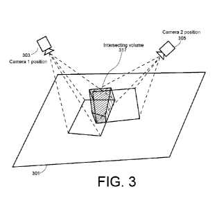
[00141] FIG. 3 shows a simplified drawing of an intersection of camera
frustums used as a
viable measure of image overlap, according to an embodiment of the invention.
This is included
in f1 (intersection) shown in engine 203 of FIG. 2, which shows two camera
positions 303 and
305, the capture areas 313 and 315 on a surface 301, typically the ground, and
an intersection
volume 317 of the two camera frustums over the overlap of areas 313 and 315,
such the
intersection volume forms a measure of the overlap. Such measure is obtained
by calculating
the intersection volume 317 formed by the initial camera model frustum and
camera model
frustum of the potential optimal image (called the potential optimal camera
model frustum), by
projecting each camera position's lens bounds (rays) onto the surface 301
containing a user-
selected geometric feature (not shown in FIG. 3) and determining where they
overlap, and/or by
CA 03109097 2021-02-09
WO 2020/056446 PCT/AU2019/000110
21
what percentage they overlap, and/or the total intersection volume. The
formulae for such an
intersection can be determined using straightforward geometry, as would be
known to those in
the art, and as taught inter alia in computer graphics courses. See for
example Y. Zamani, H.
Shirzad and S. Kasaei, "Similarity measures for intersection of camera view
frustums," 2017
10th Iranian Conference on Machine Vision and Image Processing (MVIP),
Isfahan, 2017, pp.
171-175. Examples of use of such formulae can also be found in: S. Hornus, "A
review of
polyhedral intersection detection and new techniques," [Research Report] RR-
8730, INRIA
Nancy - Grand Est (Villers-les-Nancy, France), pp. 35; 2015; in M. Levoy, "A
hybrid ray tracer
for rendering polygon and volume data," TR89-035, The University of North
Carolina at Chapel
Hill Department of Computer Science, 1989; and in G.T. Toussaint, "A simple
linear algorithm
for intersecting convex polygons," The Visual Computer, August 1985, Vol. 1,
No. 2, pp 118-
123.
[00142] One embodiment of the invention uses as a criterion based on the
measure of the
intersection between frustums as follows: the greater the overlap between the
frustums of the
initial image and the potential optimal image, the greater the chance that the
feature is included
in the potential optimal image.
Measure/criteria of coverage
[00143] Another selection measure is a measure of geographical closeness or
coverage. This
is also included in the function f1 (intersection) shown in engine 203 in FIG.
2. In one
embodiment, this measure is determined by calculating the distance between the
locations of
the center pixel of each image obtained by a respective camera once the images
have been
projected onto a surface. FIG. 4 shows a simplified schematic of two
overlapping images
obtained by two cameras 403 and 401, labeled camera 1 and camera 2,
respectively the
images having respective center pixels at surface location 411 and surface
location 413,
respectively. One measure of closeness is the distance 415 between the two
centers. Another
measure, but equally viable, is the 20 overlap 417 (coverage) of one image
over another on the
projected surface, in terms of area of percentage, a measure known to those
skilled in the art.
Another measure of closeness is the calculated distance between the location
of the user-
selected feature in the initial image and the center pixel location of each
image that may be a
complementary image. The formulae for such distance may be determined using
straightforward geometry, and such calculations would be known to those in the
art.
[00144] In the code below, we define
distance = surface location2 ¨ surface location1,
where distance and the surface locations are 20 or 30 vectors.
CA 03109097 2021-02-09
WO 2020/056446 PCT/AU2019/000110
22
[00145] One embodiment of the invention uses as a criterion based on the
measure of
coverage, stating that: the smaller the distance between the locations
described by the initial
image center pixel or feature in the initial image and the potential "optimal
image" center pixel,
the higher the "coverage" of the potential optimal image over the initial
image, and therefore the
higher the chance the feature is included in the potential optimal image.
Measure/criteria the intersection between frustum and estimated extrusion
[00146] Another selection measure is the measure of intersection between the
frustum and an
estimated extrusion or arbitrary volume. It is highly likely that the user-
selected feature of
interest will not lie exactly on the 2D plane represented by a potential
complementary image, in
that a non-planar feature that was planar on the initial image may extrude out
of the plane, or be
elevated off the plane in another image of the image set. Therefore, there
will be a volume
surrounding the feature that may extend in a particular direction, or be of a
particular shape,
unrelated to the frustum of the camera models of the initial and potential
optimal image. The
optimal image's frustum should maximise the intersection of this arbitrary
volume surrounding
the user-selected feature of interest. This measure is determined as the
intersection between
the potential optimal image's frustum intersecting with the arbitrary volume.
FIG. 5 shows as a
simplified schematic one camera 505 (a second camera is not shown) and an
intersecting
volume between the frustum and an arbitrary volume 507 that is around an
estimated volume
that includes the feature of interest. How to determine such an intersecting
volume uses
straightforward geometry, and the formulae for such are the same as for the
measure of the
intersection between frustums. If used, this measure is also included in
fi(intersection) in
engine 203 of FIG. 2.
[00147] One embodiment of the invention uses as a criterion based on the
measure of frustum
and estimated extrusion intersection that: the greater the intersection
between the potential
optimal image frustum and the estimated/arbitrary volume surrounding the
feature, the greater
the chance that the feature is included in the potential optimal image.
Measure/criteria of angular deviation
[00148] Another measure is that of angular deviation. In some applications,
the requirements
of the application may lead to an acceptable range of or to constraints on the
rotation and
orientation characteristics of the camera models. The determining of an
optimal image by the
selection (complementarity) engine 203 may accommodate such ranges or
constraints. Angular
deviation, called angle constraints and denoted OH, Op, and OR for heading,
pitch, and roll in
FIG. 2, can be measured and constrained in many ways, for example by using
visual acuity
CA 03109097 2021-02-09
WO 2020/056446 PCT/AU2019/000110
23
measures described below, by simply measuring the rotational parameter of the
camera
apparatus, and/or by providing application specific constraints.
[00149] Essentially, the measure of angular deviation is a measure of "visual
acuity," which is
the spatial resolving capacity of a visual system. See for example M.
Kalloniatis, C. Luu, "Visual
Acuity," In: Kolb H, Fernandez E, Nelson R, editors, Webvision: The
Organization of the Retina
and Visual System [Internet]. Salt Lake City (UT): University of Utah Health
Sciences Center;
1995, last modified 5 June 2007, available at
webvision-dot-med-dot-utah-dot-edu/book/part-viii-gabac-receptors/visual-
acuity/,
retrieved 11 Sep. 2018, where -dot- denoted the period (".") character in the
actual URL. This
Kalloniatis and Luu paper describes a measure of "Minimum Angle of
Resolution," "Angular
Resolution," or "MAR", defined as the minimum angle of separation such that an
optical
instrument can resolve two points that are close together in two distinct
objects, and would
describe to one skilled in the art, an obvious constraint in resolving two
points in 3D space,
particularly in terms of accuracy, but also occlusion.
[00150] Two such functions for spatial and for angular resolution may be, for
example:
[00151] Angular resolution = 1.220 x (wavelength of light! diameter of lens
aperture);
Spatial resolution = 1.220 x ( (focal length x wavelength of light) / diameter
of light beam ) ).
[00152] See for example the Wikipedia article "Angular Resolution," at
en-dot-wikipedia-dot-orq/wiki/Anqular resolution, last modified 25 June 2018,
retrieved 11
Sep. 2018, where -dot- denoted the period (".") character in the actual URL.
[00153] FIG. 6 shows as a simple schematic three cameras denoted camera 1 603,
camera 2
605, and camera 3 607, and a user-selected region of interest 621 denoted ROI.
The angle 611
between camera 1 and camera 2 is denoted A012, and that between camera 2 and
camera 3 is
denoted A02.The above visual acuity calculations may apply to the heading,
pitch or roll of the
system (OH, Op, and AR), or any other measure of angular change between two
images.
Formulae for determining angular constraints would be known to those in the
art, and available
in the references provided above.
[00154] Another angular constraint that may be used in some embodiments of the
invention is
related to a limitation in the particular camera system in which the oblique
(multi-view) imagery
is captured in such embodiments. The images from such cameras are along the
cardinal
directions of North, South, East and West, which means a minimum 90 degree
separation for
some views. This provided a particular case of angular constraint, whereby the
user of the
CA 03109097 2021-02-09
WO 2020/056446 PCT/AU2019/000110
24
graphical user interface might become disorientated, and therefore unable to
identify a feature
of interest. Consider, for example, a case that the view was to switch by 90
degrees to another
cardinal direction. The rotation of the feature of interest may, to the user,
have been distorted in
such a way that the user cannot easily comprehend the feature's geometry.
Therefore, in some
embodiments, a purely user-provided and non-mathematical constraint is applied
such that the
system is weighted to give higher priority to images taken the same cardinal
direction as the
initial image.
[00155] One embodiment of the invention uses as a criterion based on the
measure of angular
deviation that the more the angular deviation fits into the range or
constraints provided, between
the initial image and the potential optimal image, the greater the chance that
the feature will be
visible in both images, and that the viewport is acceptable for the particular
use case.
[00156] The measures of angular deviation in heading, pitch, and roll are
shown as
f2(ang_dev_H), f3(ang_dev_P), and f4(ang_dev_P), respectively, in engine 203
of FIG. 2.
Measure/criteria of resolution
[00157] A fifth measure is a measure of resolution, shown as f5(resolution) in
FIG. 2. Given
that the projection of the image onto the surface results in a particular
resolution, the
identification of a point in multiple images, and the accuracy of the
identification or geometry
extraction will also be resolution dependent, where accuracy is a function of
resolution, focal
length and distance from the camera sensor to the point of interest.
Resolution also has a direct
impact on the angular deviation constraints and angular resolution equations
described above.
Resolution can be measured in a system in many ways, but some such examples
include GSD,
or pixel density. Resolution can be constrained in many ways, described
mathematically for
example by using a clamp function, constraint function, a filter function, or
a range function to
determine the suitability of certain resolutions. Formulae for such functions
would be known to
those in the art, and available in the references provided:
[00158] One such measure of resolution is that of Ground Sampling Distance
(GSD), which is
a measure of the distance one pixel will cover on the plane the image is
projected upon (usually
onto some known ground height). Formulae for determining a GSD would be known
to those in
the art. One example is.
[00159] GSD = Pixel Size x (Elevation above ground / focal length).
CA 03109097 2021-02-09
WO 2020/056446 PCT/AU2019/000110
[00160] A smaller GSD indicates a greater resolution. In some embodiments of
the invention,
priority is given priority to images wherein the GSD is less than or equal to
the GSD of the initial
image.
[00161] One embodiment of the invention uses as a criterion based on the
measure of
resolution that: the greater the resolution of the potential optimal image
meets the resolution
range or constraint, the greater the ability for the feature to be visible,
and the more accurately
the feature is identified.
[00162] In some embodiments, the overall measure of complementarity used by
the selection
(complementarity) engine 203 to select and rank images is.
[00163] Complementarity=Z{ (intersection)+f2(ang_dev_H) )+ f3(ang_dev_P)+
f4(ang_dev_P)+f5(resolution)}.
General geometric analysis process
[00164] The following steps describe one embodiment of a process of geometric
analysis used
by the selection (complementarity) engine 203 to select and rank images
according to a
measure of optimality (i.e., measure of complementarity). Note that while
these steps are called
first step, second step, etc., no order of these steps being carried out is
implied.
[00165] In one embodiment of the invention, a first step includes selecting
camera and other
apparatus characteristics that are used. In this step, all or a subset of the
apparatus
characteristics described in the "Camera and other apparatus characteristics"
subsection above
are selected depending on the particular use case.
[00166] A second step includes creating a weight function of how each of the
selection criteria
and characteristics that are used are to be weighted in the overall optimality
criterion, such a
weight function, e.g., a set of weights, being based on the requirements of
the particular
application. As an example, for purpose of triangulation one would give a
higher weight to the
angular deviation of the images in order to give preference to greater
difference in the pitch of
the capture apparatus so as to accurately resolve a selected point or
geometric feature(s) of
interest.
[00167] The following example of a method of creating weight functions in one
particular
embodiment. The method comprises sorting the images by complementarity score
to the initial
image, e.g., as the sum of the position score, heading deviation score, and
the pitch score. For
the position score, the method add 1 point for every 200 meters from perfectly
cantered, where
CA 03109097 2021-02-09
WO 2020/056446 PCT/AU2019/000110
26
perfectly centered means the center of the line of interest formed from two
user selected points
is situated at the center of the image. For the heading deviation (difference
in degrees) score,
the method determines the heading difference (in degrees) from the heading of
the initial image,
and deletes one point for every 22.5 degrees of heading deviation. In some
embodiments,
heading is the angle with respect to due north, so that, for example, if the
image is of a southern
facing wall of a house, the camera would have been due north, such that the
heading would be
0 degrees. For the pitch difference score, the method adds 1 point for every
22.5 degrees of
pitch difference (deviation) between the image pitch and the pitch of the
initial image, where, in
some embodiments, the pitch is the angle from the horizon to the ground, so
that, for example
in some embodiments, if you were looking at an image of the top of a house
(with the camera
pointed directly down), then the image has a pitch of 90 degrees, while an
image of the horizon
would have a pitch of 0 degrees.
[00168] In some embodiments, the weight function creation method further
comprises
removing any image where that is too similar in angle to the initial image.
One version uses as
the criterion for too similar that the sum of the heading angle deviation and
the pitch angle
deviation is less than or equal 20 degrees. The weight function creation
method further
comprises removing any images where any part of the line (in the case of two
endpoint being
indicated) falls outside of the image. For this step, the ratio, e.g., as a
percentage of volume of
intersection of each potential optimal image's frustum volume intersecting
with the initial image's
frustum volume versus the volume created by the initial image frustum. This
intersection
percentage and the camera rotation angles are scored and weighted using the
weight function
to determine the optimality criterion for each potential optimal complementary
image.
[00169] A third step includes selecting an initial image and accepting into
the digital processing
system the initial image's characteristics. This corresponds to step 105 in
the flowchart of
FIG. 1.
[00170] A fourth step includes, for each potential optimal image in the image
set, using such
each image's characteristics to calculate a value for each of the measures
used (from the above
five selection measures). Each calculated measure is multiplied by the
corresponding weight
using the created weight function.
[00171] A fifth step includes summing the weighted measures or characteristics
for each
potential optimal image in the image set to form such image's optimality
criterion.
[00172] A sixth step includes ordering (ranking) the potential optimal images
in the image set
according the optimality criterion, and selecting the top ranked image as the
optimal
CA 03109097 2021-02-09
WO 2020/056446 PCT/AU2019/000110
27
complementary image for the chosen initial image and selected geometric
feature(s) of interest
therein. The fourth, fifth, and sixth steps correspond to steps 107, 109, and
111 of the flowchart
of FIG. 1.
[00173] As described herein, in some embodiments, once the optimal
complementary image is
selected, it is displayed to the user (in step 113 of the flowchart of FIG.
1). The location on the
optimal image of the user-selected geometric feature(s) of interest from the
initial image is
calculated and displayed to the user on the optimal complementary image. The
user may then
(see step 1119 of FIG. 1) correct the placement of the region, e.g., a point,
line, area etc. Step
121 of FIG. 1 includes using the user-entered correction to calculate one or
more applicable
parameters of the user selected geometric entity.
Example embodiment A
[00174] For this embodiment called embodiment A, we describe how to use a
particular subset
of the camera model characteristics and use only the "frustum-overlap"
selection measure and
criterion in order to selecting the optimal image for the selected initial
image and geometric
feature(s) of interest. The location, rotation, orientation, lens distortion
and sensor shape
characteristics of the camera model are chosen for this example embodiment and
are used as
the input parameters into the selection process.
[00175] Thus, in accordance with example embodiment A, a user selects an
initial image and
causes the initial camera model's location, rotation, orientation, sensor
shape, and lens
distortion to be recorded. The user also selects a point (a 2D pixel
coordinate) in the initial
image to define the geometric feature of interest (in this case, a point). It
is desired to estimate
this point's geometry in 30 using an embodiment of the method of the invention
to select the
optimal complementary image for this initial image and geometric feature of
interest, and then to
use the complementary image to determine the 30 location of the feature.
[00176] In embodiment A, it is assumed that the sensor of the initial camera
model has
quadrilateral shape. Such shape and the lens distortion are used to cast rays
from the boundary
corners of the sensor to the surface (i.e., the corners of the initial image).
The volume formed by
the intersection of these rays with the surface forms a volume referred to as
a frustum.
[00177] Using the initial camera model's location, rotation and orientation a
transformation
matrix is determined that can transform the above calculated frustum volume
geometry to actual
real location in space, such that the method now has a frustum volume from the
initial image's
camera location to the initial images location on the surface, as shown in
FIG. 3.
CA 03109097 2021-02-09
WO 2020/056446 PCT/AU2019/000110
28
[00178] The method continues with examining each of the available images in
the image set.
For such image (a potential optimal image), the image's camera model location,
rotation,
orientation, sensor shape and lens distortion are recorded. As per the frustum
calculation for the
initial image, each other image has a sensor boundary frustum volume projected
and
intersected with the surface and transformed via matrix transformation to its
real location in
space using the camera model location, rotation and orientation.
[00179] The method calculates the ratio, e.g., as a percentage of volume of
intersection of
each potential optimal image's frustum volume intersecting with the initial
image's frustum
volume versus the volume created by the initial image frustum. This
intersection percentage and
the camera rotation angles are scored and weighted using the weight function
to determine the
optimality criterion for each potential optimal complementary image.
[00180] In this embodiment A, there are two angle constraints, termed
pitchConstraint and
headingConstraint in the following sample functions, where pitchConstraint is
the minimum pitch
angle difference, and headingConstraint is the maximum heading difference,
between the initial
camera model and the potential optimal image's camera model. In FIG. 2,
pitchConstraint and
headingConstraint are denoted Op and OH, respectively.
[00181] In this example embodiment A, a respective optimality score function
is created for
each respective variable.
[00182] As an example, the following pseudocode describes that returns an
intersection
score, called the intersection percentage score as a percentage of
originalFrustum Volume
covered by intersection Volume, the range being 0¨ 100:
[00183] score (intersectionVolume, originalFrustumVolume )
( intersectionVolume / originalFrustumVolume) * 100.
[00184] 1.
[00185] The following pseudocode describes a second function that returns a
second score
called the pitch variance score (range 0 ¨ 100) for all pitches that are
greater than
pitchConstraint degrees variance from the initial image's pitch:
[00186] score ( initialPitch, otherPitch, pitchConstraint)
diff = absolute(initialPitch ¨ otherPitch)
if (duff < pitchConstraint) {
return 0
CA 03109097 2021-02-09
WO 2020/056446 PCT/AU2019/000110
29
} else { return ( ( 180 ¨ pitchConstraint¨diff ) I (180¨pitchConstraint))*
100}
}.
[00187] The following pseudocode is for a third function that returns a third
score, called the
heading variance score in the range 0 ¨ 100, where 100 is a very small
deviation in heading,
and 0 is a very large deviation in heading:
[00188] score ( initialHeading, otherHeading, headingConstraint) {
diff = absolute(initialHeading ¨ otherHeading
if ( diff < headingConstraint) {
return headingConstraint - diff * 10
} else { return 0 }
}.
[00189] Recall that in the embodiments described herein, the camera system
used to capture
images is limited to be in the N,S,E,W cardinal direction only, such that the
set of images
contains images only in these cardinal directions, and separated at minimum of
90 degrees (or
very close thereto). Furthermore, given the user orientation constraint, the
headingConstraint
used in this embodiment A is 90 degrees (as an example). The pitchConstraint,
in this example
is the minimum angular resolution described in the formulae above, applied to
the pitch
parameter of the camera model's orientation (Op).
[00190] For this example embodiment A, a weight function was created to weight
each of the
scores. The intersection percentage score was multiplied by 0.5, and the pitch
variance score
was multiplied by 2. The heading variance score was multiplied by 1 (i.e.,
left as is). The overall
optimality criterion for is the sum of the weighted scores, leading to
complementarity score out
of a maximum score of 350 for each potential optimal image.
[00191] The method of embodiment A selects as the optimal image that with the
highest
optimality criterion. Such optimal image is presented to the user as used as
the next image in
which to locate the point of interest.
Example Embodiment B
[00192] Another example embodiment, called embodiment B is a method that uses
the
measure of geographical closeness or coverage between the initial image and a
potential
optimal image using the distance between the center pixel location of the
initial image viewport
and the center pixel location (principal pixel location) of the potential
optimal image as illustrated
CA 03109097 2021-02-09
WO 2020/056446 PCT/AU2019/000110
in FIG. 4. The location, rotation, orientation, lens distortion and sensor
shape are the camera
model characteristics used as the input parameters.
[00193] A user selects an initial image which selection the method accepts.
The initial camera
model's location, rotation, orientation, sensor shape and lens distortion are
accepted into the
method. The user selects a point (2D pixel coordinate) in the initial image
which is accepted into
the method as the geometric feature of interest whose geometry in 30 is to be
determined.
[00194] The embodiment B method includes determining the real location of the
initial image
viewport center using the initial camera model's lens distortion model and
sensor shape, and
the location, rotation and orientation of the initial image camera model. The
determining
includes casting (projecting) a ray from the sensor to the surface at the
point of the center of the
viewport, and transforming its position into its real location in space using
a transformation
matrix that uses the initial camera model location, rotation and orientation.
How to carry out
such a transformation would be clear and straightforward to one of ordinary
skill in the art.
[00195] For each potential optimal image, the embodiment B method includes
determining the
real location of the potential optimal image viewport center. The method
further transforms the
projected location viewport center on the surface using the location, rotation
and orientation of
each potential optimal image. The method further includes calculating the
principal pixel (2D
pixel coordinate), which is the pixel whose ray when cast lands at the center
of the camera
sensor. This principal pixel will have a projected location on the surface.
The method calculates
the principal pixel's projected location, by using a transformation matrix
calculated by the
location, rotation and orientation of the camera model at the time of capture
of the image. How
to carry out such a transformation would be clear and straightforward to one
of ordinary skill in
the art.
[00196] At this stage, the method has a center location for each potential
optimal image in the
image set, and a center location for the center pixel of the initial image
viewport (which may be
the principal pixel location if the viewport is the extent of the image
bounds).
[00197] The embodiment B method calculates the distance between the initial
image "point of
interest location" and each potential optimal image's center location. This
measure is one
example of how to measure geographical closeness between the point of interest
and the
center point of each image.
[00198] As in the embodiment A method, there are some angular constraints
required by the
particular case, and these are denoted termed pitch Constraint and
headingConstraint.
CA 03109097 2021-02-09
WO 2020/056446 PCT/AU2019/000110
31
[00199] As in the embodiment A method, a score function is created for the
center distance,
pitch variance and heading variance, where center distance is the distance
from the initial
image center pixel location and each other images center pixel location.
[00200] As in the embodiment A method, a weight function is created to weight
each of the
scores. The sum of the weighted scores provides the overall score for each
potential optimal
image. The method includes ordering the potential optimal images according to
their respective
overall score. The highest scoring image was the optimal image for selection
based on the initial
image.
Pseudocode describing an example embodiment B method
[00201] The following function is used in the method of embodiment B, as for
example,
optimise(100, 10, 20, [image1, image2, image3]). In the following pseudocode:
= location on surface of feature in initial image
= heading of camera of initial image
Pio = pitch of camera of initial image
Set[ iN ] = set of N other images
CN = distance from initial image viewpoint center location to image N center
HN = difference in initial image heading and image N heading
PN = difference in initial image pitch and image N pitch
Wc = weighting for center distance
Wh = weighting for heading difference
Wp = weighting for pitch difference
CT = center score for image N given CN and weight
HT = heading score for image N given HN and weight
PT = pitch score for image N given PN and weight
imageScore = sum of scores
optimallmage = the first image of the newSet when sorted by max score.
[00202] The following is example pseudocode for a function optimise that
returns
optimallmage:
CA 03109097 2021-02-09
WO 2020/056446 PCT/AU2019/000110
32
[00203] optimise( CO3 H0, Pio , Set[ iN ] ) => {
newSet()
for each image in Set[ iN ]:
CN = distance from C10 to CiN
HN = difference from Ho to HiN
PN = difference from Pio to PiN
Wc Wh Wp = weightFunction( image);
CT = scoreFunction (We, CN )
HT = scoreFunction (Wh , HN )
PT = scoreFunction (Wp PN )
imageScore = CT + HT + P
newSet.add(imageScore)
break
optimallmage = max(newSet)
}.
[00204] FIG. 8 shows example code for implementing the embodiment B method.
Example Embodiment C
[00205] Another example method embodiment referred to as example embodiment C
is a case
where complementary 3D data Is used as additional data in the selection
method, and the
selection process uses the selection criterion based on the extrusion volume
intersection
measure. The location, rotation, orientation, lens distortion and sensor shape
are the
characteristics used as the input parameter subset. Similarly, the average
ground height and
maximum feature height are the complementary inputs, previously determined by
a separate
method are also inputted into the system. This implementation assumes that
such
complementary inputs are available. In one embodiment, the average ground
height is
calculated from a histogram of feature point heights collected from a DSM
(digital surface
model) localized to the images projected photo bounds on the surface. An
assumption is made
about building heights, being that the feature, for this purpose will likely
be a vertex of a
building, and that most buildings aren't greater than 500m in height. This is
the dimensions of
the arbitrary volume (500m x 500m x 500m), centered at the point of interest
and bounded by
the image bounds intersection points on the surface, for example. Of course,
in different
CA 03109097 2021-02-09
WO 2020/056446 PCT/AU2019/000110
33
applications, e.g., for extreme high-rise buildings over 500m in height,
different assumptions
would be made, and the arbitrary volume will be larger.
[00206] A user selects an initial image which the selection method accepts.
The initial camera
model's location, rotation, orientation, sensor shape and lens distortion are
accepted into the
method. The user selects a point (2D pixel coordinate) in the initial image
which is accepted into
the method as the geometric feature of interest whose geometry in 30 is to be
determined.
[00207] The embodiment C method disclosed herein assumes that an average
ground height
in the initial image is known, and similarly the information about the maximum
feature height at
the location of interest is known. For example, the maximum feature height
could be obtained
by knowing that a city has height restrictions on its buildings.
[00208] As in the case of method embodiment A, it is assumed that the sensor
of the initial
camera model has quadrilateral shape. Such shape and the lens distortion are
used to cast rays
from the boundary corners of the sensor to the surface (i.e., the corners of
the initial image).
The volume formed by the intersection of these rays with the surface forms a
volume referred to
as a frustum.
[00209] Again, as in the case of method embodiment A, using the initial camera
model's
location, rotation and orientation a transformation matrix is determined that
can transform the
above calculated frustum volume geometry to actual real location in space,
such that the
method now has a frustum volume from the initial image's camera location to
the initial images
location on the surface, as shown in FIG. 3 and in FIG. 5.
[00210] The method includes created an estimated volume by selecting the
points on the
surface where the initial camera frustum intersects with the surface. The
method includes
elevating these points to the inputted average ground height, and creating a
cuboid at those
elevated points that extended upwards to the height of "maximum feature
height." FIG. 7 shows
a simple drawing to illustrate these method steps.
[00211] The method includes for each of the potential optimal images in the
image set,
accepting potential optimal image's camera model location, rotation,
orientation, sensor shape
and lens distortion model. As per the frustum calculation for the initial
image, for each potential
optimal image, using the potential optimal image's camera model's location,
rotation and
orientation a transformation matrix is determined that can transform the
frustum volume
geometry to actual real location in space, such that the method now has a
frustum volume from
each potential optimal image's camera location to each images location on the
surface. The
method includes creating an estimated volume by selecting the points on the
surface where
CA 03109097 2021-02-09
WO 2020/056446 PCT/AU2019/000110
34
said each potential image's camera frustum intersects with the "estimated
volume" described
above and the percentage the intersection volume is of total estimated volume
is saved for each
such image. This is illustrated in the drawing of FIG. 5.
[00212] As in the embodiment A and embodiment B methods, there are some
angular
constraints required by the particular case, and these are denoted termed
pitch Constraint and
headingConstraint.
[00213] As in the embodiment A and embodiment B methods, a score function is
created for
the intersection volume percentage, pitch variance and heading variance.
[00214] As in the embodiment A and embodiment B methods, a weight function was
created to
weight each of the scores. The sum of the weighted scores provides the overall
score for each
potential optimal image. The method includes ordering the potential optimal
images according
to their respective overall score. The highest scoring image is the optimal
image for selection
based on the initial image.
A particular example of measuring the slope of a roof
[00215] FIGS. 9-13 illustrate, by displaying images, a method that includes a
user selecting an
initial image from an image set, the user selecting two vertices of a slope as
the feature of
interest on the selected initial image, and then, using the optimal image
selection methods
described herein to the optimal image, displaying the feature of interest as
determined in the
selected optimal image to for the user to correct the location of the feature
in the selected
optimal image, and using the user's correction to estimate one or more
geometric parameters of
the feature ( (the feature's 3D geometry), including determining the slope
between the feature's
vertices:
[00216] FIG. 9 shows (as part of step 103 of FIG. 1) an image 903 that
includes a roof of
interest is presented on the user interface a user. The user interface
includes tools including a
tool for selecting a region of interest, and in this drawing, the location
(region of interest) tool
905 has been selected by the user to indicate a region of interest, in this
case, a roof of interest
907 on the image. When this location tool is active, information about the
image is provided
within an information area 909 on the right-hand side, and this area displays
information, e.g.,
the address, timestamp if the photo, and coordinates.
[00217] FIG. 10 shows (as part of steps 105 and 107 of FIG. 1), the user's
selection of an initial
image 1003 as one of several oblique images that include the roof of interest
of the image of
FIG. 9. The user interface shows some of the oblique images are shown in an
oblique images
CA 03109097 2021-02-09
WO 2020/056446 PCT/AU2019/000110
area 1005 on the left. The top of the two oblique images shown us the image
selected by the
user as the image of interest, i.e., the initial image 1003. The user in this
drawing has selected a
pitch tool 1005. So activating the pitch tool causes instructions 1007 for
determining pitch to the
displayed in the white region on the right shows. This region shows a generic
roof on a
schematic of a building, and instructs the user to "Draw a line on the slope
you want to
measure.".
[00218] FIG. 11 shows as part of step 107 of FIG. 1, the user drawing two
vertices (points 1 &
2 in FIG. 11) representing the feature (line 1105) of interest in the initial
image, which is
intended to have its geometry inferred in 3D. These two points are shown in
the right-hand
information area on the generic roof, and "PRIMARY VIEW' is highlighted to
indicate this is the
initial image. The instruction "NEXT' is also provided for the user as a NEXT
button to select
once the user has indicated the line of an edge the roof. .
[00219] So selecting the NEXT button causes the calculations of step 109 of
the flowchart of
FIG. 1 to be carried out. FIG. 12 shows the display of the user interface
after the user has
clicked the NEXT button. Responsive to this user action, the method of above
embodiment B is
carried out as part of step 111 of the flowchart of FIG. 1 to automatically
select and, step 113 of
the flowchart of FIG. 1, display optimal image 1203 as complementary to the
initial image to use
with the initial image for triangulation. The location of the line selected on
the initial image is
determined and displayed on the optimal image as an uncorrected drawn line
1205. Note that
the vertices of this line are no longer on the edge of the roof of interest on
the optimal image
1203.
[00220] At this point, as part of step 1119 of the flowchart of FIG. 1, the
user adjusts on the
user interface the location of vertices 1 and 2 of the line feature of
interest to be correctly placed
in the same location as they were in the initial image, i.e., on the edge of
the roof of interest. As
step 121 of the flowchart of FIG. 1 , the method uses the initial and optimal
image to carry out
triangulation and determine the true location of the vertices and hence the
geometry of the line,
determines the pitch and length of the line, and displays the result to the
user.
[00221] Triangulation methods given two images that are complementary are well
known in the
art. See for example Richard I. Hartley and Peter Sturm, "Triangulation,"
Comput. Vis. Image
Underst. Vol. 68, No. 2 (November 1997), pp. 146-157. Also, Richard Hartley
and Andrew
Zisserman, "Multiple View Geometry in computer vision," Cambridge University
Press, 2003.
Also Krzystek, P., T. Heuchek, U. Hirt, and E Petran, "A New Concept for
Automatic Digital
Aerial Triangulation, Proc. of Photogrammetric Week '95, pp. 215-223, 11-15
September 1995,
Stuttgart, Germany, 1995. In one embodiment of the invention, the "Mid-Point
Method"
CA 03109097 2021-02-09
WO 2020/056446 PCT/AU2019/000110
36
described in Section 5.3 of the above-referenced Hartley and Sturm paper is
used, The
invention does not depend on which specific triangulation method is used, so
long as the
method requires two or more complementary images.
[00222] FIG. 13 shows the results of such action as displayed to the user.
Shown on the
corrected optimal image 1303 is the corrected line 1305 with the calculated
length and slope
thereof. The information area 1307 on the right now shows the results of the
pitch calculations,
in particular, the length (6.75m) and slope (47 deg) of the line.
[00223] Note that, as described above as shown in FIG. 1, in one variation,
when the optimal
image is displayed, the user may select a new optimal image on which to
correct placement of
the selected point(s).
[00224] In yet another variation, once the optimal image is displayed to the
user, the user may
select to return to step 107 with the optimal image now a new initial image,
and enable the
method to accept from the user further points. The method then proceeds with
old optimal
image as the new initial image with the newly added further points.
[00225] Note that the numbering of the steps need not limit the method to
carrying out the
steps in a particular order. The possible different orderings would be clear
to one skilled in the
art from the need for specific data at each step.
General
[00226] Unless specifically stated otherwise, as apparent from the following
discussions, it is
appreciated that throughout the specification discussions utilizing terms such
as "processing,"
"computing," "calculating," "determining" or the like, refer to the action
and/or processes of a
host device or computing system, or similar electronic computing device, that
manipulate and/or
transform data represented as physical, such as electronic, quantities into
other data similarly
represented as physical quantities.
[00227] In a similar manner, the term "processor" may refer to any device or
portion of a device
that processes electronic data, e.g., from registers and/or memory to
transform that electronic
data into other electronic data that, e.g., may be stored in registers and/or
memory.
[00228] The methodologies described herein are, in one embodiment, performable
by one or
more digital processors that accept machine-readable instructions, e.g., as
firmware or as
software, that when executed by one or more of the processors carry out at
least one of the
methods described herein. In such embodiments, any processor capable of
executing a set of
instructions (sequential or otherwise) that specify actions to be taken may be
included. Thus,
CA 03109097 2021-02-09
WO 2020/056446 PCT/AU2019/000110
37
one example is a programmable DSP device. Another is the CPU of a
microprocessor or other
computer-device, or the processing part of a larger ASIC. A digital processing
system may
include a memory subsystem including main RAM and/or a static RAM, and/or ROM.
A bus
subsystem may be included for communicating between the components. The
digital
processing system further may be a distributed digital processing system with
processors
coupled wirelessly or otherwise, e.g., by a network. If the digital processing
system requires a
display, such a display may be included. The digital processing system in some
configurations
may include a sound input device, a sound output device, and a network
interface device. The
memory subsystem thus includes a machine-readable non-transitory medium that
is coded with,
i.e., has stored therein a set of instructions to cause performing, when
executed by one or more
digital processors, one of more of the methods described herein. Note that
when the method
includes several elements, e.g., several steps, no ordering of such elements
is implied, unless
specifically stated. The instructions may reside in the hard disk, or may also
reside, completely
or at least partially, within the RAM and/or other elements within the
processor during execution
thereof by the system. Thus, the memory and the processor also constitute the
non-transitory
machine-readable medium with the instructions.
[00229] Furthermore, a non-transitory machine-readable medium may form a
software product.
For example, it may be that the instructions to carry out some of the methods,
and thus form all
or some elements of the inventive system or apparatus, may be stored as
firmware. A software
product may be available that contains the firmware, and that may be used to
"flash" the
firmware.
[00230] Note that while some diagram(s) only show(s) a single processor and a
single memory
that stores the machine-readable instructions, those in the art will
understand that many of the
components described above are included, but not explicitly shown or described
in order not to
obscure the inventive aspect. For example, while only a single machine is
illustrated, the term
"machine" shall also be taken to include any collection of machines that
individually or jointly
execute a set (or multiple sets) of instructions to perform any one or more of
the methodologies
discussed herein.
[00231] Thus, one embodiment of each of the methods described herein is in the
form of a
non-transitory machine-readable medium coded with, i.e., having stored therein
a set of
instructions for execution on one or more digital processors, e.g., one or
more digital processors
that are part of the receiver forming a pen stroke capture system.
[00232] Note that, as is understood in the art, a machine with application-
specific firmware for
carrying out one or more aspects of the invention becomes a special purpose
machine that is
CA 03109097 2021-02-09
WO 2020/056446 PCT/AU2019/000110
38
modified by the firmware to carry out one or more aspects of the invention.
This is different than
a general purpose digital processing system using software, as the machine is
especially
configured to carry out the one or more aspects. Furthermore, as would be
known to one skilled
in the art, if the number the units to be produced justifies the cost, any set
of instructions in
combination with elements such as the processor may be readily converted into
a special
purpose ASIC or custom integrated circuit. Methodologies and software have
existed for years
that accept the set of instructions and particulars of, for example, the
processing engine 131,
and automatically or mostly automatically great a design of special-purpose
hardware, e.g.,
generate instructions to modify a gate array or similar programmable logic, or
that generate an
integrated circuit to carry out the functionality previously carried out by
the set of instructions.
Thus, as will be appreciated by those skilled in the art, embodiments of the
present invention
may be embodied as a method, an apparatus such as a special purpose apparatus,
an
apparatus such as a data DSP device plus firmware, or a non-transitory machine-
readable
medium. The machine-readable carrier medium carries host device readable code
including a
set of instructions that when executed on one or more digital processors cause
the processor or
processors to implement a method. Accordingly, aspects of the present
invention may take the
form of a method, an entirely hardware embodiment, an entirely software
embodiment or an
embodiment combining software and hardware aspects. Furthermore, the present
invention
may take the form a computer program product on a non-transitory machine-
readable storage
medium encoded with machine-executable instructions.
[00233] Reference throughout this specification to "one embodiment" or "an
embodiment"
means that a particular feature, structure or characteristic described in
connection with the
embodiment is included in at least one embodiment of the present invention.
Thus,
appearances of the phrases "in one embodiment" or "in an embodiment" in
various places
throughout this specification are not necessarily all referring to the same
embodiment, but may.
Furthermore, the particular features, structures or characteristics may be
combined in any
suitable manner, as would be apparent to one of ordinary skill in the art from
this disclosure, in
one or more embodiments.
[00234] Similarly it should be appreciated that in the above description of
example
embodiments of the invention, various features of the invention are sometimes
grouped
together in a single embodiment, figure, or description thereof for the
purpose of streamlining
the disclosure and aiding in the understanding of one or more of the various
inventive aspects.
This method of disclosure, however, is not to be interpreted as reflecting an
intention that the
claimed invention requires more features than are expressly recited in each
claim. Rather, as
CA 03109097 2021-02-09
WO 2020/056446 PCT/AU2019/000110
39
the following claims reflect, inventive aspects lie in less than all features
of a single foregoing
disclosed embodiment. Thus, the claims following the Detailed Description are
hereby expressly
incorporated into this Detailed Description, with each claim standing on its
own as a separate
embodiment of this invention.
[00235] Furthermore, while some embodiments described herein include some but
not other
features included in other embodiments, combinations of features of different
embodiments are
meant to be within the scope of the invention, and form different embodiments,
as would be
understood by those in the art. For example, in the following claims, any of
the claimed
embodiments can be used in any combination.
[00236] Furthermore, some of the embodiments are described herein as a method
or
combination of elements of a method that can be implemented by a processor of
a host device
system or by other means of carrying out the function. Thus, a processor with
the necessary
instructions for carrying out such a method or element of a method forms a
means for carrying
out the method or element of a method. Furthermore, an element described
herein of an
apparatus embodiment is an example of a means for carrying out the function
performed by the
element for the purpose of carrying out the invention.
[00237] In the description provided herein, numerous specific details are set
forth. However, it
is understood that embodiments of the invention may be practiced without these
specific details.
In other instances, well-known methods, structures and techniques have not
been shown in
detail in order not to obscure an understanding of this description.
[00238] As used herein, unless otherwise specified the use of the ordinal
adjectives "first",
"second", "third", etc., to describe a common object, merely indicate that
different instances of
like objects are being referred to, and are not intended to imply that the
objects so described
must be in a given sequence, either temporally, spatially, in ranking, or in
any other manner.
[00239] All publications, patents, and patent applications cited herein are
hereby incorporated
by reference.
[00240] Any discussion of prior art in this specification should in no way be
considered an
admission that such prior art is widely known, is publicly known, or forms
part of the general
knowledge in the field.
[00241] In the claims below and the description herein, any one of the terms
comprising,
comprised of or which comprises is an open term that means including at least
the
elements/features that follow, but not excluding others. Thus, the term
comprising, when used in
CA 03109097 2021-02-09
WO 2020/056446 PCT/AU2019/000110
the claims, should not be interpreted as being limitative to the means or
elements or steps listed
thereafter. For example, the scope of the expression a device comprising A and
B should not be
limited to devices consisting only of elements A and B. Any one of the terms
including or which
includes or that includes as used herein is also an open term that also means
including at least
the elements/features that follow the term, but not excluding others. Thus,
including is
synonymous with and means comprising.
[00242] Similarly, it is to be noticed that the term coupled, when used in the
claims, should not
be interpreted as being limitative to direct connections only. The terms
"coupled" and
"connected," along with their derivatives, may be used. It should be
understood that these terms
are not intended as synonyms for each other. Thus, the scope of the expression
a device A
coupled to a device B should not be limited to devices or systems wherein an
output of device A
is directly connected to an input of device B. It means that there exists a
path between an
output of A and an input of B which may be a path including other devices or
means. "Coupled"
may mean that two or more elements are either in direct physical or electrical
contact, or that
two or more elements are not in direct contact with each other but yet still
co-operate or interact
with each other.
[00243] Thus, while there has been described what are believed to be the
preferred
embodiments of the invention, those skilled in the art will recognize that
other and further
modifications may be made thereto without departing from the spirit of the
invention, and it is
intended to claim all such changes and modifications as fall within the scope
of the invention.
For example, any formulas given above are merely representative of procedures
that may be
used. Functionality may be added or deleted from the block diagrams and
operations may be
interchanged among functional blocks. Steps may be added or deleted to methods
described
within the scope of the present invention.
[00244] Note that the claims attached to this description form part of the
description, so are
incorporated by reference into the description, each claim forming a different
set of one or more
embodiments. In jurisdictions where incorporation by reference is not
permitted, the applicant
reserves the right to add such claims, forming part of the specification.