Note: Descriptions are shown in the official language in which they were submitted.
RESERVOIR CHARACTERIZATION UTILIZING INVERSION OF RESAMPLED SEISMIC DATA
CROSS REFERENCE TO RELATED APPLICATION
[0001] This paragraph intentionally blank.
FIELD
[0002] This disclosure relates generally to the field of geophysical
prospecting and, more
particularly, to hydrocarbon management and related data processing.
Specifically, exemplary
embodiments relate to methods and apparatus for reservoir characterization
with improved
io computational efficiency and accuracy by using prior-based inversion of
resampled seismic
data.
BACKGROUND
[0003] This section is intended to introduce various aspects of the art,
which may be
associated with exemplary embodiments of the present disclosure, This
discussion is believed
to assist in providing a framework to facilitate a better understandirig of
particular aspects of
the present disclosure. Accordingly, it should be understood that this section
should be read in
this light, and not necessarily as admissions of prior art.
[0004] An important goal of geophysical prospecting is to accurately
image subsurface
structures to assist in the identification and/or characterization of
hydrocarbon-bearing
formations. Geophysical prospecting may employ a variety of data-acquisition
techniques,
including seismic prospecting, electromagnetic prospecting, well logging, etc.
Such data may
be processed, analyzed, and/or examined with a goal of identifying geological
structures that
may contain hydrocarbons.
[0005] An important type of geophysical data analysis is petrophysical
inversion,
Petrophysical inversion generally transforms elastic parameters, such as
seismic velocity and
density, to petrophysical properties, such as porosity and volume of clay
(Vciay). For example,
petrophysical inversion can transform compressional velocity, shear velocity,
and density well
logs to porosity and Vclay logs. As another example, petrophysical inversion
can utilize elastic
information from seismic data, including traditional images of reflectivity
and tomographic
velocity, to predict three-dimensional volumes of porosity: and Vday. As used
herein, Vplay lefers
to rock volumes including anything that is not sand (e.g., shale). That is, we
will treat clay and
shale (and associated properties such as Vclay and Vie) interchangeably with
the recognition
that they are not strictly the same from a mineralogical standpoint. For the
present application's
-1 -
Date Recue/Date Received 2022-07-04
purposes, however, it is suitable to treat them interchangeably as one of the
volumetric mineral
end-members of subsurface rocks, the other one being sand. Furthermore,
petrophysical
inversion can include additional geophysical data types, namely
electromagnetic data or
resistivity, which tend to have a better sensitivity to water saturation than
elastic parameters.
[0006] Depending on the reservoir, petrophysical inversion may be useful to
infer
petrophysical properties other than porosity and Vday. A rock physics model
that relates other
petrophysical properties to elastic parameters (e.g., from seismic data) may
be utilized to do
so.
[0007] Broadly, two categories of relationships are used to relate
petrophysical properties
to .. to seismic data. The first relationship type is referred to as a rock
physics model ("RPM").
RPMs relate petrophysical rock properties, such as porosity and Vday (or,
equivalently as noted
above, Vshale), and fluid (hydrocarbon or water) content to geophysical rock
properties, such as
compressional (P-wave) and shear (S-wave) velocities, and density. Geophysical
rock
properties depend on elastic rock properties, such as bulk and shear moduli.
RPMs can be either
inductive (empirical) or deductive (theoretical). RPMs can be mathematically
linear or
nonlinear. RPMs may be calibrated using direct well-bore measurements and
collocated
seismic data. The second relationship type is referred to as an angle-
dependent amplitude model
("ADAM"). ADAMs relate amplitudes of reflected seismic waves that have
traveled through
the subsurface to changes in the geophysical properties of the rocks between
one layer and the
next, as well as the angle of incidence with which the wave impinged on the
boundary.
Consequently, changes in amplitude as a function of receiver offset
("amplitude-variation with
offset," or "AVO"), and/or changes in amplitude as a function of receiver
angle ("amplitude-
variation with angle," or "AVA"), can be used to infer information about these
elastic
parameters. To take advantage of AVO and/or AVA, subsets of seismic reflection
data
corresponding to particular offsets (or angles) or small groups of offsets (or
angles) can be
processed into what are called angle stacks. ADAMs can be linear or nonlinear
in mathematical
representations.
[0008] Conventional approaches to generate petrophysical properties from
seismic angle
stacks involve a two-step (e.g., sequential or cascaded) inversion process.
Typically, the first
step is seismic inversion, sometimes also referred to as elastic geophysical
inversion, whereby
elastic or geophysical properties are inverted from seismic angle stacks.
Typically, the second
step is petrophysical inversion, whereby petrophysical properties are inverted
from geophysical
properties. See, e.g., U.S. Patent Publication No. 2018/0156932 at Paragraph
7.
- 2 -
Date Recue/Date Received 2022-07-04
CA 03111394 2021-03-02
WO 2020/055592 PCT/US2019/048599
[0009] Seismic data is typically sampled in a limited frequency band.
Rock properties
predicted from seismic and/or petrophysical inversion may maintain the
bandlimited nature of
the seismic data, resulting in smooth representations of sharp layer
boundaries. Moreover, the
same band-limit problem carries through when other data derived from seismic
data (e.g.,
seismic angle stacks, elastic properties such as P- or S-wave velocity, and
the like) is used as
input to seismic and/or petrophysical inversion for determining rock
properties. Attribute
calibration workflows, which are often uncertain, must be used to estimate
layer thickness from
the smooth representations. Layer thickness is useful for reservoir
assessment, geologic model
building, well planning, and other aspects of hydrocarbon management,
including prospecting,
in exploration and development. However, layer thickness and petrophysical
property estimates
may become inaccurate as thickness approaches the detectability limit. More
efficient
equipment and techniques to more precisely predict rock properties from
seismic data and/or
data derived therefrom would be beneficial.
BRIEF DESCRIPTION OF THE DRAWINGS
[0010] The patent or application file contains at least one drawing
executed in color. Copies
of this patent or patent application publication with color drawing(s) will be
provided by the
Office upon request and payment of the necessary fee.
[0011] So that the manner in which the recited features of the present
disclosure can be
understood in detail, a more particular description of the disclosure, briefly
summarized above,
zo may be had by reference to embodiments, some of which are illustrated in
the appended
drawings. It is to be noted, however, that the appended drawings illustrate
only exemplary
embodiments and are therefore not to be considered limiting of its scope, may
admit to other
equally effective embodiments.
[0012] FIG. 1A illustrates a wedge model for a petrophysical property of
interest. FIG. 1B
illustrates the results of an inversion of the wedge model of FIG. 1A. FIG. 1C
illustrates the
results of an inversion of resampled synthetic seismic data based on FIG. 1A.
FIG. 1D
illustrates a 2D window of the seismic angle stack (based on FIG. 1A) at near
angles. FIG. 1E
illustrates the derivative of the model shown in FIG. 1B. FIG. 1F illustrates
the derivative of
the model shown in FIG. 1C. FIG. 1G illustrates the amplitude spectra computed
for each of
FIGs. 1D, 1E, and 1F.
[0013] FIG. 2 illustrates an exemplary method for reservoir
characterization according to
embodiments disclosed herein.
[0014] FIGs. 3A-3J illustrate how prior models and seismic data are
updated during
iteration cycles of the method of FIG. 2.
- 3 -
[0015] ..FIGs, 4A-4E illustrate the first derivative of the inverted
porosity for the iterations.
shown in FIGs. 3A, 3C, 3E, 3G, and 31. FIG.. 4F shows the spectral content -
ofthe petrophysical
property 'estimates shown:infIGs. 4A-4E,
[0016] _FIG, 5 illustrates a. block diagram of a seismic data analysis
system 9900 upOil
which the-present technological advancement may be embodied.
DETAILED DESCRIPTION
100171 Itis to be understood that the: present disclosure is not limited
to particular devices
or methods, which may, of course, vary. It is also to be understood that the
terminology used
herein is for the purpose of describing particular embodiments only, and is
not intended to be
io_ limiting. As used herein, the singular forms "a," "an," and 'the"
include singular and plural
referents unless the conteatl early dictates otherwise. Furthermore, the words
'can" and "may"
are used throughout this application in a permissive sense (to, having the
potential to, being
able to), not in a mandatory sense (i.e., must). The term_ "include," and
derivations thereof,
.mean "including, but not limited to." The term "coupled" means directly or
indirectly
'conneoted. The word. "eX.emplary" is used herein to mean "Serving as an
examine, instance, or
illustration." Any aspect described herein as "exemplary"-is not necessarily
to be construed as
preferred Or advantageous over other aspects. The term "uniform" means
substantially equal
for each sub-element, within about +10% variation. The term "nominal" means_
as planned or
designed in the absence of: variables such as wind, waves, currents, or ,other
unplanned
phenomena. "Nominal" may be implied as commonly used in the fields of seismic
prospecting
and/or hydrocarbon management.
100181 If there is any conflict in the usages: of a word or term in this
specification and one.
017 more patent or other. dotuments. 'that May be. 'referenced, herein, the
definitions
that are consistent with this specification should be adopted for the purposes
of understanding
this disclosure.
[0019] As used herein, "inversion" refers, to any process whereby, for
a. quantity y known
to depend on one or more variables x (e.g.õ. collectively forming a model
m(x)),. inferring the
specific values of x (or the specific model m(X)) that correspond to measured
values of y. for
example, a model may be derived from_field data to describe the subsurface
that is consistent
30; with acquired data, For example, seismic inversion may refer to
calculating acoustic impedance
(Or velocity) from. 4 s.eiSMiC trace, taicen. .as representing the earth
reflectivity. Inverse.
problems contain-three key elements: data, model parameters; and model
structure. In the realm
of petrophysical inversion, 'the data element is generally geophysical data
such as seismic angle
stacks, seismic velocities,. resistivity, density., etc. In the realm of
petrophysical inversion, the
- 4 -
Date Recue/Date Received 2022-07-04
CA 03111394 2021-03-02
WO 2020/055592 PCT/US2019/048599
model parameters element is generally petrophysical properties such as
porosity, Vclay, Vshale,
water saturation, lithology, etc. In the realm of petrophysical inversion, the
model structure
element is generally forward physics or statistical model relating data and
model parameters;
structure of petrophysical constraints; a priori concepts of porosity and Vday
distributions, etc.
[0020] As would be understood by one of ordinary skill in the art with the
benefit of this
disclosure, a variety of petrophysical inversion techniques may be applicable
herein.
Exemplary petrophysical inversion techniques include i) two-stage
petrophysical inversion
(Aleardi, Mattia, Ciabarri, Fabio, Calabro, Roberto, 2018, "Two-stage and
single stage seismic
petrophysical inversion applied in the Nile Delta," The Leading Edge, Vol. 37,
Issue 7 (July
2018), 510-518), ii) one-stage petrophysical inversion (Aleardi, 2018;
US20180156932A1),
iii) petrophysically-constrained Full Wavefield Inversion ("FWI") (Zhang, Zhen-
dong,
Alkhalifah, Tariq, Naeini, Ehsan Zabihi, Sun, Bingbing, 2018, "Multiparameter
elastic full
waveform inversion with facies-based constraints," Geophysical Journal
International, Vol.
213, Issue 3, pp. 2112-2127), and iv) joint inversion (Gao, Guozhong,
Abubakar, Aria,
Habashy, Tarek M, 2012, "Joint petrophysical inversion of electromagnetic and
full-waveform
seismic data," Geophysics, Vol. 77, Issue 3, pp. WA3-WA18). For example, joint
inversion
may include any of the other petrophysical inversion techniques wherein
seismic data is used
jointly with other geophysical data, such as gravity, magnetics, and/or
electromagnetic
geophysical data. Typically, a two-stage petrophysical inversion solves for
geophysical
properties (such as elastic parameters or resistivity) in a first stage, and
then a second stage
transforms from geophysical properties to petrophysical properties. A one-
stage petrophysical
inversion solves directly for petrophysical properties from geophysical data.
While
petrophysical inversion is historically thought of as a post-stack reservoir
characterization
method, recent advances in FWI also provide techniques applicable to the
current disclosure.
.. For example, in a variant of the two-stage inversion approach, FWI may
produce the elastic
parameters (for example, p-wave velocity Vp, the ratio of p-wave velocity to s-
wave velocity
Vp/Vs, and/or p-wave impedance Ip, and density). As another example,
petrophysically-
constrained FWI may be analogous to a one-stage petrophysical inversion, but
the forward
modeling engine is FWI, and application of petrophysical constraints is
perfoinied inside the
FWI iteration loop. Petrophysical inversion techniques are applicable to solve
a variety of
technical problems. Petrophysical inversion techniques may utilize a broad
range of
computational complexity and/or a multi-dimensional fluid saturation model.
[0021] As used herein, "offset" refers to a distance between a source and
a receiver.
- 5 -
CA 03111394 2021-03-02
WO 2020/055592 PCT/US2019/048599
[0022] As used herein, "obtaining" data generally refers to any method or
combination of
methods of acquiring, collecting, or accessing data, including, for example,
directly measuring
or sensing a physical property, receiving transmitted data, selecting data
from a group of
physical sensors, identifying data in a data record, and retrieving data from
one or more data
libraries.
[0023] The term -seismic data" as used herein broadly means any data
received and/or
recorded as part of the seismic surveying process, including reflection,
shear, and/or refraction
wave data; but "seismic data" also is intended to include any data or
properties, including
geophysical properties such as one or more of elastic properties (e.g., P
and/or S wave velocity,
P-Impedance, S-Impedance, density, and the like); seismic stacks (e.g.,
seismic angle stacks);
compressional velocity models; or the like, that the ordinarily skilled
artisan at the time of this
disclosure will recognize may be inferred or otherwise derived from such data
received and/or
recorded as part of the seismic surveying process. This is in recognition of
the problem
described above, that band limitations in seismic data carry through to data
derived therefrom.
.. Accordingly, any use of such seismic data or data derived therefrom may
benefit from the
presently disclosed techniques. Thus, we may at times refer to "seismic data
and/or data derived
therefrom," or equivalently simply to "seismic data." Both terms are intended
to include both
measured/recorded seismic data and such derived data, unless the context
clearly indicates that
only one or the other is intended.
[0024] The terms "velocity model," "density model," "physical property
model," or similar
terms, as used herein refer to an array of numbers, typically a 3-D array,
where each number,
which may be called a model parameter, is a value of velocity, density, or
another physical
property in a cell, where a subsurface region has been conceptually divided
into discrete cells
for computational purposes. Typically, the spatial distribution of velocity
will be modeled
using constant-velocity units (layers) through which raypaths obeying Snell's
law can be
traced.
[0025] As used herein, "hydrocarbon management" or "managing
hydrocarbons" includes
any one or more of the following: hydrocarbon extraction; hydrocarbon
production, (e.g.,
drilling a well and prospecting for, and/or producing, hydrocarbons using the
well; and/or,
causing a well to be drilled to prospect for hydrocarbons); hydrocarbon
exploration; identifying
potential hydrocarbon-bearing formations; characterizing hydrocarbon-bearing
formations;
identifying well locations; determining well injection rates; determining well
extraction rates;
identifying reservoir connectivity; acquiring, disposing of, and/or abandoning
hydrocarbon
resources; reviewing prior hydrocarbon management decisions; and any other
hydrocarbon-
- 6 -
CA 03111394 2021-03-02
WO 2020/055592 PCT/US2019/048599
related acts or activities. The aforementioned broadly include not only the
acts themselves (e.g.,
extraction, production, drilling a well, etc.), but also or instead the
direction and/or causation
of such acts (e.g., causing hydrocarbons to be extracted, causing hydrocarbons
to be produced,
causing a well to be drilled, causing the prospecting of hydrocarbons, etc.).
100261 Embodiments disclosed herein may advantageously generate
petrophysical
properties directly from seismic data in a one-step inversion approach (in
contrast to
conventional two-step inversions). For example, seismic data and/or data
derived therefrom,
such as a 3D model of compressional velocity, may be inverted jointly for
petrophysical
properties. An iterative approach may be utilized, alternating between an
optimization step and
it) a learning step. The cost function U(m) (sometimes equivalently
referred to as an objective
function) in the optimization step can be written as:
U(m) = (G[m] ¨ d) CD-1 (G Em] d) + (m Mprior ) CA1-1 Mprior ) (1)
where the prior model mprwr is some model using prior knowledge. G is a
mathematical
transformation usually called forward model, which uses petrophysical
properties m as input,
is and which outputs seismic data and geophysical properties. G is usually
nonlinear, but G may
be linear. The observed seismic data (e.g., seismic stacks and a compressional
velocity model)
are denoted by d. The matrices CD and CM are the covariance matrices for the
data and the
model term, respectively. The matrices CD and Cm essentially provide the
weighting of the
contributions of various data, as well as the relative weighing of the model
term. The
20 optimization step seeks to minimize the cost function U(m). During the
learning step, the prior
model mpnor is updated based on learned information. For example, the learned
information
may be related to the subsurface region, similar subsurface regions, or
subsurface regions in
general. The updating may, for example, provide better representation of high
frequency
information, thereby improving the resolution of the model.
25 100271 In some embodiments, additional regularization (e.g., model
smoothing) may be
added to the cost function. Regularization is typically utilized with
nonlinear inversion
problems. For example a simple form of model smoothing in a ID inversion of
one trace
location may minimize the square of the first vertical derivative of the
inverted model. A weight
may be added to control how much the model should be smoothed. A larger weight
may
30 indicate a smaller change in the model in the vertical direction. In
some embodiments,
reservoirs without sharp boundaries may complicate resolution of layer
thickness with smooth
petrophysical properties estimates.
100281 Regularization may also be used to add resolution when high
frequency input data
are missing. For example, a variant of an Li norm-based model regularization
may be used in
- 7 -
CA 03111394 2021-03-02
WO 2020/055592 PCT/US2019/048599
order to retain strong contrasts. In this variant for a 113 inversion, the
absolute value of the
vertical derivative is minimized. By minimizing the absolute value, single
jumps are permitted,
leading typically to blocky models with sharp contrasts. However, resolution
added by this type
of regularization may still lack precision regarding layer thickness, because
the inversion is
typically executed at the sampling rate of the seismic data.
[0029] Conventionally, the prior model is typically manually constructed
using well logs
and/or interpretation of seismic layer boundaries. Embodiments disclosed
herein may
advantageously generate a prior model from the current estimate of
petrophysical properties
obtained from the immediately preceding optimization step (or some initial
model if no
11.) iteration has been performed yet). For example, a learning step may be
used to automatically
infer a prior model. Various machine learning approaches may be utilized to
infer the prior
model, ranging from simple 1D Hidden Markov Models to deep learning approaches
(e.g.,
utilization of neural networks such as convolutional neural networks, or CNNs)
incorporating
3D concepts and knowledge of the rocks. The choice of the approach depends
among other
.. things on the information available to train the learning system.
[0030] For example, if only well logs are available for training, a
simple 1D Hidden
Markov Model may suffice to predict 1D prior models for each seismic trace. In
this method
of training a learned information subsystem, the training information may
include probability
distributions for the petrophysical properties of different rock types (e.g,
shale and sandstone)
.. as well as a description of the probability to transition from one rock
type to another (e.g.,
having a shale followed by a sand or vice versa). More sophisticated deep
learning methods
may also be trained if only well logs are available.
[0031] As another example of training a learned information subsystem, if
the training
information includes 3D models incorporating spatial pattern and/or relations
of rock types
based on geological field analogues, geologic concepts, or physics-based
simulations, a more
complex 3D learning system can be trained to predict 3D prior models for an
extended seismic
volume or smaller sub-volumes. Typically such learned information subsystems
would be
neural networks (e.g., CNNs), but other systems and methods may be suitable.
[0032] In some embodiments, the learned information subsystem may be
trained using well
.. logs, synthetic traces, 3D concepts model, 3D physical simulations, and/or
3D analogues. For
example, the learned information subsystem may be any type of neural network
trained using
well logs and/or synthetic traces, any type of machine learning algorithm
which returns
probabilities of rock types that can be trained using well logs and/or
synthetic traces, or any
- 8 -
CA 03111394 2021-03-02
WO 2020/055592 PCT/US2019/048599
type of machine learning algorithm which returns probabilities of rock type
that can be trained
using 3D concepts model and/or 3D physical simulations and/or 3D analogues.
[0033] As would be understood by a person of ordinary skill in the art
with the benefit of
this disclosure, seismic surveys sample in a limited frequency band that is
selected to match
the subsurface region characteristics and the depth of interest. Sampling
refers to detecting,
acquiring, measuring, and/or capturing discrete data points from a continuous
analog signal in
order to record digital data. Under-sampling a signal may lead to aliasing of
the data. In order
to avoid aliasing, each constituent frequency is typically sampled more than
two times per
signal wavelength. The "Nyquist frequency" is half of the sampling frequency
of a digital
io recording system. For example, a recording system with a 250 Hz sample
rate has a Nyquist
frequency of 125 Hz. The Nyquist frequency should be higher than all of the
frequencies of
interest in the observed signal to allow precise reconstruction of the signal
from the samples.
Seismic data is usually acquired with either a 4 millisecond sample interval
(250 Hz sample
rate) if offshore, or 2 millisecond sample interval (500 Hz) on land.
[0034] Seismic or petrophysical inversion typically provides property
estimates in the
seismic frequency band, or more broadly, in the frequency band of the
geophysical data used
as input. Rock properties predicted from inversion may maintain the
bandlimited nature of the
input data. The resolution of the inverted model is driven by the resolution
of the input data.
However, seismic input data is often missing high frequency bands. For
example, mechanical
zo loss and wavefield scattering tend to attenuate seismic waves at higher
frequencies, thus
limiting what can be recovered using the seismic data alone.
[0035] FIGs. 1A-1B illustrate the results of petrophysical inversion at a
typical seismic
frequency band, for example about 4 Hz to about 50 Hz, with y-axis values
indicating twt (two-
way travel time, in seconds) of seismic waves to travel from source to a given
reflector, and x-
.. axis values giving modeled sand wedge thickness in m. Note that typical
seismic frequency
bands lack higher frequencies, in this example frequencies larger than ¨ 50
Hz. The input data
are seismic angle stacks as well as a velocity model. FIG. lA illustrates a
simple wedge model
for a petrophysical property of interest (e.g., porosity or Vi). Synthetic
seismic data and a
compressional velocity were computed based on this model and then jointly
inverted at a
typical seismic sampling rate (e.g., about 4 milliseconds, or about 2
milliseconds for high
resolution seismic data). FIG. 1B illustrates the results of the inversion. As
can be seen in FIG.
1B, the petrophysical property of interest (e.g., porosity or Vciay) is not
recovered correctly in
amplitude. Further, the thickness of the "wedge" is not precisely recovered
due to the coarse
sampling of the seismic data. Although a variety of algorithms are known for
estimating layer
- 9 -
CA 03111394 2021-03-02
WO 2020/055592 PCT/US2019/048599
thickness from an inversion result as in FIG. 1B, none provide certainty.
Several different
models with sub-seismic resolution can have the same low frequency components
as the
inversion result while having different net sand thickness. Note that the
absence of higher
frequencies in the sampled data may cause very thin sands to be essentially
unrecoverable.
Although the seismic input data may indicate a small signal for a very thin
sand layer, the same
lack of precision as illustrated in FIG. 1B may cause the thin sand layer to
be unresolved in the
inversion.
[0036] FIG. IC illustrates results from an inversion of resampled
synthetic seismic data
based on FIG. 1A. In preparation for this inversion, the synthetic seismic
data has been
io resampled by a factor of four, and the inversion has been performed at
the finer sampling rate.
FIG. 1C illustrates better thickness and property amplitude estimates in
comparison to FIG. 1B
(sampled at typical seismic sampling rate). In addition, the resolution limit
of FIG. 1C is pushed
to thinner sands compared to the seismic scale inversion of FIG. 1B.
[0037] FIGs. 1D-1G further analyze the data from FIGs. 1A-1C. FIG. 1D
illustrates a 2D
is window of the seismic angle stack at near angles. FIG. lE illustrates
the derivative of the model
shown in FIG. 1B (sampled at typical seismic sampling rate). FIG. 1F
illustrates the derivative
of the model shown in FIG. 1C (resampled data). Note that the derivative at
the boundary of
the wedge is fuzzy in FIG. 1E. In contrast, the boundary is sharp in FIG. 1F
(corresponding to
the resampled seismic data). The analysis is further illustrated in FIG. 1G,
which shows the
20 amplitude spectra computed for each of FIGs. 1D (spectrum 110), lE
(spectrum 120), and 1F
(spectrum 130). The spectrum 130, corresponding to the inversion of the
resampled data (FIG.
1F), is almost flat and extends out to frequencies much higher than in the
input data (spectrum
110). Compared to the spectrum 120, corresponding to the inversion at a
typical seismic
sampling rate (FIG. 1E), the spectrum 130 also contains more energy at high
frequencies.
25 [0038] The constructed prior model may provide additional
information to the inversion
process in the high frequency range, which is typically absent in observed
seismic data. The
higher frequencies (e.g., about 50 Hz to about 150 Hz) may be referred to as
sub-seismic
frequencies, because they pertain to resolution scales smaller than what is
detectable by seismic
data alone. One advantage of this approach is that the high frequency
information missing from
30 (or underrepresented in) the seismic angle stacks may be constructed
automatically using
resampling with a prior model based on learned information. Construction of
the high
frequency information may occur in the learning step without manual
intervention or manually
intensive processes, such as building a high frequency model using well logs
and/or
interpretation of seismic layer boundaries.
- 10 -
CA 03111394 2021-03-02
WO 2020/055592 PCT/US2019/048599
100391 It should be appreciated that there may be trade-offs in
computational expense when
iteratively inverting resampled data. For example, running a single inversion
with a data set
sampled at a typical seismic sampling rate may require less computer power and
time than
running a single inversion with a resampled data set having a sampling rate
higher than the
typical seismic sampling rate. As a rough estimate, the number of data points
for the resampled
seismic data may be twice that of the original data set. The computer time and
resources
employed for the inversion step may increase geometrically with the number of
data points.
However, as would be understood by one of ordinary skill in the art with the
benefit of this
disclosure, the increase in computer time and resources employed for a single
inversion may
w be fully compensated by increased resolution of the final result allowing
for more accurate
prediction of reservoir properties, such as reservoir thickness and average
reservoir porosity.
However, this advantage cannot be achieved by simply resampling the data and
running an
inversion. For example, as illustrated in FIG. 1B, the inversion was run using
the resampled
data and resampled geophysical properties, but the prior model was a simple
half space. The
is result still looks similar in resolution to seismic data, and the
increased resolution is not
observed by resampling alone. Alternatively, FIG. 1C illustrates results
achievable with
embodiments disclosed herein, including iterative updates to the prior model
(FIG. 1A).
100401 FIG. 2 illustrates an exemplary method 200 for reservoir
characterization. The
method 200 begins with obtaining information, data, and models as initial
input to the method
20 200. For example, at block 201, learned information about a subsurface
region is obtained. The
learned information may be, for example, information regarding abundance
and/or spatial
distribution probabilities of rock types expected to be found in the
subsurface region. The
learned information may include, for example, relationships between
petrophysical properties
and rock types. The learned information may include, for example, information
regarding
25 transition probabilities between rock types. The learned information may
include spatial
patterns of rock types. The learned information may be, for example, based on
information
previously gathered at the subsurface region, at similar subsurface regions,
or at subsurface
regions in general, from a variety of sources (e.g., based upon direct
measurements via, for
instance, core sampling; or from prior seismic analyses and subsurface
interpretation
30 techniques carried out for a given subsurface region (or for any
subsurface region generally,
and in particular those with similar characteristics), including via inversion
and other
geophysical analytical processes known to those skilled in the art; and/or any
combination of
such techniques and/or measurements). A variety of machine learning techniques
may be
utilized to collect, organize, and/or analyze the previously-gathered
information in order to
- 11 -
CA 03111394 2021-03-02
WO 2020/055592 PCT/US2019/048599
develop the learned information and/or to train a learned information
subsystem. For example,
suitable machine learning techniques may include simple 1D methods as used in
speech
recognition and/or deep learning neural networks trained to return 3D models
based on
geologic concepts. The choice of the learned information subsystem may depend,
among other
things, on the information available for training. A suitable learned
information subsystem may
be configured to output and/or update prior models containing sub-seismic
information.
[0041] At block 202, the method 200 also includes obtaining a base model
for one or more
petrophysical properties for the subsurface region of present interest. The
base model may
include, for example, a measurement of porosity as a function of depth. In
some embodiments,
io the base model may be simply a single value (e.g., for a single porosity
value) throughout the
subsurface region. In some embodiments, the base model may be a half space or
some
compaction trend or combination of several compaction trends. In some
embodiments, the base
model may be built upon the learned information of block 201. In some
embodiments, a base
model is selected that is consistent with all available data (e.g. angle
stacks and Vp from FWI)
and already contains sub-seismic information to condition the geologic model.
[0042] An exemplary application of method 200 is illustrated in FIGs. 3A-
3I (showing two-
way travel-time twt in seconds versus porosity (void fraction) in inversions
of a synthetic
seismic data set) and 4A-4E (illustrating twt (as 'time') on the y-axis versus
in-line trace
number on the x-axis). In the examples discussed in FIGs. 3A-3I and 4A-4E, a
linear base
model for the nonlinear inversion is computed using a linear inversion. For
example, the
illustrations of FIGs. 3A-3F are computed using only linear inversion, while
the illustrations
of FIGs. 3G-3I apply nonlinear inversion. A linear inversion may use linear or
log-linear
physics (e.g., linear or log-linear relations between petrophysical and
elastic parameters). The
amplitude-versus-offset behavior of the data is estimated using a linear
approximation. Linear
physics is used in the forward model, which may be written in a simple matrix
folin. Linear
inversions are typically more robust than nonlinear inversions. Linear
inversion does not utilize
iterations during the inversion (e.g., block 230 of FIG. 2).
[0043] Nonlinear inversion uses nonlinear physics for either the rock
physics or the
amplitude-versus-offset equations, or both. Nonlinear inversion linearizes
around the current
model and iterates to perform the optimization step. Unlike linear inversion,
nonlinear
inversion typically utilizes iterations during the inversion (e.g., block 230
of FIG. 2).
Furthermore, nonlinear inversions may show a stronger dependency on the
starting model than
linear inversions.
- 12 -
CA 03111394 2021-03-02
WO 2020/055592 PCT/US2019/048599
[0044] A
two-step approach (i.e., build a linear base model with linear inversion
(e.g.,
based on linear physics), and then use that linear base model with nonlinear
inversion (e.g.,
based on nonlinear physics)) typically yields more robust results than doing a
nonlinear
inversion starting from a simple base model (e.g., a half space). The two-step
linear-nonlinear
approach furthermore reduces the computational costs because the optimization
steps using
linear physics are faster, and only few nonlinear iteration steps will
typically refine the linear
base model computed using linear inversion. Because the linear inversion is
mostly used to
build a good starting model, linear inversion can be run for a fixed number of
iterations of
optimization and learning. Another approach would be to iterate with the
linear inversion until
in convergence (e.g., such that the value(s) inverted for in the updated
model vary by less than
10%, such as less than 5%, or less than 2%, as compared to the values of the
immediately
previous model). At any rate, such methods could include multiple iterations
of (a) inverting
a resampled data set with an initial prior model of a subsurface region to
generate a new model
of the subsurface region; and (b) updating the new model based on learned
information to
generate an updated prior model of the subsurface region. The iteration of (a)
and (b) can be
carried out until an end point is determined, thereby obtaining a final
updated model of the
subsurface, by substituting the initial prior model in each iteration with the
updated prior model
from an immediately-preceding iteration. The linear-nonlinear approach would
entail carrying
out the first n iterations (where n may be 1, 2, 3, 4, 5, 6, 7, 8, 9, 10, ...
1,000, ... 10,000, ...
____________________________________________________________________ 100,000,
... etc. that is, the first one or more iterations) using linear or log-
linear physics;
and carrying out all subsequent iterations using nonlinear physics. Further,
in some particular
embodiments, any geophysical data may be used in such linear-nonlinear
processes, instead of
(or in addition to) the resampled data ____________________________________
this would include any seismic data (measured or
otherwise), and/or data derived therefrom, with or without resampling.
Although, it will be
appreciated that particular embodiments as described herein utilize the linear-
nonlinear
approach in combination with the resampling described elsewhere, as is the
case with the
trained system used in the examples discussed in connection with FIGs. 3 and
4.
[0045]
Further, the trained system used in the examples discussed in FIGs. 3A-3I and
4A-
4E, is a ID Hidden Markov Model (HMM) of order 1. The information learned by
the system
is probability distributions of rock types as well as transitional
probabilities, which describe
the probability to transition from one rock type to another, as well as to
transition from a rock
type to itself.
[0046]
FIG. 3A illustrates a base model 371 of porosity having a single value (0.17)
throughout the subsurface region. For reference, FIG. 3A also illustrates the
"true" porosity
- 13 -
CA 03111394 2021-03-02
WO 2020/055592 PCT/US2019/048599
model 370 utilized to generate synthetic seismic data for the purposes of this
example. This
true porosity model has values only for shale and for sand.
[0047] For the examples discussed in FIGs. 3A-31 and 4A-4E, the HMM was
trained for
the nonlinear inversion to predict only probabilities of two rock types, a
shale and a sand (see
Table 1 for the mean values of the two rock types). The HMM was trained for
the linear
inversion to predict, in addition to the shale and the sand, two lower quality
sands in between
the shale and the sand distributions. While these rock types do not exist in
the true model, they
make it easier to build the prior model if the signal in the data is small by
increasing the quality
of the sand at each iteration. Once the clean sand is present in the prior
model, these two rock
types are not necessary anymore and can be removed.
Table 1
Rock Type Mean Porosity Mean Volume of Clay
(void fraction) (vol. fraction)
Shale 0.15 0.54
Sand 0.28 0.13
[0048] At block 210, for the initial iteration, the prior model is
identified as the base model
of block 202.
[0049] At block 203, the method 200 also includes obtaining geophysical
data and/or
geophysical properties (including seismic data and/or data derived therefrom;
but noting this
may also include one or more additional geophysical data types such as
electromagnetic data,
resistivity data, etc.) detected, observed, measured, and/or acquired at the
subsurface region
(including, also, data and/or properties derived from seismic data). For
example, different
combinations of data and properties are possible, including only seismic data,
data derived
from seismic data, other geophysical data types, and combinations thereof.
More particularly,
data combinations may include: seismic data and/or a velocity model, seismic
data and/or
elastic parameters, seismic data and/or electromagnetic data, only elastic
parameters (e.g.,
compressional velocity, shear wave velocity and density); or, seismic data
and/or data derived
therefrom, in combination with other geophysical data types, as is the case
with seismic data
and/or resistivity model(s), elastic parameters and resistivity model(s), etc.
In some
embodiments, seismic data may be used and/or inverted, for example FWI, to
determine elastic
parameters for the subsurface region. For ease of reference, sets of various
combinations of
data and properties will be referred to herein as "seismic data sets."
Recognizing further, as
previously noted herein, that seismic data may readily include both directly
measured seismic
data and data derived therefrom, such data sets may also be referred to as
"sets of seismic data
- 14 -
CA 03111394 2021-03-02
WO 2020/055592 PCT/US2019/048599
and/or data derived therefrom" for the sake of thoroughness, although a
reference to "seismic
data set" should, unless the context clearly indicates otherwise, be
considered to also include a
reference to a set of data derived from measured seismic data. In whatever
form obtained
(measured and/or calculated or computed), the geophysical data of interest may
have a
.. maximum frequency fmax. Therefore, the geophysical data may be sampled at a
maximum
sampling rate SRinax, where SRmax > 2 X fmax. For the purposes of this
example, we consider
obtained seismic data that comes from synthetic seismic data generated as
illustrated by the
"true" porosity model 370 of FIGs. 3A-3I. In addition, a lower frequency
velocity model was
created from the "true" porosity model.
100501 The method 200 continues at block 220, wherein the obtained seismic
data of block
203 is resampled to generate resampled seismic data. Resampling synthesizes
seismic data
values at intermediate sampling times throughout the data set. In general,
resampling may
include statistical techniques such as randomization, bootstrapping, or
subsampling. In some
embodiments, resampling may refer to subsampling. For example, if the obtained
seismic data
contains values sampled at times t2, 14, to, and ts, resampling synthesizes
seismic data values at
times t3, ts, and 17, where t2 < t3 <t < ts < t6 < t7 < IL In some
embodiments, resampling
essentially doubles the sampling rate SR for the obtained seismic data. (Note
that the original
sampling rate SR will typically be selected to ensure a Nyquist frequency
larger than the highest
frequency recorded in the obtained seismic data.) In some embodiments,
resampling essentially
quadruples the sampling rate SR for the obtained seismic data. In some
embodiments,
resampling synthesizes seismic data values at every-other, every-third, or
other various
intermediate sampling times. In some embodiments, resampling synthesizes
multiple seismic
data values intermediate to pairs of sequential seismic data. Resampling
synthesizes seismic
data by interpolating based on the existing seismic data. For example, the
value for a
synthesized seismic data point may simply be an average of the immediately-
preceding seismic
data value and the immediately-following seismic data value. As another
example, oscillatory
seismic data may be interpolated using sinc functions. A variety of
interpolation techniques
may be utilized to resample the obtained seismic data. Appropriate resampling
and/or
interpolation techniques may be chosen to ensure high fidelity to the obtained
seismic data. As
used herein, "high fidelity" implies that no artificial high frequency
information is added, and
that information from the original data set is not altered or lost. Absent
high fidelity resampling
and/or interpolation, there is a risk that spurious ripples or other noise may
be introduced into
the data, which may propagate or inflate during the inversion. In some
embodiments
geophysical properties may be resampled. If the geophysical properties are
absolute band in
- 15 -
terms of frequency (e.g., about 0-15 Hz for a velocity model derived via FWI),
a simple linear
interpolation may be appropriate.
10051] The method .200 continues at 'block- 230, wherein the tesaMPled
data ;is inverted.
(e.g.., petrophysical inversion) with the prior Model of block110. to
generate. anew model. This
inversion may be referred to as the optimization step. Being based on the
resampled data of
block 220, the new model includes sub-seismic information .frOm the prior
model. FIG. 3B
illustrates .new. model 381 resulting from an inversion of the synthesiz,ed
seismic data and the
base porosity model 371. This .first optimization, step may be performed using
linear physics,
as discussed above. Note that in FIG. 3B, side lobes are visible at the edge
of the sand,
lo indicating that the porosity decreases before it increases.
1005211 The :method 20.0 continues at block 240, wherein a determination
is :made whether
the iteration cycle has reached an end, point In some embodiments, 'the Method
200 is
configured to iterate a fixed number (e.g, four or five) of cycles before
reaching an end point.
In some embodiments, the method 200 reaches an end point when the prior model
stabilizes.
(e.g., the prior model of the &11 iteration deviates less, than about 10% from
the prior model of
then+1 iteration). For example, prior model 375 in FIG. 31 canbe seen-to be
substantially equal
to the prior model 374 in FIG. 3G.
[0053] If the iteration cycle continues, the method 200 continues at
block :250, wherein the
petrophysical properties of the new model of block 230 are updated based on
the learned
20, information of block 201, The 'updated new model becomes the prior
model for the next
iteration. hi some embodiments, the updated new model includes data at a
higher sampling rate
(eõg., the samplingrate of the resampled data of block 220), rather than at
the original sampling
rate $1? oftho.obtaiOed sei$00 data, of bock 205. FIG. 3C, illustrates att
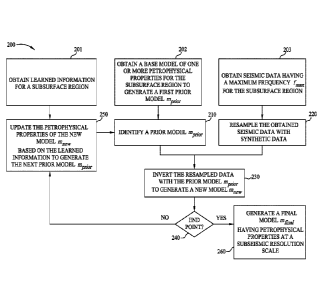
updated prior oiodol.
372 which is based on new model 381 and learned information for the subsurface
region. For
23 .. example, the learned information may be prObability distributions for
different rock types and
transitional probabilities. In FIG. 3C, the porosity of the prior model in the
shale appears too
large, while the- sand appears -to have a porosity that is too low. .As
illustrated, the porosity and
\Tay 'values of new model 381 of FIG. 3B are used to derive the prior model
372 of FIG. 3C.,
A general framework for updating petrophysical properties based on learned
information can
.3a be found in US Patent Application NO, 2018/0156932.
(0054) The method continues at block .210 as before. rOtexample, FIG.
.30 intimates new
model 382 resulting from an inversion using linear physics of the synthesized
seismic data and
the prior model 372. FIG. 3E illustrates an updated prior model 373 which is
based on new
- 16 -
Date Recue/Date Received 2022-07-04
CA 03111394 2021-03-02
WO 2020/055592 PCT/US2019/048599
model 382 and the learned information based on the two rock types present in
the true model
(Table 1) as well as two artificial lower quality sands. In the illustrated
example of FIG. 3E,
two porosity values (0.17 and 0.28) are determined for the shale and the sand,
respectively.
[0055] FIG. 3G shows the prior model 374, which was determined from the
parameter
estimate 383 using only two rock types (Table 1). The shale background appears
to be predicted
correctly, and the prior model appears almost identical to the true model.
FIG. 3H shows the
inversion result with the updated prior model 384, using the prior model 374
and nonlinear
physics.
[0056] The method 200 concludes at block 260, wherein the output is a
final model (or
to final updated model) of petrophysical properties at a sub-seismic
resolution scale. For example,
FIG. 3J illustrates a final model 385 which is very close to "true" porosity
model 370. It should
be appreciated that final model 385 is not as sharp as the prior model 375 (in
FIG. 31) at least
in part because model smoothing was used for regularization. Other
regularization terms could
be used to better maintain the frequency in the prior model, e.g. any LIE
based regularization or
is smoothing the difference between the prior model and the petrophysical
property estimate from
the optimization step.
[0057] In some embodiments, the prior model is learning the sub-seismic
information from
the petrophysical property estimates iteratively. In some embodiments, the
inversion may be
run using a finer sampling than typically used for seismic data to allow for
inclusion of sub-
20 seismic information as well as more accurate placement of boundaries. In
some embodiments,
the inversion results in estimates for porosity and Vday. These estimates may
then be used in a
learning step to infer a new prior model, which is consistent with the
porosity and Vciay
estimates. In some embodiments, the learning step may be done with any type of
machine
learning, ranging from a simple ID Hidden Markov Model to some deep learning
trained on
25 3D concept models. In some embodiments, the sampling rate at which the
inversion is run
(during the optimization step) and at which the prior model is inferred
(during the learning
step) is fine enough to allow learning sub-seismic information. During
subsequent iterations,
the inversion may be run using the learned prior model, which contains sub-
seismic
information.
30 [0058] In some embodiments only nonlinear physics is used instead
of a two-step approach
of (1) linear for the first n iterations followed by (2) nonlinear for all
iterations subsequent to
the first through nth iterations (i.e., (1) linear for the first one or more
iterations, followed by
(2) non-linear for all iterations subsequent to the first one or more
iterations). In some
embodiments only linear physics is used for all iterations without any
subsequent inversion
- 17 -
using nonlinear physics. In some embodiments nonlinear physics is used to
predict the seismic
amplitudes, and the rock physics model is linear. In some embodiments linear
physics is used
to Predict the seismic amplitudes, and the rock physics model .is nonlinear.
In some
embodiments, different combinations of geophysical data and/or geophysical
properties are
used.
[0059] In some embodiments, resampling may be applied as shown at block
220 and/or
before or during the iterations of the inversion process of block 230, For
example, instead of
resampling the data before the inversion as illustrated in FIG. 2, the
resampling might be done
on-the fly. For example, in one or more iterations, the data to be inverted
may be sampled at a
io first frequency (e.g 4 ms) and may be resamplod into memory at a second
frequency (e.g., 2
ms) as the inversion is performed. As another example, separate data grids may
be used for the
inversion and the forward modeling. In this example, resampling may transform
the data from
a coarse modeling grid to a line inversion grid. A more detailed description
of the inversion
and forward modeling on different grids is described in U.S. Patent No.
8,923,094.
is In at least some portions of U.S. Patent No. 8,923,094,
the inversion happens at the seismic scale, and only the forward
models for non-seismic data (e.g. electromagnetic data) are on a coarser grid.
In some
embodiments disclosed herein, the scaling between fine and coarse grids may
apply to non-
seismic data and seismic data, and the inversion grid may be defined at a
finer sampling than
2o the modeling grid. In some embodiments, the prior model may be defmed at
a grid finer than
standard seismic sampling, thus allowing to resample with high frequency
information during
the inversion,
10060] FIGs. 4A-4E show the first derivative of the inverted porosity
for the synthetic
wedge model corresponding to the iterations shown in FIGs. 3A, 3C, 3E, 3G, and
31. As shown
2.5 in FIG. 4A, the first iteration has a fairly smooth derivative at the
edge of the wedge.
Subsequent iterations, shown in FIGs. 4B-4E, each using an updated prior
model, show much
sharper derivatives. FIG. 4F shows the spectral content (e.g., first
derivative) of the
porophysical property estimates shown in FIGs, 4A-4E. Since the porosity in
FIG. 3A is a
single value throughout the subsurface region, FIG. 4A contains no sub-seismic
frequencies.
30 The spectrum 410, corresponding to FIG. 4A, drops at around 50 Hz and
does not extend to
high frequencies (e=g, in this case, frequencies above about 77 Hz), That is,
after the first
optimization step in block 230, the solution basically contains frequencies in
the seismic
frequency band. After the first learning step in block 250, the solution
sharpens and contains
sub-seismic frequencies, as illustrated by spectra 420, 430, 440, 450 in FIG.
4F, corresponding
- 18 -
Date Recue/Date Received 2022-07-04
CA 03111394 2021-03-02
WO 2020/055592 PCT/US2019/048599
to FIGs. 4B-4E, respectively. It can be seen that, once the prior model is
learned, the boundary
estimate gets sharper, and the solution extends into the sub-seismic frequency
range.
100611 In some embodiments, additional regularization may be utilized,
especially for
nonlinear problems. All examples shown here are run with simple, first
derivative-based
vertical smoothing of the petrophysical property estimate, as discussed
earlier. However, other
regularization might be more suitable.
[0062] For example, a regularization that is particularly well suited if
using a prior model
with sharp boundaries is to smooth the difference between the prior model and
the
petrophysical properties estimate from the current iteration. This type of
regularization may
io better retain sharp boundaries in the prior model because the boundaries
are not penalized.
[0063] As another example discussed earlier, any Li-norm based
regularization may be
utilized so as to better retain single outliers (e.g., a sharp jump in the
petrophysical property
estimate).
[0064] A prior model may help recover information missing or
underrepresented in high
is frequency ranges (e.g., information about signals attenuated through
mechanical loss and/or
wavefield scattering). For example, the model structure at each iteration may
be informed by a
prior model. The initial or base values for the model parameters may utilize
the same values as
in the initial prior model. Moreover, the model structure may be configured to
receive
resampled data. At each iteration, the petrophysical properties may be updated
based on both
20 the resampled data and the prior model. The seismic inversion adds the
sub-seismic information
from the prior model into the new model. At each iteration, the weighting
between the
resampled seismic data and prior model may be adjusted so that the prior model
is consistent
with the data. Moreover, a combination of the finer sampling of the resampled
seismic data and
the learning step being able to infer sub-seismic prior models allows the
optimization step to
25 return petrophysical property estimates with frequency content beyond
the seismic scale. The
petrophysical property estimates in the seismic frequency band are driven by
the seismic data,
while the petrophysical property estimates at sub-seismic resolution scales
may be driven by
the learned information. The finer sampling may also allow more precise
estimates of layer
thickness as well as recovering thin sands.
30 [0065] In practical applications, the present technological
advancement must be used in
conjunction with a seismic data analysis system (e.g., a high-speed computer)
programmed in
accordance with the disclosures herein (including, e.g., for performing
inversion, resampling,
and/or generating any of the various models (e.g., models of the subsurface)
as described
herein). Such a seismic data analysis system may be referred to in generic
shorthand simply as
- 19 -
CA 03111394 2021-03-02
WO 2020/055592 PCT/US2019/048599
a "computer" or "computer system." The same or a different computer (and/or
seismic data
analysis system) may be used to carry out different inversions, and/or
different steps of
generating models, and/or other activities such as resampling. Thus, referring
to any of these
steps as carried out "using a computer" will be understood to mean that the
same or different
computers may be used for such steps, unless context clearly dictates
otherwise.
[0066] Preferably, in order to efficiently perform FWI, the seismic data
analysis system is
a high performance computer ("HPC"), as known to those skilled in the art.
Such high
performance computers typically involve clusters of nodes, each node having
multiple CPUs
(which can be understood also to include processor functionality on hardware
such as graphics
processing units or GPUs), and computer memory that allow parallel
computation. The models
may be visualized and edited using any interactive visualization programs and
associated
hardware, such as monitors and projectors. The architecture of the system may
vary and may
be composed of any number of suitable hardware structures capable of executing
logical
operations and displaying the output according to the present technological
advancement.
is Those of ordinary skill in the art are aware of suitable supercomputers
available from Cray or
IBM, as well as other architectures such as HPCs with multiple GPU clusters.
[0067] FIG. 5 illustrates a block diagram of a seismic data analysis
system 9900 upon
which the present technological advancement may be embodied. A central
processing unit
(CPU) 9902 is coupled to system bus 9904. The CPU 9902 may be any general-
purpose CPU,
zo although other types of architectures of CPU 9902 (or other components
of exemplary system
9900) may be used as long as CPU 9902 (and other components of system 9900)
supports the
operations as described herein. Those of ordinary skill in the art will
appreciate that, while only
a single CPU 9902 is shown in FIG. 5, additional CPUs may be present.
Moreover, the system
9900 may comprise a networked, multi-processor computer system that may
include a hybrid
25 parallel CPU/GPU system. The CPU 9902 may execute the various logical
instructions
according to various teachings disclosed herein. For example, the CPU 9902 may
execute
machine-level instructions for performing processing according to the
operational flow
described.
[0068] The seismic data analysis system 9900 may also include computer
components such
30 as non-transitory, computer-readable media. Examples of computer-
readable media include a
random access memory ("RAM") 9906, which may be SRAM, DRAM, SDRAM, or the
like.
The system 9900 may also include additional non-transitory, computer -readable
media such
as a read-only memory ("ROM") 9908, which may be PROM, EPROM, EEPROM, or the
like.
RAM 9906 and ROM 9908 hold user and system data and programs, as is known in
the art.
- 20 -
CA 03111394 2021-03-02
WO 2020/055592 PCT/US2019/048599
The system 9900 may also include an input/output (I/O) adapter 9910, a
communications
adapter 9922, a user interface adapter 9924, and a display adapter 9918; it
may potentially also
include one or more graphics processor units (GPUs) 9914, and one or more
display driver(s)
9916.
[0069] The I/O adapter 9910 may connect additional non-transitory, computer-
readable
media such as a storage device(s) 9912, including, for example, a hard drive,
a compact disc
("CD") drive, a floppy disk drive, a tape drive, and the like to seismic data
analysis system
9900. The storage device(s) may be used when RAM 9906 is insufficient for the
memory
requirements associated with storing data for operations of the present
techniques. The data
to storage of the system 9900 may be used for storing information and/or
other data used or
generated as disclosed herein. For example, storage device(s) 9912 may be used
to store
configuration information or additional plug-ins in accordance with the
present techniques.
Further, user interface adapter 9924 couples user input devices, such as a
keyboard 9928, a
pointing device 9926 and/or output devices to the system 9900. The display
adapter 9918 is
is driven by the CPU 9902 to control the display on a display device 9920
to, for example, present
information to the user. For instance, the display device may be configured to
display visual or
graphical representations of any or all of the models discussed herein (e.g.,
prior models, new
models, geologic models, rock physics models). As the models themselves are
representations
of geophysical data, such a display device may also be said more generically
to be configured
zo to display graphical representations of a geophysical data set, which
geophysical data set may
include the models (e.g., prior models, new models, updated prior models,
final updated
models, geologic models, rock physics models) described herein, as well as any
other
geophysical data set those skilled in the art will recognize and appreciate
with the benefit of
this disclosure.
25 [0070] The architecture of seismic data analysis system 9900 may be
varied as desired. For
example, any suitable processor-based device may be used, including without
limitation
personal computers, laptop computers, computer workstations, and multi-
processor servers.
Moreover, the present technological advancement may be implemented on
application specific
integrated circuits ("ASICs") or very large scale integrated ("VLSI")
circuits. In fact, persons
30 of ordinary skill in the art may use any number of suitable hardware
structures capable of
executing logical operations according to the present technological
advancement. The term
"processing circuit" encompasses a hardware processor (such as those found in
the hardware
devices noted above), ASICs, and VLSI circuits. Input data to the system 9900
may include
- 21 -
CA 03111394 2021-03-02
WO 2020/055592 PCT/US2019/048599
various plug-ins and library files. Input data may additionally include
configuration
information.
100711 The above-described techniques, and/or systems implementing such
techniques,
can further include hydrocarbon management based at least in part upon the
above techniques.
For instance, methods according to various embodiments may include managing
hydrocarbons
based at least in part upon models constructed according to the above-
described methods. In
particular, such methods may include drilling a well, and/or causing a well to
be drilled, based
at least in part upon the models (e.g., such that the well is located based at
least in part upon a
location determined from the models, which location may optionally be informed
by other
11.) inputs, data, and/or analyses, as well) and further prospecting for
and/or producing
hydrocarbons using the well.
100721 The foregoing description is directed to particular example
embodiments of the
present technological advancement. It will be apparent, however, to one
skilled in the art, that
many modifications and variations to the embodiments described herein are
possible. All such
is modifications and variations are intended to be within the scope of the
present disclosure, as
defined in the appended claims.
- 22 -