Note: Descriptions are shown in the official language in which they were submitted.
CA 03112366 2021-03-09
WO 2021/030298 PCT/US2020/045676
SYSTEMS AND METHODS FOR SECURELY SHARING DATA SETS WITH ADJACENT
ENTITIES
CROSS-REFERENCE TO RELATED APPLICATIONS
[0001] This application claims priority to U.S. Application No.
62/884,752 filed August
9,2020 and titled "SYSTEMS AND METHODS FOR SECURELY SHARING PERMIT OR
INSPECTION RESULTS WITH ADJACENT MUNICIPALITIES." U.S. Application No.
62/884,752 is hereby fully incorporated by reference as if set forth fully
herein.
FIELD
[0002] The present invention relates generally to data sets. More
particularly, the present
invention relates to systems and methods for securely sharing data sets with
adjacent entities.
BACKGROUND
[0003] Known systems and methods for storing and accessing permit and
inspection
results and submissions related to the permit and inspection results are
stored at a municipality
level and accessed through a manual filing system at a municipality office or
through an online
system dedicated to a single municipality. Accordingly, the permit and
inspection results and the
submissions related to the permit and inspection results are effectively
restricted to employees or
public servants of the single municipality. For example, when attempting to
access a building
report or inspection information for a structure located in Municipality 1, an
individual, even if a
civil servant from Municipality 2 and even if Municipality 2 is adjacent to
Municipality 1, must
manually request that data, for example, via email, fax, or mail, or
physically travel to and visit
the municipality office of Municipality 1 where the data is stored.
1
CA 03112366 2021-03-09
WO 2021/030298 PCT/US2020/045676
[0004] In view of the above, there is a continuing, ongoing need for
improved systems
and methods.
BRIEF DESCRIPTION OF THE DRAWINGS
[0005] FIG. 1 is a block diagram of a system in accordance with disclosed
embodiments;
[0006] FIG. 2A is a map of adjacent municipalities in accordance with
disclosed
embodiments; and
[0007] FIG. 2B is a map of adjacent municipalities in accordance with
disclosed
embodiments.
DETAILED DESCRIPTION
[0008] While this invention is susceptible of an embodiment in many
different forms,
there are shown in the drawings and will be described herein in detail
specific embodiments
thereof with the understanding that the present disclosure is to be considered
as an
exemplification of the principles of the invention. It is not intended to
limit the invention to the
specific illustrated embodiments.
[0009] Embodiments disclosed herein can include systems and methods for
securely
sharing data sets with adjacent entities. It is to be understood that the data
sets disclosed herein
can include any type of data as would be known and desired by one of ordinary
skill in the art
and that the adjacent entities disclosed herein can include any type of entity
as would be known
and desired by one of ordinary skill in the art. For example, in some
embodiments, the adjacent
entities can include adjacent municipalities, and the data sets can include
permit or inspection
results, test data, or any other data defined by a first one of the adjacent
municipalities for
2
CA 03112366 2021-03-09
WO 2021/030298 PCT/US2020/045676
securely sharing with other ones of the adjacent municipalities. Similarly, in
some embodiments,
the adjacent entities can include carrier companies, and the data sets can
include any type of RF
signal data a first one of the carrier companies authorizes an operator of a
base station
transmitting or receiving the RF signal data to share with adjacent ones of
the carrier companies.
[0010] In accordance with disclosed embodiments, systems and methods can
store the
data sets in a database that organizes, stores, and/or cross-references the
data sets with
geographic information for locations related to the data sets, for example,
where the data sets
were collected or where the data sets originated. In embodiments in which the
data sets include
the permit or inspection results and the adjacent entities include the
adjacent municipalities, the
geographic information can include a building address, a property
identification number (PIN), a
GPS location, a GPS index, a building diagram, a height of a building, and/or
a municipality
assignment. In this regard, is to be understood that the data sets can be
related to any of a
plurality of buildings, structures, or organizations within any of the
municipalities. It is also to
be understood that the database can segregate the data sets by information
type (e.g. electrical
permits and/or drawings, architectural drawings, public safety coverage
reports).
[0011] In accordance with disclosed embodiments, the database can also
store a list of
geographic boundaries between all of the adjacent entities and authorized
users associated with
all of the adjacent entities. For example, in some embodiments, an
administrative user of a first
of the adjacent entities can define in the database a first set of the
authorized users (e.g.
municipal employees) with access to the data sets for the first of the
adjacent entities and a
second set of the authorized users with rights to share access to the data
sets for the first of the
adjacent entities with other ones of the adjacent entities. In these
embodiments, the database can
store lists of the first set of the authorized users and the second set of the
authorized users, and an
3
CA 03112366 2021-03-09
WO 2021/030298 PCT/US2020/045676
associated processor can restrict and allow access to and the rights to share
the data sets for the
first of the adjacent entities based on the first set of the authorized users
and the second set of the
authorized users as defined.
[0012] In some embodiments, the administrative user of the first of the
adjacent entities
can also define in the database a set of the geographic boundaries (e.g. a
polygon) representing a
border with a second of the adjacent entities and a width or depth of distance
from the border for
which the second of the adjacent entities can directly access the data sets
for the first of the
adjacent entities from the database. The database can store the set of the
geographic boundaries
and the width or depth of distance and, and the associated processor can
restrict and allow access
accordingly. For example, in embodiments in which the adjacent entities
include the adjacent
municipalities and the administrative user of a first of the adjacent
municipalities identifies the
width or depth of distance of 0.1 miles from the border between the first of
the adjacent
municipalities and a second of the adjacent municipalities, one of the
authorized users from the
second of the adjacent municipalities can directly access the data sets from
the database for the
locations in the first of the adjacent municipalities within 0.1 miles of the
border between the
first of the adjacent municipalities and the second of the adjacent
municipalities. In this regard,
it is to be understood that the administrative user of the first of the
adjacent municipalities can
define multiple sets of the geographic boundaries (e.g. multiple polygons)
representing multiple
borders with multiple ones of the adjacent municipalities, and in some
embodiments, the
multiple sets of the geographic boundaries and the multiple borders can be
overlapping.
[0013] In some embodiments, the administrative user of the first of the
adjacent entities
can define in the database which of the adjacent entities can directly access
the data sets for the
first of the adjacent entities from the database and/or which of the
authorized users associated
4
CA 03112366 2021-03-09
WO 2021/030298 PCT/US2020/045676
with the adjacent entities can directly access the data sets for the first of
the adjacent entities
from the database. The database can store such definitions, and the associated
processor can
restrict and allow access accordingly.
[0014] In some embodiments, the associated processor can limit a
direction of sharing
information from the database. For example, when a sharer authorizes sharing
sharer
information with a sharee, the associated processor can allow the database to
share the sharer
information with the sharee. However, if a reciprocal relationship has not
been defined, then the
associated processor can prevent the database from sharing sharee information
with the sharer.
That is, the sharee must authorize sharing the sharee information with the
sharer before the
programmable processor will allow the database share the sharee information
with the sharer.
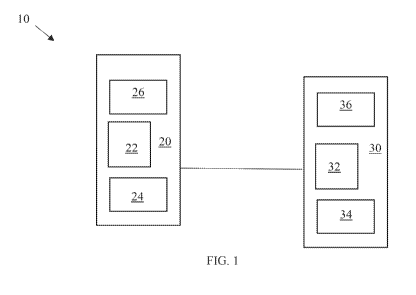
[0015] FIG. 1 is a block diagram of a system 10 in accordance with
disclosed
embodiments. As seen in FIG. 1, the system 10 can include a first server 20
associated with a
first entity and a second server 20 associated with a second entity that is
adjacent to the first
entity. The first server 10 can include a first programmable processor 22, a
first database 24 for
storing first data sets associated with the first entity, and a first
transceiver 26 for communicating
with the second server 30, and the second server 30 can include a second
programmable
processor 32, a second database 34 for storing second data sets associated
with the second entity,
and a second transceiver 36 for communicating with the first server 20.
[0016] A first authorized user associated with the first entity can
provide user input
defining a first geographic boundary between the first entity and the second
entity, and the first
geographic boundary can include a first series of lines identifying a first
border between the first
entity and the second entity. For example, in some embodiments, the user input
defining the first
geographic boundary between the first entity and the second entity can include
one or more of
CA 03112366 2021-03-09
WO 2021/030298 PCT/US2020/045676
the first series of lines drawn on a map of the first and second entities.
Similarly, the first
authorized user can also provide user input defining a first identified
distance from the first
geographic boundary between the first entity and the second entity and into
the first entity that is
authorized for sharing. Then, the first database 24 can store definitions
and/or identifications of
the first geographic boundary between the first entity and the second entity
and the first
identified distance, and the first programmable processor 22 can use those
definitions and/or
identifications to generate a first sharing polygon reaching into the first
entity that is authorized
for sharing and that is defined by the first geographic boundary between the
first entity and the
second entity on one side and a first width therefrom equal to the first
identified distance.
[0017] Additionally or alternatively, the first authorized user can
provide user input
drawing the first sharing polygon, for example, when the first sharing polygon
has a large and/or
irregular shape, and in these embodiments, the first database 24 can store the
first sharing
polygon as drawn.
[0018] In any embodiment, the first programmable processor 22 can use the
first sharing
polygon to restrict or allow access to the first data sets. For example, each
piece of the first data
sets can be associated with a respective piece of geographic information
identifying a respective
location related to that piece of the first data sets. As such, the first
programmable processor 22
can restrict access to each piece of the first data sets associated with the
respective piece of the
geographic information identifying the respective location outside of the
first sharing polygon,
but allow the second server 30 access to each piece of the first data sets
associated with the
respective piece of the geographic information identifying the respective
location inside of the
first sharing polygon.
6
CA 03112366 2021-03-09
WO 2021/030298 PCT/US2020/045676
[0019] Similarly, a second authorized user associated with the second
entity can provide
user input defining a second geographic boundary between the first entity and
the second entity,
and the second geographic boundary can include a second series of lines
identifying a second
border between the first entity and the second entity. For example, in some
embodiments, the
user input defining the second geographic boundary between the first entity
and the second entity
can include one or more of the second series of lines drawn on the map of the
first and second
entities. Similarly, the first authorized user can also provide user input
defining a second
identified distance from the second geographic boundary between the first
entity and the second
entity and into the second entity that is authorized for sharing. Then, the
second database 34 can
store definitions and/or identifications of the second geographic boundary
between the first entity
and the second entity and the second identified distance, and the second
programmable processor
32 can use those definitions and/or identifications to generate a second
sharing polygon reaching
into the second entity that is authorized for sharing and that is defined by
the second geographic
boundary between the first entity and the second entity on one side and a
second width therefrom
equal to the second identified distance.
[0020] Additionally or alternatively, the second authorized user can
provide user input
drawing the second sharing polygon, for example, when the second sharing
polygon has a large
and/or irregular shape, and in these embodiments, the second database 34 can
store the second
sharing polygon as drawn.
[0021] In any embodiment, the second programmable processor 32 can use
the second
sharing polygon to restrict or allow access to the second data sets. For
example, each piece of
the second data sets can be associated with the respective piece of the
geographic information
identifying the respective location related to that piece of the second data
sets. As such, the
7
CA 03112366 2021-03-09
WO 2021/030298 PCT/US2020/045676
second programmable processor 32 can restrict access to each piece of the
second data sets
associated with the respective piece of the geographic information identifying
the respective
location outside of the second sharing polygon, but allow the first server 20
access to each piece
of the second data sets associated with the respective piece of the geographic
information
identifying the respective location inside of the second sharing polygon.
[0022] In accordance with the above, an ability to share the first data
sets and the second
data sets is optimized by applying rights to an intersection of location data
instead of applying
rights to individual locations. For example, the first programmable processor
22 can allow
access to each piece of the first data sets based on an intersection of the
respective piece of the
geographic information with the first sharing polygon, and the second
programmable processor
32 can allow access to each piece of the second data sets based on an
intersection of the
respective piece of the geographic information with the second sharing
polygon. As such, in
embodiments in which the adjacent entities include the adjacent
municipalities, if a first building
in a first of the adjacent municipalities (the first entity) encroaches into
the first sharing polygon,
then the first programmable processor 22 can allow access to all pieces of the
first data sets
associated with the first building. Similarly, if a second building in a
second of the adjacent
municipalities (the second entity) encroaches into the second sharing polygon,
then the second
programmable processor 32 can allow access to all pieces of the second data
sets associated with
the second building.
[0023] Advantageously, identifying and storing the first sharing polygon
and the second
sharing polygons at an entity level as described above can minimize efforts
that would otherwise
be required to construct a list of users authorized to access the first data
sets and the second data
sets, thereby eliminating several calculation steps. Instead, systems and
methods disclosed
8
CA 03112366 2021-03-09
WO 2021/030298 PCT/US2020/045676
herein can simply identify the respective piece of the geographic information
associated with
each piece of the first data sets and the second data sets that intersects
with the first sharing
polygon or the second sharing polygon and allow access to those pieces of the
first data sets and
the second data sets.
[0024] Although not shown in FIG. 1, it is to be understood that the
system 10 can also
include a global server associated with the first entity and the second entity
that includes a global
programmable processor, a global database for storing some or all of the above-
identified
information stored by the first database 24 and the second database 34, and a
global transceiver
for communicating with the first server 20 and the second server 30. In some
embodiments, the
global database can store all of the first data sets, all of the second data
sets, and identifications
of the first sharing polygon and the second sharing polygon received from the
first server 20 and
the second server 30, and in these embodiments, the global programmable
processor can use the
first sharing polygon to restrict or allow access to the first data sets as
described above and use
the second sharing polygon to restrict or allow access to the second data sets
as described above.
However, in some embodiments, the global database can store only those pieces
of the first data
sets associated with the respective piece of the geographic information
identifying the respective
location inside of the first sharing polygon that is shared thereto by the
first server 20 and only
those pieces of the second data sets associated with the respective piece of
the geographic
information identifying the respective location inside of the second sharing
polygon shared
thereto by the second server 30, and in these embodiments, the global
programmable processor
can allow access to any pieces of the first data sets and any pieces of the
second data sets stored
in the global database because a determination as to restricting or allowing
such access will have
already been made by the first server 20 or the second server 30.
9
CA 03112366 2021-03-09
WO 2021/030298 PCT/US2020/045676
[0025] A specific, but non-limiting example of systems and methods
disclosed herein in
which the adjacent entities include the adjacent municipalities can be
illustrated with the maps
seen in FIG. 2A and FIG. 2B.
[0026] As seen in FIG. 2A, in some embodiments, some user associated with
Municipality 2 M2 can provide user input defining a geographic boundary
between Municipality
2 M2 and Municipality 1 Ml, including a series of lines Bl, B2, B3 identifying
a border between
Municipality 2 M2 and Municipality 1 Ml, and identifying an distance W1 from
the geographic
boundary between Municipality 2 M2 and Municipality 1 M1 and into Municipality
M2 that is
authorized for sharing, thereby defining a first sharing polygon SW1 reaching
into Municipality
2 M2 that is authorized for sharing with Municipality 1 Ml. That user
associated with
Municipality 2 M2 can also provide user input defining a geographic boundary
between
Municipality 2 M2 and Municipality 3 M3, including a series of lines B4, B5
identifying a
border between Municipality 2 M2 and Municipality 3 M3, and identifying a
distance W2 from
the geographic boundary between Municipality 2 M2 and Municipality 3 M3 and
into
Municipality 2 M2 that is authorized for sharing, thereby defining a second
sharing polygon
SW2 reaching into Municipality 2 M2 that is authorized for sharing with
Municipality 3 M3.
[0027] However, as seen in FIG. 2B, in some embodiments, some user
associated with
Municipality 2 M2 can provide user input drawing the first sharing polygon SW1
reaching into
Municipality 2 M2 that is authorized for sharing with Municipality 1 Ml. That
user associated
with Municipality 2 M2 can also provide user input drawing a second sharing
polygon SW2
reaching into Municipality 2 M2 that is authorized for sharing with
Municipality 3 M3.
[0028] As seen in both FIG. 2A and FIG. 2B, in some embodiments, a
portion of the first
sharing polygon SW1 can overlap with a portion of the second sharing polygon
SW2, thereby
CA 03112366 2021-03-09
WO 2021/030298 PCT/US2020/045676
defining a third sharing polygon SWB reaching into the Municipality 2 M2 that
is authorized for
sharing with both Municipality MI and Municipality 3 M3.
[0029] Although a few embodiments have been described in detail above,
other
modifications are possible. For example, other components may be added to or
removed from
the described systems, and other embodiments may be within the scope of the
invention.
[0030] From the foregoing, it will be observed that numerous variations
and
modifications may be effected without departing from the spirit and scope of
the invention. It is
to be understood that no limitation with respect to the specific system or
method described herein
is intended or should be inferred. It is, of course, intended to cover all
such modifications as fall
within the spirit and scope of the invention.
11