Note: Descriptions are shown in the official language in which they were submitted.
CA 03115757 2021-04-08
WO 2020/076510
PCT/US2019/053163
LOCALIZED DATA MAPPING FOR INDOOR AND OUTDOOR
APPLICATIONS
CROSS REFERENCE TO RELATED APPLICATIONS
[0001] This
application claims the priority filing benefit of U.S. Provisional Patent
Application Serial No. 62/744,174 filed October 11, 2018, the entirety of
which is
incorporated herein by reference.
FIELD OF THE INVENTION
[0002] The
disclosed systems and methods are generally directed to data mapping for
various indoor and outdoor applications. The disclosed system and method
relates to
generating a localized data map, and more specifically, the disclosed system
and method
relates to a localized turf grass data map used to identify localized
characteristics of areas
of turf grass for the maintenance of athletic fields, sports fields and other
grass covered
areas.
BACKGROUND OF THE INVENTION
[0003] Sports
and athletic field grasses must have dense, thick sod to be able to
withstand impact, and to have the ability to recover quickly. These natural
grass fields
are maintained at the highest level to keep productivity at its best.
Fertilization, irrigation
and mowing are performed on a scheduled basis. Conventionally, the maintenance
of
athletic field turf grass is provided by turf maintenance crews in order to
encourage grass
growth during recovery periods. However, this process is time consuming and
can
produce uneven results where some areas of the grass covered field receive
more or less
treatment or attention than necessary, or may produce inaccurate results due
to human
error.
[0004] A field
of turf grass does not generally grow, or recover from damage, at a
uniform rate, and typically includes areas that grow faster/slower than other
areas due to
a number of factors including microclimates, e.g. amount of sunlight, shade,
moisture,
etc., or include areas of different turf qualities or conditions. For example,
growth and
1
CA 03115757 2021-04-08
WO 2020/076510
PCT/US2019/053163
recovery of the grass is delayed in areas that remain in the shade for long
periods of time,
and growth can be accelerated in areas exposed to more sunlight.
BRIEF SUMMARY OF THE INVENTION
[0005] Generally described hereinafter is a system and method for
generating a
localized turf grass data map. According to one aspect of the present system
and method,
the method comprises (a) traversing an area of turf grass with an outdoor
power
equipment machine, the outdoor power equipment machine including at least one
sensor,
wherein the sensor is configured to receive data; (b) collecting turf grass
data utilizing the
sensor; and (c) communicating the turf grass data to generate a localized turf
grass data
map.
[0006] In an embodiment, the step of traversing an area and the step of
collecting turf
grass data are simultaneous. In an embodiment, the turf grass data is
associated with a
measurement of at least one of (i) resistance, (ii) load, (iii) axle torque,
or a combination
thereof In other embodiments, the turf grass data is associated with a
measurement of at
least one of (i) light, (ii) moisture content, (iii) temperature, (iv) weed
presence, (v) grain,
or (vi) soil compaction.
[0007] In an embodiment, the turf grass data is obtained by a sensor
operatively
connected to a mower blade associated with the outdoor power equipment
machine. In
other embodiments, the turf grass data is obtained by a sensor operatively
connected to an
axle of the outdoor power equipment machine. In other embodiments, the turf
grass data
is obtained by a sensor operatively connected to a motor associated with the
outdoor
power equipment machine.
[0008] In an embodiment, the step of communicating data is concurrent with
or
subsequent to the step of collecting turf grass data.
[0009] In an embodiment, the turf grass data map characterizes areas of
high turf
grass density and low turf grass density. In other embodiments, the turf grass
data map is
used to determine at least one turf grass demand, and wherein the turf grass
demand
comprises irrigation, fertilization, aeration, light, weed control, weed
removal, grooming,
brushing, or a combination thereof
2
CA 03115757 2021-04-08
WO 2020/076510
PCT/US2019/053163
[0010] According to yet another aspect of the disclosed system and method,
a non-
transitory machine-readable medium comprising instructions stored therein,
which when
executed by a machine causes the machine to perform operations, is provided.
The non-
transitory machine-readable medium comprises (a) receiving location data
associated
with an area of turf grass; (b) receiving turf grass data obtained from
traversing the area
of turf grass with a mower; (c) aligning the location data with the turf grass
data; and (d)
generating a localized turf grass data map based on the location data and the
turf grass
data, wherein the turf grass data map characterizes turf grass.
[0011] In an embodiment, the location data is obtained by traversing the
area of turf
grass with a mower. In other embodiments, the location data is derived based
on a map of
the work area, a planned travel route, and a pre-determined mower travel
speed.
[0012] In an embodiment, the turf grass data provides turf grass
characteristics within
the area traversed by the mower. In other embodiments, the location data
provides
location information associated with the area traversed by the mower.
[0013] In an embodiment, the localized turf grass data map characterizes
areas of
high turf grass density and low turf grass density. In other embodiments, the
localized
turf grass data map is used to determine turf grass demands, such as
irrigation,
fertilization, aeration, light, weed control, weed removal, grooming,
brushing, or a
combination thereof
[0014] According to yet another aspect of the disclosed system and method,
a method
for determining placement of a moveable lighting apparatus is provided. The
method
comprising: (a) receiving mapping data at a computing device; (b) creating a
light
exposure map based on the mapping data; and (c) advancing a moveable lighting
apparatus to a desired area.
[0015] In an embodiment, the step of receiving mapping data and the step of
creating
a light exposure map are contemporaneous. In an embodiment, the light exposure
map
depicts areas of high turf grass density and low turf grass density at
specified locations in
a work area. In an embodiment, the method comprises determining a placement of
the
moveable lighting apparatus based on the light exposure map.
3
CA 03115757 2021-04-08
WO 2020/076510
PCT/US2019/053163
[0016] In an
embodiment, the step of advancing the moveable lighting apparatus is
automated, manual or is accomplished via remote control. In an embodiment, the
desired
area comprises at least one area of low turf grass density.
[0017]
According to yet another aspect of the disclosed system and method, an
outdoor power equipment machine for producing a localized turf grass data map
is
provided. The outdoor power equipment machine comprising: a motor operatively
connected to the outdoor power equipment machine; at least one sensor
configured to
obtain turf grass data and location data from a work area or other operating
environment;
a data storage system, including a storage medium to maintain the turf grass
data and the
location data; and a communication system for communicating the turf grass
data and the
location data used to produce a localized turf grass data map.
[0018] In an
embodiment, the outdoor power equipment machine further comprises at
least one sensor operatively connected to the mowing blade. In an embodiment,
the
outdoor power equipment machine provides irrigation, fertilization, aeration,
weed
control, weed removal, grooming, brushing, or a combination thereof
[0019]
According to yet another aspect of the disclosed system and method, a device
is provided. The device comprising: a processor; and a computer readable
medium,
configured to store instructions, that when executed by the processor, cause
the device to
perform functions comprising: receiving sensor data collected by one or more
sensors of
an outdoor power equipment machine indicative of turf grass data in an area
traversed by
the mower; receiving sensor data collected by one or more sensors of the
outdoor power
equipment machine indicative of a history of geographic locations within the
area
traversed by the outdoor power equipment machine; aligning at least a portion
of the turf
grass sensor data with the historical geographic location sensor data; and
generating a
localized turf grass data map.
[0020] In an
embodiment, the function of aligning at least a portion of the turf grass
sensor data with the historical geographic location sensor data comprises
synchronizing
the turf grass sensor data with the historical geographic location sensor data
to localize
the turf grass sensor data to a location of the outdoor power equipment
machine.
[0021]
According to yet another aspect of the disclosed system and method, the
method, comprises: receiving, at a computing system from an outdoor power
equipment
4
CA 03115757 2021-04-08
WO 2020/076510
PCT/US2019/053163
machine, turf grass sensor data indicative of localized turf grass
characteristics in a work
area; storing the turf grass sensor data in a memory associated with the
computing
system; receiving, at a computing system from the outdoor power equipment
machine,
sensor data indicative of a history of geographic locations of the outdoor
power
equipment machine within the work area; storing the historical geographic
location
sensor data in a memory associated with the computing system; accessing, from
the
memory, the turf grass sensor data and the historical geographic location
sensor data;
correlating the turf grass sensor data and the historical geographic location
sensor data to
form aligned sensor data; and generating a localized turf grass data map based
on the
aligned sensor data.
[0022] In an
embodiment, correlating the turf grass sensor data and the historical
geographic location sensor data comprises aligning at least one timestamp
associated
with the turf grass sensor data with at least one timestamp associated with
the historical
geographic location sensor data.
[0023] In an
embodiment, the method comprises: identifying areas of turf grass
requiring treatment within the work area based on the localized turf grass
data map; and
applying a treatment to the areas of turf grass in the work area. In some
embodiments, the
treatment comprises providing an artificial light source, irrigation,
fertilization, aeration,
insect control, weed control, weed removal, grooming, brushing, grass seed, or
a
combination thereof
[0024] In an
embodiment, the method comprises: identifying areas of high turf grass
density within the work area based on the localized turf grass data map; and
scheduling a
mowing operation directed to the areas of high turf grass density in the work
area.
[0025]
According to yet another aspect of the disclosed system and method, a method
for generating a localized data map is provided. The method comprises (a)
traversing an
area with a machine, the machine including at least one sensor, wherein the
sensor is
configured to receive data; (b) collecting data of the area utilizing the
sensor; and (c)
communicating the data to generate a localized data map.
[0026] In some
embodiments, the area is either an indoor or an outdoor area. In some
embodiments, the step of traversing an area and the step of collecting data
are
CA 03115757 2021-04-08
WO 2020/076510
PCT/US2019/053163
simultaneous. In some embodiments, the data is associated with a measurement
of at least
one of (i) resistance, (ii) load, (iii) axle torque, or a combination thereof
[0027] In some
embodiments, the data is obtained by a sensor operatively connected
to an axle of the machine. In some embodiments, the data is obtained by a
sensor
operatively connected to a motor associated with the machine. In some
embodiments, the
step of communicating data is concurrent with or subsequent to the step of
collecting
data. In some embodiments, the data provides characteristics with the area
traversed by
the machine. In some embodiments, the data provides location information
associated
with the area traversed by the machine.
[0028] In some
embodiments, the localized data map characterizes areas of the
presence or absence of an object or a substance. In some embodiments, the
object or the
substance is associated with at least one of (i) plants, (ii) crops, (iii)
ice, (iv) snow, (v)
debris, (vi) carpet, (vii) asphalt, or (viii) other particulates. In some
embodiments, the
localized data map is used to determine indoor or outdoor demands, such as
irrigation,
fertilization, weed control, weed removal, ice removal, snow removal, debris
removal,
dust or gravel removal, or a combination thereof
[0029]
According to yet another aspect of the disclosed system and method, a
machine for producing a localized data map is provided. The machine comprises
a motor
operatively connected to the machine; at least one sensor configured to obtain
data and
location data from a work area or other operating environment; a data storage
system,
including a storage medium to maintain the data and the location data; and a
communication system for communicating the data and the location data used to
produce
a localized data map.
[0030] In yet
another aspect of the present disclosure, a device for generating a
localized data map is provided. The device comprising a processor; and a
computer
readable medium, configured to store instructions, that when executed by the
processor,
cause the device to perform functions comprising: receiving sensor data
collected by one
or more sensors of a machine indicative of data of an area traversed by the
machine;
receiving sensor data collected by one or more sensors of the machine
indicative of a
history of geographic locations within the area traversed by the machine;
aligning at least
6
CA 03115757 2021-04-08
WO 2020/076510
PCT/US2019/053163
a portion of the sensor data with the historical geographic location sensor
data; and
generating a localized data map.
[0031] In some
embodiments, the function of aligning at least a portion of the sensor
data with the historical geographic location sensor data comprises
synchronizing the
sensor data with the historical geographic location sensor data to localize
the sensor data
to a location of the machine.
[0032]
According to yet another aspect of the disclosed system and method, a method
for determining localized characteristics of an area is provided. The method
comprising:
receiving, at a computing system from a machine, sensor data indicative of
localized
characteristics in an outdoor work area; storing the sensor data in a memory
associated
with the computing system; receiving, at a computing system from the machine,
sensor
data indicative of a history of geographic locations of the machine within the
outdoor
work area; storing the historical geographic location sensor data in a memory
associated
with the computing system; accessing, from the memory, the sensor data and the
historical geographic location sensor data; correlating the sensor data and
the historical
geographic location sensor data to form aligned sensor data; and generating a
localized
data map based on the aligned sensor data.
[0033] In some
embodiments, correlating the sensor data and the historical
geographic location sensor data comprises aligning at least one timestamp
associated
with the sensor data with at least one timestamp associated with the
historical geographic
location sensor data
[0034] In an
embodiment, a method includes (a) receiving mapping data at a
computing device, (b) receiving soil compaction level data at a computing
device, (c)
creating a soil compaction level map based on the received mapping data and
the
received soil compaction level data, and (d) performing an aeration operation
based on
the soil compaction level map.
[0035] In an
embodiment, an outdoor power equipment machine for producing a
localized soil compaction data map includes at least one motor operatively
connected to
the outdoor power equipment machine, at least one sensor configured to obtain
turf soil
compaction data and location data from a work area or other operating
environment, a
data storage system, including a storage medium to maintain the turf grass
data and the
7
CA 03115757 2021-04-08
WO 2020/076510
PCT/US2019/053163
location data, and a communication system for communicating the turf grass
data and the
location data used to produce a localized turf grass data map.
BRIEF DESCRIPTION OF SEVERAL VIEWS OF THE DRAWINGS
[0036] These
and other features of the disclosed system and method, and their
advantages, are illustrated specifically in embodiments of the invention now
to be
described, by way of example, with reference to the accompanying diagrammatic
drawings, in which:
[0037] FIG. 1
is a flowchart illustrating an exemplary method in accordance with an
illustrative embodiment of the disclosed system and method;
[0038] FIG. 2
is a flowchart illustrating an exemplary method in accordance with an
illustrative embodiment of the disclosed system and method;
[0039] FIG. 3
is a flowchart illustrating an exemplary method in accordance with an
illustrative embodiment of the disclosed system and method;
[0040] FIG. 4
is a block diagram of an outdoor power equipment machine in
accordance with an illustrative embodiment of the disclosed system and method;
[0041] FIG. 5
is a block diagram of a computing device in accordance with an
illustrative embodiment of the disclosed system and method;
[0042] FIG. 6
is a flowchart illustrating an exemplary method in accordance with an
illustrative embodiment of the disclosed system and method; and
[0043] FIG. 7
is a flowchart illustrating an exemplary method in accordance with an
illustrative embodiment of the disclosed system and method. It should be noted
that all
the drawings are diagrammatic and not drawn to scale. Relative dimensions and
proportions of parts of these figures have been shown exaggerated or reduced
in size for
the sake of clarity and convenience in the drawings. The same reference
numbers are
generally used to refer to corresponding or similar features in the different
embodiments.
Accordingly, the drawings and description are to be regarded as illustrative
in nature and
not as restrictive.
8
CA 03115757 2021-04-08
WO 2020/076510
PCT/US2019/053163
DETAILED DESCRIPTION
[0044] The following terms are used throughout the description, the
definitions of
which are provided herein to assist in understanding various aspects of the
subject
disclosure.
[0045] As used herein the terms "outdoor power equipment machine",
"machine",
"power equipment", and "equipment" are used interchangeably and refer to most
any
type of mowing device, aerator, sprayer, irrigation, pest control, or most any
other type of
machine used to maintain an area of turf. The term "machine" may also include
any
machine, device, or other apparatus used for traversing outdoor spaces such
as, but not
limited to, a parking lot, rooftop, or rooftop garden; or alternatively,
indoor spaces, such
as, but not limited to, the interior of a home, a greenhouse, or other
building structure.
[0046] As used herein the terms "mower" and "mowing device" are used
interchangeably and refer to any of an autonomous mower, reel mower, manual
mower,
walk-behind mower, riding mower, commercial mower, and most any other mowing
machine.
[0047] As used herein, the term "work area" refers to (1) areas of turf
grass that are
grown and maintained, for example, but not limited to, on athletic fields,
sports fields,
lawns, golf courses, baseball fields, football fields, tennis courts, soccer
fields,
recreational sites, roof top gardens, fields, and other similar grass covered
areas, and (2)
any other desired indoor or outdoor region.
[0048] As used herein, the term "turf grass" refers to numerous types and
varieties of
grasses such as those used on lawns, athletic fields, sports fields, and the
work areas
detailed above.
[0049] As used herein, the term "data" refers to and includes such data or
information
as (i) turf grass data, (ii) data collected within a desired indoor space,
and/or (iii) data
collected within a desired outdoor space. As used
herein, the term "turf grass data"
refers to and includes such data or information as (i) grass demands, such as
mowing,
irrigation, fertilization, insect control, light, and combinations thereof,
(ii) turf grass
density, (iii) soil compaction, (iv) moisture content, (v) presence or absence
of insects,
(vi) presence or absence of weeds, (vii) temperature and/or humidity, (viii)
turf grain, and
combinations thereof
9
CA 03115757 2021-04-08
WO 2020/076510
PCT/US2019/053163
[0050] As used
herein, the term "turf grass density" refers to and includes such
characteristics as grass quantity, spatial density, and areas of high or low
grass thickness,
areas of high or low grass height, frequency, or the like. With reference to
FIG. 1, a
flowchart illustrating an exemplary method 100 for generating a localized turf
grass data
map is shown. The method 100 includes (a) traversing an area of turf grass
with a
mowing device (step 102), (b) collecting turf grass data from a sensor (step
104), and (c)
communicating turf grass data to generate a localized turf grass data map
(step 106).
[0051] While,
for purposes of simplicity of explanation, the methodologies illustrated
in FIGS. 1-3 and 6 are shown and described as a series of acts, it is to be
understood and
appreciated that the subject disclosure is not limited by the order of acts,
as some acts
may, in accordance with the disclosure, occur in a different order and/or
concurrently
with other acts from that shown and described herein. For example, those
skilled in the
art will understand and appreciate that a methodology could alternatively be
represented
as a series of interrelated states or events, such as in a state diagram.
Moreover, not all
illustrated acts may be required to implement a methodology in accordance with
the
disclosure.
[0052] In step
102, a mowing device traverses a work area. The mowing device of the
disclosed system and method includes at least one sensor configured to collect
data
indicative of the turf grass in the work area. In some embodiments, in step
102, an
outdoor power equipment machine traverses a work area, wherein the outdoor
power
equipment machine includes at least one sensor configured to collect data
indicative of
the turf grass in the work area.
[0053] In step
104, while traversing the work area, turf grass data is collected by the
sensors. In an embodiment, data is gathered during operation of the outdoor
power
equipment machine, and no separate measures are needed to traverse the work
area apart
from such operation. Thus, in some embodiments, the step of traversing an area
(step
102) and the step of collecting turf grass data (step 104) occur
simultaneously.
[0054] In some
embodiments, the turf grass data is determined by collecting or
measuring (i) resistance, (ii) load, (iii) axle torque associated with the
outdoor power
equipment machine or mowing device, or a combination thereof In some
embodiments,
the turf grass data is obtained by one or more sensors operatively connected
to a mower
CA 03115757 2021-04-08
WO 2020/076510
PCT/US2019/053163
blade of the mowing device. The sensor can be configured to collect data
associated with
a varying amount of resistance at the mower blade during the mowing operation.
In other
embodiments, the turf grass data is collected utilizing a sensor operatively
connected to
an axle associated with the outdoor power equipment machine. The sensor can be
configured to collect data associated with a varying amount of torque at the
axle during
operation. In yet another embodiment, the turf grass data is collected by a
sensor
operatively connected to a motor associated with the outdoor power equipment
machine.
The sensor can be configured to collect data associated with a varying amount
of load on
the motor during operation.
[0055] In some embodiments, the turf grass data is associated with a
measurement of
at least one parameter, including but not limited to, (i) light, (ii) moisture
content, (iii)
temperature or humidity, (iv) presence or absence of weeds, (v) grain, or (vi)
soil
compaction.
[0056] In some embodiments, the sensor can be configured to collect data
associated
with varying amounts of light the turf grass receives at a specific time and
location. In
other embodiments, the sensor can be a humidity gage configured to determine
the
amount of water vapor present at a specific time and/or location of an area of
turf grass.
[0057] In other embodiments, the sensor can be a vision sensor used to view
and
capture either the presence or absence of a weed or weed species. Such vision
sensor
information can be used to identify, locate and remove the weed species. In
some
embodiments, weed identification and removal occur simultaneously. In other
embodiments, areas containing the presence of weeds can be identified and
scheduled to
be removed, either manually or by any other available means.
[0058] In other embodiments, the sensor can be a force sensor or load
sensor
configured to measure soil compaction, indicative of how compact the ground
soil of an
area of turf grass is at a specific time and location. In an embodiment,
sensors associated
with the tines of an aerator are utilized to measure soil compaction, for
example, in
pounds per square inch (PSI).
[0059] Turf grass data can be collected continuously or at pre-determined
intervals
while traversing the work area. The sensor data can be associated with a
timestamp and
stored in memory for later use.
11
CA 03115757 2021-04-08
WO 2020/076510
PCT/US2019/053163
[0060] During
step 106, the turf grass data that has been collected is stored in
memory for later use by a computing device configured to generate a localized
turf grass
data map.
[0061] In some
embodiments, the step of communicating data (step 106) is
concurrent with the step of collecting turf grass data (step 104). In other
embodiments,
the step of communicating data (step 106) is subsequent to the step of
collection turf
grass data (step 104).
[0062] The
localized turf grass data map of the disclosed system and method
characterizes the area of turf grass that has been traversed. In some
embodiments, the
localized turf grass data map characterizes areas of high turf grass density
and low turf
grass density. In some embodiments, the localized turf grass data map can be
used to
determine turf grass demands, such as mowing, irrigation, fertilization,
insect control,
light, and combinations thereof
[0063] In
other embodiments, a localized data map can characterize areas of high soil
compaction and low soil compaction. The localized data map can characterize a
level or
measure of soil compaction at a specific time and location. Soil compaction
has a direct
correlation to the health of the plant. Aeration is a process which involves
perforating the
soil with holes to allow air, water and nutrients to penetrate the soil. The
main reason for
aerating is to alleviate soil compaction. Core aeration is a type of lawn
aeration involving
a machine (a lawn aerator) with hollow tines that mechanically removes plugs
or "cores"
of soil, and thatch from a lawn. Core aeration reduces soil compaction,
creating channels
through which oxygen, water, and nutrients can penetrate into the soil.
[0064] The
more compacted the soil is, the more energy is required to penetrate the
soil during the aeration process. Conventional aerators operate
indiscriminately, that is,
the aerator tines perforate uniformly over any given area of soil, even if
only a small
percentage of the area requires treatment. This is not ideal, since soil
compaction levels
over a turf grass areas are generally not uniform. For example, golf fairways,
and some
sports fields, include central areas which tend to become more compacted,
while the
outlying areas remain less compacted.
[0065] In an
embodiment, an electrically driven punch tine aerator can be utilized to
obtain soil compaction data. Traditional punch tine aerators include crank
shafts having
12
CA 03115757 2021-04-08
WO 2020/076510
PCT/US2019/053163
connecting rods with tines attached at the ends, a force sensor or load sensor
in operable
communication with the individual tines, or a portion of the tines, can be
utilized to
gather associated with soil compaction.
[0066] In an
embodiment, each aerator crank can be driven with a separate motor, the
current draw of each motor can be measured, and the measurement data utilized
to
produce a soil compaction level map, which can then be compared against a
predetermined desired compaction level.
[0067] In
other embodiments, a single large motor driving multiple crank shafts is
utilized, and measurement data associated with the current draw of the motor
is utilized
to produce a soil compaction level map.
[0068] In
further embodiments, soil compaction data can be measured utilizing load
cells attached to some or all of the aerator's mechanically driven crank
shafts.
[0069] It is
time consuming and labor intensive to treat large areas of turf. Mapping
the soil compaction levels for a given sports turf enables subsequent aeration
processes to
be tailored specifically utilizing the collected soil compaction data. A
localized soil
compaction data map can be utilized to a) increase or decrease spacing of the
aeration
operation, increasing the spacing allows the machine to travel faster, b)
increase or
decrease the depth of the aeration operation, decreasing the depth allows the
machine to
travel faster, and/or c) increase or decrease the angle entry of the tine, to
affect the level
of heave, decreasing the angle entry allows the machine to travel faster. This
provides a
more effective method of making the overall compaction levels the same, and
increasing
the uniformity of the playing surface.
[0070] FIG. 2
illustrates a flow diagram of an example method 200 for generating a
localized turf grass data map. The method 200 includes (a) receiving location
data
associated with an area of turf grass (step 202), (b) receiving turf grass
data obtained
from traversing an area of turf grass with an outdoor power equipment machine
(step
204), (c) aligning the location data and the turf grass data (step 206), and
(d) generating a
localized turf grass data map based on the aligned location data and the turf
grass data,
wherein the localized turf grass data map characterizes an area of turf grass
(step 208).
[0071] In step
202, location data, associated with an area of turf grass traversed with
an outdoor power equipment machine, is received at a computing device 500
(e.g., a
13
CA 03115757 2021-04-08
WO 2020/076510
PCT/US2019/053163
client application or server). The location data can be collected as the
machine traverses
the work area. The location data can be associated with a time stamp and
stored in
memory for later use.
[0072] The
location data referred to herein includes location information associated
with the area traversed by the machine. For example, location data can be
obtained from
real-time locating systems (RTLS), global positioning system (GPS), Light
Detection and
Ranging (LIDAR), ultra-wideband radar, beaconing systems, odometer, inertial
measurement unit, velocity meter, acceleration sensors, Global System for
Mobile
Communications (GSM) localization, or most any other systems and sensors.
[0073] In
other embodiments, location data can be generated on demand or can be
pre-determined. For example, the location of the machine within the work area
can be
derived based on a map of the work area, planned travel route, and a
predetermined or
calculated travel speed of the machine. The location data from previous
traversals of the
work area can stored in memory and subsequently accessed. For example, in some
embodiments, location data from previous traversals of the work area can be
stored in a
cloud computing environment and subsequently accessed. Location data from
previous
traversals of the work area can be aggregated and averaged to yield a set of
reference
location data. A calculated timestamp can be added to the pre-determined
location data.
[0074] In step
204, turf grass data obtained from traversing an area of turf grass with
an outdoor power equipment machine is received. In some embodiments, the turf
grass
data provides turf grass characteristics within the area traversed. The turf
grass data can
include, for example, numerous incremental time stamped measurements of a
parameter
or a combination of parameters, as measured by operation of the outdoor power
equipment machine. For example, in some embodiments, the turf grass data
includes
multiple time stamped measurements of load on the mower motor, and/or torque
as
measured, for example, at an axle of the mower. In such an embodiment, sensor
data
associated with resistance, load, and/or torque are combined or averaged to
produce the
turf grass data.
[0075] In step
206, the location data and the turf grass data can be aligned, for
example, by synchronizing of the timestamp information of the location data
and the
timestamp information of the turf grass data.
14
CA 03115757 2021-04-08
WO 2020/076510
PCT/US2019/053163
[0076] In step
208, a localized turf grass data map characterizing the turf grass at
locations throughout the work area is generated based on the aligned sensor
data, i.e. the
aligned location data and turf grass data. In some embodiments, the turf grass
map can
used to determine turf grass demands, such as mowing, irrigation,
fertilization, insect
control, light, or a combination thereof, or characteristics, such as but not
limited to, turf
grass density, soil compaction, moisture content, presence or absence of
insects, presence
or absence of weeds, presence or absence of debris, known obstructions (i.e.
trees,
building/stadium geometry, etc.),
temperature and/or humidity, turf grain, and
combinations thereof
[0077] In an
embodiment, turf grain refers to the nap of the grass, or the grain
direction of the individual grass blades, which can bend slightly in a single
direction.
Most commonly, such grain is associated with continually mowing in one or
limited
directions. In terms of a sports field, grass grain can have a significant
impact on the
playability of the field, for example, a golf putting surfaces or greens,
baseball fields, and
grass tennis courts. Data relating to the grass grain direction for an area of
turf grass can
be utilized to inform turf grass maintenance or grooming activities such as
brushing,
and/or mowing direction for subsequent mowing operations.
[0078] In an
embodiment, the localized turf grass data map is used to inform the
application of treatments or maintenance operations. For example, areas of
high turf
grass density can be scheduled to be mowed more frequently than areas of low
turf grass
density, or treatments such as irrigation, aeration, light, fertilizer, insect
control, and/or
grass seed are applied to areas as indicated by the localized turf grass data
map.
[0079] Now
referring to FIG. 3, a method 300 for determining the placement of a
moveable lighting apparatus is discussed. The method includes (a) receiving
mapping
data (step 302), (b) creating a light exposure map with the mapping data (step
304), (c)
identifying a desired area utilizing the light exposure map (step 306), and
(d) advancing a
moveable lighting apparatus to a desired area (step 308).
[0080] In step
302, mapping data is received by a computing device 500. The
mapping data can include a turf grass density map characterizing the turf
grass density at
locations throughout a work area.
CA 03115757 2021-04-08
WO 2020/076510
PCT/US2019/053163
[0081] In step
304, a light exposure map is generated utilizing the mapping data. The
light exposure map indicates areas of turf grass which require additional
light application
or limited light.
[0082] In step
306, the light exposure map can be used to identify a desired area. For
example, the appropriate placement of a moveable artificial lighting apparatus
or system,
which is also be referred to herein as "grow lights," can be determined. The
artificial light
sources or grow lights can be mounted on movable racks, and used during the
day and
night to stimulate growth of the grass, particularly in slower growth areas.
However, such
lighting systems are expensive, may not cover the entire field at once, and
the amount of
electricity used to power the lights is substantial. These grass lighting
systems can be
manually moved by an operator, who determines their placement from one area to
another simply based on visual estimations and personal observations of the
turf, or can
be automated, based on the information received by the light exposure map. The
light
exposure maps in one embodiment of the disclosed system and method allow for
optimal
placement of the grow lights in an area of turf grass, thereby conserving
resources and
providing superior grass growing results when compared to traditional
practices.
[0083] In some
embodiments, the light exposure map depicts areas of high turf grass
density and low turf grass density. Desired areas for the application of the
artificial light
source can be identified based on the light exposure map. For example, a user
can
determine proper placement of the moveable lighting apparatus. Proper
placement can be
visually determined based on the results and conclusions provided by the light
exposure
map, or can be automatically determined based on threshold values. It should
be
understood that the disclosed light exposure map and method of producing said
light
exposure map can be used in other applications, such as, but not limited to,
depicting
areas of high and low crop densities, as well as being used with roof top
gardens in order
to determine areas of high and low light exposure.
[0084] In some
embodiments, the step of receiving mapping data (step 302) and the
step of creating a light exposure map (step 304) are contemporaneous. In such
embodiments, mapping data is received in real-time and a light exposure map is
created
upon receipt of such mapping data therein.
16
CA 03115757 2021-04-08
WO 2020/076510
PCT/US2019/053163
[0085]
Finally, in step 308, a moveable lighting apparatus can be advanced or moved
to the previously identified desired area. In some embodiments, the desired
area includes
areas of low turf grass density.
[0086]
Additionally, the light exposure map created in step 304 can be utilized to
determine optimal placement from one area to another. This is advantageous
because
known moveable lighting apparatuses and systems are placed simply on visual
estimations and personal observations of the turf grass itself, which is
neither efficient
nor accurate. In some embodiments, the step of advancing the moveable lighting
apparatus is automated, manual, or can be accomplished via remote control.
[0087] Many of
the above-described features and applications are implemented as
software processes that are specified as a set of instructions recorded on a
computer
readable medium. When these instructions are executed by one or more
processing units)
(e.g., one or more processors, cores of processors, or other processing
units), they cause
the processing units to perform the actions indicated in the instructions.
Examples of
computer readable media include, but are not limited to, CD-ROMs, flash
drives, random
access memory (RAM), hard drives, EPROMs, etc. FIG. 4 is a block diagram of a
system
400 in accordance with an illustrative embodiment of the disclosed system. An
outdoor
power equipment machine 402, a mower for example, communicates with a
computing
device 500, utilizing a communication framework 404.
[0088] The
outdoor power equipment machine 402 includes a battery 406, motor 408,
controller 410, data stores 412, sensors 414, and a communication module 416.
[0089] The
battery 406 provides power to the outdoor power equipment machine 402
and its subsystems. The motor 408 can include, for example, an electric
motor(s) or an
internal combustion engine operatively connected to a mower blade (not shown).
The
controller 410 receives power from the battery 406 and can include most any
commercially available or custom microprocessor or micro controller.
[0090] The
data stores 412 comprise a storage system for storing information, for
example, sensor data including location information and turf grass data can be
stored and
retrieved for later use. The data stores 412 can also be used to store
programs local to the
outdoor power equipment machine 402. The data stores 412 can include, for
example,
17
CA 03115757 2021-04-08
WO 2020/076510
PCT/US2019/053163
volatile solid-state memory, non-volatile solid-state memory, a magnetic
storage medium,
removable storage media, cloud computing device, or other suitable storage
means.
[0091] Still
referring to FIG. 4, the sensors 414 can be operatively connected to the
outdoor power equipment machine 402 and can include most any device, hardware
and/or software capable of detecting, measuring, and/or recording a property
associated
with the outdoor power equipment 402 and/or its environment. In an embodiment,
sensors 414 can include sensors for measuring or determining location,
resistance, load or
torque. Sensors 414 can include real-time locating systems (RTLS), beaconing
systems,
odometer, inertial measurement unit, velocity meter, acceleration sensors, and
other
location determination sensors and systems. In an embodiment, sensors 414 can
include
sensors for determining light, soil compaction, moisture content, presence or
absence of
insects, presence or absence of weeds, presence or absence of debris, known
obstructions,
temperature and/or humidity, turf grain or nap, and/or combinations thereof
[0092] The
wired or wireless communication module 416 can include one or more
local wireless interfaces, such as an infrared transceiver and/or an RF
adapter, for
example, a Bluetooth adapter, WLAN adapter, Ultra Wideband (UWB) adapter and
the
like, for establishing communication with a network, an intranet, the
Internet, an
accessory, a mobile device, a computer, or most any other electronic device.
The
communication module 416 transmits and receives information related to the
outdoor
power equipment 402 utilizing communication framework 404.
[0093] The
communication framework 404 that can be employed to facilitate
communications between the outdoor power equipment 404 and the computing
device
500. Communication framework 404 can include wired/wireless connectivity to a
local
area network (LAN) and/or larger networks, e.g., a wide area network (WAN)
which can
connect to a global communications network, e.g., the Internet. Communication
framework 404 can provide communication utilizing, for example, cellular
networks,
Bluetooth , and/or Wi-Fi technology IEEE 802.11(a, b, g, n), infrared, Ultra
Wideband
(UWB), or a wired connection such as a universal serial bus (USB) connection.
[0094] FIG. 5
conceptually illustrates an electronic system with which some
implementations of the subject technology are implemented. Computing system
500 can
be a server, computer, phone, PDA, laptop, or tablet computer with one or more
18
CA 03115757 2021-04-08
WO 2020/076510
PCT/US2019/053163
processors embedded therein or coupled thereto, or most any other sort of
electronic
device. Such an electronic system includes various types of computer readable
media and
interfaces for various other types of computer readable media.
[0095]
Computing system 500 includes a bus 502 which connects the
processor/processing unit(s) 504, system memory and read-only memory (ROM)
506,
computer readable medium 508, also referred to herein as data stores, an input
device
interface 510, an output device interface 512, and a network interface 514.
[0096] In some
embodiments, the processes of the subject disclosure are stored in
memory 506, or the computer readable medium 508. The various memory units 506,
508
include instructions for aligning the location data and the turf grass sensor
data to
produce the aligned sensor data, and to generate a localized turf grass data
map based on
the aligned sensor data. The various memory units 506, 508 can also include
instructions
for creating a light exposure map, identifying a desired area utilizing the
light exposure
map and advancing a lighting apparatus to the desired areas. The processing
units 504
retrieve instructions to execute, and data to process, from the memory units
506, 508, in
order to perform the processes of some implementations.
[0097] The
computer readable medium 508 is configured to store instructions. The
computer readable medium 508, can be implemented as "computer readable
instructions", algorithms and/or modules for execution by the processor 502.
Computer
readable instructions can be provided as program modules, such as functions,
objects,
Application Programming Interfaces (APIs), data structures, and the like, that
perform
particular tasks or implement particular abstract data types.
[0098] The
computing device 500 can receive sensor data collected by the one or
more sensors 414 of the mowing device 402 indicative of turf grass density in
an area
traversed by the outdoor power equipment 402. In embodiments, the device 500
can
receive sensor data collected by one or more sensors 414 of the outdoor power
equipment
402 that is indicative of a history of geographic locations within the work
area traversed
by the outdoor power equipment 402. The computing device 500 can process at
least a
portion of the turf grass sensor data in conjunction with the historical
geographic location
sensor data. In some embodiments, the device 500 can generate and output a
localized
19
CA 03115757 2021-04-08
WO 2020/076510
PCT/US2019/053163
turf grass data map. In some embodiments, the aforementioned functions are
performed
simultaneously or in succession of one another.
[0099] In some
embodiments, the computing device 500 is a cloud computing device
or cloud computing environment. The cloud computing environment includes the
infrastructure, platforms and/or software necessary, in which a user does not
need to
maintain resources on a local computing device. The cloud computing
environment can
communicate with any type of computerized device over any type of network
and/or
network addressable connection (e.g., using a web browser).
[00100] Input devices used with input device interface 510 include, for
example,
keyboards and pointing devices. Output device interfaces 512 enables, for
example, the
display of images generated by the computing device 500. Output devices used
with
output device interface 512 include, for example, printers and display
devices, such as
liquid crystal displays (LCD). Devices such as a touchscreen can function as
both an
input and output device.
[00101] The bus 502 couples the computing device 500 to the communications
network 404 through a network interface 514. The computing device 500 can be a
part of
a network of computers (such as a local area network ("LAN"), a wide area
network
("WAN"), or an Intranet, or a network of networks, such as the Internet.
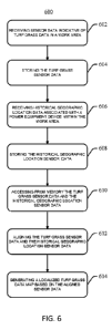
[00102] With reference to FIG. 6, a flowchart illustrating an exemplary method
600
for generating a localized turf grass data map is shown. The method 600
includes
receiving sensor data indicative of turf grass data present at a location in a
work area
(step 602), storing the turf grass sensor data in a memory associated with the
computing
system 500 (step 604), receiving sensor data indicative of a history of
geographic
locations of the outdoor power equipment 402 within the work area (step 606),
storing
the historical geographic location sensor data and the turf grass sensor data
in a memory
associated with the computing system 500 (step 608), accessing the turf grass
sensor data
and the historical geographic location sensor data (step 610), aligning the
turf grass
sensor data and the historical geographic location sensor data to form aligned
sensor data
(step 612), and generating a localized turf grass data map based on the
aligned sensor
data (step 614).
CA 03115757 2021-04-08
WO 2020/076510
PCT/US2019/053163
[00103] In step 602, sensor data indicative of turf grass data present in a
work area is
received at a computing system 500.
[00104] In step 604, the turf grass sensor data is stored in memory associated
with the
computing system 500.
[00105] In step 606, sensor data indicative of a history of geographic
locations of the
outdoor power equipment 402 within the work area is received at a computing
system
500. In some embodiments, the sensor data indicative of a history of
geographic locations
includes periodic automatic measurements of one or more locations of the
outdoor power
equipment 402 within a work area at a given time.
[00106] In step 608, the location data is stored in a memory associated with
the
computing system 500. In some embodiments, the memory referred to in step 608
is the
same as or similar to that mentioned in step 604.
[00107]
Subsequently, in step 610, the turf grass sensor data and the historical
geographic location sensor data are accessed from the memory for use by a
processor 504
of the computing system 500.
[00108] In step
612, the turf grass sensor data and the historical geographic location
sensor data are synchronized to form aligned sensor data. In some embodiments,
the
aligned sensor data includes the combination of the turf grass sensor data,
the historical
geographic location sensor data, and non-mower collected data, such as, but
not limited
to, sun patterns (calendar based), local weather history, local weather
predictions, length
of active play or use on the turf surface, or the like. For example, in some
embodiments,
the aligned sensor data can be used to show sun or light patterns throughout a
calendar
year and be used to predictively determine where shading will most likely
occur
depending on the day or season, which can then be used to proactively
determine turf
grass demands, such as what day/season in the following year will require
lighting,
watering, fertilizing, etc.
[00109] In some embodiments, the function of synchronizing the turf grass
sensor data
and the historical geographic location sensor data includes coordinating at
least one
timestamp associated with the turf grass sensor data with at least one
timestamp
associated with the historical geographic location sensor data.
21
CA 03115757 2021-04-08
WO 2020/076510
PCT/US2019/053163
[00110] A "timestamp" shall be referred to herein as, and will be understood
by one
skilled in the art, the recording of numerous measured data points by a sensor
or multiple
sensors along a series of locations which include an indication of the time
each
measurement was made.
[00111] For example, the turf grass sensor data and historical geographic
location
sensor data can be communicated to a computing device 500. The computing
device 500
is configured to receive the turf grass sensor data and the historical
geographic location
sensor data, synchronize the data (i.e. form aligned sensor data) according to
corresponding timestamps for each data stream. The aligned sensor data can
include a
turf grass measurements or characteristics of turf grass at a defined or
specific location
within the work area.
[00112] In step 614, a localized turf grass data map based on the aligned
sensor data is
generated. From the aligned sensor data, a visual display or image of the data
can be
derived. For example, in some embodiments, the turf grass sensor data can be
overlaid
on the historical geographic location sensor data, such that the relative
positions can be
used to generate the localized turf grass data map, and specific location
characteristics
within the work area, such as areas of high or low turf grass density, or turf
grass
demands, for example, irrigation, aeration, fertilization, light, or a
combination thereof,
may be readily understood. In some embodiments, the turf grass data at various
locations
can be displayed as a dot or point, line, color, or shape, for example, on a
map or an
image of a sports field or other depiction of the work area.
[00113] In some embodiments, step 614 further includes identifying areas of
turf grass
requiring treatment within the work area based on the localized turf grass
data map, and
applying a treatment to the areas of turf grass in the work area. In some
embodiments, the
treatment includes at least one of applying an artificial light source,
irrigation,
fertilization, insect control, and/or grass seed. The localized turf grass
data map can also
be used to determine, visually or otherwise, work areas that require
improvement. For
example, the data map can be used to determine whether or not areas of turf
grass or
other areas are responding to treatments that were previously applied.
[00114] In some embodiments, the step 614 further includes identifying areas
of low
turf grass density within the work area based on the localized turf grass data
map, and
22
CA 03115757 2021-04-08
WO 2020/076510
PCT/US2019/053163
applying a treatment to the areas of low turf grass density in the work area.
In some
embodiments, the treatment includes at least one of applying an artificial
light source,
irrigation, fertilization, insect control, and/or grass seed. In other
embodiments, step 614
further includes identifying areas of high turf grass density within the work
area based on
the turf grass density map, and scheduling a mowing operation for the areas of
high turf
grass density. The mowing operation can include selective mowing such that
areas of
high turf density are mowed and areas of low turf grass density are avoided by
the
mower.
[00115] In some embodiments, the step 614 includes identifying the presence of
a
weed or weed species and applying a treatment to such locations. Such
treatments include
mechanical, biological or chemical methods. In some embodiments, the chemical
methods include treatments applied in spray form, or other like applications.
In other
embodiments, areas containing the presence of weeds can be identified and
scheduled to
be removed, either manually, mechanically, or by any other means available. In
some
embodiments, the mechanical methods can include physical removal of a weed
species
by a tool provided by the outdoor power equipment, or other types of like
equipment or
tools.
[00116] In some embodiments, the step 614 includes identifying levels of soil
compaction for an area of turf grass, and applying a selective treatment to
the turf grass
area. Such treatments can include mechanical, biological or chemical methods.
In some
embodiments, the mechanical methods include an aeration process tailored
specifically
via, for example, collected soil compaction data, and location data to: a)
increase or
decrease spacing of the aeration operation, increasing the spacing allows the
machine to
travel faster, b) increase or decrease the depth of the aeration operation,
decreasing the
depth allows the machine to travel faster, and/or c) increase or decrease the
angle entry of
the tine, to affect the level of heave, decreasing the angle entry allows the
machine to
travel faster.
[00117] With reference to FIG. 7, a flowchart illustrating an exemplary method
700
for generating a localized data map is shown. The method 700 includes (a)
traversing an
area with a machine (step 702), (b) collecting data from a sensor (step 704),
and (c)
communicating data to generate a localized data map (step 706).
23
CA 03115757 2021-04-08
WO 2020/076510
PCT/US2019/053163
[00118] In step 702, a machine traverses a work area. The work area can
include either
an indoor or an outdoor area or space. In some embodiments, the indoor area
can include,
but is not limited to, an interior of a home, commercial building, factory,
warehouse, or
other like facility. In some embodiments, the outdoor area can include, but is
not limited
to, a parking lot, sidewalk, rooftop garden, or other rooftop space.
[00119] In step 704, data is collected from a sensor. The machine of the
disclosed
system includes at least one sensor configured to collect data indicative of
the
characteristics within a specified work area. In some embodiments, the step of
traversing
an area (step 702) and the step of collecting data (step 704) are
simultaneous.
[00120] The data collected is associated with a measurement of at least one of
(i)
resistance, (ii) load, (iii) axle torque, or a combination thereof In some
embodiments, the
data is obtained by a sensor operatively connected to (i) an axle of the
machine, (ii) a
motor of the machine, or (iii) other component associated with the machine
[00121] In some embodiments, in step 704, the machine sensor is configured to
collect
data indicative of the presence or absence of an object or a substance located
within the
work area. In some embodiments, the object or the substance is associated with
at least
one of (i) plants, (ii) crops, (iii) ice, (iv) snow, (v) debris, (vi) carpet,
(vii) asphalt, or
(viii) other particulates.
[00122] In step 706, data collected from the sensor is communicated to the
data to
generate a localized data map. The localized data provides a user with a
visual
representation of a specific parameter or parameters measured within the work
area
traversed.
[00123] In some embodiments, the localized data map is used to determine
indoor or
outdoor demands, such as irrigation, fertilization, weed control, weed
removal, ice
removal, snow removal, debris removal, dust or gravel removal, or a
combination
thereof For example, the localized data map can be used to determine the
location of the
presence of ice, and subsequently be used to apply various deicing methods or
treatments
for removal.
[00124] While embodiments of the disclosed system and method have been
described,
it should be understood that the disclosed system and method are not so
limited and
modifications may be made without departing from the disclosed system and
method.
24
CA 03115757 2021-04-08
WO 2020/076510
PCT/US2019/053163
The scope of the disclosed system and method are defined by the appended
claims, and
all devices, processes, and methods that come within the meaning of the
claims, either
literally or by equivalence, are intended to be embraced therein.