Note: Descriptions are shown in the official language in which they were submitted.
CA 03117308 2021-04-21
WO 2019/084081
PCT/US2018/057207
1
TELECOMMUNICATIONS SYSTEM UTILIZING DRONES
CROSS-REFERENCE TO RELATED APPLICATION
This application claims the benefit of US Provisional Application No.
62/576,885
filed October 25, 2017, which is hereby incorporated by reference.
BACKGROUND
High-speed wireless communication over long distances may be desired in a
number
of industries. The line-of-sight method for propagation is useful for wireless
communication
over a short distance, but over long distances obstructions and the curvature
of the Earth
prevent line-of-sight propagation from being a reliable method of data
transmission. In order
to transmit data to a receiver where line-of-sight propagation is not
available, there are non-
line-of-sight propagation methods that may be used for transmission. These
methods may
is include
skywave propagation, groundwave propagation, or other methods of transmission
to
communicate the data signal. However, these methods may not be able to
transmit data at the
speed desired by a user.
Thus, there is a need for improvement in this field.
CA 03117308 2021-04-21
WO 2019/084081
PCT/US2018/057207
2
SUMMARY
A data communication system provides high-speed wireless communication over
extended distances. With this system, a line of drones are sequentially
launched from a
prevailing upwind location and form a generally straight geodesic line between
the
transmission point and receipt point and vice versa. The winged drones travel
generally along
the geodesic path and are pushed by the prevailing winds towards a landing
location. The
system is designed to maintain spacing between the drones.
At or near the launch site, an uplink is established to transmit data to the
recently-
launched drone. That drone then retransmits via a steerable antenna to the
next drone in the
io line of drones, and the transmission and retransmission continues down
the line of drones
until it reaches at or near a downlink site that receives the transmission. In
one form, a
parabolic array is used for transmissions to and from the ground sites, and a
steerable antenna
is located in the wings of the drones for transmission between the drones.
With this system,
the drones form a virtual conveyor belt of transmission antennas in the sky.
In one form,
is direct line-of-sight transmissions such as microwave transmissions are
used to transmit
between the drones, but other frequencies can be used. The steerable antenna
can include
mechanically and/or electronically steerable antennas.
Conceivably, the drones can be spaced significantly larger distances apart as
they do
not have to deal with the curvature of the Earth. For instance, the drones can
be spaced at
20 around 500 miles apart or can be spaced further or closer together,
depending on
environmental or other requirements. The steerable antennas are also used to
track the
location of the next drone and further help in locating and spacing the drones
apart. This
system helps to transmit large amounts of data rather quickly. Moreover, once
landed, the
drones can be recycled and shipped back to the launch site for further use.
The drones also
25 can incorporate other forms of power such as solar power, and by
following the prevailing
wind patterns can utilize less energy.
While the system will be described with reference to executing financial
trading
strategies, this system and technique can be used in other situations or
industries where time
and/or bandwidth are of concern. For example, this system can be used to
perform remote
30 surgery or medical diagnostics, scientific instruments or studies (e.g.,
for astronomy or
physics), controlling dispersed global computer networks, and/or military
applications. In
another example, the technique can be used for underlying maintenance or
enhancements to
the communication system itself. By way of a non-limiting example, since the
files are
CA 03117308 2021-04-21
WO 2019/084081
PCT/US2018/057207
3
typically large, code for programming and/or reprograming the drones, modems,
antennas,
and/or other system equipment can be sent via the drone and/or along another
high
bandwidth, high latency link, such as a fiber optic cable. Alternatively or
additionally, some
or all of the code can be sent via skywave propagation (e.g., radio) and/or
via line of site
.. transmission, such as via microwaves. The code can include one or more
programs, libraries,
data, and/or subroutines for controlling the equipment depending on various
circumstances.
The resulting changes can be software changes that change the function of the
equipment
and/or physical changes to the equipment, such as to the height and/or angle
of the antenna
system. Later on, depending on the needs at that time, different subroutines,
programs, data,
1() .. and/or areas of the code can be selected. Updates or changes to the
code can be sent
periodically, continuously, or on an as-needed basis.
Further forms, objects, features, aspects, benefits, advantages, and
embodiments of
the present invention will become apparent from a detailed description and
drawings
provided herewith.
CA 03117308 2021-04-21
WO 2019/084081
PCT/US2018/057207
4
BRIEF DESCRIPTION OF THE DRAWINGS
FIG. 1 is a schematic diagram of a system using line-of-sight propagation to
transmit
data.
FIG. 2 is a schematic diagram of a data transmission system.
FIG. 3 is a flowchart showing a method of data transmission using the data
transmission system of FIG. 2.
FIG. 4 is a map showing a communication path for the data transmission system
of
FIG. 2.
FIG. 5 is a schematic diagram of a communication path.
FIG. 6 is a map showing a geodesic path for the communication path of FIG. 2.
FIG. 7 is a map showing a portion of the geodesic path of FIG. 6.
FIG. 8 is a map showing a portion of the geodesic path of FIG. 6.
FIG. 9 is a perspective view of a drone from the data transmission system of
FIG. 2.
FIG. 10 is a perspective view of a shipping configuration of the drone of FIG.
9.
CA 03117308 2021-04-21
WO 2019/084081
PCT/US2018/057207
DESCRIPTION OF THE SELECTED EMBODIMENTS
For the purpose of promoting an understanding of the principles of the
invention,
reference will now be made to the embodiments illustrated in the drawings and
specific
language will be used to describe the same. It will nevertheless be understood
that no
5 limitation of the scope of the invention is thereby intended. Any
alterations and further
modifications in the described embodiments, and any further applications of
the principles of
the invention as described herein are contemplated as would normally occur to
one skilled in
the art to which the invention relates. One embodiment of the invention is
shown in great
detail, although it will be apparent to those skilled in the relevant art that
some features that
itt are not relevant to the present invention may not be shown for the sake
of clarity.
Wireless communication may be used to send data quickly over a long distance.
In
some cases, the transmitter and the receiver may be relatively close, and line-
of-sight
propagation may be used to transmit the desired data. Line-of-sight
propagation sends
electromagnetic waves in a straight line from the transmitter to the receiver.
However, line-
is of-sight transmissions generally cannot travel over the horizon or past
other obstacles.
Therefore, when the receiver is too far away from the transmitter, line-of-
sight propagation
does not work. As illustrated in FIG. 1, a transmitter 104 and a receiver 108
may each be
located on the Earth 112, but may be too far away from each other to use line-
of-sight
propagation to communicate. An electromagnetic wave 116 sent in a straight
line from the
20 transmitter 104 is blocked from reaching receiver 108 due to the
curvature of the Earth 112.
While one location will be described as a "transmitter" station and the other
as a "receiver"
station, the transmitter 104 and receiver 108 locations can be swapped and/or
one or both can
act as a transceiver to facilitate two-way communication.
Skywave propagation is an alternative method to transmit data from transmitter
104 to
25 receiver 108. Skywave propagation uses reflection of a high frequency
electromagnetic wave
off the surface of the Earth 112 and reflection from the ionosphere to bounce
the
electromagnetic waves from the transmitter 104 to the receiver 108. This
process can reliably
transmit data; however changes in the ionosphere and reflection from the Earth
112 have the
potential to cause distortion in the transmitted data signal. Additionally,
adding reflection
30 points increases the distance the data signal travels from the
transmitter 104 to the receiver
108. This added distance can increase latency and delay the receipt of the
data signal at the
receiver 108. As will be explained below, skywave propagation can be used in
conjunction
with the drone-based data transmission system described below.
CA 03117308 2021-04-21
WO 2019/084081
PCT/US2018/057207
6
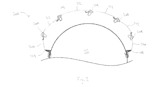
FIG. 2 shows a data transmission system 200 for sending a data signal from the
transmitter 104 to the receiver 108. The data transmission system 200 uses a
line of one or
more drones or unmanned aerial vehicles (UAVs) 204 as relays to transmit the
data signal.
The data signal is sent from a transmitter 104 over a first communication path
208 to a first
drone 204. As an example, the transmitter 104 may be a parabolic array located
at a ground
site that generates a data signal that is to be sent to the receiver 108. The
parabolic array
sends the data signal to the nearest drone 204. The data signal may be
transmitted using any
suitable transmission medium. Because a drone 204 should be relatively close
to the
transmitter 104, a line-of-sight transmission, such as microwave transmission,
may be used to
1() send the data signal from the transmitter 104 to a drone 204. In other
examples, radio waves
may be used to transmit the data signal. In other variations, other types of
communication
paths and techniques are used in conjunction with the drones 204. For
instance, skywave
propagation and/or fiber optic communication channels can transmit data along
at least one
of the legs to, from, and/or between the transmitter 104, receiver 108, and/or
drones 204.
The first drone 204 receives the data signal sent from the transmitter 104
over an
uplink communication path 208 and redirects data signal to the next drone 204
in line over a
drone-to-drone communication path 212. The next drone 204 receives the data
signal and
redirects the data signal over a new drone-to-drone communication path 212 to
the next drone
204 in line. This process continues with each subsequent drone 204 as the data
signal
proceeds toward the last drone 204. The last drone 204 redirects the data
signal over a
downlink communication path 216 where the data signal is received by the
receiver 108. As
noted before, the done-to-drone communication paths 212 can include other
forms of
communication, such as indirect forms like skywave propagation. In some
examples, one or
more of the drones 204 at times can be replaced with a human operated aircraft
that is used to
communicate the data signals.
As the data signal is transmitted, the drones travel in a direction toward the
receiver
108. The drones 204 may be launched from an upwind location so that the drones
204 are
pushed by prevailing winds to reduce the power necessary to move the drones
204. In some
embodiments, the drones 204 may also include a power source that works with
the wind to
move the drone 204 toward the receiver 108. In one example, each drone 204 is
guided
electronically, for example using GPS and/or transponders, and/or may be
guided
mechanically using a gyroscope or another mechanical instrument. The drones
204 in one
form are fully autonomous, but some or all of the drones 204 in other
variations are semi-
CA 03117308 2021-04-21
WO 2019/084081
PCT/US2018/057207
7
autonomous and/or manually controlled by a remote operator. As a drone 204
approaches the
receiver 108, the drone 204 lands and may be returned to the launch location
for reuse. This
process creates a virtual conveyor belt of drones 204 between the transmitter
104 and the
receiver 108. As one drone approaches the receiver 108 and lands, another
drone 204 may be
launched from a position near the transmitter 104 to ensure that the number of
drones 204 in
the air is sufficient to relay the data signal from the transmitter 104 to the
receiver 108. After
a drone 204 has landed, it may be recycled and shipped back to the launch
point, where the
drone 204 may be prepared for reuse.
In some embodiments, the drones 204 may be launched from the same location as
the
1() transmitter 104. However, because the transmitter 104 is able to
transmit a data signal over a
relatively large distance, it is not necessary that the drones 204 be launched
at the same
location as the transmitter. In other embodiments, the drones 204 may be
launched from a
different location close enough to the transmitter 104 to stay within range of
the transmitted
data signal. This can reduce the flight time for each drone 204, saving power
and decreasing
wear and tear on the drone 204. As an example, the transmitter 104 in one form
may have a
range of 500 miles, therefore, a drone 204 can be launched from anywhere
within the 500
miles radius and still be able to receive the data signal from the transmitter
104. Likewise, the
drone 204 may land at the location of the receiver 108, or may land at another
location after
the data signal has been relayed to the receiver 108. In another variation,
the drones 204 are
launched upwind from the transmitter 104 and land downwind from the receiver
108. To
provide redundancy, a group of multiple drones 204 are launched as a swarm
from the same
general area at nearly the same time, and followed by other swarm groups. The
multiple
swarm groups of drones 204 form a mesh network between the transmitter 104 and
receiver
108 so as to provide robust communication network. If one of the drones 204
malfunctions
and/or falls out of range, the other drones 204 still can maintain the
communication link. This
ability of the drones 204 to swarm and form a mesh network can be helpful when
the drones
204 are underpowered (or even unpowered) for the current environmental
conditions (i.e.,
high winds). For instance, the drones 204 can include balloons, dirigible
airships, blimps,
airplanes, helicopters, quadcopters, gliders, and/or other types of aircraft.
The flowchart 300 shown in FIG. 3 describes a method of data transmission as
shown
in the data transmission system 200. A series of drones 204 are launched 305
from a position
so that at least one of the drones is within range of a transmitter 104. The
drones 204 are
spaced apart from each other and directed to follow a transmission path
between the
CA 03117308 2021-04-21
WO 2019/084081
PCT/US2018/057207
8
transmitter 104 and a receiver 108. Once at least the series of drones has
been arranged along
the transmission path, a data signal is transmitted 310 from the transmitter
104 to a drone 204
that is within range of the transmitter 104. The data signal is then relayed
315 between
adjacent drones 204 in the series so that the data signal is sent in the
direction of the receiver
108. In other examples, the data signals can be relayed to non-adjacent drones
204 so as long
as the drones 204 are in close enough range to communicate with one another.
When the data
signal reaches a drone 204 that is within range of the receiver 108, the data
signal is
transmitted 320 from the drone 204 to the receiver 108. In another variation,
multiple drones
204 are scattered and/or are arranged in a swarm along the transmission path
so as to create a
itt mesh network. This mesh network arrangement again provides multiple
communication
paths as well as redundancy so as to make the overall system more robust. It
should be
recognized that communication along the transmission system 200 can be hi-
directional such
that signals can be transmitted from the receiver 108 to the transmitter 104
and vice-versa. In
other words, the data signals can be transmitted in the opposite direction
from which the
is drones 204 fly and/or in the same general direction as the drones 204
travel. Other data, such
as used for modem management and/or requiring different bandwidth (and/or
latency), can
alternatively or additionally be sent along other communication paths like
fiber optic cables,
microwave towers, and/or skywave propagation paths. In further examples, the
drones 204
only cover part of the transmission path, and other communication paths or
systems (e.g.,
20 fiber optic cables, microwave towers, and/or skywave propagation paths)
are used to
complete the communication link.
In some cases, it may be desired for the data signal to be sent from the
transmitter 104
to the receiver 108 as quickly as possible. For example, the data transmission
system 200
may be used by financial trading firms for high-frequency trading, where
trading strategies
25 are carried out on computers to execute trades in fractions of a second.
In high-frequency
trading, a delay of only milliseconds may cost a trader millions of dollars;
therefore, the
speed of transmission of trading instructions is as important as the accuracy
of the data
transmitted. The trading firm and/or third parties may send news, trading
instructions, and/or
other types of data that could assist the trading firm in making trading
decisions from the
30 transmitter 104 to the receiver 108 (and vice-versa) using the data
transmission system 200.
This system 200 and technique can be used in other situations or industries
where latency
and/or bandwidth are of concern. Once more, this system 200 can be for example
used to
perform remote surgery or medical diagnostics, operate scientific instruments
or studies (e.g.,
CA 03117308 2021-04-21
WO 2019/084081
PCT/US2018/057207
9
for astronomy or physics), control dispersed global computer networks, and/or
military
applications. The technique can also be used for underlying maintenance and/or
enhancements to the system 200 itself.
To reduce transmission time, it may be desired that the length of the
transmission path
is reduced so that the drones 204 travel along the shortest possible path from
the transmitter
104 to the receiver 108. When covering long distances, a geodesic line
represents the shortest
route between two points on the Earth's surface. Typically, a geodesic line is
a segment of a
great circle, formed along the intersection of a sphere and a plane passing
through the center
of the sphere. FIG. 4 illustrates a possible route from Chicago to London
along a
itt transmission path that is a geodesic path 404. Often, a geodesic line
appears to be curved
when the geodesic line is projected onto a two-dimensional surface, such as a
map. In the
example shown in FIG. 4, each of the drones 204 travels generally along a
geodesic path 404
following the geodesic line between Chicago and London. The drones 204 can
generally
travel along other geodesic paths 404 along the globe, such as from New York
City to
is London or Seattle to Hong Kong. The timing of the launch of the drones
204 is calculated to
maintain adequate spacing between the drones 204. In some embodiments, the
launch of the
drones may be designed to keep the drones 204 spaced at roughly equal
distances from the
directly preceding and directly trailing drones 204. However, other systems
may have uneven
spacing between the drones 204 traveling along geodesic path 404. In still yet
other
20 examples, the drones 204 have a mesh network type arrangement along the
geodesic path 404
such that the drones 204 are launched in waves and/or on a random basis. The
system 200 in
other examples can have multiple transmitters 104 and/or receivers 108
generally located
along the geodesic or other paths. In this case, the drones 204 can form
multiple
combinations of communication circuits between the transmitters 104 and
receivers 108.
25 As shown in FIG. 5, the drones 204 may not exactly follow the geodesic
path 404
when traveling toward the transmitter 108. Instead, the drones generally
follow the geodesic
path 404 but stay within a band/or zone 504 surrounding the geodesic path 404.
The band
504 can include both horizontal as well as vertical limits. In one form, the
band 504 is narrow
enough to allow the drones 204 within the band 504 to communicate with
adjacent drones
30 204. Factors such as wind speed, wind direction, takeoff location,
storms, and/or landing
location may vary the location of an individual drone 204 from being directly
on the geodesic
path 404. Also, because wind conditions may be different at different
locations along the
geodesic path 404, it is possible that one drone 204 may be on one side of
geodesic path 404
CA 03117308 2021-04-21
WO 2019/084081
PCT/US2018/057207
while an adjacent drone 204 is on the other side of geodesic path 404. The
varying wind
conditions may also vary the heading and/or orientation of adjacent drones
204. The drone
204 in one example can have different yaw, pitch, and/or roll angles. For
example, one drone
204 may be pointed east, while an adjacent drone 204 may be pointed northeast.
However,
5 due to different wind directions at different locations, each drone 204
may still be traveling
generally along the same geodesic path 404. In another example, the drones 204
do not travel
along a path that is different from the geodesic path 404. In other words, the
drones 204 in
this example do not travel along the geodesic path 404. The system 200 in
further variations
have the drones 204 only partially travel in the band 504 along the geodesic
path 404. For
10 instance, the drones 204 can be routed before take-off and/or re-routed
during flight to take
one or more different flight paths that deviate from the band 504 and/or
geodesic path 404
due to weather conditions, restricted airspace, interference, and/or other
concerns.
In other examples, the drones 204 form multiple groups that only travel a
portion of
the geodesic 404 or other paths between the transmitter 104 and receiver 108.
The groups of
is drones 204 complete the entire communication path. For instance, a first
group of drones 204
are circulated in a conveyor type fashion along a first leg of the geodesic
path 404, and a
second group of drones 204 are circulated along a second leg of the geodesic
path 404.
Together the first and second legs of drones 204 cover the entire geodesic
path 404. At each
leg, the drones 204 are recirculated from the landing location back to the
takeoff location for
that particular leg. In other examples, the paths can include more than two
legs. This multi-
leg configuration can be used to address fuel, power, maintenance,
operational, and/or other
limitations of the drones 204. In addition, different legs along the path can
used for different
types of drones depending on the needs. For instance, balloons can be used to
cover vast open
ocean legs while powered aircraft can cover legs that fully or partially
travel over land.
Drones 204 over some of the legs can be designed to be disposable in an
environmentally
favorable manner, such that the drones 204 are able to crash land in the ocean
and do not
need to be recovered (but can be recovered if so desired). In other examples,
the drones along
a land based leg can be designed for terrestrial landing by having landing
gear, and drones
204 along water (e.g., oceanic) legs can include water landing gear, such as
pontoons, that
facilitate water recoveries of the drones 204. Alternatively or additionally,
some or all of the
drones 204 in the system 200 can travel along multi-hop legs. Instead of being
recirculated
back to the take-off location, the drone 204 upon landing is refueled,
serviced, and/or
modified so that the drone 204 is able to subsequently travel along the next
leg. Before,
CA 03117308 2021-04-21
WO 2019/084081
PCT/US2018/057207
11
during, and/or even shortly thereafter the one drone 204 landing, one or other
drones 204 are
launched to fly along the next leg so as to take the place of the landing
drone 204 in order to
minimize communication interruptions. This multi-hop approach can be combined
with the
previously described drone recirculation leg approach such that certain legs
recirculate the
drones 204, other legs allow the drone to hop to the next stage, and still yet
other legs use
both approaches. In other variations, multiple legs overlap one another in a
staggered fashion
to enhance network reliability.
As illustrated in FIG. 5, despite the drones 204 having varying headings and
locations
near the geodesic path along the geodesic path 404, communication between the
transmitter
104, the receiver 108, and the drones 204 can ensure that the data signal 508
is directed to the
correct location. As will be explained in greater detail below, the drones 204
include
electronically and/or mechanically steerable antennas to direct the signals
between the
drones. The steerable antennas are able to compensate for differences of
location, yaw, pitch,
and/or roll angles between two communicating drones 204. The drones can
include GPS
systems, transponders, and/or other locating equipment so as to assist in
aiming the antennas.
The communicating drones 204 can also communicate to each other their
location,
orientation, signal strength, and/or other information that would aid in
communication
between the drones 204.
FIGS. 6, 7, and 8 show another example of a geodesic path 604 that extends
between
Washington DC, USA and Mannheim, Germany. This geodesic path 604 runs in
proximity to
many large financial centers. For example, FIG. 5 shows that the geodesic path
604 is close
to Baltimore, Philadelphia, New York, and Boston. In FIG. 6, it is shown that
geodesic path
604 is also close to Dublin, London, Brussels, and Frankfurt. A line, multiple
legs, and/or
swarms of drones 204 may extend generally on geodesic path 604 and provide
access to
transmitters and receivers in any of these cities. For example, data may be
transmitted from
New York to London using the line of the drones on geodesic path 604. After
the data has
been transmitted from New York to London, it may be desired to send another
set of data
from Boston to Frankfurt. The transmitter in Boston transmits the data to the
same line of
drones on geodesic path 604 and the drones are capable of relaying this data
to a receiver in
Frankfurt.
An aircraft heading is the direction in which the aircraft nose is pointing.
Due to the
force created by wind, the direction of movement of the aircraft, or its
track, is not the same
as its heading. The drift angle is the angle between the aircraft's heading
and its track, and the
CA 03117308 2021-04-21
WO 2019/084081
PCT/US2018/057207
12
crab angle is the amount of correction an aircraft must be turned into the
wind in order to
maintain its desired course. The crab angle is generally opposite in direction
to the drift angle
and approximately equal in magnitude for generally smaller angles. To conserve
power, the
drones 204 may take a path that varies from the geodesic path 604. The power
needed to
maintain the crab angle of the drone 204 may increase the amount of energy
used on a
particular flight. Generally, the greater the crab angle of the drone, the
slower the drone
travels along the geodesic line 604 which in turn creates a longer flight. To
address this, a
predictive model can be used in which the drone 204 does not travel along the
geodesic path
but within a constrained area that has less wind so as to conserve power
and/or fuel. In one
form, a ground-based station may use predictive models to reroute the drone.
For instance, a
ground-based system and/or the drone 204 may reroute the path of the drone 204
away from
the geodesic path 604 so as to avoid specific weather conditions where the
drone 204 cannot
fly such as in strong storms and/or high wind conditions. The drones 204 can
be routed
around the storm so as to conserve energy while at the same time providing the
shortest
is pathway for communication. In another variation, the drone 204 controls
itself to avoid the
weather pattern and/or a combination of ground-based and/or drone-based
control systems
can be used to change the path of the drone 204. For example a clustering
approach can be
used in which information from other drones 204 provides weather, power
consumption,
wind speed, and/or crab angle information so that the drone 204 and/or the
ground station can
.. make appropriate corrections to conserve energy.
FIG. 9 illustrates an example of a drone 204 that may be used in the data
transmission
system 200. Drone 204 includes a body 904 with a nose 906, tail 908 and wings
912
extending from the body 904. One or more antennas 916 extend lengthwise within
one or
more of the wings 912; however, in other embodiments, the antenna 916 may be
positioned
at other locations on the drone 204. For example, the antenna 916 may be near
the rear of a
wing 912 or may be positioned within the body 904 and/or nose. In other
embodiments, the
antenna may be attached to the one of the wings 912 or the body 904 so that it
extends from
the drone 204. The antenna 916 may be a stationary antenna or may be a
steerable antenna.
As noted before, by being an electronically and/or mechanically steerable, the
antenna 916 is
able to direct the signal to communicate with other drones 204 to enhance
signal strength
and/or conserve power. In one example, the antenna 916 includes a phased array
type antenna
such as those supplied by Harris Corporation of Melbourne, Florida, and in
another example,
the antenna 916 includes a gyroscopically stabilized type antenna. In another
variation, the
CA 03117308 2021-04-21
WO 2019/084081
PCT/US2018/057207
13
antenna 916 is an omnidirectional antenna. In still yet another variation, the
drone can
include a parabolic antenna. In one form, the drone 204 can act as a skywave
repeater. When
acting as a repeater, the drone can act as a passive and/or active repeater.
When acting as an
active repeater, the drone 204 receives the signal, processes the signal, and
retransmits the
signal to the next drone or ground station. When acting as a passive repeater,
the drone
simply reflects the signal. In one form, the drone includes a GPS station for
locating the
drone. The drone can be autonomously operated according to a specified flight
plan.
Alternatively and/or additionally, the drone 204 can be continuously and/or
periodically
updated to adjust its flight plan such as due to varying weather conditions
such as storms and
wind speed. As mentioned before, this information can be used to adjust the
path of the drone
so as to avoid inclement weather and/or adjust the flight path of the drone
204 to conserve
energy based on the crab angle of the drone 204.
In some embodiments of the data communication system 200, each of the drones
204
may be able to communicate with the other drones 204 traveling between the
transmitter 104
is and the receiver 108. Communication between the drones 204 may assist
with locating a
preceding or trailing drone 204 and may also allow the drones 204 to maintain
proper
spacing. Each drone 204 may have a steerable antenna 916 that can be
controlled to align
with a steerable antenna 916 of other drones 204 within pathway. The steerable
antenna 916
may allow the drones 204 to locate an adjacent drone and to also ensure that
the data signal is
transmitted in the correct direction to be received by an adjacent drone. The
steerable antenna
916 may also be controlled so that it aligns with either the transmitter 104
or to the receiver
108. This may be needed when the drones 204 are not directly following the
transmission
path, as illustrated in FIG. 5.
The drone 204 may include one or more solar panels 920 on one or both of the
wings
912. The solar panels 920 may be used to provide a source of power to the
drone 204 as it
travels on the path between the transmitter 104 and the receiver 108. In some
embodiments,
the solar panels 920 may be a supplemental source of power that provides
additional power
in conjunction with a battery, capacitor, fuel, and/or other type of power
source. In other
embodiments, the drone 204 may be designed so that it may travel along the
path from the
transmitter 104 to the receiver 108 only using wind power and solar power from
the solar
panels 920. Once more, the drone 204 in other examples can be in the form of
an unpowered
balloon or a low powered type aircraft, such as a blimp.
CA 03117308 2021-04-21
WO 2019/084081
PCT/US2018/057207
14
Drones 204 may be designed to make more than one flight, so that they may be
reusable. To reuse a drone 204, it may be necessary to ship the drone 204 from
the location at
which it landed back to the location at which it was launched. As shown in
FIG. 10, in some
embodiments, the drone 204 may include foldable wings 912 that make the drone
204 more
compact and could make the drone 204 easier to ship and reuse. Other portions
of the drone
204, such as the tail 908, may also be foldable or removable to reduce size
and to prevent
breaking during shipping.
The drone 204 shown in FIGS. 9-10 is only one example of a type of drone that
may
be used with the data transmission system 200. Other types of drones may also
be used in
other embodiments. For example, antennas may be attached to drones including
propellers
and these drones may be programmed to fly along a predetermined path. The
drones may also
include additional instruments, such as a camera or a GPS receiver.
Glossary of Definitions and Alternatives
The language used in the claims and specification is to only have its plain
and/ordinary meaning, except as explicitly defined below. The words in these
definitions are
to only have their plain and/ordinary meaning. Such plain and/ordinary meaning
is inclusive
of all consistent dictionary definitions from the most recently published
Webster's and
Random House dictionaries. As used in the specification and claims, the
following
definitions apply to the following terms or common variations thereof (e.g.,
singular/plural
forms, past/present tenses, etc.):
"Antenna" or "Antenna system" generally refers to an electrical device, or
series of
devices, in any suitable configuration, that converts electric power into
electromagnetic
radiation. Such radiation may be either vertically, horizontally, or
circularly polarized at any
frequency along the electromagnetic spectrum. Antennas transmitting with
circular polarity
may have either right-handed or left-handed polarization.
In the case of radio waves, an antenna may transmit at frequencies ranging
along the
electromagnetic spectrum from extremely low frequency (ELF) to extremely high
frequency
(EHF). An antenna or antenna system designed to transmit radio waves may
comprise an
arrangement of metallic conductors (elements), electrically connected (often
through a
transmission line) to a receiver or transmitter. An oscillating current of
electrons forced
through the antenna by a transmitter can create an oscillating magnetic field
around the
antenna elements, while the charge of the electrons also creates an
oscillating electric field
CA 03117308 2021-04-21
WO 2019/084081
PCT/US2018/057207
along the elements. These time-varying fields radiate away from the antenna
into space as a
moving transverse electromagnetic field wave. Conversely, during reception,
the oscillating
electric and magnetic fields of an incoming electromagnetic wave exert force
on the electrons
in the antenna elements, causing them to move back and forth, creating
oscillating currents in
5 the antenna. These currents can then be detected by receivers and
processed to retrieve digital
or analog signals or data.
Antennas can be designed to transmit and receive radio waves substantially
equally in
all horizontal directions (omnidirectional antennas), or preferentially in a
particular direction
(directional or high gain antennas). In the latter case, an antenna may also
include additional
10 elements or surfaces which may or may not have any physical electrical
connection to the
transmitter or receiver. For example, parasitic elements, parabolic reflectors
or horns, and
other such non-energized elements serve to direct the radio waves into a beam
or other
desired radiation pattern. Thus antennas may be configured to exhibit
increased or decreased
directionality or "gain" by the placement of these various surfaces or
elements. High gain
15 antennas can be configured to direct a substantially large portion of
the radiated
electromagnetic energy in a given direction that may be vertical horizontal or
any
combination thereof.
Antennas may also be configured to radiate electromagnetic energy within a
specific
range of vertical angles (i.e. "takeoff angles") relative to the Earth in
order to focus
electromagnetic energy toward an upper layer of the atmosphere such as the
ionosphere. By
directing electromagnetic energy toward the upper atmosphere at a specific
angle, specific
skip distances may be achieved at particular times of day by transmitting
electromagnetic
energy at particular frequencies.
Other examples of antennas include emitters and sensors that convert
electrical
energy into pulses of electromagnetic energy in the visible or invisible light
portion of the
electromagnetic spectrum. Examples include light emitting diodes, lasers, and
the like that
are configured to generate electromagnetic energy at frequencies ranging along
the
electromagnetic spectrum from far infrared to extreme ultraviolet.
"Directional Antenna" or "Beam Antenna" generally refers to an antenna
that radiates or receives greater power in specific directions allowing for
increased
performance and/or reduced interference from unwanted sources. Directional
antennas typically, but not always, concentrate radiation in or from a desired
direction.
CA 03117308 2021-04-21
WO 2019/084081
PCT/US2018/057207
16
"Steerable Antenna" generally refers to a directional antenna whose major
lobe can be readily shifted in direction.
"Electronically Steerable Antenna" generally refers to a type
of steerable antenna in which the beam of radio waves or other
electromagnetic radiation can be electronically to pointed in different
directions without physically moving the antenna. The electronically
steerable antenna can for example include an active electronically
scanned array (AESA) or a passive electronically scanned array
(PESA). In one example, the electronically steerable antenna can
1() include a phased array.
"Mechanically Steerable Antenna" generally refers to a type
of steerable antenna in which the beam of radio waves or other
electromagnetic radiation can be pointed in different directions by
physically moving the antenna.
"Crab angle" generally refers to the amount of correction an aircraft, such as
a UAV,
must be turned into the wind in order to maintain a desired course. Typically,
but not always,
it is opposite in direction to the drift angle and approximately equal to the
magnitude of the
drift angle for small angles.
"Demodulator" generally refers to a device or system that is configured to
perform
demodulation. For instance, a demodulator can be in the form of an electronic
circuit,
processor, and/or software that is used to recover the information from a
modulated carrier
wave. In one example, the demodulator is in the form of a software-defined
radio. Other
examples of such a device include a "modem" (i.e., the contraction of the
terms modulator
and demodulator) which can perform modulation and demodulation. Demodulators
can be
used in connection with radio or wireless receivers, but many other systems
use many kinds
of demodulators, such as for wired transmission. For instance, a demodulator
can be used to
extract a digital data stream from a carrier signal which is carried through a
telephone line,
coaxial cable, and/or optical fiber.
"Demodulation" generally refers to a process or technique of extracting
information
from a modulated carrier wave. Generally speaking, demodulation is the inverse
of
CA 03117308 2021-04-21
WO 2019/084081
PCT/US2018/057207
17
modulation. There are numerous ways of demodulation depending on how
parameters of the
base-band signal are modulated. Examples of such techniques can include
amplitude,
frequency and/or phase demodulation. The output signal from the demodulation
process can
take many forms, including (but not limited to) analog signals and/or digital
signals.
"Drift angle" generally refers to the angle between the heading of an
aircraft, such as
a UAV, and the track for the aircraft.
"Electromagnetic Radiation" generally refers to energy radiated by
electromagnetic
waves. Electromagnetic radiation is produced from other types of energy, and
is converted to
other types when it is destroyed. Electromagnetic radiation carries this
energy as it travels
moving away from its source at the speed of light (in a vacuum).
Electromagnetic radiation
also carries both momentum and angular momentum. These properties may all be
imparted to
matter with which the electromagnetic radiation interacts as it moves
outwardly away from
its source.
Electromagnetic radiation changes speed as it passes from one medium to
another.
When transitioning from one media to the next, the physical properties of the
new medium
can cause some or all of the radiated energy to be reflected while the
remaining energy passes
into the new medium. This occurs at every junction between media that
electromagnetic
radiation encounters as it travels.
The photon is the quantum of the electromagnetic interaction, and is the basic
constituent of all forms of electromagnetic radiation. The quantum nature of
light becomes
more apparent at high frequencies as electromagnetic radiation behaves more
like particles
and less like waves as its frequency increases.
"Electromagnetic Spectrum" generally refers to the range of all possible
frequencies
of electromagnetic radiation. The electromagnetic spectrum is generally
categorized as
follows, in order of increasing frequency and energy and decreasing
wavelength:
"Extremely low frequency" (ELF) generally designates a band of
frequencies from about 3 to about 30 Hz with wavelengths from about 100,000 to
10,000 km long.
CA 03117308 2021-04-21
WO 2019/084081
PCT/US2018/057207
18
"Super low frequency" (SLF) generally designates a band of frequencies
generally ranging between about 30 Hz to about 300 Hz with wavelengths of
about
10,000 to about 1000 km long.
"Voice frequency" or "voice band" generally designates electromagnetic
energy that is audible to the human ear. Adult males generally speak in the
range
between about 85 and about 180 Hz while adult females generally converse in
the
range from about 165 to about 255 Hz.
"Very low frequency" (VLF) generally designates the band of frequencies
from about 3 kHz to about 30 kHz with corresponding wavelengths from about 10
to
about 100 km long.
"Low-frequency" (LF) generally designates the band of frequencies in the
range of about 30 kHz to about 300 kHz with wavelengths range from about 1 to
about 10 km.
"Medium frequency" (MF) generally designates the band of frequencies
from about 300 kHz to about 3 MHz with wavelengths from about 1000 to about
100
m long.
"High frequency" (HF) generally designates the band of frequencies from
about 3 MHz to about 30 MHz having wavelengths from about 100 m to about 10 m
long.
"Very high frequency" (VHF) generally designates the band of frequencies
from about 30 Hz to about 300 MHz with wavelengths from about 10 m to about 1
m
long.
"Ultra high frequency" (UHF) generally designates the band of frequencies
from about 300 MHz to about 3 GHz with weight wavelengths ranging from about 1
El to about 10 cm long.
"Super high frequency" (SHF) generally designates the band of frequencies
from about 3 GHz to about 30 GHz with wavelengths ranging from about 10 cm to
about 1 cm long.
"Extremely high frequency" (EHF) generally designates the band of
frequencies from about 30 GHz to about 300 GHz with wavelengths ranging from
about 1 cm to about 1 mm long.
CA 03117308 2021-04-21
WO 2019/084081
PCT/US2018/057207
19
"Far infrared" (FIR) generally designates a band of frequencies from about
300 GHz to about 20 THz with wavelengths ranging from about 1 mm to about 15
p.m long.
"Long-wavelength infrared" (LWIR) generally designates a band of
frequencies from about 20 THz to about 37 THz with wavelengths ranging from
about 15 iurn to about 8 ium long.
"Mid infrared" (MIR) generally designates a band of frequencies from about
37 THz to about 100 THz with wavelengths from about 8 gm to about 3 1.1m long.
"Short wavelength infrared" (SWIR) generally designates a band of
frequencies from about 100 THz to about 214 THz with wavelengths from about 3
p.m to about 1.4 lam long
"Near-infrared" (NIR) generally designates a band of frequencies from about
214 THz to about 400 THz with wavelengths from about 1.4 lam to about 750 nm
long.
"Visible light" generally designates a band of frequencies from about 400
THz to about 750 THz with wavelengths from about 750 nm to about 400 nm long.
"Near ultraviolet" (NUV) generally designates a band of frequencies from
about 750 THz to about 1 PHz with wavelengths from about 400 nm to about 300
nm
long.
"Middle ultraviolet" (MUV) generally designates a band of frequencies from
about 1 PHz to about 1.5 PHz with wavelengths from about 300 nm to about 200
nm
long.
"Far ultraviolet" (FUV) generally designates a band of frequencies from
about 1.5 PHz to about 2.48 PHz with wavelengths from about 200 nm to about
122
nm long.
"Extreme ultraviolet" (EUV) generally designates a band of frequencies
from about 2.48 PHz to about 30 PHz with wavelengths from about 121 nm to
about
10 nm long.
"Soft x-rays" (SX) generally designates a band of frequencies from about 30
PHz to about 3 EHz with wavelengths from about 10 nm to about 100 pm long.
"Hard x-rays" (HX) generally designates a band of frequencies from about 3
EHz to about 30 EHz with wavelengths from about 100 pm to about 10 pm long.
CA 03117308 2021-04-21
WO 2019/084081
PCT/US2018/057207
"Gamma rays" generally designates a band of frequencies above about 30
EHz with wavelengths less than about 10 pm long.
"Electromagnetic Waves" generally refers to waves having a separate electrical
and
5 a magnetic component. The electrical and magnetic components of an
electromagnetic wave
oscillate in phase and are always separated by a 90 degree angle.
Electromagnetic waves can
radiate from a source to create electromagnetic radiation capable of passing
through a
medium or through a vacuum. Electromagnetic waves include waves oscillating at
any
frequency in the electromagnetic spectrum including, but not limited to, radio
waves, visible
10 and invisible light, X-rays, and gamma-rays.
"Financial instrument" generally refers to a tradable asset of any kind.
General
examples include, but are not limited to, cash, evidence of an ownership
interest in an entity,
or a contractual right to receive or deliver cash or another financial
instrument. Specific
is examples include bonds, bills (e.g. commercial paper and treasury
bills), stock, loans,
deposits, certificates of deposit, bond futures or options on bond futures,
short-term interest
rate futures, stock options, equity futures, currency futures, interest rate
swaps, interest rate
caps and floors, interest rate options, forward rate agreements, stock
options, foreign-
exchange options, foreign-exchange swaps, currency swaps, or any sort of
derivative.
"Geodesic Line" generally refers to the shortest possible line between two
points on
a sphere or other curved surface.
"Ground" is used more in an electrical/electromagnetic sense and generally
refers to
the Earth's surface including land and bodies of water, such as oceans, lakes,
and rivers.
"Ground-wave propagation" generally refers to a transmission method in which
one
or more electromagnetic waves are conducted via the boundary of the ground and
atmosphere
to travel along ground. The electromagnetic wave propagates by interacting
with the semi-
conductive surface of the Earth. In essence, the wave clings to the surfaces
so as to follow the
curvature of the Earth. Typically, but not always, the electromagnetic wave is
in the form of a
ground or surface wave formed by low-frequency radio waves.
CA 03117308 2021-04-21
WO 2019/084081
PCT/US2018/057207
21
"Heading" refers to the direction that an aircraft's nose, such as a nose for
a UAV, is
pointing. In one example, the heading is referenced by the magnetic compass
and/or heading
indicator which are two instruments that most, but not all, aircraft include.
The heading can
be the angle between the direction in which the aircraft's nose is pointing
and a reference
direction, (e.g. true north).
"Latency" generally refers to the time interval between a cause and an effect
in a
system. Latency is physically a consequence of the limited velocity with which
any physical
interaction can propagate throughout a system. Latency is physically a
consequence of the
itt limited velocity with which any physical interaction can propagate. The
speed at which an
effect can propagate through a system is always lower than or equal to the
speed of light.
Therefore every physical system that includes some distance between the cause
and the effect
will experience some kind of latency. For example, in a communication link or
communications network, latency generally refers to the minimum time it takes
for data to
pass from one point to another. Latency with respect to communications
networks may also
be characterized as the time it takes energy to move from one point along the
network to
another. With respect to delays caused by the propagation of electromagnetic
energy
following a particular propagation path, latency can be categorized as
follows:
"Low Latency" generally refers to a period of time that is less than or about
equal to a propagation time that is 10% greater than the time required for
light to
travel a given propagation path in a vacuum. Expressed as a formula, low
latency is
defined as follows:
latencylow ¨d = k (Equation 1)
c
where:
d = distance (miles)
c = the speed of light in a vacuum (186,000 miles/sec)
k = a scalar constant of 1.1
For example, light can travel 25,000 miles through a vacuum in about 0.1344
seconds. A "low latency" communication link carrying data over this 25,000
mile
propagation path would therefore be capable of passing at least some portion
of the
data over the link in about 0.14784 seconds or less.
CA 03117308 2021-04-21
WO 2019/084081
PCT/US2018/057207
22
"High Latency" generally refers to a period of time that is over 10% greater
than the time required for light to travel a given propagation path in a
vacuum.
Expressed as a formula, high latency is defined as follows:
latencyhigh > ¨dc = k (Equation 2)
where:
d = distance (miles)
c = the speed of light in a vacuum (186,000 miles/sec)
k = a scalar constant of 1.1
For example, light can travel 8,000 miles through a vacuum in about 0.04301
seconds. A "high latency" communication link carrying data over this
transmission
path would therefore be capable of passing at least some portion of the data
over the
link in about 0.04731 seconds or more.
The "high" and "low" latency of a network may be independent of the data
bandwidth. Some "high" latency networks may have a high transfer rate that is
higher than a
"low" latency network, but this may not always be the case. Some "low" latency
networks
may have a data bandwidth that exceeds the bandwidth of a "high" latency
network.
"Memory" generally refers to any storage system or device configured to retain
data
or information. Each memory may include one or more types of solid-state
electronic
zo memory, magnetic memory, or optical memory, just to name a few. By way
of non-limiting
example, each memory may include solid-state electronic Random Access Memory
(RAM),
Sequentially Accessible Memory (SAM) (such as the First-In, First-Out (FIFO)
variety or the
Last-In-First-Out (LIFO) variety), Programmable Read Only Memory (PROM),
Electronically Programmable Read Only Memory (EPROM), or Electrically Erasable
Programmable Read Only Memory (EEPROM); an optical disc memory (such as a DVD
or
CD ROM); a magnetically encoded hard disc, floppy disc, tape, or cartridge
media; or a
combination of any of these memory types. Also, each memory may be volatile,
nonvolatile,
or a hybrid combination of volatile and nonvolatile varieties.
"Modulation" generally refers to a process of varying one or more properties
of a
periodic waveform, called a carrier signal, with a modulating signal that
represents
information to be transmitted. Common examples of modulation techniques
include, but are
CA 03117308 2021-04-21
WO 2019/084081
PCT/US2018/057207
23
not limited to, Frequency Modulation (FM), Amplitude Modulation (AM), Phase ¨
Shift
Keying (PSK), Frequency Shift Keying (FSK), Amplitude Shift Keying (Ask), off
Keying
(Oh Okay) Quadrature Amplitude Modulation (QAM) Continuous Phase Modulation
(CPM),
Orthogonal Frequency Division Multiplexing (OFD M) Wavelet Modulation, Trellis
Coded
Modulation (TCM), Direct Sequence Spread Spectrum (DSSS), Troop Spread
Spectrum
(CSS), and Frequency Hopping Spread Spectrum (FHSS).
"Modulator" generally refers to a device that is configured or adapted to
perform
modulation. One example of such a device is a "modem" which can perform both
modulation
and demodulation.
"Non-sky-wave propagation" generally refers to all forms of transmission,
wired
and/or wireless, in which the information is not transmitted by reflecting an
electromagnetic
wave from the ionosphere.
"Processor" generally refers to one or more electronic components configured
to
operate as a single unit configured or programmed to process input to generate
an output.
Alternatively, when of a multi-component form, a processor may have one or
more
components located remotely relative to the others. One or more components of
each
processor may be of the electronic variety defining digital circuitry, analog
circuitry, or both.
In one example, each processor is of a conventional, integrated circuit
microprocessor
arrangement, such as one or more PENTIUM, i3, i5 or i7 processors supplied by
INTEL
Corporation of 2200 Mission College Boulevard, Santa Clara, Calif. 95052, USA.
Another example of a processor is an Application-Specific Integrated Circuit
(ASIC).
An ASIC is an Integrated Circuit (IC) customized to perform a specific series
of logical
operations is controlling the computer to perform specific tasks or functions.
An ASIC is an
example of a processor for a special purpose computer, rather than a processor
configured for
general-purpose use. An application-specific integrated circuit generally is
not
reprogrammable to perform other functions and may be programmed once when it
is
manufactured.
In another example, a processor may be of the "field programmable" type. Such
processors may be programmed multiple times "in the field" to perform various
specialized
or general functions after they are manufactured. A field-programmable
processor may
CA 03117308 2021-04-21
WO 2019/084081
PCT/US2018/057207
24
include a Field-Programmable Gate Array (FPGA) in an integrated circuit in the
processor.
FPGA may be programmed to perform a specific series of instructions which may
be retained
in nonvolatile memory cells in the FPGA. The FPGA may be configured by a
customer or a
designer using a hardware description language (HDL). In FPGA may be
reprogrammed
using another computer to reconfigure the FPGA to implement a new set of
commands or
operating instructions. Such an operation may be executed in any suitable
means such as by a
firmware upgrade to the processor circuitry.
Just as the concept of a computer is not limited to a single physical device
in a single
location, so also the concept of a "processor" is not limited to a single
physical logic circuit
1() or package of circuits but includes one or more such circuits or
circuit packages possibly
contained within or across multiple computers in numerous physical locations.
In a virtual
computing environment, an unknown number of physical processors may be
actively
processing data, the unknown number may automatically change over time as
well.
The concept of a "processor" includes a device configured or programmed to
make
is threshold comparisons, rules comparisons, calculations, or perform
logical operations
applying a rule to data yielding a logical result (e.g. "true" or "false").
Processing activities
may occur in multiple single processors on separate servers, on multiple
processors in a
single server with separate processors, or on multiple processors physically
remote from one
another in separate computing devices.
"Radio" generally refers to electromagnetic radiation in the frequencies that
occupy
the range from 3 kHz to 300 GHz.
"Radio horizon" generally refers to the locus of points at which direct rays
from an
antenna are tangential to the ground. The radio horizon can be approximated by
the following
equation:
d - ' V'tt + .\11..õ (Equation 3)
where:
d = radio horizon (miles)
k = transmitting antenna height (feet)
hr = receiving antenna height (feet).
CA 03117308 2021-04-21
WO 2019/084081
PCT/US2018/057207
"Receive" generally refers to accepting something transferred, communicated,
conveyed, relayed, dispatched, or forwarded. The concept may or may not
include the act of
listening or waiting for something to arrive from a transmitting entity. For
example, a
transmission may be received without knowledge as to who or what transmitted
it. Likewise
5 the transmission may be sent with or without knowledge of who or what is
receiving it. To
"receive" may include, but is not limited to, the act of capturing or
obtaining electromagnetic
energy at any suitable frequency in the electromagnetic spectrum. Receiving
may occur by
sensing electromagnetic radiation. Sensing electromagnetic radiation may
involve detecting
energy waves moving through or from a medium such as a wire or optical fiber.
Receiving
10 includes receiving digital signals which may define various types of
analog or binary data
such as signals, datagrams, packets and the like.
"Receiving Station" generally refers to a receiving device, or to a location
facility
having multiple devices configured to receive electromagnetic energy. A
receiving station
15 may be configured to receive from a particular transmitting entity, or
from any transmitting
entity regardless of whether the transmitting entity is identifiable in
advance of receiving the
transmission.
"Remote" generally refers to any physical, logical, or other separation
between two
20 things. The separation may be relatively large, such as thousands or
millions of miles or
kilometers, or small such as nanometers or millionths of an inch. Two things
"remote" from
one another may also be logically or physically coupled or connected together.
"Repeater" generally refers to an electronic device that receives a signal and
25 retransmits the signal. Repeaters are typically, but not always, used to
extend the
transmissions so that the signal can cover longer distances or be received on
the other side of
an obstruction. In some types of repeaters, an identical signal is
retransmitted, but in other
variations, a different signal can be retransmitted. For example, the
different signal can be
retransmitted on one or more different frequencies, baud rates, and/or
formats. The signal can
be in the form of a passive repeater that simply reflects and/or refracts the
electromagnetic
wave. In another variation, this repeater can be an active repeater that
receives, processes,
and retransmits the signal. The repeater can include an analog repeater that
retransmits an
analog signal and/or a digital repeater that retransmits binary digital
signals.
CA 03117308 2021-04-21
WO 2019/084081
PCT/US2018/057207
26
"Route" generally refers to a track an object, such as an aircraft, is
intended to
follow. In other words, the route is an established or selected course of
travel.
"Satellite communication" or "satellite propagation" generally refers to
transmitting one or more electromagnetic signals to a satellite which in turn
reflects and/or
retransmits the signal to another satellite or station.
"Signal" generally refers to a detectable physical quantity and/or impulse by
which
.. information and/or instructions can be transmitted. The physical properties
being measured to
determine the signal for example can include sound, light, and/or
electromagnetic radiation,
to name just a few. For instance, electrical voltage and/or electrical current
can be measured
to determine an electrical signal transmitted by a wire, and changes to
electromagnetic field
amplitude, frequency, phase, intensity, and/or strength can also be used to
send and detect a
is signal wireles sly.
"Size" generally refers to the extent of something; a thing's overall
dimensions or
magnitude; how big something is. For physical objects, size may be used to
describe relative
terms such as large or larger, high or higher, low or lower, small or smaller,
and the like. Size
of physical objects may also be given in fixed units such as a specific width,
length, height,
distance, volume, and the like expressed in any suitable units.
For data transfer, size may be used to indicate a relative or fixed quantity
of data
being manipulated, addressed, transmitted, received, or processed as a logical
or physical
unit. Size may be used in conjunction with the amount of data in a data
collection, data set,
data file, or other such logical unit. For example, a data collection or data
file may be
characterized as having a "size" of 35 Mbytes, or a communication link may be
characterized
as having a data bandwidth with a "size" of 1000 bits per second.
"Sky-wave propagation" refers generally to a transmission method in which one
or
more electromagnetic-waves radiated from an antenna are refracted from the
ionosphere back
to the ground. Sky-wave propagation further includes tropospheric scatter
transmissions. In
one form, a skipping method can be used in which the waves refracted from the
ionosphere
CA 03117308 2021-04-21
WO 2019/084081
PCT/US2018/057207
27
are reflected by the ground back up to the ionosphere. This skipping can occur
more than
once.
"Space-wave propagation" or sometimes referred to as "direct wave propagation"
or "line-of-sight propagation" generally refers to a transmission method in
which one or
more electromagnetic waves are transmitted between antennas that are generally
visible to
one another. The transmission can occur via direct and/or ground reflected
space waves.
Generally speaking, the antenna height and curvature of the Earth are limiting
factors for the
transmission distances for space-wave propagation. The actual radio horizon
for a direct line
fl) of sight is larger than the visible or geometric line of sight due to
diffraction effects; that is,
the radio horizon is about 4/5 greater than the geometric line of sight.
"Spread spectrum" generally refers to a transmission method that includes
sending a
portion of a transmitted signal over multiple frequencies. The transmission
over multiple
is frequencies may occur simultaneously by sending a portion of the signal
on various
frequencies. In this example, a receiver must listen to all frequencies
simultaneously in order
to reassemble the transmitted signal. The transmission may also be spread over
multiple
frequencies by "hopping" signals. A signal hopping scenario includes
transmitting the signal
for some period of time over a first frequency, switching to transmit the
signal over a second
20 frequency for a second period of time, before switching to a third
frequency for a third period
of time, and so forth. The receiver and transmitter must be synchronized in
order to switch
frequencies together. This process of "hopping" frequencies may be implemented
in a
frequency-hopping pattern that may change over time (e.g. every hour, every 24
hours, and
the like).
"Track" generally refers to the direction of movement of an object such as an
aircraft.
"Transmission Path" or "Propagation Path" generally refers to path taken by
electromagnetic energy passing through space or through a medium. This can
include
transmissions through a transmission line. In this case, the transmission path
is defined by,
follows, is contained within, passes through, or generally includes the
transmission line. A
transmission or propagation path need not be defined by a transmission line. A
propagation
CA 03117308 2021-04-21
WO 2019/084081
PCT/US2018/057207
28
or transmission path can be defined by electromagnetic energy moving through
free space or
through the atmosphere such as in skywave, ground wave, line-of-site, or other
forms of
propagation. In that case, the transmission path can be characterized as any
path along which
the electromagnetic energy passes as it is moves from the transmitter to the
receiver,
including any skip, bounce, scatter, or other variations in the direction of
the transmitted
energy.
"Transmission Station" generally refers to a transmitting device, or to a
location or
facility having multiple devices configured to transmit electromagnetic
energy. A
1() transmission station may be configured to transmit to a particular
receiving entity, to any
entity configured to receive transmission, or any combination thereof.
"Transmit" generally refers to causing something to be transferred,
communicated,
conveyed, relayed, dispatched, or forwarded. The concept may or may not
include the act of
conveying something from a transmitting entity to a receiving entity. For
example, a
transmission may be received without knowledge as to who or what transmitted
it. Likewise
the transmission may be sent with or without knowledge of who or what is
receiving it. To
"transmit" may include, but is not limited to, the act of sending or
broadcasting
electromagnetic energy at any suitable frequency in the electromagnetic
spectrum.
Transmissions may include digital signals which may define various types of
binary data
such as datagrams, packets and the like. A transmission may also include
analog signals.
"Triggering Data" generally refers to data that includes triggering
information
identifying one or more commands to execute. The triggering data and the
command data
may occur together in a single transmission or may be transmitted separately
along a single
or multiple communication links.
"Unmanned Aerial Vehicle (UAV)" or "Drone" generally refers to an aircraft
without a human pilot aboard. A UAV may be operated via a ground-based
controller by a
human and/or can be operated autonomously using an onboard computer. A UAV may
also
operate without human or computer aided control and may be directed by
environmental
factors such as wind speed and wind direction. A drone may be powered or
unpowered. A
UAV may include a combustion type engine (e.g., a turbine) that is powered
with fuel and/or
CA 03117308 2021-04-21
WO 2019/084081
PCT/US2018/057207
29
may use alternative power sources such as electrical motors that are powered
with solar cells
and/or a battery. By way of non-limiting examples, the UAV can include
balloons, dirigible
airships, blimps, airplanes, helicopters, quadcopters, gliders, and/or other
types of aircraft.
"Wave Guide" generally refers to a transmission line configured to guides
waves
such as electromagnetic waves occurring at any frequency along the
electromagnetic
spectrum. Examples include any arrangement of conductive or insulative
material configured
to transfer lower frequency electromagnetic radiation ranging along the
electromagnetic
spectrum from extremely low frequency to extremely high frequency waves.
Others specific
examples include optical fibers guiding high-frequency light or hollow
conductive metal pipe
used to carry high-frequency radio waves, particularly microwaves.
It should be noted that the singular forms "a", "an", "the", and the like as
used in the
description and/or the claims include the plural forms unless expressly
discussed otherwise.
is For example, if the specification and/or claims refer to "a device" or
"the device", it includes
one or more of such devices.
It should be noted that directional terms, such as "up", "down", "top"
"bottom",
"fore", "aft", "lateral", "longitudinal", "radial", "circumferential", etc.,
are used herein solely
for the convenience of the reader in order to aid in the reader's
understanding of the
illustrated embodiments, and it is not the intent that the use of these
directional terms in any
manner limit the described, illustrated, and/or claimed features to a specific
direction and/or
orientation.
While the invention has been illustrated and described in detail in the
drawings and
foregoing description, the same is to be considered as illustrative and not
restrictive in
character, it being understood that only the preferred embodiment has been
shown and
described and that all changes, equivalents, and modifications that come
within the spirit of
the inventions defined by following claims are desired to be protected. All
publications,
patents, and patent applications cited in this specification are herein
incorporated by
reference as if each individual publication, patent, or patent application
were specifically and
individually indicated to be incorporated by reference and set forth in its
entirety herein.