Note: Descriptions are shown in the official language in which they were submitted.
SYSTEM AND METHOD FOR DETERMINING VEHICLE POSITION BY
TRIANGULATION
BACKGROUND
Technical Field.
[0001] The subject matter described herein relates to determining the
geographical
position or location of a vehicle when global navigation satellite system
(GNSS) signals
(e.g., Global Position System) are unavailable and/or when dead-reckoning may
not be
reliable to verify the integrity (e.g., accuracy) of the geographical position
of the vehicle
for the purpose of controlling movement of the vehicle.
Discussion of Art.
[0002] In the case where a vehicle cannot use GNSS signals to identify
the current
position of the vehicle (e.g. in a tunnel or a canyon), a control system
onboard the vehicle
may rely on dead-reckoning and a growing position offset to identify the
location of the
vehicle. This position offset, however, can grow at a rate of approximately
four meters for
every assumed kilometer traveled and can, therefore, become increasingly
unreliable for
the purpose of controlling movement of the vehicle.
[0003] It would, therefore, be desirable to provide a system and method
that
enables the geographical position of the vehicle to be accurately determined
when GNSS
signals are not available.
BRIEF DESCRIPTION
[0004] Generally, provided is a system and method for identifying the
position of
a moving vehicle when GNSS satellite signals are not available. The disclosed
system and
method finds particular application, and will be described hereinafter, in
connection with
identifying the position of a vehicle when Global Positioning System (GPS)
satellite
signals are not available. However, this is not to be construed in a limiting
sense.
1
Date Recue/Date Received 2021-05-13
[0005] According to one preferred and non-limiting embodiment or
example,
disclosed herein is a method for determining the position of the vehicle based
on
triangulation distance determination.
[0006] In one example, stationary radio transmitters are provided
(e.g., in a tunnel
or other location where GNSS satellite signals are not available or are
intermittently
available), with the geographical location of each radio transmitter available
to or
programmed into the radio transmitter. The radio transmitters may be at
wayside locations
and not onboard any vehicle. For example, the radio transmitters may be
coupled to a
surface that is near but not on routes, tracks, etc. traveled by vehicles. The
radio transmitters
may be coupled with vertical or overhead surfaces (e.g., in tunnels, on
buildings, etc.).
Alternatively, one or more of the radio transmitters may be onboard a first
vehicle while a
second vehicle receives signals from the transmitters to determine the
location or position
of the second vehicle. The geographical location of each radio transmitter can
be available
to or programmed into the radio transmitter such as via GNSS satellite signals
when
available, via surveying, via operator input, or the like. Where there are
multiple radio
transmitters, the transmitters can be positioned a known distance apart. In an
example, this
fixed distance can be utilized along with one or more other distances
determined in the
manner described herein to determine the geographical location of the vehicle
that is
receiving signals emitted by the transmitters. Optionally, the transmitters
may be
transceivers (e.g., devices that both send and receive signals).
[0007] In one example, one or more radio receivers can be mounted on
the vehicle,
in an example, on or proximate to a leading edge of the vehicle. The vehicle
optionally can
be a multi-vehicle system, such as a train or a convoy of other types of
vehicles. The
receiver(s) can be positioned to have unobstructed access to the radio signal
output by each
radio transmitter. Where there are multiple radio receivers, the receivers can
be mounted a
fixed distance apart on the vehicle. In an example, this fixed distance can be
utilized along
with one or more other distances determined in the manner described herein to
determine
the geographical location of the vehicle. Optionally, the transmitters may be
onboard the
2
Date Recue/Date Received 2021-05-13
vehicle and the receivers can be off-board the vehicle. The onboard
transmitters can emit
signals that are received by the off-board receivers, and the off-board
receivers can
determine the location of the onboard transmitters as described herein. This
location can
then be communicated back to the vehicle and/or to another location (e.g.,
another vehicle,
a back office or facility, a traffic monitoring system, a positive vehicle
control (e.g.,
positive train control) system, etc.).
[0008] Each radio receiver can process a radio signal output by each
radio
transmitter and can determine (from a difference between phases of the radio
signals
received by the radio receiver) a distance from the radio receiver to one or
both of the radio
transmitters. This processing can occur sufficiently quickly (e.g., a few
milliseconds or a
few microseconds) that the distance that is determined is still valid for the
purpose of
vehicle control notwithstanding movement of the vehicle between the initial
receipt of the
radio signals and the determination of the distance(s). For the purpose of
vehicle control
during movement of the vehicle, even at high speeds(e.g., in excess of 200-250
kilometers
per hour), the time to process the radio signals to determine the distance(s)
can be
considered real-time or substantially real-time (e.g., a few milliseconds or a
few
microseconds).
[0009] In one example, each radio signal can have the geographical
location of the
radio transmitter transmitting the radio signal modulated thereon. Each
geographical
location can include a longitude and latitude of the radio transmitter
transmitting the signal.
The geographical location of each radio transmitter can be demodulated or
otherwise
obtained from the radio signal received from the radio transmitter.
[0010] In one example, where a first radio transmitter and first and
second radio
receivers are provided, using some combination of (1) the fixed distance
between the two
radio receivers, (2) the location of the first radio transmitter, and at least
one of (3) a first
distance from the first radio transmitter to the first radio receiver
(determined from the
phase difference between (a) the radio signal from the first transmitter and
received by the
first radio receiver and (b) the radio signal from the first transmitter and
received by the
3
Date Recue/Date Received 2021-05-13
second radio receiver) or (3) a second distance from the first radio
transmitter to the second
radio receiver (determined from the phase difference described above),
triangulation
distance determination can be used to determine a first geographical location
of the train.
For example, the phase difference can be used to calculate the difference in
length between
two of the three sides of a triangle, with the two receivers and the
transmitter forming the
three points of the triangle, two sides of the triangle being the first
distance from the
transmitter to the first receiver and the second distance from the transmitter
to the second
receiver, and the third side of the triangle being the known distance between
the receivers.
As another example, a set of two or more triangles using these points and
distances may be
determined using the phase difference. The set of triangle distances that are
determined
collapse or converge to a single solution using additional calculations of
locations of the
receivers. As a result, while there may be several triangles that may fit the
difference in
lengths between two of the sides of the triangle for the first triangle that
is calculated or
determined, one difference would fit the one or more additional triangles that
are
determined.
[0011] Additionally, in this example, where a second radio transmitter
also is
provided in addition to the first radio transmitter and the first and second
radio receivers,
using some combination of (1) the fixed distance between the first and second
radio
receivers, (2) the location of the first radio transmitter and/or the location
of the second
radio transmitter, and at least one of (3) the distance from the second radio
transmitter to
the first radio receiver (determined from a third phase difference between (c)
the radio
signal from the second transmitter and received by the first radio receiver
and (d) the radio
signal from the second transmitter and received by the second radio receiver),
triangulation
distance determination can be used to determine a second geographical location
of the train.
[0012] In another example, where a first radio receiver and first and
second radio
transmitters are provided, using some combination of (1) the fixed distance
between the
first and second radio transmitters, (2) the geographic location of the first
transmitter and/or
the geographic location of the second transmitter, and at least one of the
distance from the
4
Date Recue/Date Received 2021-05-13
first radio transmitter to the first radio receiver (determined from a phase
difference
between the radio signals received by the first receiver), triangulation
distance
determination can be used to determine a third geographical location of the
vehicle. For
example, the phase difference can be used to calculate the difference in
length between two
of the three sides of a triangle, with the two transmitters and the receiver
forming the three
points of the triangle, two sides of the triangle being the first distance
from the receiver to
the first transmitter and the second distance from the receiver to the second
transmitter, and
the third side of the triangle being the known distance between the
transmitters. As another
example, a set of two or more triangles using these points and distances may
be determined
using the phase difference. The set of triangle distances that are determined
collapse or
converge to a single solution using additional calculations of locations of
the receiver. As
a result, while there may be several triangles that may fit the difference in
lengths between
two of the sides of the triangle for the first triangle that is calculated or
determined, one
difference would fit the one or more additional triangles that are determined.
[0013] Additionally, where a second radio receiver is also provided in
addition to
the first radio receiver and the first and second radio transmitters, using
(1) the fixed
distance between the first and second radio transmitters, (2) the geographic
location of the
first radio transmitter and/or the geographic location of the second radio
transmitter, and at
least one of the distance from the second radio transmitter to the first radio
receiver
(determined from a phase difference between the radio signals received by the
first radio
receiver from the first and second radio transmitters) or the distance from
the second radio
transmitter to the second radio receiver (determined from a phase difference
between the
radio signals received by the second radio receiver from the first and second
radio
transmitters), triangulation distance determination can be used to determine a
second
geographical location of the vehicle.
[0014] These first and second geographical locations of the vehicle can
be the
same. In another example, the first and second geographical locations of the
vehicle can be
Date Recue/Date Received 2021-05-13
different, and an average of the first and second geographical locations can
be used as the
geographical location of the vehicle.
[0015] Instead of the radio receivers being mounted on or proximate a
leading edge
of the vehicle, the radios receivers can, in another example, be mounted on or
proximate a
trailing edge of the vehicle (e.g., on the last vehicle of a multi-vehicle
system).
[0016] The accuracy of the vehicle location that is determined can be a
function of
a wavelength of the radio signal that is used. In an example, it is envisioned
that the
accuracy may be better than using GPS. In an example, because of this
accuracy, reliance
on dead-reckoning to determine vehicle location can be reduced or avoided in
areas where
GNSS or GPS satellite signals are not available or are intermittently
available (e.g., in
tunnels or in canyons).
[0017] Each radio transmitter can be standalone device on a stationary
wayside
device that is off-board the vehicle or can be mounted on a mobile unit for
temporary
installation.
[0018] A method of determining a geographical location of a vehicle is
provided
and includes generating, by first and second radio transmitters located at
first and second
geographical locations, first and second radio signals having the respective
first and second
geographical locations modulated thereon, receiving the first and second radio
signals by
a first radio receiver mounted on the vehicle, calculating, by a controller
mounted on the
vehicle, a phase difference between the first and second radio signals, and
calculating a
first distance from the first radio receiver to the first radio transmitter
and a second distance
from the first radio receiver to the second radio transmitter based on or
using a known
distance between the first and second radio receivers and a time difference
between receipt
of the radio signals at the first and second radio receivers (e.g., a phase
difference between
the radio signals when received at the first radio receiver). The method also
includes
demodulating (or otherwise obtaining), by the controller, the first and second
geographical
locations from the first and second radio signals, and determining a first
geographical
6
Date Recue/Date Received 2021-05-13
location of the train, by the controller, from the first and second distance
and the first and
second geographical locations.
[0019] The method also can include receiving the first and second radio
signals at
a second radio receiver mounted on the vehicle, determining, by the controller
and based
on or using another time difference between receipt of these radio signals at
the second
radio receiver (e.g., another phase difference between the radio signals when
received at
the second radio receiver), a third distance from the second radio receiver to
the first radio
transmitter and a fourth distance from the second radio receiver to the second
radio
transmitter. The method also can include determining (by the controller) a
second
geographical location of the vehicle from the third and fourth distances and
the first and
second geographical locations of the first and second transmitters.
[0020] These first and second geographical locations of the vehicle can
be the same
or different locations. The geographical location of the vehicle can be a
combination (e.g.,
average) of the first and second geographical locations. The controller can
determine the
first and/or second geographical locations of the vehicle using triangulation.
[0021] The first and/or second radio transmitters can be located in a
tunnel. The
first radio receiver can mounted on a lead vehicle or a trailing vehicle of a
multi-vehicle
system.
[0022] The first and second radio signals can be transmitted at the
same or different
times. These signals may have the same phase when transmitted but, due to
difference
distances between the transmitters and the receiver, the signals may have
different phases
when received at the same receiver. The difference in phases may represent a
difference in
time between how long it takes for each signal to be received by the receiver.
Using the
known propagation speed at which the radio signals move toward the receiver,
the time
difference (e.g., phase difference) can be used to triangulate the distance
between the
receiver and each of the transmitters.
7
Date Recue/Date Received 2021-05-13
[0023] In another example, a method of determining a geographical
location of a
vehicle includes generating a first radio signal having modulated thereon the
first
geographical location of the first radio transmitter by a first radio
transmitter located at first
geographical location, receiving, by first and second radio receivers mounted
on the
vehicle, the first radio signal, determining, by a controller disposed on the
vehicle a first
distance from the first radio receiver to the first radio transmitter and a
second distance
from the second radio receiver to the first radio transmitter based on phase
difference
between the cycles of the radio signal received at the first receiver and the
signal received
at the second receiver, demodulating (or otherwise obtaining), by the
controller, the first
geographical location of the first radio transmitter from the first radio
signal, and
determining, by the controller, a first geographical location of the vehicle
from the first and
second distances and the first geographical location.
[0024] The method also can include generating, by a second radio
transmitter
located at second geographical location, a second radio signal having
modulated thereon
the second geographical location of the second radio transmitter. The method
also can
include receiving, by the first and second radio receivers, the second radio
signal and
determining, by the controller, according to a phase difference between the
second radio
signal received at the first and second receivers, a third distance from the
first radio receiver
to the second radio transmitter and a fourth distance from the second radio
receiver to the
second radio transmitter. The method also can include demodulating (or
otherwise
obtaining), by the controller, the second geographical location of the second
radio
transmitter from the second radio signal and determining, by the controller, a
second
geographical location of the vehicle from the third and fourth distances and
the second
geographical location. The first and second geographical locations of the
vehicle can be
the same. The geographical location of the vehicle can be a combination (e.g.,
average) of
the first and second geographical locations.
[0025] The controller can determine the first and/or second
geographical locations
of the vehicle via triangulation.
8
Date Recue/Date Received 2021-05-13
[0026] The first and second radio transmitters can be located in a
tunnel or in a
canyon. The first and second radio receivers can be mounted on a lead vehicle
(e.g.,
locomotive) or a trailing vehicle of a multi-vehicle system.
[0027] The first and second radio signals can be transmitted at
different times but
with the same phase when transmitted during at least some time period.
[0028] The geographical location of the vehicle also can determined
from satellite
(e.g., GNSS or GPS) data.
BRIEF DESCRIPTION OF THE DRAWINGS
[0029] The inventive subject matter may be understood from reading the
following
description of non-limiting embodiments, with reference to the attached
drawings, wherein
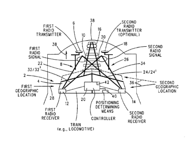
below:
[0030] FIG. 1 is a schematic drawing of one example of a system for
determining
a geographical location of a vehicle;
[0031] FIGS. 2A-2B are a flow diagram of one example of a method of
determining
a geographical location of a vehicle; and
[0032] FIGS. 3A-3B are a flow diagram of one example of a method of
determining
a geographical location of a vehicle.
DETAILED DESCRIPTION
[0033] Various examples will now be described with reference to the
accompanying figures where like reference numbers correspond to like or
functionally
equivalent elements.
[0034] For purposes of the description hereinafter, the terms "end,"
"upper,"
"lower," "right," "left," "vertical," "horizontal," "top," "bottom,"
"lateral," "longitudinal,"
and derivatives thereof shall relate to the example(s) as oriented in the
drawing figures.
9
Date Recue/Date Received 2021-05-13
However, it is to be understood that the example(s) may assume various
alternative
variations and step sequences, except where expressly specified to the
contrary. It is also
to be understood that the specific example(s) illustrated in the attached
drawings, and
described in the following specification, are simply examples or aspects of
the inventive
subject matter.
[0035] While one or more embodiments are described in connection with a
rail
vehicle system, not all embodiments are limited to rail vehicle systems.
Unless expressly
disclaimed or stated otherwise, the inventive subject matter described herein
extends to
other types of vehicle systems, such as automobiles, trucks (with or without
trailers), buses,
marine vessels, aircraft, mining vehicles, agricultural vehicles, or other off-
highway
vehicles. The vehicle systems described herein (rail vehicle systems or other
vehicle
systems that do not travel on rails or tracks) can be formed from a single
vehicle or multiple
vehicles. With respect to multi-vehicle systems, the vehicles can be
mechanically coupled
with each other (e.g., by couplers) or logically coupled but not mechanically
coupled. For
example, vehicles may be logically but not mechanically coupled when the
separate
vehicles communicate with each other to coordinate movements of the vehicles
with each
other so that the vehicles travel together (e.g., as a convoy).
[0036] The inventive subject matter described herein provides systems
and
methods that determine the location of a vehicle using at least one
transmitter and at least
two receivers. The transmitter may be off-board the vehicle and stationary,
while the
receivers are onboard the vehicle, or the transmitter may be onboard the
vehicle while the
receivers are off-board the vehicle and stationary. The transmitter emits
electromagnetic
oscillating signals (e.g., radio signals) having a phase and having the
geographic location
(e.g., coordinates) of the transmitter in the signals. The receivers are a
known or set distance
apart from each other. Because the receivers are in different locations, the
signals are
received by the receivers with different phases. For example, a signal can be
sent from the
transmitter and be received at a first receiver of the receivers before being
received at a
second receiver of the receivers. The time difference between when the
receivers receive
Date Recue/Date Received 2021-05-13
the signal results in the signal received at the first receiver having a
different phase than
the signal received at the second receiver. The systems and methods use (a)
the phase
difference, (b) a known, measured, or designated propagation rate (e.g.,
speed) at which
the signal travels from the transmitter to the receivers, (c) the known or
measured distance
between the receivers, and (d) the location of the transmitter to determine
the location of
at least one of the receivers to determine the location of the vehicle. If the
location of each
receiver is determined, then an average of the receiver locations that are
determined can be
calculated and used as the vehicle location. If the receivers are onboard the
vehicle, then
the calculations described above can be performed onboard the vehicle (e.g.,
by a controller
onboard the vehicle) with the location of the transmitter included in the
signals. If the
receivers are off-board the vehicle, then the calculations described above can
be performed
off-board the vehicle (e.g., by a controller that is not onboard the vehicle)
with the locations
of the receivers used instead of the location of the transmitter. The location
of the vehicle
that is determined can then be communicated to the vehicle (e.g., to the
controller that is
onboard the vehicle).
[0037] The
inventive subject matter described herein also provides systems and
methods that determine the location of a vehicle using at least two
transmitters and at least
one receiver. The transmitters may be off-board the vehicle and stationary,
while the
receiver is onboard the vehicle, or the transmitters may be onboard the
vehicle while the
receiver is off-board the vehicle and stationary. The transmitters emit
electromagnetic
oscillating signals (e.g., radio signals) having the same phase and having the
geographic
location (e.g., of the transmitter that emits the signal) in the signals. The
transmitters are a
known or set distance apart from each other. Because the transmitters are in
different
locations, the signals are received by the receiver with different phases. For
example, a first
signal can be sent from a first transmitter and be received at the receiver
before the receiver
receives a second signal sent from a second transmitter. The time difference
between when
the receiver receives the first and second signals results in the first signal
having a different
phase than the second signal. The systems and methods use (a) the phase
difference, (b) a
known, measured, or designated propagation rate (e.g., speed) at which the
signals travel
11
Date Recue/Date Received 2021-05-13
from the transmitters to the receiver, (c) the known or measured distance
between the
transmitters, and (d) the location of at least one of the transmitters to
determine the location
of the receiver to determine the location of the vehicle. If the receiver is
onboard the
vehicle, then the calculations described above can be performed onboard the
vehicle (e.g.,
by a controller onboard the vehicle) using the known location of at least one
of the
transmitters. If the receiver is off-board the vehicle, then the calculations
described above
can be performed off-board the vehicle (e.g., by a controller that is not
onboard the vehicle)
using the known location of the receiver (instead of the location(s) of the
transmitter(s)),
and the vehicle location is then communicated to the vehicle (e.g., to the
controller that is
onboard the vehicle).
[0038] With reference to FIG. 1, in one example, in a method of
determining a
geographical location of a multi-vehicle system 2, a first radio transmitter 6
can be
positioned at a first geographical location 8. The first radio transmitter can
be programmed
or configured to output a first radio signal 10 having a first geographical
location of the
first radio transmitter modulated thereon. A first vehicle of the vehicle
system (e.g., a
propulsion-generating vehicle 4, such as a locomotive) can have first and
second radio
receivers 12 and 14 mounted thereon. Alternatively, the vehicle system may be
formed
from a single vehicle. In an example, first and second radio receivers can be
positioned
laterally on opposite sides of the vehicle as shown in FIG. 1. In an example,
first and second
radio receivers can be positioned on the vehicle such that each radio receiver
can have an
unobstructed pathway for receiving the first radio signal from the first radio
transmitter as
the vehicle system travels on a route 16 toward the first radio transmitter in
the direction
of an arrow 38 in FIG. 1.
[0039] A controller 20 can be provided on the vehicle system for
processing the
output of the first radio receiver. Optionally, the controller may be off-
board the vehicle.
In an example, the controller can include one or more processors and memory.
The
controller can be part of or separate from the first radio receiver. The
controller can be
12
Date Recue/Date Received 2021-05-13
programmed or configured to process the output of the first radio receiver as
described
herein.
[0040] The controller can be programmed or configured to determine,
according to
a phase difference between the first radio signal received by the respective
first and second
radio receivers, a first distance 22 from first radio receiver to the first
radio transmitter and
a second distance from the second radio receiver to the first radio
transmitter. In one
example, the controller can be further programmed or configured to demodulate
or read
the first geographical location of first radio transmitter from the first
radio signal.
[0041] The controller can be programmed or configured to determine a
first
geographical location 28 of the vehicle from the first and second distances
and the first
geographical location of the first radio transmitter.
[0042] Hence, as can be seen, a single radio transmitter and two radio
receivers can
be utilized to determine the geographical location of the vehicle 4. In an
example, an
optional second radio transmitter can be used with the first radio transmitter
and the first
and second radio receivers to determine the geographical location of vehicle
4.
[0043] In one example, as an aid to enabling the geographical location
of the
vehicle 4 to be accurately determined, a second radio transmitter can be
provided at a
second geographical location 26. The first and second geographical locations
of the first
and second transmitters can be proximate to or on opposite sides of the route.
Optionally,
the first and second transmitters can be on the same side of the route. At
least the second
radio transmitter can be positioned at the second geographical location
relative to the first
geographical location of the first radio transmitter that is suitable and/or
desirable to enable
the second radio transmitter to transmit a second radio signal 30 to the first
and second
radio receivers. The first geographical location and the second geographical
location of the
first and second transmitters can be anywhere relative to each other that
enables the first
and second radio receivers to have access to and receive the first and second
radio signals.
13
Date Recue/Date Received 2021-05-13
[0044] On or about the same time that the first radio transmitter
generates the first
radio signal, the second radio transmitter can generate the second radio
signal having the
second geographical location of the second radio transmitter modulated
thereon.
[0045] The first and second radio receivers can receive the second
radio signal 30
in addition to receiving the first radio signal. In one example, the
controller 20 can
determine another phase difference between the second radio signal received by
the
respective first and second radio receivers. From this phase difference, a
third distance 32
from the first radio receiver to the second radio transmitter and a fourth
distance 34 from
the second radio receiver to the second radio transmitter can be determined,
as described
above.
[0046] The controller can demodulate or otherwise determine the second
geographical location of the second radio transmitter from the second radio
signal. In an
example, the controller then can determine a second geographical location 36
of the vehicle
from the third and fourth distances and the second geographical location that
was obtained
from the second radio signal.
[0047] The second geographical location 36 can be the same as the
first
geographical location 28. In another example, the second geographical location
36 can be
different than the first geographical location 28, as shown in broken lines in
FIG. 1, based
on, for example, the movement of the vehicle and the sequence of the
controller processing
the first and second radio signals.
[0048] Where the first and second geographical locations 28 and 36
determined by
the controller from the first and second radio signals are different, the
first and second
geographical locations can be combined by the controller in any suitable
and/or desirable
manner to obtain an estimate or calculation of the actual geographical
location of the
vehicle. For example, the controller can calculate an average of the first and
second
geographical locations as an estimate or calculation of the geographical
location of the
vehicle or vehicle system.
14
Date Recue/Date Received 2021-05-13
[0049] Once the controller has determined the first geographical
location 8 of the
first radio transmitter and the first and second distances 22, 24 from the
first radio signal,
the controller can utilize a triangulation distance measurement technique to
determine the
first geographical location 28 of the vehicle or vehicle system, as described
herein. In
another example, once the controller has determined the second geographical
location 26
of the second radio transmitter 18 and the third and fourth distances 32, 34
from the second
radio signal 30, the controller can utilize the triangulation distance
measurement technique
to determine the second geographical location 36 of the vehicle or vehicle
system. In an
example, the controller can execute the triangulation distance measurement
technique
separately for each of the first radio signal and the second radio signal.
[0050] In one example, the first radio transmitter and the second
radio transmitter
(when provided) can be located in a tunnel, valley, urban area, or other
location where
receipt of GNSS signals may be blocked or impeded.
[0051] Each radio receiver can be mounted on the lead vehicle of the
multi-vehicle
system, on a trailing (e.g., last) vehicle of the multi-vehicle system, or on
any other location
on the vehicle system that is suitable and/or desirable. In an example, each
radio receiver
can be mounted an end of train (EOT) device that can be mounted on a trailing
vehicle of
a train.
[0052] In one example, the first and second radio signals can be
transmitted at
different times to facilitate processing of the first and second radio signals
by the radio
receiver 12 and/or 14.
[0053] The controller can use a geographical location of the vehicle
or vehicle
system determined by the controller prior to the first and/or second radio
receivers
receiving the first radio signal and/or the second radio signal to enable the
controller to
resolve potential ambiguity in determining the first geographical location 28,
the second
geographical location 36, or both the first and second geographical locations
28, 36 of the
vehicle or vehicle system. In an example, this potential ambiguity can arise
from the
Date Recue/Date Received 2021-05-13
controller not being able to unambiguously determine whether the first and/or
second
geographical locations 28, 36 are on the side of the first radio transmitter
shown in FIG. 1,
or on the other side of the first radio transmitter (e.g., in the distance 16
shown in FIG. 1).
This prior geographical location can be determined by the controller from an
output of a
position determining means 40, such as a GNSS receiver (e.g., GPS receiver).
In an
example, the position determining means can be a GPS receiver which can
determine a
prior geographical location of the vehicle system from GPS satellite signals
received at a
time when the GPS satellite signals are available. In another example, the
location
determining means can be a gyroscope, such as a MEMS-based gyroscope. In
another
example, the position determining means can be a compass or a magnetometer. In
another
example, the position determining means can be a route database 42 that
includes a virtual
instance (or model) of the route or track upon which the controller can
monitor the progress
of the vehicle or vehicle system moving on the physical instance of the route
shown in FIG.
1.
[0054] In one example, the foregoing description describes the second
ratio
transmitter as optional, whereupon only a single, first radio transmitter and
two radio
receivers can be utilized to determine a geographical location of the vehicle
or vehicle
system.
[0055] In another example, the inventive system and method can
determine a
geographical location of the vehicle or vehicle system that utilizes two radio
transmitters
6, 18 and a single radio receiver 12 or 14.
[0056] The first and second radio transmitters 6, 18 located at the
first and second
geographical locations 8, 26 can generate the first and second radio signals
10, 30 having
the respective first and second geographical locations 8, 26 modulated
thereon. The first
radio receiver can receive the first and second radio signals. The controller
20 can
determine, according to a phase difference between the first and second radio
signals, the
first distance from the first radio receiver to the first radio transmitter
and a second distance
44 from the first radio receiver to the second radio transmitter.
16
Date Recue/Date Received 2021-05-13
[0057] In one example, the controller can obtain the first and second
geographical
locations 8, 26 of the first and second radio transmitters from the first and
second radio
signals. The controller can then determine a first geographical location 28 of
the vehicle or
vehicle system from the first and second distances 22, 44 and the first and
second
geographical locations 8, 26 obtained from the first and second radio signals.
[0058] As an aid to enabling the geographical location of the vehicle
or vehicle
system to be accurately determined, the second radio receiver optionally can
be provided
to receive the first and second radio signals. In an example, the controller
can, according
to a phase difference between the first and second radio signals received by
the second
radio receiver, determine a third distance 46 from the second radio receiver
to the first radio
transmitter and a fourth distance 34 from the second radio receiver to the
second radio
transmitter.
[0059] The controller can then determine a second geographical location
36 of the
vehicle or vehicle system from the third and fourth distances 46, 34 and the
first and second
geographical locations 8, 26 obtained from the first and second radio signals.
[0060] In an example, and as discussed above, the first and second
geographical
locations 28, 36 of the vehicle or vehicle system can be the same or
different. Where the
first and second geographical locations 28, 36 determined in the above manner
are
different, the geographical location of the vehicle or vehicle system can be a
combination
of the first and second geographical locations 28, 36. In an example, this
combination can
be the average of the first and second geographical locations 28, 36.
[0061] Each geographical location of the vehicle or vehicle system can
be
determined via a triangulation distance measurement technique executed by the
controller.
In an example, the controller can determine a fixed distance between the first
and second
radio transmitters from the first and second geographical locations 8, 26
demodulated from
the first and second radio signals. Via this fixed distance and distances 22,
44, the controller
can determine the first geographical location 28 utilizing a triangulation
distance
17
Date Recue/Date Received 2021-05-13
measurement technique. Similarly, utilizing the fixed distance between the
first radio
transmitter and the second radio transmitter and the distances 46, 34, the
controller can
determine the second geographical location 36 utilizing the triangulation
distance
determining technique.
[0062] The first and second radio transmitters can be located in
tunnel, valley,
urban area, or other location where GNSS signals may be unavailable or
impeded, or may
be in another location.
[0063] Each radio receiver can be mounted to the lead vehicle of the
multi-vehicle
system (e.g., the vehicle 4), a trailing vehicle of the vehicle system, or any
other location
on the vehicle system. In an example, the first and second radio signals can
be transmitted
at the same time or at different times.
[0064] With reference to FIGS. 2A-2B and with continuing reference to
FIG. 1, in
one example, a method of determining a geographical location of a vehicle
begins by
advancing from 50 to 52 where a first radio transmitter located at a first
geographical
location 8 generates a first radio signal having the first geographical
location 8 of the first
radio transmitter modulated thereon. At 54, the first and second radio
receivers mounted
on the vehicle receive the first radio signal. At 56, the first and second
distances 22, 24
from the first radio transmitter to the respective first and second radio
receivers are
determined according to the phase difference between the first radio signal as
received by
the first and second radio receivers.
[0065] At 58, the first geographical location 8 is demodulated from the
first radio
signal received by the first and/or second radio receivers. At 60, the first
geographical
location 28 of the vehicle or vehicle system is determined from the first and
second
distances 22, 24 (determined at 56) and the first geographical location 8
(determined at 58).
[0066] If, at 62, it is determined that the second radio transmitter is
not provided,
the method can advance toward a stop or termination of the method at 64 or can
repeat one
or more previous operations. But if the second radio transmitter is provided,
the method
18
Date Recue/Date Received 2021-05-13
can advance toward 66 where the second radio transmitter generates the second
radio signal
having the geographical location 26 of the second radio transmitter modulated
on the
second radio signal.
[0067] At 68, the first and second radio receivers receive the second
radio signal.
At 70, the third and fourth distances 32, 34 from the second radio transmitter
to the
respective first and second radio receivers are determined using a phase
difference between
the second radio signal as received by the first and second radio receivers.
At 72, the second
geographical location 26 is demodulated from the second radio signal. At 74, a
second
geographical location 36 of the vehicle or vehicle system is determined from
the third and
fourth distances 32, 34 (determined at 70) and the second geographical
location 26
(determined at 72). The method then advances to an end or termination at 64,
or can repeat
one or more previous operations.
[0068] In one example, each geographical location can be determined via
a
triangulation distance measurement technique. The actual geographical location
of the
vehicle system can be the first geographical location 28, the second
geographical location
36, or some combination (e.g., average) of the first and second geographical
locations
determined at 60 and/or 74.
[0069] With reference to FIGS. 3A and 3B and continuing reference to
FIG. 1, in
one example, a method of determining a geographical location of a vehicle
system or
vehicle advances from 80 to 82 where the first and second radio transmitters
generate first
and second radio signals having first and second geographical locations 8, 26
of the first
and second radio transmitters modulated thereon. At 84, a first vehicle-
mounted radio
receiver receives the first and second radio signals. At 86, first and second
distances 22, 44
from the first and second radio transmitters to the first radio receiver are
determined
according to a phase difference between the first and second radio signals
received by the
first radio receiver.
19
Date Recue/Date Received 2021-05-13
[0070] At 88, the first and second geographical locations 8, 26 are
demodulated or
otherwise obtained from the first and second radio signals. At 90, a first
geographical
location 28 of the vehicle or vehicle system is determined from the first and
second
distances 22, 44 (determined at 86) and the first and second geographical
locations 8, 26
obtained from the first and second radio signals (determined at 88).
[0071] If, at 92, it is determined that the second radio receiver is
not provided, the
method can terminate or otherwise end at 94, or may repeat one or more prior
operations.
If, however, the second radio receiver is provided, the method can advance
toward 96
where the second radio receiver receives the first and second radio signals
from the first
and second radio transmitters. At 98, third and fourth distances 46, 34 from
the first and
second radio transmitters to the second radio receiver 14 are determined
according to a
phase difference between cycles of the first and second radio signals received
by the second
radio receiver. At 100, a second geographical location 36 of the vehicle or
vehicle system
is determined from the third and fourth distances 46, 34 (determined at 98)
and the first
and second geographical locations 8, 26 (obtained at 98). The method then
advances to
stop or terminate at 94, or can repeat one or more prior operations.
[0072] The actual geographical location of the vehicle system can be
the first
geographical location, the second geographical location, or the combination
(e.g., average)
of the first and second geographical locations. Each geographical location of
the vehicle
system can be determined via a triangulation distance measurement technique.
[0073] As can be seen, disclosed herein is a system and method for
identifying the
position of a vehicle system when GNSS satellite signals are not available.
Triangulation
between two radio transmitters and a single vehicle-mounted radio receiver,
between a
single radio transmitter and two vehicle-mounted radio receivers, or between
two radio
transmitters and two vehicle-mounted radio receivers can be utilized to
determine the
geographical location of the vehicle system. The vehicle location that is
determined for the
vehicle or vehicle system can be used to control or change movement of the
vehicle system.
For example, the vehicle system can change direction, speed up, slow down, or
the like,
Date Recue/Date Received 2021-05-13
based on the location that is determined and/or changes in the locations that
are determined,
to remain on course toward a destination, to arrive at the destination within
a designated
period of time, to avoid collision with another object or vehicle system, or
the like.
[0074] Although the inventive subject matter has been described in
detail for the
purpose of illustration based on what is currently considered to be the most
practical,
preferred, and/or non-limiting embodiments, examples, or aspects, it is to be
understood
that such detail is solely for that purpose and that the inventive subject
matter is not solely
limited to the disclosed embodiments, examples, or aspects, but, on the
contrary, is
intended to cover modifications and equivalent arrangements that are within
the spirit and
scope of the appended claims. For example, it is to be understood that the
inventive subject
matter contemplates that, to the extent possible, one or more features of the
embodiment,
examples, or aspects can be combined with one or more features of any other
embodiment,
example, or aspect.
[0075] As used herein, the terms "processor" and "computer," and
related terms,
e.g., "processing device," "computing device," and "controller" may be not
limited to just
those integrated circuits referred to in the art as a computer, but refer to a
microcontroller,
a microcomputer, a programmable logic controller (PLC), field programmable
gate array,
and application specific integrated circuit, and other programmable circuits.
Suitable
memory may include, for example, a computer-readable medium. A computer-
readable
medium may be, for example, a random-access memory (RAM), a computer-readable
non-
volatile medium, such as a flash memory. The term "non-transitory computer-
readable
media" represents a tangible computer-based device implemented for short-term
and long-
term storage of information, such as, computer-readable instructions, data
structures,
program modules and sub-modules, or other data in any device. Therefore, the
methods
described herein may be encoded as executable instructions embodied in a
tangible, non-
transitory, computer-readable medium, including, without limitation, a storage
device
and/or a memory device. Such instructions, when executed by a processor, cause
the
processor to perform at least a portion of the methods described herein. As
such, the term
21
Date Recue/Date Received 2021-05-13
includes tangible, computer-readable media, including, without limitation, non-
transitory
computer storage devices, including without limitation, volatile and non-
volatile media,
and removable and non-removable media such as firmware, physical and virtual
storage,
CD-ROMS, DVDs, and other digital sources, such as a network or the Internet.
[0076] The singular forms "a", "an", and "the" include plural
references unless the
context clearly dictates otherwise. "Optional" or "optionally" means that the
subsequently
described event or circumstance may or may not occur, and that the description
may
include instances where the event occurs and instances where it does not.
Approximating
language, as used herein throughout the specification and claims, may be
applied to modify
any quantitative representation that could permissibly vary without resulting
in a change
in the basic function to which it may be related. Accordingly, a value
modified by a term
or terms, such as "about," "substantially," and "approximately," may be not to
be limited
to the precise value specified. In at least some instances, the approximating
language may
correspond to the precision of an instrument for measuring the value. Here and
throughout
the specification and claims, range limitations may be combined and/or
interchanged, such
ranges may be identified and include all the sub-ranges contained therein
unless context or
language indicates otherwise.
[0077] This written description uses examples to disclose the
embodiments,
including the best mode, and to enable a person of ordinary skill in the art
to practice the
embodiments, including making and using any devices or systems and performing
any
incorporated methods. The claims define the patentable scope of the
disclosure, and
include other examples that occur to those of ordinary skill in the art. Such
other examples
are intended to be within the scope of the claims if they have structural
elements that do
not differ from the literal language of the claims, or if they include
equivalent structural
elements with insubstantial differences from the literal language of the
claims.
22
Date Recue/Date Received 2021-05-13