Note: Descriptions are shown in the official language in which they were submitted.
INTEGRATED SEISMIC MONITORING SYSTEM AND METHOD
BACKGROUND
[0001] The present disclosure relates generally to techniques for
investigating subsurface
structures. More specifically, the present disclosure relates to optical
monitoring systems for
measuring seismic parameters of subsurface structures.
[0002] The exploration of oil and gas may involve the investigation of
subsurface
structures, such as geological formations and/or reservoirs. Seismic sensing
systems may be
positioned about a surface location for sensing properties of the subsurface
structures. Such
properties may include physical properties, such as pressure, motion, energy,
etc. Such
properties may occur naturally, or may be generated by imparting a force to
the surface using
a seismic energy source (e.g., a seismic vibration truck). Examples of seismic
vibration trucks
used for generating seismic vibrations are provided in US Patent Application
No.
2009/0238038. The reflected seismic waves generated by the seismic energy
source may be
collected and analyzed to determine characteristics of the subsurface
structures.
[0003] Techniques have been developed for sensing seismic parameters.
Examples of such
techniques are provided in US Patent/Application Nos. 20080062815,
20080060310, and
20080060311. Some seismic sensing systems may be, for example, optical systems
including
seismic trucks distributed about a location for independently collecting
seismic data. Each
seismic truck may have fiber optic cables with optical sensors distributed
about a surface of a
subsurface structure. The seismic trucks may also have a light source for
emitting a laser
through the fiber optic cables. The light source distributes light to and
collects light from the
optical sensors positioned along the fiber optic cables. The seismic truck may
have devices for
detecting changes in the light. Such changes may be used to determine
information about
and generate images of the subsurface structures. Examples of optical systems
and sensors
are provided in US Patent Nos. 7622706, 7222534, 7154082, and 6549488.
[0004] Despite the development of advanced techniques for optical seismic
monitoring, there
remains a need to provide advanced techniques for performing optical seismic
1
Date Recue/Date Received 2021-05-17
monitoring. The present subject matter is directed to fulfilling these needs
in the art.
2
Date Recue/Date Received 2021-05-17
SUMMARY
[0005] The present disclosure relates to an integrated seismic monitoring
system
positionable about a surface location to form an integrated network for
collecting seismic data
relating to subsurface structures. The integrated seismic monitoring system
includes a base
station, a plurality of mobile satellite nodes, and a seismic cable. The
plurality of mobile
satellite nodes has sensor stations operatively connectable thereto for
collecting seismic data
from the subsurface structure. The seismic cable operatively links the
plurality of mobile
satellite nodes and the sensor stations. The base station includes a seismic
acquisition unit for
receiving seismic signals from the mobile satellite nodes via the seismic
cable and generating
seismic parameters therefrom.
[0006] The seismic cable may include a fiber optic cable and the base station
may include a
light source for sending and receiving a light through the fiber optic cable.
The seismic cable
may link the base station to the mobile satellite nodes in series. The
satellite nodes may be
seismic trucks. The fiber optic cable may include fiber optic sections coupled
together. The
seismic acquisition unit may include recording media (e.g.. tape drives and/or
raid drives), a
source controller, an acquisition management system, spread Sz opto-
electronics, and/or a
generic acquisition system. The seismic cable may link the satellite nodes to
the base station
in a looped, a linear, a star, and/or a concentric ring configuration. The
sensor stations may be
connected to the satellite node by array cables.
[0007] The present disclosure also relates to an integrated method for
monitoring seismic
parameters of subsurface structures. The method involves providing an
integrated seismic
system including a base station and a plurality of mobile satellite nodes
(each of the satellite
nodes has sensor stations operatively connectable thereto), linking the mobile
satellite nodes
and the sensor stations with a seismic cable, collecting the seismic data from
the subsurface
structure with the sensor stations, and receiving seismic signals at a base
station from the
mobile satellite nodes via the seismic cable and generating seismic parameters
therefrom.
[0008] The method may also involve sending and receiving a light from a light
source at the
base station through the seismic cable and to the sensor stations. positioning
the mobile
satellite nodes and the sensor stations about the subsurface location,
analyzing the measured
seismic parameters, processing the measured seismic parameters, generating a
seismic
disturbance at the surface location, and correlating a position of the sensor
station (e.g., a GPS
location) with the seismic parameters.
3
Date Recue/Date Received 2021-05-17
[0008a] In accordance with a broad aspect there is provided an integrated
seismic system for
monitoring seismic parameters of a subsurface structure. The integrated
seismic system
comprises: a base station; a plurality of mobile satellite nodes, each of the
plurality of mobile
satellite nodes having sensor stations operatively connectable thereto for
collecting seismic data
from the subsurface structure; and a fiber optic cable extending from the base
station to the
plurality of mobile satellite nodes and operatively linking the plurality of
mobile satellite nodes
and the sensor stations; wherein the base station comprises: a light source
for sending a light
through the fiber optic cable, the light being distributed to the sensor
stations and, in the sensor
stations, experiencing a change or phase shift related to a physical property
being measured; and
a seismic acquisition unit for receiving the light returning from the
plurality of mobile satellite
nodes via the fiber optic cable, extracting phase information induced by said
change or phase
shift from the returning light, and generating seismic parameters therefrom.
[0008b] In accordance with a broad aspect there is provided an integrated
method for
monitoring seismic parameters of a subsurface structure. The method comprises:
providing an
integrated seismic system comprising a base station and a plurality of mobile
satellite nodes,
each of the plurality of mobile satellite nodes having sensor stations
operatively connectable
thereto, and a fiber optic cable extending from the base station to the
plurality of mobile satellite
nodes; operatively linking the plurality of mobile satellite nodes and the
sensor stations with the
fiber optic cable; sending a light through the fiber optic cable with a light
source at the base
station, the light being distributed to the sensor stations, the light in the
sensor stations
experiencing a change or phase shift related to a physical property being
measured from the
subsurface; receiving with a seismic acquisition unit at a base station phase
shifted light
returning from the plurality of mobile satellite nodes via the fiber optic
cable; and extracting
phase information induced by said change or phase shift from the returning
light and generating
seismic parameters therefrom.
[0008c] In accordance with a broad aspect there is provided a base station
of a seismic system
for monitoring seismic parameters of a subsurface structure, the seismic
system comprising: a
plurality of mobile satellite nodes each having sensor stations, the base
station being configured
to be connected to the plurality of mobile satellite nodes by a fiber optic
cable, the base station
comprising: a light source configured to send a light through the fiber optic
cable, the light being
3a
distributed to the sensor stations and, in the sensor stations, experiencing a
change or phase shift
related to a physical property being measured; and a seismic acquisition unit
for receiving the
light returning from the plurality of mobile satellite nodes via the fiber
optic cable, extracting
phase information induced by said change or phase shift from the returning
light, and generating
seismic parameters therefrom.
3b
Oat
BRIEF DESCRIPTION OF THE DRAWINGS
[0009] A more particular description of the subject matter, briefly summarized
herein, may
be had by reference to the embodiments thereof that are illustrated in the
appended drawings.
The figures are not necessarily to scale, and certain features and certain
views of the figures
may be shown exaggerated in scale or in schematic in the interest of clarity
and conciseness.
[00010] Figure 1 shows a schematic view of an integrated seismic system for
monitoring
seismic parameters of a subsurface structure, the system including a base
unit, mobile satellite
nodes and sensor stations linked by a fiber optic cable.
[00011] Figure 2 shows a schematic view of a portion 2 of the system of Figure
1 depicting
the mobile satellite node and sensor stations in greater detail.
[00012] Figure 3 shows a schematic view of a seismic acquisition unit.
[00013] Figure 4 is a flow chart depicting a method of monitoring seismic
parameters of a
subsurface structure.
DETAILED DESCRIPTION
[00014] The description that follows includes exemplary apparatuses, methods,
techniques,
and instruction sequences that embody techniques of the subject matter.
However, it is
understood that the described embodiments may be practiced without these
specific details.
[00015] Systems and methods for integrated seismic monitoring are provided.
The integrated
system includes a base unit, a plurality of mobile satellite nodes, and a
plurality of sensor
stations. A fiber optic cable joins the base unit to the multiple mobile
satellite nodes
distributed about a surface location for interactive operation therebetween.
Each of the
mobile satellite nodes has sensor stations for collecting seismic data
relating to a subsurface
formation. A single light source at the base unit may be used to send and
receive a laser light
to each seismic satellite node. The information from each of the seismic
satellite nodes may
be collected and manipulated at the base station.
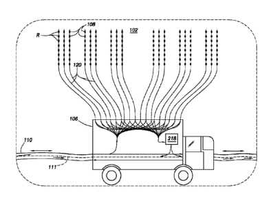
[00016] Figure 1 schematically depicts a system 100 for monitoring seismic
parameters of a
subsurface structure 102. The system 100 includes a base station (or camp)
104, multiple
mobile satellite nodes 106 and multiple sensor stations 108. The base station
104 may be a
consolidated or centralized location for controlling operations throughout the
system 100.
Operators may be stationed at the base station 104 for performing manual
and/or automatic
operations throughout the system 100. The mobile satellite nodes 106 may
optionally be
4
Date Recue/Date Received 2021-05-17
unmanned with operators located at the base station 104 for controlling
operations at each of
the satellite nodes 106.
[00017] The satellite nodes 106 may be seismic trucks or other mobile devices
or vehicles
deployable to various surface locations about the subsurface structure 102.
Each satellite
node 106 may have array (or seismic array) cables 120 linked to multiple
sensor stations 108
for collecting seismic data. A seismic cable 110 extends from the base station
104 and to each
of the satellite nodes 106. The seismic cable 110 may be deployed from the
base station 104
on a reel and extended to each of the sensor stations 108 for communication
therewith. A
communication network may be formed by linking the base station 104 to the
satellite nodes
106 and the sensor stations 108 via the seismic cable 110. The seismic cable
110 may be a
unitary cable, or multiple cables joined together to form a single cable.
Connectors for joining
cables are described in US Patent No. 6827597.
[00018] Any cable capable of communicating between the base station 104 and
the sensor
stations 108 may be used, The seismic cable 110 may be, for example, a
conventional fiber
optic cable used in seismic surveying. Conventional fiber optic cables, such
as a steel
armored optical cable with optical fibers inside gel-filled stainless steel
tubes, may be used.
In some cases, portions of the integrated seismic system may have additional
or other
communication links using wired or wireless communication links therebetween.
[00019] The base station 104 may have a light source 112 including a laser for
emitting a
laser light 111 through the seismic cable 110. Examples of techniques for
passing laser light
through a fiber optic cable are described in US Patent No. 7622706, A seismic
detector 114
may be provided for detecting changes in the laser light 111. A processor 116
may also be
provided for analyzing the changes and determining seismic parameters
therefrom. A seismic
acquisition unit 118 may be provided at the base station 104 for receiving the
light 111 and
determining seismic parameters therefrom as will be described further herein.
The satellite
nodes 106 may be provided with the same capabilities of the base station 104
for operating
independently thereof as desired.
[00020] A selected length of optical cable 110 may be used to carry light from
the light
source, which is distributed to the various sensor stations 108 in the seismic
system 100. The
light in the sensor stations 108 experiences a change or phase shift related
to the physical
property being measured. Changes in optical characteristics of the optical
fibers causes
changes in the properties of the applied light which may be detected by one of
a number of
Date Recue/Date Received 2021-05-17
different optical measurement techniques. Optical signals from the sensor
stations 108 are
then collected and returned to a receiving device for demultiplexing and
analyzing the signals
from each sensor station 108.
[00021] Examples of fiber optic cables are provided in U.S. Pat. No.
6.850.461. The fiber
optic cable may use wavelength-division multiplexing (WDM) and/or frequency
division
multiplexing (FDM) techniques in which optical splitting of source light from
an input bus to
individual sensors and recombination of signals from the individual sensors
are made in
discrete modules, such that optical splicing and splitting or recombining
components are
mechanically isolated from other portions of the cable. Portions of the cable
and/or sensor
stations may be replaceable to address any failures that may occur in the
system.
[00022] A seismic source 119 may be provided for producing impact, vibration,
explosion or
other seismic events to generate seismic waves through the subsurface
structure 102.
Conventional seismic sources, such as a seismic vibration truck may be used
(see, e.g., US
Patent Application No. 2009/0238038). In some cases, the seismic satellite
nodes 106 may be
capable of generating seismic waves in the subsurface structure 102. The
integrated seismic
system 100 may be positioned about the seismic source 119 and/or subsurface
structure 102
for measuring seismic parameters generated by the seismic source 119.
[00023] A data network ring may be set up from the base station 104 to the
satellite nodes
106 to communicate the status of the system 100 during the seismic
acquisition. The
integrated seismic system 100 may form a seismic network about the surface of
the
subterranean structure. One or more satellite nodes 106 may be linked to the
base station 104
to form the network. The satellite nodes 106 may be positioned at various
locations about the
surface of the subsurface structure 102. The seismic cable 110 may extend from
the base
station 104 to the satellite nodes 106 in series or in discrete intervals.
[00024] As shown in Figure 1, the satellite nodes 106 form a continuous loop
extending from
the base station 104 to each of the satellite nodes in series and back to the
base station 104.
The satellite nodes 106 may be positioned in various configurations, such as
the loop (or ring),
a star, a linear, and/or other configurations. Various combinations of
continuous and/or linear
configurations may be used to provide a variety of configurations. The light
source 112 at the
base station 104 may emit a light 111 for passing through each of the
satellite nodes 106 and
returning to the base station 104. In a continuous configuration, such as a
loop, ring or star,
the light 111 may pass through the fiber optic cable 110 and continue to the
seismic
6
Date Recue/Date Received 2021-05-17
acquisition unit 118 therein as indicated by the dashed arrow. In a linear
configuration, the
light source 112 may emit a light 111 therethrough and receive it back
therethrough. As
indicated by the two way solid arrow, data may pass both ways through system
100 via the
seismic cable 110.
[00025] The satellite nodes 106 may be processing units with, for example,
about a 72,000
channel capacity. Acquisition survey needs may require systems having about
one million or
more channels. Multiple satellite nodes 106 may be deployed for providing the
necessary
channel capabilities. The integrated network formed by the system 100 may be
used to
operate the channels provided by multiple satellite nodes 106 from a single
location. The
seismic acquisition unit 118 may be used to receive and process the data from
the multiple
nodes and to perform necessary quality control (QC) and operational control.
The integrated
configuration provided by the system 100 may be used to compare data from
multiple sources,
eliminate redundancies, and provide an integrated analysis of the data.
[00026] Figure 2 shows a schematic view of a portion 2 of the seismic system
100 of Figure
1. This figure also shows one of the satellite nodes 106 (depicted as a
seismic truck) and the
sensor stations 108 in greater detail. As shown, multiple array cables 120
extend from the
satellite node 106, with each array cable 120 having multiple sensor stations
108. The sensor
stations 108 may be operatively connectable to the satellite node 106 for
interaction therewith.
The sensor stations 108 may be carried by the seismic cable 110, or connected
thereto at the
surface locations. The sensor stations 108 may be conventional optical sensors
positionable
about the surface locations for measuring seismic parameters of the subsurface
structure 102.
The optical sensors may be, for example, hydrophones, accelerometers, or
geophones, for
sensing physical properties, such as subsurface motion, energy or changes in
pressure. The
sensor stations 108 may have radio frequency identification (RFID) tags R
containing
information, such as identifiers, for each sensor station.
[00027] The sensor stations 108 may be connected to a sensor pad on the
seismic cable 110.
By way of example, the sensor pads may be located about every 25m along the
seismic cable
110. The sensor stations 108 may be positioned at various locations and used
to generate an
optical signal in response to the sensed physical properties. The optical
signal may be, for
example, a change in wavelength, a change in phase or an interference pattern
in response to
changes in the physical parameter. Examples of optical sensor stations are
provided in US
Patent Nos. 7154082, and 6549488. Multiple sensor stations 108 may be
multiplexed from
7
Date Recue/Date Received 2021-05-17
the light source 112 at the base station 104 and signal return optical fibers
using optical
telemetry systems.
[00028] As shown in Figure 2, the seismic cable 110 enters the satellite node
106 from the
base station 104 and is split out into the array cables 120. The seismic cable
110 continues
through the satellite node and on to the next satellite node(s) and back to
the base station 104.
Communication with the base station 104 may be provided with the satellite
node 106 and/or
sensor stations 108 for determining seismic parameters. The laser light 111
may pass through
the seismic cable 110, through the satellite node 106 and out on to the base
station 104 as
indicated by the dashed arrows. The laser light 111 is also directed through
the sensor cables
and returned back to the satellite node 106. When the laser light 111. passes
from the base
station 104 to the satellite nodes 106, the satellite nodes 106 collect,
amplify and redistribute
the light.
[00029] The seismic cable 110 may also be used to pass data between the
satellite node 106
and back to the base station 104 as indicated by bidirectional arrows. The
data may be
directed to the seismic acquisition unit 118 of Figure 1. The satellite node
106 may house its
own seismic acquisition unit 218 for collecting and recording seismic data for
its sensor
stations 108. The seismic acquisition units 118 and/or 218 may receive the
light 111 that
passes to the sensor stations 108 and is returned therefrom, and may determine
seismic
parameters as will be described further herein. The seismic acquisition unit
218 may have
part or all of the functionality of the seismic acquisition unit 118 of Figure
1.
[00030] Figure 3 is a schematic view of system architecture that may be used
as the seismic
acquisition unit 118 of the base station 104 of Figure 1 and/or the seismic
acquisition unit 218
of the satellite node 106 of Figure 2. The seismic acquisition unit 118/218
includes electronic
components including an acquisition management system 330, a QC/Processing
System 332,
recording media 334, 335, spread & optoelectronics 336, a source controller
338, and an
acquisition recorder (or generic acquisition system (sometimes referred to as
"gAS?")) 340.
Various links may be provided between the electronic components for operative
connection
therebetween.
[00031] The source controller 338 provides communication between an operator
at the base
station and the satellite nodes 106. Data from the satellite nodes 106 is
passed from the
source controller 338 to the acquisition management system 330. The
acquisition
management system 330 provides communication between an operator at the base
station 104
8
Date Recue/Date Received 2021-05-17
and the satellite nodes 106. Data from the satellite nodes 106 is passed back
to the acquisition
management system 330. The acquisition management system may also communicate
with
the source controller 338 to provide vibrator information to be stored along
with the data. The
acquisition management system 330 acts as a central processing unit (CPU) for
processing all
of the data of the seismic acquisition unit 118/218. The acquisition
management system 330
also communicates with the QC/Processing system 332 and the spread &
optoelectronics 336.
The QC/Processing system 332 may be a network computer used for data
manipulation, such
as signal processing, visualization of data, etc. Data from the QC/Processing
system 332 may
be passed to an individual record storage 334 for recording. The individual
record storage
334 may be a recording media, such as tape drives for storing the data.
[00032] The spread & optoelectronics 336 receives signals from the satellite
nodes 106 and
converts the signals into seismic data for recording. The seismic data may be
passed from the
spread & optoelectronics 336 to the acquisition recorder 340 for formatting by
an Ethernet
connection. The acquisition recorder 340 formats the seismic data for
recording. The
formatted data may be passed to a recording media 335, such as a continuous
data storage, for
recording. The data storage 335 may be a recording media, such as a raid drive
for storing the
data.
[00033] The system architecture enables the seismic acquisition and QC
functions to take
place in the centralized base station 104. The satellite nodes 106 may also
perform certain
functions, such as initial quality control (QC) functions, at the seismic
acquisition unit 218
and report status back the seismic acquisition unit 118 of the base station
104 where the main
control takes place. Information may be provided at multiple levels to provide
redundancy,
cross-checks, and interpretation.
[00034] The seismic acquisition unit 118/218 may also be used to collect
information from
the RFID tags R of the sensor stations 108. The computers in the system and/or
additional
RFID units may be provided to communicate with and/or collect information from
the RFID
tags. The RFID tags R may be scanned by an RFID unit (not shown) during or
after
deployment to the field 102 to identify the RFID unit by location along the
surface location
102. The RFID unit may also have an RFID sensor for receiving data from and
logging the
sensor stations. This information may be used with the data collected by the
seismic cable
110 and/or sensor stations 108 to, for example, correlate seismic data with
location and/or
9
Date Recue/Date Received 2021-05-17
sensor information specific to the identified sensor station 108.
[00035] The seismic acquisition unit 118/218 may have processors/computers to
provide
such correlations. For example, the seismic acquisition unit 118/218 may have
a global
positioning satellite (GPS) tracker that gathers information from the RFID
tags that may be
used to plot a position of the sensors using. Information concerning a
location of each sensor
may be determined using conventional GPS technology linked to an output from
each sensor
station 108. The GPS data may provide position data in a three dimensional
axis. Z-axis data
may provide elevation information so that the sensor stations may be corrected
to a similar flat
datum. X-axis and Y-axis data may position data so that digital filters can be
provided to
remove additional error. The gathered GPS data for each sensor station may be
correlated
with the data collected by the sensor station for further analysis. The
analyzed information
may be used to determine subsurface properties at a given location.
[00036] In operation, dense wavelength division multiplexing (DWDM) may be
used in the
integrated seismic system 100 to optically power the sensor stations 108. By
way of example,
an optoelectronic cabinet may be assembled using 10 wavelengths with the
capacity to run
960 sensor or 240 4C channels. Multiplexed and modulated light 111 may be sent
into the
seismic cable 110 and the array cables 120 to the sensor stations 108. The
light 111 returning
from the sensor stations 108 may be demultiplexed and demodulated. A phase
modulated
laser light 111 passes through an interferometer in the sensor station 108.
Stress from the
outside world causes a phase shift in the light 111 as it passes through the
interferometer.
Using the seismic acquisition system 118/218, the phase information is
extracted from the
returning light to output a signal equivalent to the stress input at the
sensor station 108. This
provides a passive system with no electronics.
[00037] The light source 112 generates the optical power for the array of
sensor stations 108,
and processes the returned optical signals to extract the seismic information.
Light 111
returning from the sensor array cables 120 may be routed to a select group of
demodulation
boards to process the optical data, and outputs a 'word' (e.g., a 32-bit
digital word) equal to
the seismic data. The data may be processed by the seismic acquisition unit
118 (e.g., a
network interface card), where it is put into data packets, and sent to the
data storage 334, 335.
[00038] Figure 4 is a flowchart depicting a method 400 of monitoring seismic
parameters of
a subsurface structure 102. The method 400 involves providing an integrated
seismic system
such as the system 100 of Figure 1 (e.g., including a base station 104 and a
plurality of
Date Recue/Date Received 2021-05-17
satellite nodes 106 and a plurality of sensor stations 108). The method also
involves
positioning (482) the satellite nodes and the sensor station about a surface
location, generating
(483) a seismic disturbance at the surface location, linking (484) the mobile
satellite nodes
and the sensor station with a seismic cable, passing (486) a light from the
laser through the
optical cable, collecting (488) seismic data from the subsurface structure
with the sensor
station by detecting disturbances in the light, and receiving (490) seismic
signals at the base
station from the mobile satellite nodes via the seismic cable and generating
seismic
parameters therefrom.
[00039] The method may also involve analyzing the measured seismic parameters.
Other
steps may also be performed, such as performing a quality control check,
and/or capturing
and/or correlating information from the sensed RFID tags with the subsurface
data collected
by the sensor stations. The steps may be performed automatically or manually,
in any order
and repeated as desired.
[00040] While the present disclosure describes configurations, numerous
modifications and
variations will become apparent to those skilled in the art after studying the
disclosure,
including use of equivalent functional and/or structural substitutes for
elements described
herein. For example, aspects of the subject matter may include two or more
seismic trucks (or
nodes) connected by one or more seismic cables, and have one or more sensor
stations.
[00041] Plural instances may be provided for components, operations or
structures described
herein as a single instance. In general, structures and functionality
presented as separate
components in the exemplary configurations may be implemented as a combined
structure or
component. Similarly, structures and functionality presented as a single
component may be
implemented as separate components.
11
Date Recue/Date Received 2021-05-17