Note: Descriptions are shown in the official language in which they were submitted.
CA 03121627 2021-05-31
WO 2020/118189 PCT/US2019/064950
-1-
SCANNING MODE APPLICATION OF NEUTRON GAMMA ANALYSIS FOR SOIL
CARBON MAPPING
CROSS-REFERENCE TO RELATED APPLICATIONS
[0001] This application claims the benefit under 35 USC 119(e) of U.S.
Provisional
Application Serial No. 62/776,822, filed on December 7, 2018, the entire
disclosure of which is
incorporated herein by reference.
TECHNICAL FIELD
[0002] The present disclosure relates to systems and methods for mapping a
distribution
of at least one compound within soil.
BACKGROUND
[0003] Elemental content analysis of soil of a given geographic area may
reveal whether
the soil is adaptable to particular uses, such as agricultural, recreational,
and so on. Other uses
of soil content analysis include determining carbon credits and the level of
availability of nutrients
or the need for nutrient introduction to evaluate present and projected yields
and potential
profitability of fertilization.
[0004] Soil analysis may begin with soil sample collection, such that only
a tiny portion
of a field is actually analyzed in the laboratory. For example, one common
method of soil
elemental content analysis is composite sampling, where several subsamples of
the soil are
collected from randomly selected locations in the field. The subsamples are
then mixed and the
mixture analyzed for elemental content. In some instances, a quantity of a
given element revealed
to be contained within the mixture may be treated as an average quantity of
that element within
the entire area of the field being analyzed.
[0005] While an actual number of subsamples may vary slightly based on
field size and
uniformity, a number of subsamples usually does not exceed 20 and, at times,
amounts to less
than 0.01% of the acreage being analyzed. Moreover, most soil testing and
analysis systems are
not readily adaptable to test more than a few samples and, at best, provide a
high-level
approximation of a true elemental content of the soil of the field. Since the
importance of
accuracy of elemental content of the soil cannot be overstated, a methodology
yielding more
detailed and accurate elemental content information for a given field area is
needed.
CA 03121627 2021-05-31
WO 2020/118189 PCT/US2019/064950
-2-
SUMMARY
[0006] A system for analyzing soil content of a field, the system includes
a data
acquisition unit configured to detect gamma spectra of each of a plurality of
soil samples, wherein
a surface area of the field is divided into a plurality of portions and the
plurality of soil samples
comprises at least one soil sample from each of the plurality of portions, a
navigation unit
configured to detect geographic coordinates of each of the plurality of soil
samples, a data
analysis unit configured to associate the detected gamma spectra of each of
the plurality of soil
samples with the geographic coordinates of the soil sample and determine a
weight percent of at
least one element within each of the soil samples based on the detected gamma
spectra, and an
element content map unit configured to generate a map indicating concentration
of the at least
one element within the soil of the field.
[0007] A method for analyzing content of soil of an agricultural field, the
method includes
dividing a surface area of the field into a plurality of portions, scanning at
least one soil sample
within each of the portions to detect gamma spectra of the soil sample,
associating the detected
spectra with a geographic location of the soil sample, calculating, based on
the detected spectra,
an amount of at least one element within the soil sample, and generating a map
indicating the
amount of the at least one element within each portion of the field.
[0008] A system for analyzing elemental content of soil of a field, the
system includes a
data acquisition unit configured to collect gamma spectra of at least one soil
sample, a navigation
unit configured to provide geographic coordinates of the soil sample, a data
analysis unit
configured to associate the collected gamma spectra with the geographic
coordinates of the soil
sample and calculate a weight percent of an element within the soil sample,
and an element
content map unit configured to generate a map indicating a concentration of
the at least one
element within the soil sample based on the calculated weight percent.
BRIEF DESCRIPTION OF THE DRAWINGS
[0009] The concepts described in the present disclosure are illustrated by
way of example
and not by way of limitation in the accompanying figures. For simplicity and
clarity of
illustration, elements illustrated in the figures are not necessarily drawn to
scale. For example,
the dimensions of some elements may be exaggerated relative to other elements
for clarity.
Further, where considered appropriate, reference labels have been repeated
among the figures to
CA 03121627 2021-05-31
WO 2020/118189 PCT/US2019/064950
-3-
indicate corresponding or analogous elements. The detailed description
particularly refers to the
accompanying figures in which:
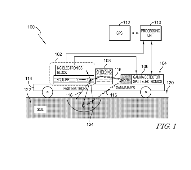
[0010] FIG. 1 is a simplified diagram illustrating an example
implementation of a gamma
analysis apparatus;
[0011] FIGS. 2A-2B are simplified diagrams illustrating example mobile
implementations of the gamma analysis apparatus;
[0012] FIG. 3 is a simplified diagram illustrating a plurality of portions
of a field to be
scanned by the gamma analysis apparatus;
[0013] FIG. 4A is a graph illustrating an example relationship between a
peak area and a
weight percent of silicon;
[0014] FIG. 4B is a graph illustrating a portion of the graph illustrated
in FIG. 4A;
[0015] FIG. 5 is a graph illustrating an example relationship between a
gamma analysis
yield and energy of potassium;
[0016] FIG. 6 is a simplified diagram illustrating an example methodology
for
determining potassium content of the soil;
[0017] FIG. 7 is a simplified diagram illustrating a plurality of portions
of a first scanned
field;
[0018] FIG. 8 is a simplified diagram illustrating a map of carbon
distribution of the first
scanned field;
[0019] FIG. 9 is a simplified diagram illustrating a map of silicon
distribution of the first
scanned field;
[0020] FIGS. 10 and 11 are simplified diagrams illustrating maps generated
from scan
operations of a second scanned field performed on two different days;
[0021] FIGS. 12 is a simplified diagram illustrating a map of carbon
distribution based
on a combination of scan data of FIGS. 10 and 11;
[0022] FIG. 13 is a simplified diagram illustrating a map of silicon
distribution of the
second scanned field;
[0023] FIGS. 14 and 15 are simplified diagrams illustrating, respectively,
a first map
generated using methods of the present disclosure and a second map generated
based on moisture
measurements performed simultaneously with the first map; and
[0024] FIGS. 16A and 16B are block diagrams of an example process algorithm
for
determining elemental content of soil of a field.
CA 03121627 2021-05-31
WO 2020/118189 PCT/US2019/064950
-4-
DETAILED DESCRIPTION OF THE DRAWINGS
[0025] While the concepts of the present disclosure are susceptible to
various
modifications and alternative forms, specific embodiments thereof have been
shown by way of
example in the figures and will be described herein in detail. It should be
understood, however,
that there is no intent to limit the concepts of the present disclosure to the
particular forms
disclosed, but on the contrary, the intention is to cover all modifications,
equivalents, and
alternatives consistent with the present disclosure and the appended claims.
[0026] References in the specification to "one embodiment," "an
embodiment," "an
illustrative embodiment," etc., indicate that the embodiment described may
include a particular
feature, structure, or characteristic, but every embodiment may or may not
necessarily include
that particular feature, structure, or characteristic. Moreover, such phrases
are not necessarily
referring to the same embodiment. Further, when a particular feature,
structure, or characteristic
is described in connection with an embodiment, it is submitted that it is
within the knowledge of
one skilled in the art to effect such feature, structure, or characteristic in
connection with other
embodiments whether or not explicitly described.
[0027] The disclosed embodiments may be implemented, in some cases, in
hardware,
firmware, software, or any combination thereof. The disclosed embodiments may
also be
implemented as instructions carried by or stored on a transitory or non-
transitory computer-
readable storage medium, which may be read and executed by one or more
processors. A
computer-readable storage medium may be embodied as any storage device,
mechanism, or other
physical structure for storing or transmitting information in a form readable
by a computing
device (e.g., a volatile or non-volatile memory, a media disc, or other media
device).
[0028] In the drawings, some structural or method features may be shown in
specific
arrangements and/or orderings. However, it should be appreciated that such
specific
arrangements and/or orderings may not be required. Rather, in some
embodiments, such features
may be arranged in a different manner and/or order than shown in the
illustrative figures.
Additionally, the inclusion of a structural or method feature in a particular
figure is not meant to
imply that such feature is required in all embodiments and, in some
embodiments, may not be
included or may be combined with other features.
[0029] An example system for developing a detailed and accurate elemental
content of
soil of a given field may include a neutron generator device and a plurality
of gamma detectors
(e.g., sodium iodine gamma detectors) for scanning at least a portion of the
field and a computing
CA 03121627 2021-05-31
WO 2020/118189 PCT/US2019/064950
-5-
system for storing and analyzing the results of the scan and generating a map
indicative of
elemental content of the portion of the field. The example system may be a
mobile system and
may be configured to travel over a substantial portion of the field to perform
the scan of the soil.
According to some embodiments of the present disclosure, the elemental (C, Si,
0, H, K, Cl, and
others) content in soil may be calculated using the measured spectra captured
by the gamma
detectors.
[0030] The example system may be further configured to communicate to a
global
positioning system (GPS) device to capture geographic location of the soil
during the scanning
process. In one example, the elemental content data identified during the scan
may be combined
(or associated) with geographic coordinates provided by the GPS device.
Additionally or
alternatively, based on the elemental content determined from the scan and the
associated
geographic coordinates, the example system may be configured to generate an
element
distribution map suitable for agricultural and other purposes.
[0031] FIG. 1 illustrates an example system 100 for analyzing soil samples
124 of a field
120. The system 100 may comprise one or more components for soil elemental
analysis. In one
example, the system 100 includes a neutron generator device 102, a plurality
of gamma detectors
104, split electronics 106, and a processing unit (or processor) 110. While
not separately
illustrated, the example system 100 may include one or more additional or
alternative
components, such as, but not limited to, processing and memory / data store
units and devices,
audio and video scanning devices, and so on, configured to acquire, process,
store, and/or analyze
elemental analysis data. Additionally or alternatively, any neutron pulse
source 102 could be
used, and this disclosure is not limited to a neutron generator 102.
Furthermore, accelerator-
based neutron sources, such as deuterium-deuterium (D-D) and deuterium-tritium
(D-T) fusion
neutron generators and others that allow for electronic control of neutron
emission 118 are
preferred. The D-T neutron generators, in particular, may be preferred in
practicing the present
invention. Such generators may be pulsed (i.e., turned off and on for various
lengths), providing
electronic control of neutron emission 118.
[0032] The processing unit 110 may be configured to monitor and operate the
neutron
generator device 102, the gamma detectors 104, and the split electronics 106
to conduct scanning
of the soil 120 and analysis of the spectra data collected during the scan.
The system 100 may be
in communication with a global positioning system (GPS) device 112 to receive
one or more
geographic coordinates. In an example, the processing unit 110 may be
configured to request
geographic coordinates indicative of a geographic location of a soil sample
124. In another
CA 03121627 2021-05-31
WO 2020/118189 PCT/US2019/064950
-6-
example, the processing unit 110 may associate the received geographic
location of the soil
sample 124 with data indicative of detected gamma spectra 116 of that soil
sample 124.
[0033] One or more components of the system 100 may be disposed on and/or
secured to
a fixture, a cart, or another rigid or semi-rigid structure 114. The structure
114 may be self-
propelled, or driven directly or remotely, to travel over at least a portion
of the field 120 to scan
the soil 122. FIG. 2A illustrates an example mobile implementation 200-A of
the soil analysis
system 100, wherein at least a portion of the system 100 is disposed in a
trailer 202. The trailer
202 may be pulled 204 across the field 120 by a motorized vehicle 206, whether
gas- or battery-
powered. Additionally or alternatively, FIG. 2B illustrates an example mobile
implementation
200-B of the system 100, wherein one or more components of the system 100 are
disposed on
and/or secured to a remote-controlled pilotless aircraft, such as a drone 220.
[0034] FIGS. 3-15 illustrate example processes performed by the system 100
to scan soil
of the field 120, analyze and store scanned data corresponding to the soil 122
of the field 120,
and to generate an elemental content map of the field 120 based on the
spectral data acquired
during the scan. One or more processes, such as, but not limited to, analyses,
computations, and
map generation tasks may be performed by the processing unit 110. Additionally
or alternatively,
scan data collected by one or more components of the system 110 during the
scan may be
downloaded or otherwise extracted from the system 100 and exported for further
processing on
a remote (e.g., cloud-based) computing system. Other scan data collection,
processing, and
analysis methods are also contemplated.
[0035] FIG. 3 illustrates an example diagram 300 of an area 302 to be
scanned by the soil
analysis system 100. In one example, the processing unit 110 of the system 100
may be
configured to divide the field 120 into a plurality of portions (blocks, or
sites) 306 prior to
initiating the scanning operation. In some instances, the number of portions
(hereinafter, sites)
306 may be based on the field size and presence of one or more landscape
features. For example,
when determining the sizes of the sites 306, the appropriate speed for
scanning (e.g., ¨5 km/h)
and the terrain profile may be considered. Each site 306 may comprise a
relatively homogeneous
terrain profile. During field division, the processing unit 110 of the system
100 may be
configured to designate a separate site 306 in response to detecting a change
in terrain type, such
as an asphalt road 308 crossing the field 120 and so on, and/or detecting a
change in a profile and
make-up of the terrain, e.g., in response to detecting a low spot in the
terrain. Given the
aforementioned terrain-related and other factors affecting scanning
conditions, each site 306 of
the plurality of sites 306 may vary in size from less than ¨100 m2t0 ¨1000 m2
and greater. In the
CA 03121627 2021-05-31
WO 2020/118189 PCT/US2019/064950
-7-
example illustrated in FIG. 3, a total area of the field 120 was approximately
800 m2 and a number
of sites was 12.
[0036] The processing unit 110 of the system 100 may be configured to scan
the soil 122
for a predefined period of time in order to achieve a predefined desired
accuracy value in
identifying a presence or absence of a given element within the soil 122 of
the site 306 and/or in
measuring an amount of the element within the soil 122 of the site 306. In
some instances, a
period of time for which the processing unit 110 of the system 100 scans each
site 306 may be
based on a gamma peak yield of the element, that, in turn, may be affected by
an amount of that
element within the soil of the site 306, a chemical, molecular, and/or
anatomic structure of the
element being identified, and one or more other characteristics.
[0037] Additionally or alternatively, the period of time for which to scan
each site 306
based on a predefined desired accuracy value of the measurement. For instance,
to reach an
accuracy of 0.5 w% for carbon content measurements, the acquisition time for
one site may be
15 mm. As another example, the system 100 measurement time for silicon with an
acceptable
accuracy of 0.5-1 w% may be ¨5 mm, due to silicon gamma peak yield for
silicon being several
times greater than carbon peak yield (due to its higher content in soil 122).
[0038] The system 100 may be configured to identify a geographic position,
e.g.,
geographic coordinates, of each of the plurality of sites 306 and to mark and
number each site
306 on a digital rendering of a map. In one example, the processing unit 110
of the system 100
may be configured to request and receive the geographic coordinates of each
site 306 from the
GPS unit 112 (internal or external to the system 100) with which the system
100 communicates
using, for example, a wired network connection, another type of network
communication
medium, or a long-range or a short-range wireless network, such as, but not
limited to wireless
local area network (LAN), Bluetooth, wide area network (WAN), and so on.
Accordingly, the
processing unit 110 of the system 100 may be configured to acquire and track a
current
geographic position of the system 100 with respect to the ongoing path are
displayed over a map
of the sampling field at runtime.
[0039] During the scanning operation, the system may determine, for each
individual site
306, a period of time during which gamma spectra of the soil 122 has been
scanned for the site
306. The processing unit 110 of the system 100 may be configured to alter a
color of a given site
306 on the displayed map responsive to a period of time during which the soil
122 of that site
306 has been scanned. In some instances, the system may change or alter a
color of the site 306
on the displayed map based on a total acquisition time collected within each
site 306 during the
CA 03121627 2021-05-31
WO 2020/118189 PCT/US2019/064950
-8-
scan runtime. In one example, the processing unit 110 of the system 100 may
use color-coding
to indicate that a predefined sufficient amount of data has been acquired for
accurate soil element
determination for that site 306, such as when all of the sites 306 have turned
a predefined color,
the processing unit 110 may issue a corresponding command and/or notification
indicating that
the scanning operation has been completed.
[0040] The INS and TNC spectra from each detector 104 acquired during the
scanning
are displayed on the laptop screen at runtime. The processor 110 may be
configured to store at
predefined periods, e.g., every 30 s, the gamma spectra (the INS and TNC
spectra from each of
the gamma detectors 104) of the soil 122 of a given site 306 and the
corresponding geographical
coordinates of that site 306. The system 100 may be configured to regularly
check whether a
connection is maintained between the GPS device 112 and the processing unit
110 and/or memory
in the recording equipment. Further, in response to detecting that the
connection between the
GPS device and the recording equipment has been lost, the system 100 may be
configured to
issue a corresponding alert and may pause the recording of the scanning data
to prevent inaccurate
data from being recorded. In some instances, a total number of saved spectra
may reach several
thousand or more depending on the scanning time. After scanning, the saved
spectra may be
transferred to one or more data processing component (not shown) of the system
100.
[0041] At the beginning, the net INS spectra for every 30 s measurement are
calculated.
[0042] The net INS spectra (netINSr,i) in counts per second (cps) per
channel for each r-
th record and each i-th detector 104 may be calculated using Equation (1),
such that
INSr,i-INSr_i,i TNCr,i-TNCr_i,i
netIN Sr
LTTNC,r,i-LTTNC,r-1,i
(1)
where LT/vs,r,, and LTrvc,r,, are indicative of a lifetime of r-th record and
i-th detector 104,
respectively, and where INS, , and TNCr,, are indicative of a measured spectra
of r-th record and
i-th detector 104, respectively. Following this, all subsequent actions with
spectra may be
performed channel by channel.
[0043] Lifetime (LT) may be calculated using Equation (2), such that
OCR
LT = RI,õ = ¨
ICR
(2)
where RT is indicative of a real measurement time in seconds (s), OCR is
indicative of an output
count rate, and ICR is indicative of an input count rate. In some instances,
RT, OCR, and ICR
parameters may be defined by specifications of a spectra acquisition hardware
used to perform
CA 03121627 2021-05-31
WO 2020/118189 PCT/US2019/064950
-9-
the scanning operation. Moreover, RT, OCR, and ICR parameter values may be
included in each
corresponding spectrum file.
[0044] In an example, each detector 104 may comprise a unique energetic
calibration
indicative of a dependence between energy and a channel number. A change in
environmental
conditions present on a given day or time of the scan may cause the dependence
to change. To
bring all spectra to one energetic calibration, the spectra may be shifted
such that centroids of
dominant peaks (e.g., silicon and oxygen peaks) are in the same channels in
all spectra.
[0045] After shifting, the eight netINS,,i spectra may be summarized
channel by channel,
and the net INS spectrum (netINS,) for each r-th record can be calculated
using Equation (3),
such that
netINS, = E3 netINSni
(3)
[0046] The lifetime for that spectrum (ALTõg,r) may be defined as an
average of
corresponding lifetimes of each of the plurality of detectors 104, such that
Z3 (LT INS,ni -LT INS,r-i,i)
ALTaõ,, ¨
3
(4)
[0047] The netINS, spectra with ALTõgõ are attributed to the position of
the geographical
midpoint 312 between two adjacent records. Thus, the data set netINS, spectra,
ALT,,,,q,, and
geographical coordinates of middle points are generated, as illustrated in
FIG. 3.
[0048] Further with reference to FIG. 3, the data with midpoint 312
coordinates may be
sorted by sites 306, such that, for example, the midpoints 312 identified
using numbers 4, 5, 6, 7,
8, and 9 are attributed to Site #2 and so on. The weighted centers 310 for a
given site 306-n may
be determined based on the midpoints 312 attributed to that site 306-n. The
average netINSs
spectra of a site S, in cps per channel, may be determined using Equation (5),
such that
Zan r in this site netINSr=ALTavg,r
netINSs =
Zan r in tis site ALTavg,r
(5)
[0049] Accordingly, the average netIN Ss spectra of each site 306 may be
used to
determine an elemental content of each of the plurality of sites 306. The
element content may be
calculated from the corresponding element (nuclei) gamma peak area. The peak
area may be
calculated from the netINSs spectra by the designed software using IGOR
software. In some
CA 03121627 2021-05-31
WO 2020/118189 PCT/US2019/064950
-10-
instances, element content distribution may be calculated based on previously
defined calibration
data or other parameters or values.
[0050] As discussed further in reference to at least FIGS. 8-15, elemental
distribution
maps for carbon, silicon, hydrogen and potassium may be plotted based on data
collected during
a scanning operation. The carbon and silicon content distribution may be
defined from the
netINSs spectra. Further, TNC spectra data may be used for determining
hydrogen content.
Potassium content and mapping may be determined based on the natural gamma
background
spectra measurements.
[0051] Equation (6) may be used to determine a carbon content (in weight
percent, Cw%),
such that
(PA4.44 PA4.44,bkg) 0.0496.(PA1.78-PAL78,bkg)
CW% ¨
13.733
(6)
where PA4.44, PALM, PA4.44,bkg=140 cps, PA1.78,bkg=453 cps are indicative of
the peak area with a
centroid 4.44 MeV (carbon peak) and the peak area with the centroid 1.78 MeV
(the silicon peak)
in the netINS,, and the system background in the gamma spectra of 0.0496 and
13.733 are
indicative of the respective calibration coefficients.
[0052] FIG. 4 illustrates an example diagram 400 for determining elemental
content of
silicon based on the calibration dependence. For example, a reasonable
approximation of a
silicon calibration dependence may be determine based on several points, e.g.,
four (4) data points
and a zero-zero point. In some instances, additional scan data may be used to
continue improving
the silicon calibration.
[0053] Accordingly, the silicon content may be determined based on Equation
(7), such
that
(pAi.7.-PAi.78,bkg)
Siw% = =
28.834
(7)
[0054] The soil hydrogen distribution may be determined based on the
hydrogen peak
area in the TNC spectra, with centroid peak of 2.223 MeV. In one example, to
define the
hydrogen peak area, the TNC spectra for r-th record and i-th detector 104 may
be calculated on
a channel-by-channel basis using Equation (8), such that
ATNC = TNCr,i-TNCr_i,i
,,
(8)
CA 03121627 2021-05-31
WO 2020/118189 PCT/US2019/064950
-11-
[0055] The shifting, summarizing spectra over a plurality of gamma
detectors 104,
determining the average life time and midpoint 312 geographical position,
sorting spectra by sites
306, determining the weighted centers 310 of sites 306 and average TNC spectra
for site 306 may
be determined in a manner similar to that of the netINS spectra determination.
Specifically,
ATNCr = x 3 ATNCni
(9)
ALT,,,gTNC,r = Z3 (LTTNC,r,i-LTTNC,r-1,i)
3
(10)
ATNCrxALTavgTNc,r
Zan r in this site
ATN Cs =
Zan r in tis site ALT avgTNC,r
(11)
[0056] Further, spectra the peak areas of hydrogen may be calculated from
the TNC, and
the value of the hydrogen peak area and weighted centers in the sites may be
used to plot the
hydrogen distribution map.
[0057] The soil potassium distribution map may be generated in a manner
similar to the
process outlined with respect to other elements analyzed by neutron-gamma
technology, e.g., by
the neutron pulse source 102 and/or the gamma detectors 104 and associated
components of the
system 100, such as hydrogen and silicon. Additionally or alternatively,
potassium. content may
be determined based strictly on the natural gamma spectra collected from the
soil and without
relying on neutron irradiation of the soil. For example, the 49K isotope may
be naturally present
within the potassium isotopes mixtures of potassium containing compounds. This
isotope has a
known abundance in potassium compounds of /7=0.0117% and it is radioactive
(T1/2=1.248.109
years). The radioactive decay of 49K is accompanied by gamma ray emissions
with energy 1.46
MeV, a gamma radiation that is one of the main components of natural
radioactivity. Therefore,
potassium presence in soil may be determined based on measured gamma line
intensity.
[0058] FIG. 5 illustrates an example graph 500 of the gamma spectrum of
natural
radioactivity and may be indicative of the spectrum measured during 0.5 hour
by the system 100
installed directly on the soil 122 surface. In one example, the dashed line
506 may be indicative
of the gamma spectrum measured when a potassium containing substance (-11 kg)
(total weight
22.7 kg) was placed under the measurement system, where a significant peak
(such as between
energy values 508-1 and 508-2) with centroid at or about 1.46 MeV indicates a
presence of
potassium.
CA 03121627 2021-05-31
WO 2020/118189 PCT/US2019/064950
-12-
[0059] FIG. 6 illustrates an example diagram 600 of a methodology for
estimating a
potassium calibration coefficient. For the first approximation, soil potassium
was assumed to be
uniformly distributed in hemispherical volume with radii R. The gamma detector
104 was
situated at the center 608 of this hemisphere 602. If Kw% 606 was present in
the unit volume dV
606, and material density is d, then dy, s-1, gamma rays with energy 1.46 MeV
would appear as
= 11": = d = 71 = ¨ANwA = = dV
(12)
where NA is Avogadro number and AW is an atomic weight of potassium,
/1=0.693/Ty2. Then the
signal intensity of gamma detector 104 (peak area, S) can be calculated as
S = t = 71 = A¨NwA = = G
(13)
7E
G = Kw% Jo di2n- JO exp(¨pt.d.1)
dV = Kw% d 1.27r 1.7 J1.1? exp(¨ pd .
sinOdIdOdy)
too Jo 47r/2 100 JO JO O 47r
(14)
where t is gamma ray registration efficiency, p is mass adsorption coefficient
of 1.46 MeV
gamma line in substance, distance 1 is a distance between dV and gamma
detector 104, and R is
hemisphere radii. Kw% in potassium containing substance is 11/22.7.100%=48.4%.
The bulk
density of this substance was 1.1 g cm-3, and the radii of hemisphere with
this substance is
!\/22700.3
(1.27r ¨ 21.4 cm. Mass attenuation coefficient for potassium containing
substance (KC1) for
1.6 MeV is 0.048 cm2 g-1 and the value Gst= 3.416. Peak area in spectrum was
calculated as 237
cps for potassium containing substance, as illustrated by a dashed line in
FIG. 5. From here, t
value can be estimated as 69.4.
[0060] Soil density can be taken to be equal to 1.2 g cm-3 and p=0.052 cm2
g-1 (main soil
elements are Si and 0) for estimation. Then, for soil of infinity radii
Gs0d=Kw%/100. 9.615, and
potassium peak area was 14 cps for soil, as illustrated by a solid line in
FIG. 5. Peak area is
proportional to G and gamma ray registration efficiency t. From these values,
the calibration
coefficient for potassium in soil can be estimated as 0.15 Kw%/cps, and Kw% in
soil can be
estimated as 2%. This value agrees with average potassium content in soil.
While this calibration
should be repeated with several reference samples for better accuracy, an
estimation of Equation
(15) may be used for a given series of measurements, such that
Kw% = 0.15 = PA1.46.
(15)
CA 03121627 2021-05-31
WO 2020/118189 PCT/US2019/064950
-13-
[0061] The measured data sets of geographical coordinates and element
contents (in
weight %) were used to create element distribution maps. The map may be
generated using a
local polynomial interpolation or another computational approach. The map was
put on the
geographical base map. The generated elemental distribution map may include an
arrow or
another type of icon indicative of one or more cardinal directions, such as
north, south, east, and
west, to indicate directional orientation of the map. In other examples, the
generated elemental
distribution map may be automatically oriented such that an upward vertical
direction signifies
northward direction and so on. In some instances, the generated map may
include a
corresponding legend and/or a scale bar indicating one or more ranges of
elemental content of a
given element or a plurality of elements. The generated elemental distribution
map may comprise
a contour map including one or more contour value labels indicating regions
with the same
content. Some examples of elemental distribution maps generated based on gamma
spectrum
data analysis are illustrated in at least FIGS. 8-15.
[0062] A first scanned field comprises a first total area, e.g., ¨6
hectares (ha), and a
second scanned field comprises a second total area, e.g., ¨ 23 ha, with a soil
type of Marvyn
loamy sand and Marlboro loamy sand (1-6% slope), respectively.
[0063] FIG. 7 illustrates an example diagram 700 of a first scanned field
702 being
divided into a plurality of sites 306, where a first plurality of sites 306
are situated on the first
scanned field 702 and a plurality of sites 704 being on a road adjacent to the
first scanned field
702. As one example, a number of midpoints in each site 306 and a total
measurement time in
each site 306 are shown in Table 1.
CA 03121627 2021-05-31
WO 2020/118189 PCT/US2019/064950
-14-
Measurement
Measurement
Cell ID Mid-points Cell ID Mid-points
time (mm) time (mm)
1 34 17 17 10 5
2 17 8.5 18 25 12.5
3 31 15.5 19 19 9.5
4 16 8 20 19 9.5
30 15 21 24 12
6 23 11.5 22 19 9.5
7 16 8 23 19 9.5
8 24 12 24 16 8
9 24 12 25 21 10.5
27 13.5 26 16 8
11 22 11 27 19 9.5
12 20 10 28 16 8
13 18 9 Road
14 15 7.5 29 38 19
22 11 30 38 19
16 7 3.5 31 34 17
[0064] FIG. 8
illustrates an example diagram 800 of a digital rendering of a carbon
distribution map 808 for the first scanned field 702 described in reference to
at least FIG. 7. In
one example, the carbon content distribution 802 increased from south to north
(as illustrated, for
example, by reference elements 802-1 through 802-4) from 0.5 to 2.0 w%, while
the carbon
content on the road was extremely high compared to the field 122, reaching 18
w%. FIG. 9
illustrates an example diagram 900 of a digital rendering of a silicon
distribution map 908 for the
first scanned field 702 described in reference to at least FIG. 7. In one
example, silicon content
distribution 902 on the first scanned field 702 varied, such that silicon
content generally remained
within a range of 44 2 w%. In another example, silicon content 902 was very
low (around 10
w%) on the road adjacent to the field 702, meaning the road may have consisted
of a mineral such
as carbonate gravel and had very little silicon.
[0065] FIGS.
10 and 11 illustrate example maps 1000 and 1100, respectively, of the
carbon distribution 1002, 1102 on a second scanned field 1004 captured on two
different days,
such as on 04/11/2019 and 04/17/2019 with the weather between the two dates
being stable
(sunny), where an area of the second scanned field 1004 is approximately 13.6
ha. The
comparison demonstrates that both maps are quite similar, with some minor
discrepancies in the
contours 1002, 1102 being limited to respective northern portions of the maps
1000 and 1100.
Thus, multiple scans of the second scanned field 1004 confirmed that the
results of scans and the
maps generated from the collected scan data remain relatively consistent under
approximately the
same weather conditions. Accordingly, the methodology and approach for using
the gamma
CA 03121627 2021-05-31
WO 2020/118189 PCT/US2019/064950
-15-
analysis apparatus system 100 to gather scan data of the soil 122 and generate
elemental content
distribution maps of the soil 122 based on the collected scan data is
sufficiently accurate and the
results of the methodology are reproducible under similar basic conditions.
FIG. 12 illustrates a
map 1200 indicative of elemental distribution UO2 of carbon (C) resulting from
a combination
of data sets 1000, 1100 used to generate maps of FIGS. 10 and 11 and may be a
more reliable
elemental content map. FIG. 13 illustrates silicon distribution map 1300
indicative of silicon
elemental distribution 1302 based on a combined data of scanned operations of
the second
scanned field 1004 performed on two different days (not separately illustrated
herein).
[0066] FIG. 14 illustrates an example map 1400 of elemental distribution
1402 of
hydrogen in the soil 122 of the second scanned field 1004. In one example, the
hydrogen
distribution map 1400 refers to a distribution of hydrogen peak areas, where
element number
1404 is indicative of the respective peak values of each of the sites 306.
FIG. 15 illustrates an
example map 1500 generated from hydrogen scanning performed using moisture
measurements
using a TDR-300 Soil Moisture Meter. The length of electrodes was 7 inches
(in), and "Sand"
was selected as Soil Type mode during the measurement. The map 1500 of soil
moisture
measured by this instrument. A relative error of moisture measurement 1502 by
TDR-300
(including corresponding peak values 1504) ranged between approximately 12%
and 20%.
Despite this relative error value of the moisture determination by TDR 300,
the comparison of
the maps 1400 and 1500 of the FIGS. 14 and 15, respectively, demonstrated the
similarity
between the two instruments and it may be concluded that using neutron gamma
analysis for
moisture distribution mapping 1402 may yield accurate results.
[0067] FIGS. 16A and 16B illustrate an example process 1600 for determining
elemental
content of soil 122 of the field 120. The process 1600 may begin at block 1602
where the
processing unit 110 receives a request to perform an elemental soil analysis
of a given field 120.
In some examples, the request may be user- or system-generated. Furthermore,
other methods
for initiating elemental soil analysis process 1600 are also contemplated.
[0068] In response to the request, the processing unit 110, at block 1604,
may detect one
or more outer boundaries of the field 120 to be scanned. In one example, the
processing unit 110
may detect the outer boundaries of the field 120 based on a digital rendering
of a geographic map
including at least a portion of the field 120 to be scanned, based on an
actual scan of the field 120
(e.g., video, sonar, and so on), or some combination thereof. The geographic
map analyzed
during the outer boundary identification process may include approximate or
exact geographic
coordinates of the field 120, latitude and longitude of the field 120, area of
the field 120,
CA 03121627 2021-05-31
WO 2020/118189 PCT/US2019/064950
-16-
orientation of the field 120 with respect to four cardinal directions, and
other data parameters
sufficient to establish geospatial, relative, and specific location of the
field 120.
[0069] At block 1606, the processing unit 110 may divide the field 120 to
be scanned into
a plurality of portions, or sites, 306. For example, the processing unit 110
may divide the field
120 into portions based on terrain profile, homogeneity or heterogeneity of
the terrain, and/or
presence or absence of terrain features, whether natural or man-made, such as
hills, ridges,
saddles, depressions, roads, structures, water features, vegetation, and so
on. In some instances,
each site 306 may comprise a relatively homogeneous terrain profile. During
field division, the
processing unit 110 of the system 100 may be configured to designate a
separate site 306 in
response to detecting a change in terrain, such as an asphalt road 308
crossing the field 120 and
so on, and/or detecting a change in a profile and make-up of the terrain,
e.g., in response to
detecting a low spot in the terrain. Given the aforementioned terrain-related
and other factors
affecting scanning conditions, each site 306 of the plurality of sites 306 may
vary in size from
less than -100 m2 to -4000 m2 and greater, such that a given field 120 having
a total area of
approximately 800 m2 may include twelve (12) sites and so on.
[0070] The processing unit 110 may be configured to, at block 1608,
initiate scanning of
a first soil sample of a first portion of the field 120. In one example, the
processing unit 110 may
use the neutron pulse source 102 to scan the first soil sample of the first
portion/site 306.
Additionally or alternatively, at block 1608, the processing unit 110 may be
configured to detect,
e.g., using the gamma detector 104, gamma spectrum of the first soil sample.
At block 1610, the
processing unit 110 may be configured to request geographic location of the
first soil sample. In
some instances, the processing unit 110 may be in communication with the GPS
device 112,
whether internal or external to the system 100, and may be configured to
request and receive
geographic coordinates or other geospatial positioning parameters indicative
of a location of the
first soil sample of the first portion 306 of the field 120.
[0071] The processing unit 110, at block 1612, may associate the detected
gamma 116
spectrum data of the first soil sample and the received geographic coordinates
of the first soil
sample. In one example, the processing unit 110 may, at block 1612, store the
scan data and the
associated geographic coordinates in a data store device directly connected
thereto. In other
examples, the processing unit 110 may communicate with external, remote, or
off-site storage
servers, and/or cloud networking and data storage devices or systems.
[0072] At block 1614, the processing unit 110 may determine whether a next
soil sample
within a same one of the plurality of sites 306 has been detected. In one
example, the processing
CA 03121627 2021-05-31
WO 2020/118189 PCT/US2019/064950
-17-
unit 110 may detect a current geographic location of the system 100, e.g., of
the structure 114,
the neutron pulse source 102, and/or the gamma detector 104, the with respect
to the area of the
field 120 and/or area of the site 306 being scanned. Additionally or
alternatively, the processing
unit 110 may operate the system 100 to change its own geographic location,
such that presence
or absence of a next soil sample 124 and/or next site 306 may be determined.
Other scenarios
and methods for determining whether further data gathering needs to be
performed by the system
100 are also contemplated. For instance, the system 100 may be configured to
display a user
notification requesting a confirmation that further soil samples 124 and/or
sites 306 need to be
scanned for elemental soil content analysis. In response to a next soil sample
being available to
be scanned within the current site 306, the processing unit 110 may return to
block 1608 to scan
the next available soil sample within the site 306.
[0073] In response to determining that all soil samples of the current site
306 have been
scanned, the processing unit 110 may determine, at block 1616, whether a next
one of the plurality
of sites 306 has been detected. In one example, the processing unit 110 may
detect a current
geographic location of the system 100, e.g., of the structure 114, the neutron
pulse source 102,
and/or the gamma detector 104, with respect to the area of the field 120
and/or area of the site
306 being scanned. In response to determining, at block 1616, that a next site
306 of the plurality
of sites 306 is available within the field 120 being scanned, the processing
unit 110 may return
to block 1608 to scan a first soil sample 124 within the next site 306 and so
on. Additionally or
alternatively, in response to all sites 306 of the field 120 having been
scanned, the processing unit
110 may proceed to analyze the collected scan data.
[0074] At block 1618, the processing unit 110 may be configured to analyze
the collected
gamma spectra for one or more peak values of at least one of a plurality of
elements, such as, but
not limited to, C, Si, 0, H, K, Cl, and so on. As described in reference to at
least FIGS. 3-6 and
10-15, methodology for determining peak values of a given element may vary. In
some instances,
the processing unit 110 may be configured to identify midpoints, weighted
centers, and other
parameter values associated with elemental content analysis of the soil 120.
Additionally or
alternatively, the processing unit 110 may be configured to sort the
identified peak values of each
element by portion/site 306. Other operations and methods for analyzing
collected spectra are
also contemplated.
[0075] At block 1620, the processing unit 110 may be configured to generate
an elemental
distribution map based on gamma spectra data collected during the scanning
operation using the
system 100. As discussed previously, the elemental distribution map may be
generated using a
CA 03121627 2021-05-31
WO 2020/118189 PCT/US2019/064950
-18-
local polynomial interpolation or another computational approach and may be
superimposed on
a geographical base map. The generated elemental distribution map may include
an arrow or
another type of icon indicative of one or more cardinal directions, such as
north, south, east, and
west, to indicate directional orientation of the map. In other examples, the
generated elemental
distribution map may be automatically oriented such that an upward vertical
direction signifies
northward direction and so on. In some instances, the generated map may
include a
corresponding legend and/or a scale bar indicating one or more ranges of
elemental content of a
given element or a plurality of elements. The generated elemental distribution
map may comprise
a contour map including one or more contour value labels indicating regions
with the same
content.
[0076] The process 1600 may then end. In some instances, the processing
unit 110 may
be configured to repeat one or more processes for generating elemental
distribution map based
on the collected gamma spectra data.
[0077] While certain illustrative embodiments have been described in detail
in the figures
and the foregoing description, such an illustration and description is to be
considered as
exemplary and not restrictive in character, it being understood that only
illustrative embodiments
have been shown and described and that all changes and modifications that come
within the spirit
of the disclosure are desired to be protected. There exists a plurality of
advantages of the present
disclosure arising from the various features of the apparatus, systems, and
methods described
herein. It will be noted that alternative embodiments of the apparatus,
systems, and methods of
the present disclosure may not include all of the features described, yet
still benefit from at least
some of the advantages of such features. Those of ordinary skill in the art
may readily devise
their own implementations of the apparatus, systems, and methods that
incorporate one or more
of the features of the present disclosure.