Note: Descriptions are shown in the official language in which they were submitted.
CA 03123777 2021-06-16
WO 2020/161566 PCT/IB2020/050699
1
SYSTEMS, APPARATUSES, AND METHODS FOR MONITORING SOIL
CHARACTERISTICS AND DETERMINING SOIL COLOR
CROSS REFERENCE TO RELATED APPLICATIONS
[0001] This application claims priority to U.S. Provisional Application No.
62/800,950, filed on
4 February 2019, the entire contents of which are hereby incorporated by
reference. This
application is related to International Application No. PCT/US18/53832, filed
on October 2,
2018 entitled: SYSTEMS AND APPARATUSES FOR SOIL AND SEED MONITORING, the
entire contents of which are hereby incorporated by reference.
TECHNICAL FIELD
[0002] Embodiments of the present disclosure relate to systems, apparatuses,
and methods for
agricultural monitoring of soil characteristics and determining soil color.
BACKGROUND
[0003] In recent years, the availability of advanced location-specific
agricultural application and
measurement systems (used in so-called "precision farming" practices) has
increased grower
interest in determining spatial variations in soil properties and in varying
input application
variables (e.g., planting depth) in light of such variations. However, the
available mechanisms
for measuring properties such as temperature are either not effectively
locally made throughout
the field or are not made at the same time as an input (e.g. planting)
operation.
BRIEF DESCRIPTION OF THE DRAWINGS
[0004] The present disclosure is illustrated by way of example, and not by way
of limitation, in
the figures of the accompanying drawings and in which:
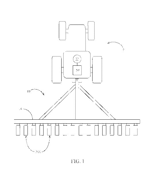
[0005] Figure 1 is a top view of an embodiment of an agricultural planter.
[0006] Figure 2 is a side elevation view of an embodiment of a planter row
unit.
[0007] Figure 3 schematically illustrates an embodiment of a soil monitoring
system.
CA 03123777 2021-06-16
WO 2020/161566 PCT/IB2020/050699
2
[0008] Figure 4A is a side elevation view of an embodiment of a seed firmer
having a plurality
of firmer-mounted sensors.
[0009] Figure 4B is a plan view of the seed firmer of Figure 4A.
[00010] Figure 4C is a rear elevation view of the seed firmer of Figure
4A.
[00011] Figure 5A illustrates another embodiment of the seed firmer 400" '
that
incorporates a fiber-optic cable 1900.
[00012] Figure 5B illustrates a seed firmer embodiment 400" having a fiber-
optic cable
extends to a spectrometer 373 configured to analyze light transmitted from the
soil.
[00013] Figure 6A is a front schematic view of a sensor with two emitters
and one
detector in line and an offset detector according to one embodiment.
[00014] Figure 6B is a side schematic view of the sensor of Figure 6A.
[00015] Figure 7 is a side view of a seed firmer and sensor arm according
to one
embodiment.
[00016] Figure 8 illustrates a flow diagram of one embodiment for a method
800 of
obtaining soil measurements and then calculating color values of the soil
based on the soil
measurements according to one embodiment.
[00017] Figure 9A illustrates an image that is generated based on
calculated color values
of the soil in accordance with one embodiment.
[00018] Figure 9B illustrates an image of calculated soil metrics (i.e.
Organic matter)
based on the measured reflectance of one or more wavelengths.
[00019] Figure 10 illustrates a calculated RGB values correlation in
accordance with one
embodiment.
[00020] Figure 11 shows an example of a system 1200 that includes a
machine 1202 (e.g.,
tractor, combine harvester, etc.) and an implement 1240 (e.g., planter,
sidedress bar, cultivator,
plough, sprayer, spreader, irrigation implement, etc.) in accordance with one
embodiment.
CA 03123777 2021-06-16
WO 2020/161566 PCT/IB2020/050699
3
BRIEF SUMMARY
[00021] Systems, apparatuses, and methods for agricultural monitoring of
soil
characteristics and determining soil color are described herein. In one
example, a method of
calculating soil color data includes obtaining, with sensors of a soil
apparatus, soil measurements
including at least one of measurements for moisture, organic matter, porosity,
type of soil, and
furrow residue. The method further includes calculating soil color values in a
visible spectrum
including at least one of red, green, and blue color values based on the soil
measurements and
determining color data for at least one color image without false image
artifacts based on the
calculated soil color values and associated coordinates within an agricultural
field. Currently,
satellite imagery can give some information regarding soil zones based on
observed soil color
variation; however, those images can be distorted due to lighting, topography,
shadows, weather,
season, vegetation coverage, etc.... The proposed method of capturing and
representing the true
soil color just below the surface is immune to most of the things that can
distort satellite or aerial
imagery. This will provide a true color image of the soil below the surface,
typically at planting
depth, un-distorted by the effects listed previously.
DETAILED DESCRIPTION
[00022] All references cited herein are incorporated herein in their
entireties. If there is a
conflict between a definition herein and in an incorporated reference, the
definition herein shall
control.
[00023] The terms trench and furrow are used interchangeably throughout
this
specification.
[00024] Depth Control and Soil Monitoring Systems
[00025] Referring now to the drawings, wherein like reference numerals
designate
identical or corresponding parts throughout the several views, Figure 1
illustrates a tractor 5
drawing an agricultural implement, e.g., a planter 10, comprising a toolbar 14
operatively
CA 03123777 2021-06-16
WO 2020/161566 PCT/IB2020/050699
4
supporting multiple row units 200. An implement monitor 50 preferably
including a central
processing unit ("CPU"), memory and graphical user interface ("GUI") (e.g., a
touch-screen
interface) is preferably located in the cab of the tractor 5. A global
positioning system ("GPS")
receiver 52 is preferably mounted to the tractor 5.
[00026] Turning to Figure 2, an embodiment is illustrated in which the row
unit 200 is a
planter row unit. The row unit 200 is preferably pivotally connected to the
toolbar 14 by a
parallel linkage 216. An actuator 218 is preferably disposed to apply lift
and/or downforce on
the row unit 200. A solenoid valve 390 is preferably in fluid communication
with the actuator
218 for modifying the lift and/or downforce applied by the actuator. An
opening system 234
preferably includes two opening discs 244 rollingly mounted to a downwardly-
extending shank
254 and disposed to open a v-shaped trench 38 in the soil 40. A pair of gauge
wheels 248 is
pivotally supported by a pair of corresponding gauge wheel arms 260; the
height of the gauge
wheels 248 relative to the opener discs 244 sets the depth of the trench 38. A
depth adjustment
rocker 268 limits the upward travel of the gauge wheel arms 260 and thus the
upward travel of
the gauge wheels 248. A depth adjustment actuator 380 is preferably configured
to modify a
position of the depth adjustment rocker 268 and thus the height of the gauge
wheels 248. The
actuator 380 is preferably a linear actuator mounted to the row unit 200 and
pivotally coupled to
an upper end of the rocker 268. In some embodiments the depth adjustment
actuator 380
comprises a device such as that disclosed in International Patent Application
No.
PCT/US2012/035585 ("the '585 application") or International Patent Application
Nos.
PCT/US2017/018269 or PCT/US2017/018274. An encoder 382 is preferably
configured to
generate a signal related to the linear extension of the actuator 380; it
should be appreciated that
the linear extension of the actuator 380 is related to the depth of the trench
38 when the gauge
wheel arms 260 are in contact with the rocker 268. A downforce sensor 392 is
preferably
configured to generate a signal related to the amount of force imposed by the
gauge wheels 248
on the soil 40; in some embodiments the downforce sensor 392 comprises an
instrumented pin
CA 03123777 2021-06-16
WO 2020/161566 PCT/IB2020/050699
about which the rocker 268 is pivotally coupled to the row unit 200, such as
those instrumented
pins disclosed in Applicant's U.S. Patent Application No. 12/522,253 (Pub. No.
US
2010/0180695).
[00027] Continuing to refer to Figure 2, a seed meter 230 such as that
disclosed in
Applicant's International Patent Application No. PCT/U52012/030192 is
preferably disposed to
deposit seeds 42 from a hopper 226 into the trench 38, e.g., through a seed
tube 232 disposed to
guide the seeds toward the trench. In some embodiments, instead of a seed tube
232, a seed
conveyor is implemented to convey seeds from the seed meter to the trench at a
controlled rate of
speed as disclosed in U.S. Patent Application Serial No. 14/347,902 and/or
U.S. Patent No.
8,789,482. In such embodiments, a bracket is preferably configured to mount
the seed firmer to
the shank via sidewalls extending laterally around the seed conveyor, such
that the seed firmer is
disposed behind the seed conveyor to firm seeds into the soil after they are
deposited by the seed
conveyor. In some embodiments, the meter is powered by an electric drive 315
configured to
drive a seed disc within the seed meter. In other embodiments, the drive 315
may comprise a
hydraulic drive configured to drive the seed disc. A seed sensor 305 (e.g., an
optical or
electromagnetic seed sensor configured to generate a signal indicating passage
of a seed) is
preferably mounted to the seed tube 232 and disposed to send light or
electromagnetic waves
across the path of seeds 42. A closing system 236 including one or more
closing wheels is
pivotally coupled to the row unit 200 and configured to close the trench 38.
[00028] Turning to Figure 3, a depth control and soil monitoring system
300 is
schematically illustrated. The monitor 50 is preferably in data communication
with components
associated with each row unit 200 including the drives 315, the seed sensors
305, the GPS
receiver 52, the downforce sensors 392, the valves 390, the depth adjustment
actuator 380, and
the depth actuator encoders 382. In some embodiments, particularly those in
which each seed
meter 230 is not driven by an individual drive 315, the monitor 50 is also
preferably in data
CA 03123777 2021-06-16
WO 2020/161566 PCT/IB2020/050699
6
communication with clutches 310 configured to selectively operably couple the
seed meter 230
to the drive 315.
[00029] Continuing to refer to Figure 3, the monitor 50 is preferably in
data
communication with a cellular modem 330 or other component configured to place
the monitor
50 in data communication with the Internet, indicated by reference numeral
335. The internet
connection may comprise a wireless connection or a cellular connection (e.g.,
LTE, 5G). Via the
Internet connection, the monitor 50 preferably receives data from a weather
data server 340 and
a soil data server 345. Via the Internet connection, the monitor 50 preferably
transmits
measurement data (e.g., measurements described herein) to a recommendation
server (which
may be the same server as the weather data server 340 and/or the soil data
server 345) for storage
and receives agronomic recommendations (e.g., planting recommendations such as
planting
depth, whether to plant, which fields to plant, which seed to plant, or which
crop to plant) from a
recommendation system stored on the server; in some embodiments, the
recommendation system
updates the planting recommendations based on the measurement data provided by
the monitor
50.
[00030] Continuing to refer to Figure 3, the monitor 50 is also preferably
in data
communication with one or more temperature sensors 360 mounted to the planter
10 and
configured to generate a signal related to the temperature of soil being
worked by the planter row
units 200. The monitor 50 is preferably in data communication with one or more
reflectivity
sensors 350 mounted to the planter 10 and configured to generate a signal
related to the
reflectivity of soil being worked by the planter row units 200.
[00031] Referring to Figure 3, the monitor 50 is preferably in data
communication with
one or more electrical conductivity sensors 365 mounted to the planter 10 and
configured to
generate a signal related to the temperature of soil being worked by the
planter row units 200.
[00032] In some embodiments, a first set of reflectivity sensors 350,
temperature sensors
360, and electrical conductivity sensors are mounted to a seed firmer 400 and
disposed to
CA 03123777 2021-06-16
WO 2020/161566 PCT/IB2020/050699
7
measure reflectivity, temperature and electrical conductivity, respectively,
of soil in the trench
38. In some embodiments, a second set of reflectivity sensors 350, temperature
sensors 360, and
electrical conductivity sensors 370 are mounted to a reference sensor assembly
1800 and
disposed to measure reflectivity, temperature and electrical conductivity,
respectively, of the soil,
preferably at a depth different than the sensors on the seed firmer 400.
[00033] In some embodiments, a subset of the sensors are in data
communication with the
monitor 50 via a bus 60 (e.g., a CAN bus). In some embodiments, the sensors
mounted to the
seed firmer 400 and the reference sensor assembly 1800 are likewise in data
communication with
the monitor 50 via the bus 60. However, in the embodiment illustrated in
Figure 3, the sensors
mounted to the seed firmer the sensors mounted to the seed firmer 400 and the
reference sensor
assembly 1800 are in data communication with the monitor 50 via a first
wireless transmitter 62-
1 and a second wireless transmitter 62-2, respectively. The wireless
transmitters 62 at each row
unit are preferably in data communication with a single wireless receiver 64
which is in turn in
data communication with the monitor 50. The wireless receiver may be mounted
to the toolbar
14 or in the cab of the tractor 5.
[00034] Soil Monitoring, Seed Monitoring and Seed Firming Apparatus
[00035] Turning to Figures 4A-4C, an embodiment of a seed firmer 400 is
illustrated
having a plurality of sensors for sensing soil characteristics. The seed
firmer 400 preferably
includes a flexible portion 410 mounted to the shank 254 and/or the seed tube
232 by a bracket
415. In some embodiments, the bracket 415 is similar to one of the bracket
embodiments
disclosed in U.S. Patent No. 6,918,342. The seed firmer preferably includes a
firmer body 490
disposed and configured to be received at least partially within v-shaped
trench 38 and firm
seeds 42 into the bottom of the trench. When the seed firmer 400 is lowered
into the trench 38,
the flexible portion 410 preferably urges the firmer body 490 into resilient
engagement with the
trench. In some embodiments the flexible portion 410 preferably includes an
external or internal
reinforcement as disclosed in PCT/U52013/066652. In some embodiments the
firmer body 490
CA 03123777 2021-06-16
WO 2020/161566 PCT/IB2020/050699
8
includes a removable portion 492; the removable portion 492 preferably slides
into locking
engagement with the remainder of the firmer body. The firmer body 490
(preferably including
the portion of the firmer body engaging the soil, which in some embodiments
comprises the
removable portion 492) is preferably made of a material (or has an outer
surface or coating)
having hydrophobic and/or anti-stick properties, e.g. having a Teflon graphite
coating and/or
comprising a polymer having a hydrophobic material (e.g., silicone oil or
polyether-ether-
ketone) impregnated therein. Alternatively, the sensors can be disposed on the
side of seed
firmer 400 (not shown).
[00036] Returning to Figures 4A through 4C, the seed firmer 400 preferably
includes a
plurality of reflectivity sensors 350a, 350b. Each reflectivity sensor 350 is
preferably disposed
and configured to measure reflectivity of soil; in a preferred embodiment, the
reflectivity sensor
350 is disposed to measure soil in the trench 38, and preferably at the bottom
of the trench. The
reflectivity sensor 350 preferably includes a lens disposed in the bottom of
the firmer body 490
and disposed to engage the soil at the bottom of the trench 38. In some
embodiments the
reflectivity sensor 350 comprises one of the embodiments disclosed in
8,204,689 and/or U.S.
Provisional Patent Application 61/824975 ("the '975 application"). In various
embodiments, the
reflectivity sensor 350 is configured to measure reflectivity in the visible
range (e.g., 400, 460,
520, 589, and/or 600 nanometers), in the near-infrared range (e.g., 850, 940
nanometers) and/or
elsewhere the infrared range.
[00037] The seed firmer 400 may also include a capacitive moisture sensor
351 disposed
and configured to measure capacitance moisture of the soil in the seed trench
38, and preferably
at the bottom of trench 38.
[00038] The seed firmer 400 may also include an electronic tensiometer
sensor 352
disposed and configured to measure soil moisture tension of the soil in the
seed trench 38, and
preferably at the bottom of trench 38.
CA 03123777 2021-06-16
WO 2020/161566 PCT/IB2020/050699
9
[00039] Alternatively, soil moisture tension can be extrapolated from
capacitive moisture
measurements or from reflectivity measurements (such as at 1450 nm). This can
be done using a
soil water characteristic curve based on the soil type.
[00040] The seed firmer 400 may also include a temperature sensor 360. The
temperature
sensor 360 is preferably disposed and configured to measure temperature of
soil; in a preferred
embodiment, the temperature sensor is disposed to measure soil in the trench
38, preferably at or
adjacent the bottom of the trench 38. The temperature sensor 360 preferably
includes soil-
engaging ears 364, 366 disposed to slidingly engage each side of the trench 38
as the planter
traverses the field. The ears 364, 366 preferably engage the trench 38 at or
adjacent to the
bottom of the trench. The ears 364, 366 are preferably made of a thermally
conductive material
such as copper. The ears 364 are preferably fixed to and in thermal
communication with a
central portion 362 housed within the firmer body 490. The central portion 362
preferably
comprises a thermally conductive material such as copper; in some embodiments
the central
portion 362 comprises a hollow copper rod. The central portion 362 is
preferably in thermal
communication with a thermocouple fixed to the central portion. In other
embodiments, the
temperature sensor 360 may comprise a non-contact temperature sensor such as
an infrared
thermometer. In some embodiments, other measurements made by the system 300
(e.g.,
reflectivity measurements, electrical conductivity measurements, and/or
measurements derived
from those measurements) are temperature-compensated using the temperature
measurement
made by the temperature sensor 360. The adjustment of the temperature-
compensated
measurement based on temperature is preferably carried out by consulting an
empirical look-up
table relating the temperature-compensated measurement to soil temperature.
For example, the
reflectivity measurement at a near-infrared wavelength may be increased (or in
some examples,
reduced) by 1% for every 1 degree Celsius in soil temperature above 10 degrees
Celsius.
[00041] The seed firmer preferably includes a plurality of electrical
conductivity sensors
370r, 370f. Each electrical conductivity sensor 370 is preferably disposed and
configured to
CA 03123777 2021-06-16
WO 2020/161566 PCT/IB2020/050699
measure electrical conductivity of soil; in a preferred embodiment, the
electrical conductivity
sensor is disposed to measure electrical conductivity of soil in the trench
38, preferably at or
adjacent the bottom of the trench 38. The electrical conductivity sensor 370
preferably includes
soil-engaging ears 374, 376 disposed to slidingly engage each side of the
trench 38 as the planter
traverses the field. The ears 374, 376 preferably engage the trench 38 at or
adjacent to the
bottom of the trench. The ears 374, 376 are preferably made of an electrically
conductive
material such as copper. The ears 374 are preferably fixed to and in
electrical communication
with a central portion 372 housed within the firmer body 490. The central
portion 372 preferably
comprises an electrically conductive material such as copper; in some
embodiments the central
portion 372 comprises a copper rod. The central portion 372 is preferably in
electrical
communication with an electrical lead fixed to the central portion. The
electrical conductivity
sensor can measure the electrical conductivity within a trench by measuring
the electrical current
between soil-engaging ears 374 and 376.
[00042] Referring to Figure 4B, in some embodiments the system 300
measures electrical
conductivity of soil adjacent the trench 38 by measuring an electrical
potential between the
forward electrical conductivity sensor 370f and the rearward electrical
conductivity sensor 370f.
In other embodiments, the electrical conductivity sensors 370f, 370r may be
disposed in
longitudinally spaced relation on the bottom of the seed firmer in order to
measure electrical
conductivity at the bottom of the seed trench.
[00043] In other embodiments, the electrical conductivity sensors 370
comprise one or
more ground-working or ground-contacting devices (e.g., discs or shanks) that
contact the soil
and are preferably electrically isolated from one another or from another
voltage reference. The
voltage potential between the sensors 370 or other voltage reference is
preferably measured by
the system 300. The voltage potential or another electrical conductivity value
derived from the
voltage potential is preferably and reported to the operator. The electrical
conductivity value
may also be associated with the GPS-reported position and used to generate a
map of the spatial
CA 03123777 2021-06-16
WO 2020/161566 PCT/IB2020/050699
11
variation in electrical conductivity throughout the field. In some such
embodiments, the
electrical conductivity sensors may comprise one or more opening discs of a
planter row unit,
row cleaner wheels of a planter row unit, ground-contacting shanks of a
planter, ground-
contacting shoes depending from a planter shank, shanks of a tillage tool, or
discs of a tillage
tool. In some embodiments a first electrical conductivity sensor may comprise
a component
(e.g., disc or shank) of a first agricultural row unit while a second
electrical conductivity sensor
comprises a component (e.g., disc or shank) of a second agricultural row unit,
such that electrical
conductivity of soil extending transversely between the first and second row
units is measured.
It should be appreciated that at least one of the electrical conductivity
sensors described herein is
preferably electrically isolated from the other sensor or voltage reference.
In one example, the
electrical conductivity sensor is mounted to an implement (e.g., to the
planter row unit or tillage
tool) by being first mounted to an electrically insulating component (e.g., a
component made
from an electrically insulating material such as polyethylene, polyvinyl
chloride, or a rubber-like
polymer) which is in turn mounted to the implement.
[00044] Referring to Figure 4C, in some embodiments the system 300
measures electrical
conductivity of soil between two row units 200 having a first seed firmer 400-
1 and a second
seed firmer 400-2, respectively, by measuring an electrical potential between
an electrical
conductivity sensor on the first seed firmer 400-1 and an electrical
conductivity sensor on the
second seed firmer 400-2. In some such embodiments, the electrical
conductivity sensor 370
may comprise a larger ground-engaging electrode (e.g., a seed firmer housing)
comprised of
metal or other conductive material. It should be appreciated that any of the
electrical
conductivity sensors described herein may measure conductivity by any of the
following
combinations: (1) between a first probe on a ground-engaging row unit
component (e.g., on a
seed firmer, a row cleaner wheel, an opening disc, a shoe, a shank, a frog, a
coulter, or a closing
wheel) and a second probe on the same ground-engaging row unit component of
the same row
unit; (2) between a first probe on a first ground-engaging row unit component
(e.g., on a seed
CA 03123777 2021-06-16
WO 2020/161566 PCT/IB2020/050699
12
firmer, a row cleaner wheel, an opening disc, a shoe, a shank, a frog, a
coulter, or a closing
wheel) and a second probe on a second ground-engaging row unit component
(e.g., on a seed
firmer, a row cleaner wheel, an opening disc, a shoe, a shank, a frog, a
coulter, or a closing
wheel) of the same row unit; or (3) between a first probe on a first ground-
engaging row unit
component (e.g., on a seed firmer, a row cleaner wheel, an opening disc, a
shoe, a shank, a frog,
a coulter, or a closing wheel) on a first row unit and a second probe on a
second ground-
engaging row unit component (e.g., on a seed firmer, a row cleaner wheel, an
opening disc, a
shoe, a shank, a frog, a coulter, or a closing wheel) on a second row unit.
Either or both of the
row units described in combinations 1 through 3 above may comprise a planting
row unit or
another row unit (e.g., a tillage row unit or a dedicated measurement row
unit) which may be
mounted forward or rearward of the toolbar.
[00045] The reflectivity sensors 350, the temperature sensors 360, 360',
360", and the
electrical conductivity sensors 370 (collectively, the "firmer-mounted
sensors") are preferably in
data communication with the monitor 50. In some embodiments, the firmer-
mounted sensors are
in data communication with the monitor 50 via a transceiver (e.g., a CAN
transceiver) and the
bus 60. In other embodiments, the firmer-mounted sensors are in data
communication with the
monitor 50 via wireless transmitter 62-1 (preferably mounted to the seed
firmer) and wireless
receiver 64. In some embodiments, the firmer-mounted sensors are in electrical
communication
with the wireless transmitter 62-1 (or the transceiver) via a multi-pin
connector comprising a
male coupler 472 and a female coupler 474. In firmer body embodiments having a
removable
portion 492, the male coupler 472 is preferably mounted to the removable
portion and the female
coupler 474 is preferably mounted to the remainder of the firmer body 190; the
couplers 472,
474 are preferably disposed such that the couplers engage electrically as the
removable portion is
slidingly mounted to the firmer body.
[00046] Turning to Figure 5A, another embodiment of the seed firmer 400" '
is illustrated
incorporating a fiber-optic cable 1900. The fiber-optic cable 1900 preferably
terminates at a lens
CA 03123777 2021-06-16
WO 2020/161566 PCT/IB2020/050699
13
1902 in the bottom of the firmer 400". The fiber-optic cable 1900 preferably
extends to a
reflectivity sensor 350a, which is preferably mounted separately from the seed
firmer, e.g.,
elsewhere on the row unit 200. In operation, light reflected from the soil
(preferably the bottom
of trench 28) travels to the reflectivity sensor 350a via the fiber-optic
cable 1900 such that the
reflectivity sensor 350a is enabled to measure reflectivity of the soil at a
location remote from
the seed firmer 400". In other embodiments such as the seed firmer embodiment
400"
illustrated in Figure 5B, the fiber-optic cable extends to a spectrometer 373
configured to analyze
light transmitted from the soil. The spectrometer 373 is preferably configured
to analyze
reflectivity at a spectrum of wavelengths. The spectrometer 373 is preferably
in data
communication with the monitor 50. The spectrometer 373 preferably comprises a
fiber-optic
spectrometer such as model no. USB4000 available from Ocean Optics, Inc. in
Dunedin,
Florida. In the embodiments 400' and 400', a modified firmer bracket 415' is
preferably
configured to secure the fiber-optic cable 1900.
[00047] In certain embodiments, the wavelength used in reflectivity sensor
350 is in a
range of 400 to 1600 nm. In another embodiment, the wavelength is 550 to 1450
nm. In one
embodiment, there is a combination of wavelengths. In one embodiment, sensor
350 has a
combination of 574 nm, 850 nm, 940 nm, and 1450nm. In another embodiment,
sensor 350 has
a combination of 589nm, 850 nm, 940 nm, and 1450nm. In another embodiment,
sensor 350 has
a combination of 640 nm, 850 nm, 940 nm, and 1450nm. In another embodiment,
the 850 nm
wavelength in any of the previous embodiments is replaced with 1200 nm. In
another
embodiment, the 574 nm wavelength of any of the previous embodiments is
replaced with 590
nm. For each of the wavelengths described herein, it is to be understood that
the number is
actually +/- 10 nm of the listed value. In certain embodiments, the
combination of wavelengths
is 460 nm, 589 nm, 850 nm, 1200 nm, and 1450 nm is used.
[00048] In one embodiment, the field of view from the front 402-f of lens
402' to the soil
surface is 0 to 7.5 mm (0 to 0.3 inches). In another embodiment, the field of
view is 0 to 6.25
CA 03123777 2021-06-16
WO 2020/161566 PCT/IB2020/050699
14
mm (0 to 0.25 inches). In another embodiment, the field of view is 0 to 5 mm
(0 to 0.2 inches).
In another embodiment, the field of is 0 to 2.5 mm (0 to 0.1 inches).
[00049] As seed firmer 400' travels across trench 38, there may be
instances where there
is a gap between trench 38 and seed firmer 400' such that ambient light will
be detected by
reflectivity sensor 350. This will give a falsely high result. In one
embodiment to remove the
signal increase from ambient light, emitter 350-e can be pulsed on and off The
background
signal is measured when there is no signal from emitter 350-e. The measured
reflectivity is then
determined by subtracting the background signal from the raw signal when
emitter 350-e is
emitting to provide the actual amount of reflectivity.
[00050] In another embodiment as illustrated in Figures 6A and 6B, there
is a reflectivity
sensor 350 that has two emitters 350-e-1 and 350-e-2 in line with a detector
350-d-1. As viewed
the emitters 350-e-1 and 350-e-2 are pointed out of the paper, and the view of
detector 350-d-1 is
pointed out of the paper. There is a second detector that is offset from
emitters 350-e-1 and 350-
e-2 and detector 350-d-1. In another embodiment (not shown) emitter 350-e-2 is
omitted. As
seen in Figure 6B, detector 350-d-2 is angled from vertical by an angle a and
is viewing towards
emitters 350-e-1 and 350-e-2 and detector 350-d-1, which are aligned into the
paper. In one
embodiment, the angle a is 30 to 60 . In another embodiment, the angle a is 45
. In one
embodiment, the wavelength of light used in this arrangement is 940 nm. This
arrangement
allows for measurement of void spaces in soil. Detecting void spaces in soil
will inform how
effective tillage has been. The less or smaller void spaces indicates more
compaction and less
effective tillage. More or larger void spaces indicates better tillage. Having
this measurement of
tillage effectiveness allows for adjustment of downforce on row unit 200 as
described herein.
[00051] Residue coverage and soil color can be obtained from imagery.
Imagery can be
obtained from a satellite or an aircraft, such as a drone, or from a camera
disposed over the field,
such as on a pole. For user input of seed shape/size or cold germ, a user can
input this
information directly, a user can scan a code (bar code or QR code from a
package), or a user can
CA 03123777 2021-06-16
WO 2020/161566 PCT/IB2020/050699
input the specific type of seed (or scan a code), and then the size, shape,
and cold germ can be
referenced from a database based on the seed type. The reference source for
topography can be
from stored information, such as a map, that was previously measured. Any
method of
measuring topography can be used. As an alternative to adjusting depth,
downforce can be
adjusted to effect a change in depth, or row cleaner aggressiveness can be
changed.
[00052] In another embodiment, any of the previous embodiments can be in a
device
separate from seed firmer 400, 400'. As illustrated in Figure 7, any of the
sensors described
herein (sensor 350 is illustrated in the Figure 7) is disposed in sensor arm
5000. Sensor arm
5000 has flexible portion 5001 that is attached to seed firmer 400" ' at an
end of flexible portion
410" of seed firmer 400" ' proximate to bracket insert portion 411". At the
opposite end of
flexible portion 5001 is base 5002. Sensor 350 is disposed in base 5002 behind
lens 5003.
While it is desirable for any of the sensors to be in seed firmer 400", there
may be times when a
difference in the applied force is needed. In one embodiment, seed firmer 400"
' may need a
lower amount of force to firm a seed but a greater force is needed to keep the
sensor in soil
contact. A different amount of stiffness can be designed into flexible portion
5001 as compared
to flexible portion 410". By having the seed firmed by seed firmer 400, 400'
first, then the
biasing from sensor arm 5000 does not touch the seed that is already firmed
into trench 38 or
does not move the seed if contact is made.
[00053] In other embodiments, any of the sensors do not need to be
disposed in a firmer.
The sensors can be in any implement that is disposed on an agricultural
implement in contact
with the soil. For example, firmer body 490 can be mounted to any bracket and
disposed
anywhere on an agricultural implement and in contact with soil. Examples of an
agricultural
implement include, but are not limited to, planters, harvesters, sprayers,
side dress bars, tillers,
fertilizer spreaders, and tractor.
[00054] Figure 8 illustrates a flow diagram of one embodiment for a method
800 of
obtaining soil measurements and then calculating color values of the soil
based on the soil
CA 03123777 2021-06-16
WO 2020/161566 PCT/IB2020/050699
16
measurements according to one embodiment. The method 800 is performed by
hardware
(circuitry, dedicated logic, etc.), software (such as is run on a general
purpose computer system
or a dedicated machine or a device), or a combination of both. In one
embodiment, the method
800 is performed by at least one system or device (e.g., monitor 50, soil
monitoring system, seed
firmer, sensors, implement, row unit, etc). The system or device can be local
with respect to the
measuring of the soil measurements or remotely located (e.g., cloud based
system or device)
with respect to the measuring of the soil measurements. The system executes
instructions of a
software application or program with processing logic. The software
application or program can
be initiated by a system or may notify an operator or user of a machine (e.g.,
tractor, planter,
combine) depending on whether soil measurements cause a signal to actuate an
implement.
[00055] In any embodiment herein, at operation 802, a system or device
(e.g., soil
monitoring system, monitor 50, seed firmer, sensors) can obtain soil
measurements (e.g.,
measurements for moisture, organic matter, soil color, porosity, texture/type
of soil, furrow
residue, etc.).
[00056] At operation 804, the system or device determines or calculates
soil color values
in a visible spectrum (e.g., red (620 nm), green (520 nm), blue (450 nm))
based on the soil
measurements from at least one other non-RGB wavelength (e.g., 460 nm, 589 nm,
850 nm). In
one example, blue values are calculated based on the 460 nm wavelength. Green
values are
calculated based on the 460 nm wavelength and 589 nm wavelength for yellow.
Red values are
calculated based on the 460 nm wavelength, the 589 nm wavelength for yellow,
and the 850 nm
wavelength for IRA. In this example, red, green, and blue wavelengths are not
measured by a
soil device or apparatus. Rather, emitters and detectors for other wavelengths
measure soil
characteristics (e.g., measurements for moisture, organic matter, porosity,
texture/type of soil,
furrow residue, etc.) during an agricultural input and measurements for these
other wavelengths
are used to calculate red, green, and blue values for the soil. The soil
device or apparatus does
CA 03123777 2021-06-16
WO 2020/161566 PCT/IB2020/050699
17
not need red, green, and blue sensors with emitters and detectors. In a
specific example, the
selected wavelengths of the soil device or apparatus measure moisture and
organic matter.
[00057] At operation 806, the system or device determines colors for a
given coordinate
within an agricultural field based on the determined or calculated color
values from operation
804.
[00058] At operation 808, the system or device determines color data for
at least one color
image based on the colors and coordinates (e.g., GPS coordinates) within an
agricultural field.
[00059] At operation 810, the system or device presents the at least one
color image on a
display device or monitor without any false image artifacts.
[00060] At operation 812, the system or device (e.g., soil monitoring
system, monitor 50)
can optionally generate a signal to actuate any implement on any agricultural
implement (e.g.,
change a population of planted seeds by controlling a seed meter, change seed
variety (e.g.,
hybrid), change furrow depth, change application rate of fertilizer,
fungicide, and/or insecticide,
change applied downforce or upforce of an agricultural implement, such as a
planter or tiller,
control the force applied by a row cleaner) in response to obtaining soil
measurements. This can
be done in real time on the go.
[00061] Examples of soil measurements that can be measured and the control
of
implements include, but are not limited to:
A) moisture, organic matter, porosity, or texture/type of soil to change a
population of
planted seeds by controlling a seed meter;
B) moisture, organic matter, porosity, or texture/type of soil to change
seed variety (e.g.,
hybrid);
C) moisture, organic matter, porosity, or texture/type of soil to change
furrow depth:
D) moisture, organic matter, porosity, or texture/type of soil to change
application rate of
fertilizer, fungicide, and/or insecticide;
E) moisture, organic matter, porosity, or texture/type of soil to change
applied downforce or
CA 03123777 2021-06-16
WO 2020/161566 PCT/IB2020/050699
18
upforce of an agricultural implement, such as a planter or tiller;
F) furrow residue to control the force applied by a row cleaner.
In one embodiment for downforce or upforce, a combination of moisture and
texture/type can be
used. Higher downforce can be applied in sandy and/or wet soils, and lower
downforce can be
used in clay and/or wet soils. Too much downforce for a given soil type can
cause compaction
of the soil, which decreases the ability of roots to spread throughout the
soil. Too little
downforce for a given soil type can allow an implement to ride up and not
plant seeds to a
targeted depth. The downforce is generally applied through the gauge wheels
248 adjacent to the
trench.
[00062] Figure 9B illustrates a color image that is generated based on
calculated color
values of the soil in accordance with one embodiment. The visible spectrum
color values are
added onto a field that is illustrated in Figure 9A based on coordinates for
respective color
values. The color values are calculated based on measurements of reflective
sensors at planting
depth of soil. The color images generated can be a supplement for satellite
images, but looking
just under the surface of soil within a field. Additionally, the color images
are generated from a
sequence of subsurface soil color measurements, without any false image
artifacts typically
associated with satellite soil imagery such as topograpy, cover vegetation,
shadows, lighting
conditions, weather conditions, etc.
[00063] In one example, RGB values are obtained from an agricultural soil
device or
apparatus (e.g., smart seed firmer) having sensors for emitting and detecting
460 nm, 589 nm,
and 850 nm wavelengths. Coefficients can be determined empirically from values
in a soil
library or database with 99+% R2 fit of actual RGB values as illustrated in
Figure 10. Red,
green, and blue values can be determined from reflectance sensors of a soil
apparatus (e.g., smart
seed firmer) as follows for one example.
[00064] True Color Red = soil apparatus 460nm reflectance * (-0.209) +
soil apparatus
589nm reflectance * 1.06 + soil apparatus 850nm reflectance * 0.113
CA 03123777 2021-06-16
WO 2020/161566 PCT/IB2020/050699
19
[00065] True Color Green = soil apparatus 460nm reflectance * 0.789 +soil
apparatus
589nm reflectance * 0.305
[00066] True Color Blue = soil apparatus 460nm reflectance
[00067] Any data that is measured during a pass through the field can be
stored in a geo-
referenced map and used again during a later pass in the same field during the
same season or in
a subsequent year. For example, organic matter can be measured during a
planting pass through
the field during planting. Having the geo-referenced organic matter content
can be used during a
fertilization pass to variable rate fertilizer based on location specific
organic matter content. The
data collected can be stored in a separate data file or as part of the field
file.
[00068] Figure 11 shows an example of a system 1200 that includes a
machine 1202 (e.g.,
tractor, combine harvester, etc.) and an implement 1240 (e.g., planter,
sidedress bar, cultivator,
plough, sprayer, spreader, irrigation implement, etc.) in accordance with one
embodiment. The
machine 1202 includes a processing system 1220, memory 1205, machine network
1210 (e.g., a
controller area network (CAN) serial bus protocol network, an ISOBUS network,
etc.), and a
network interface 1215 for communicating with other systems or devices
including the
implement 1240. The machine network 1210 includes sensors 1212 (e.g., speed
sensors),
controllers 1211 (e.g., GPS receiver, radar unit) for controlling and
monitoring operations of the
machine or implement. The network interface 1215 can include at least one of a
GPS transceiver,
a WLAN transceiver (e.g., WiFi), an infrared transceiver, a Bluetooth
transceiver, Ethernet, or
other interfaces from communications with other devices and systems including
the implement
1240. The network interface 1215 may be integrated with the machine network
1210 or separate
from the machine network 1210 as illustrated in Figure 12. The I/0 ports 1229
(e.g.,
diagnostic/on board diagnostic (OBD) port) enable communication with another
data processing
system or device (e.g., display devices, sensors, etc.).
[00069] In one example, the machine performs operations of a tractor that
is coupled to an
implement for planting applications of a field. The planting data for each row
unit of the
CA 03123777 2021-06-16
WO 2020/161566 PCT/IB2020/050699
implement can be associated with locational data at time of application to
have a better
understanding of the planting for each row and region of a field. Data
associated with the
planting applications can be displayed on at least one of the display devices
1225 and 1230. The
display devices can be integrated with other components (e.g., processing
system 1220, memory
1205, etc.) to form the monitor 50.
[00070] The processing system 1220 may include one or more
microprocessors,
processors, a system on a chip (integrated circuit), or one or more
microcontrollers. The
processing system includes processing logic 1226 for executing software
instructions of one or
more programs and a communication unit 1228 (e.g., transmitter, transceiver)
for transmitting
and receiving communications from the machine via machine network 1210 or
network interface
1215 or implement via implement network 1250 or network interface 1260. The
communication
unit 1228 may be integrated with the processing system or separate from the
processing system.
In one embodiment, the communication unit 1228 is in data communication with
the machine
network 1210 and implement network 1250 via a diagnostic/OBD port of the I/0
ports 1229.
[00071] Processing logic 1226 including one or more processors or
processing units may
process the communications received from the communication unit 1228 including
agricultural
data (e.g., GPS data, planting application data, soil characteristics, any
data sensed from sensors
of the implement 1240 and machine 1202, etc.). The processing logic 1226 can
process soil
measurements to determine soil color values. The system 1200 includes memory
1205 for
storing data and programs for execution (software 1206) by the processing
system. The memory
1205 can store, for example, software components such as planting application
software for
analysis of soil and planting applications for performing operations of the
present disclosure, or
any other software application or module, images (e.g., captured images of
crops, soil, furrow,
soil clods, row units, etc.), alerts, maps, etc. The memory 1205 can be any
known form of a
machine readable non-transitory storage medium, such as semiconductor memory
(e.g., flash;
SRAM; DRAM; etc.) or non-volatile memory, such as hard disks or solid-state
drive. The system
CA 03123777 2021-06-16
WO 2020/161566 PCT/IB2020/050699
21
can also include an audio input/output subsystem (not shown) which may include
a microphone
and a speaker for, for example, receiving and sending voice commands or for
user authentication
or authorization (e.g., biometrics).
[00072] The processing system 1220 communicates bi-directionally with
memory 1205,
machine network 1210, network interface 1215, header 1280, display device
1230, display
device 1225, and I/0 ports 1229 via communication links 1231-1236,
respectively. The
processing system 1220 can be integrated with the memory 1205 or separate from
the memory
1205.
[00073] Display devices 1225 and 1230 can provide visual user interfaces
for a user or
operator. The display devices may include display controllers. In one
embodiment, the display
device 1225 is a portable tablet device or computing device with a touchscreen
that displays data
(e.g., planting application data, captured images, localized view map layer,
soil color data and
images, high definition field maps of seed germination data, seed environment
data, as-planted
or as-harvested data or other agricultural variables or parameters, yield
maps, alerts, etc.) and
data generated by an agricultural data analysis software application and
receives input from the
user or operator for an exploded view of a region of a field, monitoring and
controlling field
operations. The operations may include configuration of the machine or
implement, reporting of
data, control of the machine or implement including sensors and controllers,
and storage of the
data generated. The display device 1230 may be a display (e.g., display
provided by an original
equipment manufacturer (OEM)) that displays images and data for a localized
view map layer,
as-applied fluid application data, as-planted or as-harvested data, yield
data, seed germination
data, seed environment data, controlling a machine (e.g., planter, tractor,
combine, sprayer, etc.),
steering the machine, and monitoring the machine or an implement (e.g.,
planter, combine,
sprayer, etc.) that is connected to the machine with sensors and controllers
located on the
machine or implement.
CA 03123777 2021-06-16
WO 2020/161566 PCT/IB2020/050699
22
[00074] A cab control module 1270 may include an additional control module
for
enabling or disabling certain components or devices of the machine or
implement. For example,
if the user or operator is not able to control the machine or implement using
one or more of the
display devices, then the cab control module may include switches to shut down
or turn off
components or devices of the machine or implement.
[00075] The implement 1240 (e.g., planter, cultivator, plough, sprayer,
spreader, irrigation
implement, etc.) includes an implement network 1250, a processing system 1262,
a network
interface 1260, and optional input/output ports 1266 for communicating with
other systems or
devices including the machine 1202. The implement network 1250 (e.g, a
controller area
network (CAN) serial bus protocol network, an ISOBUS network, etc.) includes a
pump 1256 for
pumping fluid from a storage tank(s) 1290 to application units 1280, 1281,
...N of the
implement, sensors 1252 (e.g., speed sensors, seed sensors for detecting
passage of seed, sensors
for detecting characteristics of soil or a trench including soil moisture,
soil organic matter, soil
temperature, soil color, seed presence, seed spacing, percentage of seeds
firmed, and soil residue
presence, downforce sensors, actuator valves, moisture sensors or flow sensors
for a combine,
speed sensors for the machine, seed force sensors for a planter, fluid
application sensors for a
sprayer, or vacuum, lift, lower sensors for an implement, flow sensors, etc.),
controllers 1254
(e.g., GPS receiver), and the processing system 1262 for controlling and
monitoring operations
of the implement. The pump controls and monitors the application of the fluid
to crops or soil as
applied by the implement. The fluid application can be applied at any stage of
crop development
including within a planting trench upon planting of seeds, adjacent to a
planting trench in a
separate trench, or in a region that is nearby to the planting region (e.g.,
between rows of corn or
soybeans) having seeds or crop growth.
[00076] For example, the controllers may include processors in
communication with a
plurality of seed sensors. The processors are configured to process data
(e.g., fluid application
data, seed sensor data, soil data, furrow or trench data) and transmit
processed data to the
CA 03123777 2021-06-16
WO 2020/161566 PCT/IB2020/050699
23
processing system 1262 or 1220. The controllers and sensors may be used for
monitoring
motors and drives on a planter including a variable rate drive system for
changing plant
populations. The controllers and sensors may also provide swath control to
shut off individual
rows or sections of the planter. The sensors and controllers may sense changes
in an electric
motor that controls each row of a planter individually. These sensors and
controllers may sense
seed delivery speeds in a seed tube for each row of a planter.
[00077] The network interface 1260 can be a GPS transceiver, a WLAN
transceiver (e.g.,
WiFi), an infrared transceiver, a Bluetooth transceiver, Ethernet, or other
interfaces from
communications with other devices and systems including the machine 1202. The
network
interface 1260 may be integrated with the implement network 1250 or separate
from the
implement network 1250 as illustrated in Figure 12.
[00078] The processing system 1262 communicates bi-directionally with the
implement
network 1250, network interface 1260, and 1/0 ports 1266 via communication
links 1241-1243,
respectively.
[00079] The implement communicates with the machine via wired and possibly
also
wireless bi-directional communications 1204. The implement network 1250 may
communicate
directly with the machine network 1210 or via the networks interfaces 1215 and
1260. The
implement may also by physically coupled to the machine for agricultural
operations (e.g.,
planting, harvesting, spraying, etc.).
[00080] The memory 1205 may be a machine-accessible non-transitory medium
on which
is stored one or more sets of instructions (e.g., software 1206) embodying any
one or more of the
methodologies or functions described herein. The software 1206 may also
reside, completely or
at least partially, within the memory 1205 and/or within the processing system
1220 during
execution thereof by the system 1200, the memory and the processing system
also constituting
machine-accessible storage media. The software 1206 may further be transmitted
or received
over a network via the network interface 1215.
CA 03123777 2021-06-16
WO 2020/161566 PCT/IB2020/050699
24
[00081] In one embodiment, a machine-accessible non-transitory medium
(e.g., memory
1205) contains executable computer program instructions which when executed by
a data
processing system cause the system to performs operations or methods of the
present disclosure.
While the machine-accessible non-transitory medium (e.g., memory 1205) is
shown in an
exemplary embodiment to be a single medium, the term "machine-accessible non-
transitory
medium" should be taken to include a single medium or multiple media (e.g., a
centralized or
distributed database, and/or associated caches and servers) that store the one
or more sets of
instructions. The term "machine-accessible non-transitory medium" shall also
be taken to
include any medium that is capable of storing, encoding or carrying a set of
instructions for
execution by the machine and that cause the machine to perform any one or more
of the
methodologies of the present disclosure. The term "machine-accessible non-
transitory medium"
shall accordingly be taken to include, but not be limited to, solid-state
memories, optical and
magnetic media, and carrier wave signals.
[00082] Any of the following examples can be combined into a single
embodiment or
these examples can be separate embodiments. In one example of a first
embodiment, a method of
calculating soil color data includes obtaining, with sensors of a soil
apparatus, soil measurements
including at least one of measurements for moisture, organic matter, porosity,
type of soil, and
furrow residue. The method further includes calculating soil color values in a
visible spectrum
including at least one of red, green, and blue color values based on the soil
measurements and
determining color data for at least one color image without false image
artifacts based on the
calculated soil color values and associated coordinates within an agricultural
field.