Note: Descriptions are shown in the official language in which they were submitted.
CA 03125658 2021-07-05
Attorney Docket No.: CA127
Patent Application
AUTOMATIC DRIVING SYSTEM FOR GRAIN PROCESSING,
AUTOMATIC DRIVING METHOD, AND PATH PLANNING METHOD
FIELD
[0001] The present disclosure relates to agriculture, an autonomous
driving field of
agricultural machinery, and especially relates to an automatic driving system
for grain
processing, and an automatic driving method and a path planning method.
BACKGROUND
[0002] Agricultural machinery refers to various machinery used in the
initial processing
process of agricultural products and animal products, as well as in the
production of crops and
animal husbandry. The types of the agricultural machinery are various, such as
seeding
equipment, plowing equipment, harrowing equipment, rotary tillers, plant
protection
equipment, harvesting equipment, and so on. In the operation process, the
agricultural
machinery needs to take into account of a walking system and an operation
system of the
mechanical equipment. When the agricultural machinery is in motion in the
farmland, it is
necessary to adjust a route of the agricultural machinery according to
conditions of the
farmland.
[0003] When the agricultural machinery is operating in farmland, it is
necessary to judge
the condition of the farmland and the crop growth of the farmland in real
time, and to operate
agricultural machinery and the operation system according to the operation
condition of the
1
Date Recue/Date Received 2021-07-05
CA 03125658 2021-07-05
Attorney Docket No.: CA127
Patent Application
farmland and the crop growth of the farmland. In the prior art, operating the
operation of the
agricultural machinery and the operation system can be done by human drivers
and operators.
The agricultural machinery needs to take into account worked area of the
farmland, unworked
area of the farmland, as well as boundaries and many other factors. In the
operation process of
the agricultural machinery, an operation of a vehicle and operation parameters
needs to be
adjusted in real time according to the condition of the crop. As a complex
operating
environment needs to be considered during driving, the agricultural equipment
of the existing
technology also requires the operator to adjust the operation of the
agricultural machinery
based on real-time information of the farmland crop. The probability of
judgmental error in the
operation of agricultural machinery is greater when manual operation is
employed, which
leads to increase in failure probability of the mechanical equipment in the
course of operation.
[0004] Existing agricultural machinery is not smart, and it is not
possible to get rid of the
driver of the agricultural equipment. Based on the PTK satellite positioning
method, a
high-precision satellite positioning information can be obtained, but for self-
driving
agricultural machinery, especially harvester equipment, in the operation, it
is more important
to determine a harvested area, and an unharvest area of the current farmland
crop, the
boundary area of the farmland, and other information, in order to accurately
operate or adjust
the operation of the agricultural machinery. The agricultural machinery of the
existing
technology does not judge the accuracy of farmland areas, and the course of
operation to the
2
Date Recue/Date Received 2021-07-05
CA 03125658 2021-07-05
Attorney Docket No.: CA127
Patent Application
agricultural machinery is usually in accordance with a set path. Once a route
deviation occurs,
it is difficult to adjust and modify in a timely manner. Therefore, if a set
operating path is not
accurate, the operation of the agricultural machinery of the existing
technology is not efficient
and can even result in errors causing serious mechanical failure. In addition,
when using the
PTK satellite positioning method, the agricultural equipment has high
performance
requirements, and the required manufacturing costs and maintenance costs of
the agricultural
equipment are high, so the self-driving positioning of the existing technology
of is not
applicable to the self-driving mode of the current agricultural machinery.
SUMMARY
[0005] A purpose of the present disclosure provides an automatic driving
system for grain
processing, and an automatic driving method and a path planning method, the
automatic
driving system identifies the farmland area based on at least one visual
image.
[0006] Another purpose of the present disclosure provides an automatic
driving system
for grain processing, and an automatic driving method and a path planning
method, wherein
the automatic driving system controls the driving path by identifying unworked
area, worked
area, and farmland boundary area in the visual image.
[0007] Another purpose of the present disclosure provides an automatic
driving system
for grain processing, and an automatic driving method and a path planning
method, wherein a
path planning system of the automatic driving system automatically plans the
path based on
3
Date Recue/Date Received 2021-07-05
CA 03125658 2021-07-05
Attorney Docket No.: CA127
Patent Application
positioning information of current vehicle, information identified by the
image processing
system, and information of the navigation system.
[0008] Another purpose of the present disclosure provides an automatic
driving system
for grain processing, and an automatic driving method and a path planning
method, wherein
the automatic driving system plans the driving path and operation route of the
automatic
driving system based on the identified area from the visual image.
[0009] Another purpose of the present disclosure provides an automatic
driving system
for grain processing, and an automatic driving method and a path planning
method, wherein
the automatic driving system acquires images by the image acquisition device,
identifies the
area in the visual image, and updates or adjusts the operation route of the
automatic driving
system in real time according to the changed area, so as to make the automatic
driving system
work better.
[0010] Another purpose of the present disclosure provides an automatic
driving system
for grain processing, and an automatic driving method and a path planning
method, wherein
the image processing system of the automatic driving system, based on the
acquired visual
image information, uses image segmentation technology to identify the unworked
area, the
worked area, the farmland boundary area and the boundaries of adjacent two
areas in the
image.
[0011] Another purpose of the present disclosure provides an automatic
driving system
4
Date Recue/Date Received 2021-07-05
CA 03125658 2021-07-05
Attorney Docket No.: CA127
Patent Application
for grain processing, and an automatic driving method and a path planning
method, wherein
the image processing system of the automatic driving system, based on the
acquired visual
image information, uses image segmentation technology to identify crop
information, such as
species, height, and particle plumpness of the crop in the image, so as to
enable the operation
system of the automatic driving system to adjust the operation parameters
based on the
information of the crops.
[0012] Another purpose of the present disclosure provides an automatic
driving system
for grain processing, and an automatic driving method and a path planning
method, wherein
the image processing system of the automatic driving system identifies the
area boundary in
the image based on the acquired image information, so that the path planning
system can plan
the driving path of the vehicle based on the identified area boundary.
[0013] Another purpose of the present disclosure provides an automatic
driving system
for grain processing, and an automatic driving method and a path planning
method, wherein
the automatic driving system does not require high precision satellite
positioning, therefore
reducing difficulty in manufacturing the automatic driving equipment, and also
reducing the
maintenance cost of the automatic driving equipment.
[0014] Another purpose of the present disclosure provides an automatic
driving system
for grain processing, and an automatic driving method and a path planning
method, wherein
the automatic driving system carries out path planning based on the area
division information
5
Date Recue/Date Received 2021-07-05
CA 03125658 2021-07-05
Attorney Docket No.: CA127
Patent Application
output by the image processing system to realize automatic driving and
automatic driving
operation.
[0015] Other advantages and features of the invention are disclosed by
the following
detailed description, and can be realized by the combination of means and
devices specially
pointed out in the attached claims.
[0016] According to an aspect of the present disclosure, the present
disclosure provides a
path planning method for automatic driving system for grain processing, the
path planning
method includes:
[0017] step (a): acquiring at least one image of farmland around a grain
processing host;
[0018] step (b): identifying and dividing an area of the farmland and
boundary of the
farmland corresponding to the image; and
[0019] step (c): planning at least one driving planning path based on
the identified area of
the farmland and the boundary of the farmland.
[0020] According to an embodiment of the present disclosure, the path
planning method
further includes: step (a.0): setting operation area of the farmland and at
least one operation
boundary corresponding to the operation area.
[0021] According to an embodiment of the present disclosure, the step
(a.0) further
includes: identifying the operation area and the operation boundary of the
farmland by an
image processing system.
6
Date Recue/Date Received 2021-07-05
CA 03125658 2021-07-05
Attorney Docket No.: CA127
Patent Application
[0022] According to an embodiment of the present disclosure, the step
(a) further includes:
based on position of the automatic driving system for grain processing,
photographing the
image around the automatic driving system for grain processing in real time.
[0023] According to an embodiment of the present disclosure, the step
(b) further includes:
__ segmenting the image by using an image segmentation method, and identifying
and dividing
the area of the image.
[0024] According to an embodiment of the present disclosure, the step
(b) further includes:
an image processing system using an image segmentation method to segment the
image, and
dividing the area of the image into an unworked area, a worked region, and a
farmland
boundary area.
[0025] According to an embodiment of the present disclosure, the step
(b) further
includes:
[0026] step (b.1): segmenting the image into a plurality of pixel
regions and normalizing
pixel values of the pixel regions into an array;
[0027] step (b.2): extracting the features of the pixel regions
corresponding to each array;
and
[0028] step (b.3): outputting a classification label of the image based
on the features of
the pixel regions.
[0029] According to an embodiment of the present disclosure, the step
(c) further includes:
7
Date Recue/Date Received 2021-07-05
CA 03125658 2021-07-05
Attorney Docket No.: CA127
Patent Application
step (c.1): determining the driving planning path based on positioning
information of the grain
processing host, area planning information of the image identified by the
image processing
system, and navigation information of a navigation system.
[0030] According to an embodiment of the present disclosure, the step
(c) further includes:
step (c.2): adjusting driving direction of the grain processing host based on
crop information
identified by the image processing system to generate a vehicle driving path.
[0031] According to another aspect of the present disclosure, the
present disclosure
provides an automatic driving method for automatic driving system for grain
processing, the
automatic driving method includes:
[0032] step (I): acquiring at least one image and identifying area of
farmland and
boundary of farmland in the image;
[0033] step (II): planning at least one driving planning path based on
the area of the
farmland and the boundaries of the farmland; and
[0034] step (III): controlling a grain processing host to move
automatically according to
the driving planning path.
[0035] According to an embodiment of the present disclosure, the step
(II) further
includes:
[0036] acquiring positioning information of the grain processing host;
and
[0037] planning the driving planning path based on the positioning
information, the
8
Date Recue/Date Received 2021-07-05
CA 03125658 2021-07-05
Attorney Docket No.: CA127
Patent Application
identified area of the farmland and the boundaries of the farmland, and
navigation information
of a navigation system.
[0038] According to an embodiment of the present disclosure, the step
(I) further includes:
identifying crop information in the farmland from the image, wherein the crop
information
includes information of crop type, crop height, and particle plumpness.
[0039] According to an embodiment of the present disclosure, the
automatic driving
method further includes: step (IV): based on the crop information of the
image, adjusting
operation parameters of an operation system of the grain processing host.
[0040] According to another aspect of the present disclosure, the
present disclosure
provides an automatic driving system for grain processing, the automatic
driving system
includes:
[0041] a grain processing host;
[0042] an image processing system, wherein the image processing system
is set on the
grain processing host to acquire at least one image of farmland around the
grain processing
host, and the image processing system identifies the area of the image based
on an image
segmentation recognition method; and
[0043] a path planning system, wherein the path planning system plans at
least one
driving planning path based on the area identified by the image processing
system, and the
grain processing host controls automatic driving according to the driving
planning path
9
Date Recue/Date Received 2021-07-05
CA 03125658 2021-07-05
Attorney Docket No.: CA127
Patent Application
planned by the path planning system.
[0044]
According to an embodiment of the present disclosure, the automatic driving
system further includes an image acquisition device, the image acquisition
device is set on the
grain processing host, and the image acquisition device captures images in
front of the grain
processing host.
[0045]
According to an embodiment of the present disclosure, wherein the image
processing system identifies at least one worked area, at least one unworked
area, and at least
one farmland boundary area from the image.
[0046]
According to an embodiment of the present disclosure, the automatic driving
system for grain processing further includes:
[0047]
an image segmentation module, the image segmentation module segments the
image into a plurality of pixel regions, and each pixel region includes at
least one pixel unit;
[0048]
a feature module, wherein the feature module extracts features of each pixel
region
based on the pixel unit of the pixel region; and
[0049] a region division module, wherein the region division module
identifies and
divides the area of the image according to the features of the pixel region.
[0050]
According to an embodiment of the present disclosure, the the automatic
driving
system for grain processing further includes a positioning device and a
navigation system, the
positioning device and the navigation system are arranged on the grain
processing host,
Date Recue/Date Received 2021-07-05
CA 03125658 2021-07-05
Attorney Docket No.: CA127
Patent Application
wherein the positioning device acquires position information of the grain
processing host, and
the navigation system provides navigation information for the grain processing
host.
[0051] According to an embodiment of the present disclosure, the
automatic driving
system for grain processing further includes a positioning device and a
navigation system, the
positioning device and the navigation system are arranged on the grain
processing host,
wherein the positioning device acquires position information of the grain
processing host, and
the navigation system provides navigation information for the grain processing
host.
[0052] According to an embodiment of the present disclosure, the
automatic driving
system for grain processing further includes:
[0053] an operation area setting module, wherein the operation area setting
module sets
the farmland boundary area to acquire the unworked area of the farmland and an
operation
boundary of the farmland; and
[0054] a driving path planning module, wherein the image processing
system identifies
area planning information of the image based on the positioning information of
the grain
processing host and the navigation information of the navigation system to
acquire at least one
driving planning path.
[0055] Further objects and advantages of the present invention are
disclosed by the
following description and drawings.
BRIEF DESCRIPTION OF THE DRAWINGS
11
Date Recue/Date Received 2021-07-05
CA 03125658 2021-07-05
Attorney Docket No.: CA127
Patent Application
[0056] Implementations of the present disclosure will now be described,
by way of
embodiments, with reference to the attached figures.
[0057] FIG 1 is a schematic diagram of one embodiment of an automatic
driving system
for grain processing.
[0058] FIG 2 is a schematic diagram of an embodiment of acquiring image in
the
automatic driving system for grain processing of FIG1.
[0059] FIG 3A is a schematic diagram of an embodiment of acquiring one
image by the
automatic driving system for grain processing of FIG1.
[0060] FIG 3B is a schematic diagram of an embodiment of acquiring
another image by
the automatic driving system for grain processing of FIG1.
[0061] FIG 3C is a schematic diagram of an embodiment of acquiring
another image by
the automatic driving system for grain processing of FIG1.
[0062] FIG 4 is a schematic diagram of one embodiment of an image
processing system
of the grain processing automatic driving system divides and identifies area
of the image.
[0063] FIG 5A is a schematic diagram of one embodiment of an image
processing system
of the grain processing automatic driving system segments area of the image.
[0064] FIG 5B is a block diagram of one embodiment of an image
processing system of
the automatic driving system for grain processing.
[0065] FIG 6 is a schematic diagram of one embodiment of an image
processing system
12
Date Recue/Date Received 2021-07-05
CA 03125658 2021-07-05
Attorney Docket No.: CA127
Patent Application
of the automatic driving system extracting and identifying area feature of the
image.
[0066] FIG 7 is a schematic diagram of one embodiment of an image
processing system
of the automatic driving system outputting the image divided into areas.
[0067] FIG 8 is a schematic diagram of one embodiment of an image
processing system
of the automatic driving system outputting a change in boundary division of a
divided area of
the image.
[0068] FIG 9 is a schematic diagram of one embodiment of an automatic
driving scene of
the automatic driving system for grain processing.
[0069] FIG 10 is a schematic diagram of one embodiment of a path
planning system of
the automatic driving system for grain processing.
[0070] FIG 11A is a schematic diagram of one embodiment of a farmland
path planning
generated by the path planning system of the automatic driving system.
[0071] FIG 11B is a schematic diagram of one embodiment of the path
planning system
of the automatic driving system adjusting the driving path.
DETAILED DESCRIPTION
[0072] The following description is used to disclose the present
invention so that the
technical personnel in the art can realize the present invention. The
preferred embodiments
described below are for example only, and technical personnel in the field can
think of other
obvious variant embodiments. The basic principles of the present invention as
defined in the
13
Date Recue/Date Received 2021-07-05
CA 03125658 2021-07-05
Attorney Docket No.: CA127
Patent Application
following description may be applied to other embodiments, developed
embodiments,
improvement schemes, equivalent schemes, and other technical schemes that do
not deviate
from the spirit and scope of the present invention.
[0073] The technical personnel in the art shall understand that, in the
disclosure of the
present invention, the term "portrait direction", "horizontal direction",
"up", "down", "front",
"back", "left", "right", "vertical", "horizontal", "top", "bottom", "inside",
"outer" and other
indicative orientation or positional relationship is based on the orientation
or position
relationship shown in the drawings, and is intended to facilitate the
description of the present
invention and simplify the description, rather than to indicate or imply that
the device or
component must have a specific orientation, in a specific direction and
operation, therefore,
the above terms are not to be understood as limitations on the present
invention.
[0074] Understandably, the term "one" should be understood as "at least
one" or "one or
more", i.e. in one embodiment, the quantity of one component may be one, while
in another
embodiment the quantity of components may be multiple, and the term "one"
cannot be
understood as a limit on the quantity.
[0075] Referring to Figures 1 to 9 of the specification of the present
invention, an
automatic driving system for grain processing, and an automatic driving method
and path planning method
are illustrated in accordance with a first embodiment of the present
invention. The automatic
driving system for grain processing may be implemented as a crop harvester
equipment with
14
Date Recue/Date Received 2021-07-05
CA 03125658 2021-07-05
Attorney Docket No.: CA127
Patent Application
grain processing function, a crop seeding equipment, a ploughing equipment,
and a crop plant
protection equipment. Understandably, the type of an automatic driving system
for grain
processing device described in the present invention is only as an example,
not as a limitation.
Therefore, other types of crop equipment can also be used here. The automatic
driving system
obtains at least one image of environment, and visually identifies the area
type of the farmland
of the image after processing the image, and divides area types and boundaries
of the farmland
in the image.
[0076] The automatic driving system for grain processing shall divide
the area type of the
farmland according to the types and boundaries of each divided area, the area
type divided by
the automatic driving system include at least one worked area 100, at least
one unworked area
200, and at least one field boundary area 300. The automatic driving system
for grain
processing determines a route of movement of a vehicle by a navigation system
according to
the divided area type, so as to achieve automatic driving.
[0077] It is worth mentioning that a self-driving vehicle, in a self-
driving mode, needs to
obtain accurate vehicle positioning information, especially high-precision
satellite positioning
information, in order to identify the route, and the self-driving vehicle
needs to update obstacle
information, other vehicle information, as well as pedestrians and other
information, in order
to achieve self-driving function at high speed. The images obtained by the
automatic driving
system of the invention are image data information corresponding to the crop
grain in a
Date Recue/Date Received 2021-07-05
CA 03125658 2021-07-05
Attorney Docket No.: CA127
Patent Application
farmland, and the images are of the scene around the vehicle and the images
are obtained
based on the current position of the vehicle. The automatic driving system
does not require
high precision satellite positioning information, but merely ordinary meter-
level accuracy of
satellite positioning (GPS positioning or Beidou positioning, etc.). In
addition, the images
obtained and processed by the automatic driving system are different from the
images obtained
by the self-driving vehicle. Therefore, the path planning and driving mode
determined by the
automatic driving system are not the same as the path planning and driving
mode determined
by the self-driving vehicle. Understandably, the identification mode of the
present invention is
different from the identification mode the self-driving vehicle.
[0078] Referring to Figures 1 and 2, the automatic driving system obtains
at least one
image of the surrounding environment, and identifies area types of the
farmland and the
boundary between the areas of the farmland from the images. The automatic
driving system
obtains the image around the surrounding environment by means of fixed-point
photography
mode, video mode, mobile photography mode, etc. Understandably, the way in
which the
automatic driving system obtains images is here only as an example, not as a
limitation. The
automatic driving system includes a grain processing host 10 and at least one
image
acquisition device 20, wherein the image acquisition device 20 obtains at
least one image of
scene around the grain processing host 10.
[0079] Preferably, the image acquisition device 20 is set in the grain
processing host 10.
16
Date Recue/Date Received 2021-07-05
CA 03125658 2021-07-05
Attorney Docket No.: CA127
Patent Application
In one embodiment, the image acquisition device 20 takes still or moving
pictures around the
grain processing host 10. More preferably, the image acquisition device 20 is
set in front part
of the grain processing host 10. In one embodiment, the image acquisition
device 20 can
obtain the images in real time in front of the grain processing host 10. The
grain processing
host 10 identifies the area of the farmland from the images obtained by the
image acquisition
device 20, and set a driving route according to the divided area of the
farmland. In one
embodiment, the content of the image obtained by the image acquisition device
20 is within
the field of view of the grain processing host 10. In other words, the image
acquisition device
20 obtains the image within the field of view of grain processing host 10, and
adjusts a travel
direction of grain processing host 10 according to a position that the grain
processing master
10 installed on the grain processing host 10.
[0080] In one embodiment, the image acquisition device 20 acquires
images of the scene
in the travel direction of the grain processing host 10 to obtain the image.
In one embodiment,
the image may be a two-dimensional flat image or a three-dimensional image.
Understandably,
the type of the image taken by the image acquisition device 20 is here only as
an example, not
as a limitation.
[0081] It one embodiment, the grain treatment host 10 is capable of
finishing processing
of crop grain during a driving process, such as the processing of crop grain
includes
harvesting, farming, ploughing, seeding, plant protection, harvesting
operations, etc. for
17
Date Recue/Date Received 2021-07-05
CA 03125658 2021-07-05
Attorney Docket No.: CA127
Patent Application
example, in a first embodiment of the present invention, the grain processing
host 10 is a
harvester equipment, and the grain treatment host 10 is controlled to driving
to the unworked
area 200 of the farmland for harvesting operation, in order to harvest the
crop within the
unworked area 200 of the farmland. The crop can be rice, wheat, corn, and so
on. The grain
.. processing host 10 execute automatic driving in the farmland according to
the area divided by
the image obtained by the image acquisition device 20, and conduct self-
driving in the field,
without a driver. Understandably, the type of the grain processing host 10 is
here only as an
example, not as a limitation.
[0082] As shown in FIG 3a to FIG. 3C, the image acquisition device 20
acquires the
images of the scene around the grain processing host 10 in real time during
the driving process
of the grain processing host 10. Fig. 3A shows the image captured by the image
acquisition
device 20 when the grain processing host 10 is a grain harvester. Based on
whether the grain is
harvested or not, the area of the farmland is divided into at least one
unharvested area 100a, at
least one a harvested area 200a, and at least one a farmland boundary area
300a. In one
.. embodiment, the harvested area 200a is the area where the crop have been
harvested, and the
crop in the harvested area 200a are harvested. The unharvested area 100a is an
area where crop
still exist, and the growing crop still exist in the unharvested area 100a.
The farmland
boundary area 300a is a ridge separating crops in the farmland, or an outer
boundary around
the farmland, or an obstacle or non-farmable area in the farmland. In one
embodiment, there is
18
Date Recue/Date Received 2021-07-05
CA 03125658 2021-07-05
Attorney Docket No.: CA127
Patent Application
no crop in the farmland boundary area 300a.
[0083] FIG 3B shows the image captured by the image acquisition device
20 when the
grain processing host 10 is a grain farming machine. The area of the farmland
is divided into
at least one uncultivated area 100b, at least one cultivated area 200b, and at
least one farmland
boundary area 300b, wherein the uncultivated area 100b is the area where the
crop have not
been cultivated, and the cultivated area 200b represents the area where the
crop have been
cultivated. The farmland boundary area 300b is a ridge separating different
crops in the
farmland, an outer boundary around the farmland, or an obstacle area in the
farmland.
[0084] FIG 3C shows the image captured by the image acquisition device
20 when the
grain processing host 10 is used as a plant protection device, such as a
pesticide spraying
device. The area in the farmland is divided into at least one non spraying
area 100c, at least
one spraying area 200c, and at least one farmland boundary area 300c. The non
spraying area
100c represents the area where the crops have not been sprayed with pesticide,
the spraying
area 200c represents the area where the crops have been sprayed with
pesticide, and the
farmland boundary 300b is ridge that separates crops in the farmland, an outer
boundary of the
farmland, and the area where there are obstacles in the farmland.
[0085] As shown in FIG 1 and FIG.4, by image segmentation recognition
method, the
unworked area 100, the worked area 200, and the farmland boundary area 300 are
identified
from the image obtained by the image acquisition apparatus 20, and the
boundaries between
19
Date Recue/Date Received 2021-07-05
CA 03125658 2021-07-05
Attorney Docket No.: CA127
Patent Application
the areas (the unworked area 100, the worked area 200, and the farmland
boundary area 300)
are distinguished. The automatic driving system for grain processing further
includes an image
processing system 30, wherein the image processing system 30 identifies the
unworked area
100, the worked area 200, and the farmland boundary area 300 from the image
obtained by the
image acquisition device 20.
[0086] It should be noted that the image processing system 30 uses the
image
segmentation recognition method to identify the areas and boundaries from the
image, and the
areas represent the areas of the farmland in front of the grain processing
host 10. The
boundaries represent the boundaries of the farmland in front of the grain
processing host 10.
Based on the areas and boundaries identified by the image processing system 30
using the
image segmentation recognition technology, the grain processing host 10 is
controlled to move
and operate in the unworked area in the farmland. For example, the image
acquisition device
set at the front end of the harvester device acquires an image of the farmland
in front of the
harvester device, wherein the image captured by the image acquisition device
20 is segmented
15 and identified by the image processing system 30 to identify the
unworked area 100, the
worked area 200, the working area 200, and the farmland boundary area 300. The
grain
processing host 10, that is, the host of the harvester device, plans the
vehicle driving path and
harvesting operation based on the areas and boundaries identified by the image
processing
system 30.
Date Recue/Date Received 2021-07-05
CA 03125658 2021-07-05
Attorney Docket No.: CA127
Patent Application
[0087] It should be noted that the image processing system 30 uses the
image
segmentation and recognition technology to identify the type of crop, the
height of crop, the
ripeness and other information from the image captured by the image
acquisition device 20.
The image processing system 30 can determine whether the crop has been
harvested based on
.. the type of the crop and the height of the crop in the identified image.
The image processing
system 30 can be used to adjust the operation parameters based on the particle
plumpness in
the identified image. In other words, the image processing system 30 can
identify the area type
of the farmland and the boundary of the farmland according to the image
captured by the
image acquisition device 20, and identify the type, the height, the particle
plumpness, and the
crop maturity, etc. of the crop in the farmland.
[0088] In one embodiment, the image processing system 30 segments and
identifies the
image acquired by the image acquisition device 20 to the areas and boundaries
of the image
based on one of a segmentation method based on threshold, a segmentation
method based on a
region, a segmentation method based on edge, and a segmentation method based
on a specific
.. theory. In one embodiment, the image processing system 30 uses a deep
learning algorithm to
segment and identify the image and perform area division and boundary
limitation on the
image. In other words, the image processing system 30 uses the deep learning
algorithm to
identify the areas of the farmland and the boundary of the farmland from the
image, and the
grain processing host drive and operate according to the identified areas of
the farmland and
21
Date Recue/Date Received 2021-07-05
CA 03125658 2021-07-05
Attorney Docket No.: CA127
Patent Application
the boundary of the farmland. More preferably, the image processing system 30
uses the image
segmentation and identification technology of the convolution neural network
algorithm as the
deep learning algorithm to identify the unworked area 100, the worked area 200
and the
farmland boundary area 300 from the image.
[0089] It is worth mentioning that the processing algorithm used by the
image processing
system 30 is only an example here, not a limitation. Therefore, the image
processing system
30 can also use other algorithms to segment and identify the obtained image,
so as to identify
the area of the farmland and the boundary of the farmland from the image.
[0090] Referring to FIG. 5A and FIG 6, the image processing system 30
segments the
image obtained by the image acquisition device 20 into a number of pixel
regions 301, each of
the pixel regions 301 includes at least one pixel unit. It should be noted
that the image
corresponds to the area around the grain processing host 10, and accordingly,
the pixel area
301 of the image corresponds to the farmland in a specific area or the image
information of the
crop. Each pixel region 301 formed by segmentation is normalized so that the
pixel unit of the
pixel region 301 is normalized to a value or as part of an array corresponding
to the size of the
pixel value. In other words, the image processing system 30 normalizes the
segmented pixel
region 301 into a corresponding values or arrays for the image processing
system extracting
image features and dividing the areas.
[0091] The image processing system 30 extracts the image features
corresponding to the
22
Date Recue/Date Received 2021-07-05
CA 03125658 2021-07-05
Attorney Docket No.: CA127
Patent Application
pixel region 301 based on the array corresponding to each pixel region 301.
The image
processing system 30 obtains the image features corresponding to the pixel
region 301
according to the array corresponding to the pixel region 301. In one
embodiment, when the
image processing system 30 uses the convolutional neural network algorithm,
such as a
two-dimensional convolutional neural network, an input layer of the
convolutional neural
network corresponds to the two-dimensional array or three-dimensional array in
the pixel area
301. A hidden layer of the convolutional neural network extracts features from
the array of the
input layer, selects features and filters features after the feature is
extracted. The convolutional
neural network outputs a classifying label of the pixel area 301 based on the
features
corresponding to the array, and the classification label corresponds to the
unworked area 100,
the worked area 200, or the farmland boundary area 300.
[0092] Referring to FIG 6 and FIG 7, the image processing system 30
identifies the
regional features corresponding to the pixel region 301 by extracting the
features of the array
of the pixel region 301. In one embodiment, the features corresponding to the
pixel region 301
includes a height feature of crop plants, the spacing of crop plants in the
farmland, the color of
crop, the color of farmland land, the type features of the crop, the height
features of the crop, a
spacing between the crop in the farmland, the color features of the crop, the
color features of
the farmland, the type features of the crop, the features of the farmland, the
particle plumpness,
a quantity of the crop, etc. The image processing system 30 outputs a
classification label
23
Date Recue/Date Received 2021-07-05
CA 03125658 2021-07-05
Attorney Docket No.: CA127
Patent Application
corresponding to the pixel region 301 according to the extracted features. In
one embodiment,
the classification label correspondingly identifies the type of the area and
the boundary
corresponding to the pixel region 301 based on the extracted features.
[0093] Referring to FIG 5B, the image processing system 30 includes an
image
segmentation module 31, a feature module 32, and an area division module 33.
The image
segmentation module 31 acquires the image captured by the image acquisition
device 20, and
generates a number of pixel regions 301 by segmenting and processing the
image. In one
embodiment, each pixel region 301 includes at least one pixel unit. The
feature module 32
uses the deep learning algorithm to extract the type of the feature of the
pixel area 301, selects
the feature and filter the feature. The area division module 33 divides the
image based on the
features of the pixel region 301 extracted by the feature module 32 to
generate the
classification label corresponding to the unworked area 100, the worked area
200, and the
farmland boundary area 300.
[0094] In one embodiment, the image segmentation module 31 divides the
image into a
number of the pixel regions 301, and each of the pixel regions 301 has the
same size, shape
and range. It should be noted that the image segmentation module 31 can
segment the image
according to a threshold of the image pixel. Namely, the size, shape and range
of the pixel
region 301 segmented by the image segmentation module 31 can be different. In
one
embodiment, the pixel area 301 divided by the image segmentation module 31 is
a single pixel
24
Date Recue/Date Received 2021-07-05
CA 03125658 2021-07-05
Attorney Docket No.: CA127
Patent Application
unit when the feature module 32 of the image processing system 30 adopts the
convolution
neural network algorithm to segment the image.
[0095] In one embodiment, the feature module 32 includes a pixel
processing module 321,
a feature extraction module 322, and a feature output module 323. The pixel
processing
module 321 processes the array of the pixel unit in the pixel area 301. In one
embodiment, the
pixel processing module 321 normalizes the pixel area 301 into an array
suitable for
processing. The feature extraction module 322 inputs the array of the pixel
area 301 processed
by the pixel processing module 321, extracts the type of the features
corresponding to the array,
selects the features, and filters the features, to retain data as to
availability and eliminate data
as to interferences, so as to make the features more prepared. The feature
output module 323
outputs the features extracted by the feature extraction module 322, and the
area division
module 33 generates a classification label of the corresponding area in
combination with the
features output by the feature output module 323.
[0096] The area division module 33 divides the areas of the image and
sets area
boundaries based on the features of the pixel region 301 extracted by the
feature module 32.
Correspondingly, the area division module 33 further includes an area division
module 331
and a boundary division module 332. The area division module 331 divides
different areas
according to the features of the pixel region 301, and the boundary division
module 332
divides boundary range of the areas, so as to determine the range of the area.
Date Recue/Date Received 2021-07-05
CA 03125658 2021-07-05
Attorney Docket No.: CA127
Patent Application
[0097] During the movement of the grain processing host 10 of the
automatic driving
system for grain processing, the image acquisition device 20 acquires the
images in the front
view of the grain processing host 10 in real time. Accordingly, the image
processing system 30
acquires the image captured by the image acquisition device 20 in real time,
and uses the
image segmentation and identification technology to identify the divided area
and the area
boundary range corresponding to the farmland in the image. When the divided
area and the
area boundary range identified by the image processing system 30 are not
consistent with the
previous area boundary range, the identified area and area boundary range
corresponding to
the image are adjusted.
[0098] Referring to FIG 8, problems such as vibration and directional
deviation occur
during driving course. When the direction of the grain processing host 10 is
deviated or the
divided area is changed due to the vibration of the vehicle, the image
processing system 30
updates the divided area and the area boundary range of the image in real
time.
[0099] Referring to FIG 1, the automatic driving system further includes
a positioning
device 40 and a navigation system 50. In one embodiment, the positioning
device 40 is
arranged on the grain processing host 10. The positioning device 40 obtains
positioning
information of the grain processing host 10. In one embodiment, the
positioning device 40
uses the positioning information of the satellite to obtain the position
information of the grain
processing host 10. The positioning device 40 can be a GPS device or a Beidou
Positioning
26
Date Recue/Date Received 2021-07-05
CA 03125658 2021-07-05
Attorney Docket No.: CA127
Patent Application
device. The navigation system 50 is arranged on the grain processing host 10.
The navigation
system 50 navigates for the grain processing host 10. The grain processing
host 10 executes
automatic driving and operation based on the positioning information of the
positioning device
40 and area planning information (such as divided areas and area boundary
range) obtained by
the image processing system 30, as well as a navigation information of the
navigation system
50.
[00100] It should be noted that the divided area and the boundary range
of the farmland
obtained by the image processing system 30 processing the image are updated to
the
navigation system 50 in real time to update the navigation information of the
navigation
system 50. In one embodiment, the navigation system 50 can be an inertial
integrated
navigation system. It is understood that the types of the navigation system 50
are only of an
exemplary nature here, not a limitation, and therefore the navigation system
50 can also be
other types of navigation devices.
[00101] Correspondingly, the grain processing host 10 of the automatic
driving system for
.. grain processing includes a vehicle 11, an operation system 12 arranged on
the vehicle 11, and
a driving control system 13. In one embodiment, the operation system 12 is
driven by the
vehicle 11, and executes a grain processing operation, such as a harvesting
operation. The
driving control system 13 controls the driving of the vehicle 11 and the
operation of the
operation system 12. It is worth mentioning that the driving control system 13
has an
27
Date Recue/Date Received 2021-07-05
CA 03125658 2021-07-05
Attorney Docket No.: CA127
Patent Application
self-driving mode and an operation driving mode. When the automatic driving
system for
grain processing is in the self-driving mode, the driving control system 13
automatically
controls the operation of the vehicle 11 and the operation system 12.
Accordingly, when the
automatic driving system for grain processing is in the operation driving
mode, the driving
control system 13 allows a driver to operate the vehicle 11 and control the
operation of the
operation system manually.
[00102] In one embodiment, the automatic driving system for grain
processing is a
harvester device, wherein the operation system 12 can be a harvesting
operation device. The
driving control system 13 controls the driving of the vehicle 11 and the
operation of the
operation system 12. In other words, the driving control system 13 controls
adjustment of the
operation parameters of the operation system 12 during the driving of the
vehicle 11. The
driving control system 13 acquires information of the image processing system
30, such as the
type of the crop, the height of the crop, the particle plumpness, the diameter
of the crop stalks,
etc., and adjusts the operation parameters of the operation system 12 based on
the acquired
information, such as operation speed, width, and height of the operation
system 12, and
parameters of cutting or threshing.
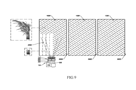
[00103] FIG 9 of the present invention shows the implementation of the
automatic driving
system in the field of the self-driving and the harvesting operations. When
the driving control
system 13 of the grain processing host 10 is in the self-driving mode, the
driving control
28
Date Recue/Date Received 2021-07-05
CA 03125658 2021-07-05
Attorney Docket No.: CA127
Patent Application
system 13 acquires the positioning information of the vehicle 11 provided by
the positioning
device 40, the navigation information provided by the navigation system 50,
and identification
information of the area provided by the image processing system 30, by which
the vehicle 11
is controlled to travel in the unworked area 100 of the farmland to complete
the grain
harvesting operation. During the driving operation, the image acquisition
device 20 acquires
the image in front of the vehicle 11 in real time, wherein the image is
identified by the image
processing system 30 using the image segmentation recognition technology to
identify the area
and the area boundary range. When the divided area and area boundary range
obtained by the
image processing system 30 are inconsistent with the previous area and the
boundary range,
the image processing system 30 replaces the original area and area boundary
range, and
updates the navigation data of the navigation system 50 so that the driving
control system 13
obtains new navigation information to adjust the driving and the working route
of the vehicle
11.
[00104] As shown in FIGs 10 to 11B, based on the positioning information
of the grain
processing host 10 obtained by the positioning device 40, the area planning
information
identified by the image processing system 30, and the navigation information
of the navigation
system 50, the automatic driving system for grain processing generates at
least one planning
path. The driving control system 13 of the grain processing host 10 controls
the driving of the
vehicle 11 and the operation of the operation system 12 according to the
generated planning
29
Date Recue/Date Received 2021-07-05
CA 03125658 2021-07-05
Attorney Docket No.: CA127
Patent Application
path. In one embodiment, the automatic driving system for grain processing
further includes a
path planning system 60, wherein the path planning system 60 plans at least
one driving path
of the vehicle 11 for the grain processing host 10. The path planning system
60 obtains the
positioning information of the positioning device 40, obtains the area
planning information of
the image identified by the image processing system 30, and obtains the
navigation
information of the navigation system 50, and plans the driving path of the
vehicle 11
according to the obtained information.
[00105] Referring to FIG. 11A and FIG 11B, the path planning system 60
identifies or sets
out at least one operation area 601 and at least one operation boundary 602 in
the farmland,
wherein the operation area 601 is the largest operation range of the automatic
driving system
for grain processing, and the driving control system 13 controls the vehicle
11 to travel in the
operation boundary 602. It should be noted that the operation area 601 and the
operation
boundary 602 can be identified by the image processing system 30 identifying
the farmland
boundary area 300 in the image. Alternatively, it is the path planning system
60 which can set
the operation area 601 of the automatic driving system.
[00106] The path planning system 60 plans at least one driving path based
on the outermost
of the operation boundary 602 of the operation area 601. When the width of the
operation area
601 is larger than an operation width of the operation system 12, the path
planning system 60
plans a "circular" shaped driving route or an "s" shaped driving route. It
should be noted that
Date Recue/Date Received 2021-07-05
CA 03125658 2021-07-05
Attorney Docket No.: CA127
Patent Application
the way of the driving route planned by the path planning system 60 is only an
example, not a
limitation. Therefore, other driving routes can also be applied.
[00107] In one embodiment, when the vehicle 11 is travelling to far end
boundary of the
operation area 601, the path planning system 60 replans at least one driving
path based on the
range of the current unworked area 100. Namely, when the vehicle 11 is driving
to the far end
boundary of the operation area 601, the operation area 601 and the operation
boundary 602 are
updated by the path planning system 60 for the vehicle 11, and a new driving
path is planned
according to the updated operation area 601.
[00108] It should be noted that the driving control system 13 controls
the vehicle 11 to
drive according to the driving path planned by the path planning system 60. In
one
embodiment, the driving control system 13 controls the operation system 12 to
harvest the
outermost crop of the operation area 401. Namely, the driving control system
13 controls the
operation system 12 to harvest crop in the unworked area 100 based on the
operation boundary
602.
[00109] Referring to FIG 10, the path planning system 60 of the automatic
driving system
for grain processing includes an area setting module 61, a path planning
module 62, and a path
adjustment module 63. The area setting module 61 identifies the operation area
601 and the
operation boundary 602 of the farmland based on the image processing system 30
identifying
the boundary area of the farmland in the image, or based on setting the grain
processing host
31
Date Recue/Date Received 2021-07-05
CA 03125658 2021-07-05
Attorney Docket No.: CA127
Patent Application
to operate in the operation area 601 and the operation boundary 602 in the
farmland. As the
operation of the grain processing host 10 causes the unworked area 100 and the
worked area
200 to change, the area setting module 61 updates the range of the operation
area 601 in real
time and the boundary of the operation boundary 602 in order to generate a new
unworked
area 100 and a new worked area 200.
[00110] The path planning module 62 obtains at least one driving plan
path 603 based on
the positioning information of the grain processing host 10, the area planning
information of
the image identified by the image processing system 30, and the navigation
information of the
navigation system 50. In one embodiment, the driving control system 13
controls the vehicle
11 to drive according to the driving plan path 603. The path adjustment module
63 adjusts the
driving direction of the grain processing device 10 based on the information
of the crop of the
image identified by the image processing system 30 to generate a vehicle
driving path 604,
wherein the vehicle driving path 604 is basically coincident with or parallel
to the driving plan
path 603. When the image processing system 30 identifies that an adjustment of
a harvesting
range is required, the vehicle driving path generated by the path adjustment
module 63
deviates from the driving planning path 603.
[00111] According to another embodiment of the invention, the invention
further provides
a path planning method used in the automatic driving system for grain
processing, wherein the
path planning method includes steps as below.
32
Date Recue/Date Received 2021-07-05
CA 03125658 2021-07-05
Attorney Docket No.: CA127
Patent Application
[00112] (a) Acquiring at least one image of the farmland around the grain
processing host
10.
[00113] (b)Identifying and dividing the area of the farmland and the
boundary of the
farmland corresponding to the image.
[00114] (c)Planning At least one driving planning path 603 based on the
identified area.
[00115] The path planning method further includes the following steps:
(a.0) setting the
operation area 601 of the farmland and at least one operation boundary 602
corresponding to
the operation area 601. It should be noted that the operation area 601 of the
farmland includes
the worked area 200, the unworked area 100, and the farmland boundary area
300. The
boundary area 300 corresponding to the outside of the farmland coincides with
the operation
boundary 602.
[00116] The path planning method step (a.0) further includes the
following steps:
identifying the operation area 601 and the operation boundary 602 of the
farmland by the
image processing system 30 identifying the farmland area and the boundary from
the image.
[00117] The step (b) of the path planning method further includes the
following steps:
using the image segmentation technique to segment the image, and identifying
and dividing
the region of the image.
[00118] In step (a) of the above path planning method, the image
information around the
grain processing host 10 is captured in real time based on the position and
the driving direction
33
Date Recue/Date Received 2021-07-05
CA 03125658 2021-07-05
Attorney Docket No.: CA127
Patent Application
of the grain processing host 10. In step (b) of the above path planning
method, the image
processing system uses the image segmentation technology to segment the image
information,
and identify and divide the regions from the image as the unworked region 100,
the worked
region 200, and the farmland boundary region 300. Step (b) of the path
planning method
further includes the following steps.
[00119] (b.1) Dividing the image into a number of the pixel regions 301,
and normalizing
the pixel values of the pixel regions 301 into an array.
[00120] (b.2) Extracting the features of the pixel region 301
corresponding to each array.
[00121] (b.3)Outputting a classification label of the image based on the
features of the
pixel region 301.
[00122] In step (b.3) of the path planning method, the classification
label corresponds to
the unworked area 100, the worked area 200, and the farmland boundary area
300.
[00123] In step (b) of the above path planning method, the image
processing system 30
uses the convolution neural network algorithm of the deep learning to divide
the image and
identify the areas of the image.
[00124] In step (c) of the path planning method further includes step
(c.1): Based on the
positioning information of the grain processing host 10, the image processing
system 30
identifies the area planning information of the image and the navigation
information of the
navigation system 50, the driving planning path 603 is obtained.
34
Date Recue/Date Received 2021-07-05
CA 03125658 2021-07-05
Attorney Docket No.: CA127
Patent Application
[00125] The step (c) of the path planning method further includes step
(c.2): adjusting the
driving direction of the grain processing host 10 based on the information
that the image
processing system 30 recognizes the crop of the image to form the vehicle
driving path 604.
[00126] The path planning method further includes: step (d) comparing
whether the
divided area and the area boundary range identified by the image processing
system 30 are
consistent with the previous area boundary range, adjusting the divided areas
and the area
boundary range corresponding to the image when the divided area and the area
boundary
range identified by the image processing system 30 are consistent with the
previous area
boundary range, and keeping the divided area and the area boundary range
unchanged when
the divided area and the area boundary range identified by the image
processing system 30 are
not consistent with the previous area boundary range.
[00127] According to another aspect of the invention, the disclosure
further provides an
automatic driving method applied in the automatic driving system for grain
processing, and
the automatic driving method includes the following steps.
[00128] (1) Acquiring at least one image and identifying the area and the
area boundary of
the farmland in the image.
[00129] (2) Based on the area and the area boundary of the farmland,
planning at least one
driving planning path 603.
[00130] (3) Controlling the grain processing host 10 to move
automatically according to
the driving planning path 603.
Date Recue/Date Received 2021-07-05
CA 03125658 2021-07-05
Attorney Docket No.: CA127
Patent Application
[00131] The step (I) includes the method for automatically identifying
the farmland area
and the farmland boundary provided by the invention. The driving control
system 13 controls
the driving and operation of the grain processing host 10 based on the
farmland area and the
farmland boundary identified by the image processing system 30.
[00132] The step (I) of the automatic driving method further includes:
identifying the
corresponding crop information in the farmland in the image, wherein the crop
information in
the farmland includes the information of the crop type, the height of the
crop, the particle
plumpness.
[00133] The step (II) of the automatic driving method further includes
the following steps.
[00134] Obtaining the positioning information of the grain processing host
10.
[00135] Based on the positioning information, identification information
of the image, and
the navigation information of the navigation system, planning the driving
planning path 603.
[00136] Accordingly, in the step (III), the driving control system 13
controls the driving of
the vehicle 11 of the grain processing host 10 according to the positioning of
the grain
processing host 10, the area planning information of the farmland obtained by
the image
processing system 30, and the navigation information.
[00137] The automatic driving method further includes steps (IV) :
adjusting the operation
parameters of the operation system 12 of the grain processing host 10 based on
the identified
information of the image.
36
Date Recue/Date Received 2021-07-05
CA 03125658 2021-07-05
Attorney Docket No.: CA127
Patent Application
[00138]
Those skilled in the art should understand that the above description and the
embodiments of the present disclosure shown in the drawings are only examples
and do not
limit the present disclosure. The purpose of the present disclosure has been
completely and
effectively achieved. The function and structure principle of the present
disclosure have been
shown and explained in the embodiments. Without departing from the principle,
the
implementation of the present disclosure may have any deformation or
modification.
37
Date Recue/Date Received 2021-07-05